Posts

Showing posts from March, 2022

March 2022 Update SA

Image
March 2022 update SA   *Forecast prepared between Mar 20 th --21st 2022  Review:   G’Day everyone once again, time for the mid-month update, sorry it is late this time around, extra  shiftwork due to staff illness has certainly been testing!  We are currently in the midst of a general reset across the tropics after the onslaught into the east  of the country, with some of that moisture filtering west into low pressure troughs inland resulting  in sporadic showers and thunderstorms and locally heavy falls. One notable fall was in Broken Hill,   a town which has been so dry for many years, and they recorded 72.4mm with a thunderstorm on  the 15 th with flash flooding in town. Also, parts of the Upper SE not far from Lameroo had unofficial  but very believable reports of 100mm+ in a little over an hour and a half.   However, the main dominant feature over much of our state during the first half of March has been  the rid...

Quick little tidbit on today

Image
  Quick little tidbit on today: Currently we have a weak surface trough over the east of the state as well as an upper trough slowly moving across the gulf areas. This upper trough will advance eastwards to be located over Adelaide by about 4:30pm. These two features will combine with an increase in low level moisture from the NE to generate afternoon and evening showers and thunderstorms from convection, but generally north and east of Adelaide. The main focus I would suspect will be the NE Pastoral and Flinders Ranges, down through the Mid North where thunderstorms will have a little more grunt. The Riverland, Murraylands, Upper and Lower SE will also see activity though a little less significant in parts of the Upper and Lower SE than yesterday. Given a second weak trough over the Eyre Peninsula and the westward advection of moisture, I'd also expect development over the Eyre Pen and down the Yorke Pen as well, the latter assisted by seabreeze convergence. Closer to home,...

Quick Update SA Showers and thunderstorms March 14-16th 2022

                                             Quick Update SA Showers and thunderstorms March 14-16th 2022 G’Day all, very quick one today as I’m busy at work but that expected moisture explained from the March outlook associated with the westward moving trough has now begun to have an influence. We have seen some early morning/overnight showers and thunderstorms become active near the SA/NSW border and now with the presence of some more moisture and a weak surface trough are seeing afternoon and evening showers and thunderstorms developing once again along an outflow boundary, chiefly over the Lower and Upper North (generally confined to the ranges) and also in greater numbers over the Flinders Ranges and NE Pastoral which I think will see the greatest activity both today the 14th and tomorrow the 15th. Isolated showers and thunderstorms should also develop down the eastern...

March 2022 Outlook SA

Image
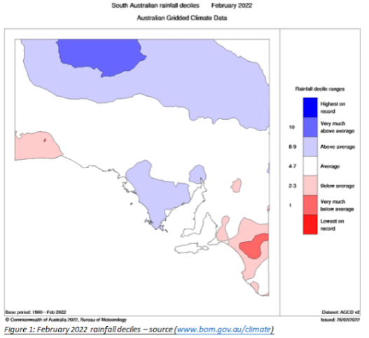
*Forecast prepared between Mar 2nd-3rd 2022 Review: G’Day everyone, I really hope you are keeping well and have managed to score a little bit of rain over the last few days to week with thunderstorms scattered around most districts. It was however still extremely hit and miss. Personally I’ve been struck down with the big C along with my wife and child and am at the start of my 14 days isolation. Have to say it’s all been extremely mild. From the last update in mid Feb, we expected a couple of weak fronts on the 18th and 20th respectively to throw up some light shower activity and that is largely what happened with light totals under 1-2mm for the most part. I only received a trace myself at home, enough to wet the leaves on the rose bushes. Later on in the month we saw that expected moisture pile on into the east of the country which filtered into a westward moving trough anchored over western NSW/VIC and occasionally oscillating into Eastern SA. This trough caused the odd afternoon s...