SA Quick update Upper trough with showers and thunderstorms February 28th-March 1st 2022
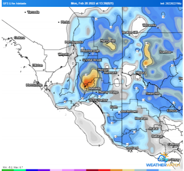
SA Quick update Upper trough with showers and thunderstorms Feb 28th-Mar 1st 2022 G’Day all, thought I’d whip out a quick little update on things tomorrow, after a fairly quiet spell here we are finally getting a bit of instability (well today we already saw the start over the Lower SE) Meteorological Discussion In short, we will see an upper-level low move up from the SW overnight to be located over the Spencer Gulf by sunrise. This low will move slowly eastwards during the day to be located roughly over the southern Mallee by sunset. At the surface being cradled by a large high-pressure system, we will have a trough which will move west and deepen a little in response to the approaching upper low. With these two interacting with each other we will see a de-stabilisation of the atmosphere causing lapse rates to steepen thanks to the cooling aloft provided by the upper low. Initially some mid-level showers and isolated thunderstorms may fire up in some convergence ahead of the ma...
