March 2022 Outlook SA
*Forecast prepared between Mar 2nd-3rd 2022
Review:
G’Day everyone, I really hope you are keeping well and have managed to score a little bit of rain over the last few days to week with thunderstorms scattered around most districts. It was however still extremely hit and miss. Personally I’ve been struck down with the big C along with my wife and child and am at the start of my 14 days isolation. Have to say it’s all been extremely mild.
From the last update in mid Feb, we expected a couple of weak fronts on the 18th and 20th respectively to throw up some light shower activity and that is largely what happened with light totals under 1-2mm for the most part. I only received a trace myself at home, enough to wet the leaves on the rose bushes.
Later on in the month we saw that expected moisture pile on into the east of the country which filtered into a westward moving trough anchored over western NSW/VIC and occasionally oscillating into Eastern SA. This trough caused the odd afternoon shower and thunderstorm, but overall activity was sparse with the main ridge holding the trough out for the most part and no upper-level support.
This all changed from Feb 28-March 1st with an upper trough swinging in from the west and activating the surface trough a lot more with some steepened lapse rates and as a result showers and thunderstorms increased over areas east of the Gulf St. Vincent and especially so over the Upper and Lower SE and many parts of the eastern Mallee. The suburbs of Adelaide also managed to get some local heavy falls from very slow-moving afternoon thunderstorms with the western and inner N/NW suburbs copping the most with up to 60mm or so in half an hour near Grange. The lack of a seabreeze allowed convergence to settle closer to the coast than usual. Many other suburbs and surrounding areas struggled to see a single drop. Thunderstorms also fired up along the trough up the ranges across the Northern Mt. Lofties and through the Lower and Upper North causing localised flash flooding and some small hail.
Overall, though for February looking back it was a mixed month, rain at the very start and the very end with not a lot in between, The heavy rains at the start though have skewed the overall picture of
the month for the most part. But since the Feb outlook was issued most of the month has gone to plan. Here is the outlook posted below.
“Now like last month one big event could certainly destroy any forecasts in summer! However, given we are in a reset right now, the chances of above average rainfall repeating are significantly less. I’d be expecting average to below average rainfall across more southern coastal regions with ridging for the most part holding sway. Inland, moreso across the northern portions of the NW Pastoral we may see the best shot at above average rainfall. Most other areas will be in that average to slightly below average bracket”
And the resultant decile chart in Figure 1 below: Figure 1: February 2022 rainfall deciles – source (www.bom.gov.au/climate)
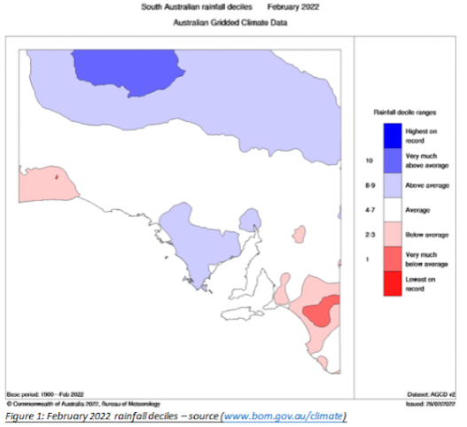
Overall, a better effort than January that’s for sure. The Upper SE fared the worst overall with very much below average, a lot of moisture was held north from there with ridging. Both the NW Pastoral and Eyre Peninsula are skewed given the forecast was made after rains on Jan 31st fell. It was a fair drop off from January and much closer to expectations with E/SE flow and fairly dominant high pressure.
I thought I’d also recap the QLD and NSW floods given how significant they have been with incredible levels of water through places such as Gympie, Ipswich and especially Lismore which comfortably set a new record height for the Wilson River with 4m+ through the town itself in parts.
The setup essentially was driven by three main factors all coming together. There was only one factor missing which if present, would have delivered probably the worst floods in Brisbane’s history.
Firstly, we had a long and sustained trade wind burst bringing in moisture off the Pacific with ridging to the south driving that moisture in from the east and NE. This locked in pattern allows a consistent conveyor belt of moisture to pile in without stopping essentially being the fuel line for the event.
Secondly, we had a strong and near stationary upper-level low move in from the west with colder air aloft providing dynamic uplift of all that moisture. The position and slowness of the upper trough/upper low allowed a sustain NE to N flow through the mid-levels over riding the surface E to NE winds. Winds that back with height are always favourable for heavy rainfall and when patterns do not move, things can get very wet very quickly.
Thirdly there was a surface trough that initially was offshore and hence the event started a little late but as the ridge cradling the trough relaxed a little, the trough was steered back onshore and became near stationary and complex in near perfect sync with the upper low to the NW.
So, the big easterly fetch was the moisture line, the surface trough anchored was the organising factory with convergence and lift from below and the upper trough/low was the big engine aloft giving that extra power and lift (secret herbs and spices if you like) to the entire system. There were added complexities at the surface with meso lows embedded in the trough which continually rotated inshore giving bursts and trains of heavy convective thunderstorms over the same area. If the upper low wasn’t there, then all of this would have been a lot weaker even if the surface trough was anchored.
So, what was the ‘saving’ grace that stopped it being the worst even in history? The level of the dams and catchment before the rain began. In 2011 the Wivenhoe Dam was already close to 100%. That event was not as widespread, or long lasting but one particular area got consistently smashed before all the water came raging downstream. In this event the pre-event capacity was only around 39.6% (see Figure 2) and then we have the enormous spike. You may be asking how and why it can go over 100% capacity and that extra room is the flood storage which is reserved for events like this but needs critical monitoring. If 200% were topped, then they would have an uncontrolled spill from a dam holding twice as much as normal. But more to the point here if we started this event on a 100% capacity, we can see that that 200% would have comfortably been breached. They would have had to release water downstream into a MAJOR flooded region with intense rain falling and increasing levels to prevent the uncontrolled spill of 200%. It would have been a lose lose situation, and I shudder to think at how high the water level may have got if this had been the case. The 4.46m peak from 2011 in Brisbane CBD could have potentially been more likely 6-7m and heavens knows how much higher in areas where the width of the river is less (and thus a greater increase in height from the standard levels would have occurred).

Figure 2: Wivenhoe Dam historical storage % - source (www.seqldwater.com.au/dam-levels)
Rainfall totals from this event over a 4-day period were largely in the order of 600-900mm through the SE QLD district and also parts of NE NSW with higher totals over mountainous areas. The top ones that I can gather are as follows:
Mt.Glorious 1771mm
Bracken Ridge 1160mm
Murrumba Downs 1145mm
Pomona 1150mm
Cooran 1130mm
Upper Springbrook 1121mm
Doon Doon (NSW) 1036mm
Brisbane 793mm
Lismore (NSW) 716mm
It is not wonder such incredible flooding occurred with totals like that and in some cases 300-400mm were falling in a 3-4hour period under training thunderstorms.
Meteorological Discussion:
Now looking ahead through March, I’ve expected an improvement on Feb in the eastern districts but not to levels other places saw in January. Our MJO has weakened and is floating around in phase 5 ish but the eastern states are still being favoured for increased chances of above average rainfall, and I’d expect a bit more of an inland spread through QLD once again as troughs start to see moisture filter into them from over the Great Divide. Once again moderate to strong high pressure will hold a SE/E regime over the state and mainland but westward moving troughs will keep trying to bring moisture in from the east intermittently. I will be watching for any weak upper disturbances from the W/SW to activate this moisture and trigger showers and thunderstorms. A little bit of moisture is also likely in the far west from rainfall associated with Ex Tropical Cyclone Anika but due to no strong westerly belt at the moment, a lot of this will not be captured and uplift into a significant rain even for us, fizzling out through the far western parts of the state.
Currently a front and associated upper low is traversing the state, fairly weak in nature however but is still managing to generate some light to moderate patchy rain within a mid-level band. Behind the front, scattered showers associated with the colder air aloft are occurring but largely confined to the waters below KI and then into the SE Districts tonight (4th). A couple of elevated mid-level weak thunderstorms are also occurring on the back edge of the band but nothing much.
Now the next part is classic SA in March, a large and slow-moving ridge of high pressure. At first the flow will be quite onshore SW-S so we should expect some isolated to scattered light shower activity through 5th-6th and possibly also early morning of the 7th but the flow will be turning more SE. Then the ridge will become slow moving with a classic pattern of afternoon seabreezes and gully winds at night, especially in the usual prone spots on the western slopes of the ranges from the period 7th through till about the 10th or 11th. After this the slow inching movement of the high will allow the wind regime to turn a little more overland from the E and thus steering the developing easterly trough westwards closer to our border and bringing a little moisture west with it. How charged this trough becomes will depend a lot on whether or not some colder air aloft can waffle over the top of this surface trough. If it can then we will see more active showers and thunderstorms within this trough from roughly about the 13th-15th though just a generalised pattern thought at this stage, if the upper troughing remains weaker or absent then it’s quite likely the ridge will muscle up and crush the trough completely. If it does fire up then I’ll issue a special update.
Overall, my outlook for March will see very close to average rainfall, slightly above in the far west and parts of the SE districts with a risk of at least average to above average rainfall this time into the NE pastoral up the border though patchy. Most other areas look about average. The main below average risk is probably over areas such as the southern NW pastoral and down through Yorke Pen and perhaps KI as well which would roughly be a zone between moisture enroaching from the west and influence from the east.
Climate Drivers
The Pacific is showing no signs of letting up with the trade winds and this is no surprise given the insane amounts of moisture that continues to pump into the east of NSW and QLD. We have seen the devastating floods that have occurred due to the result of this moisture and the extra secret herbs and spices was a strong and near stationary upper level low. The current state of the ocean is still showing a mature La Nina with the consistency in the signal being better than last summer.
However, at a depth, there are signs now of an erosion of the cold water left to surface which shows overall that the event has indeed peaked, with the usual lag to the surface to remain plus the secondary lag to the atmosphere. I’d expect a slow dissolving of the cooler anomalies in the coming weeks from this current signal.

Figure 3: Current SST anomalies showing La Nina still well entrenched – source Tropical Tidbits (www.tropicaltidbits.com/analysis/ocean)
The Indian is largely irrelevant at this time of the year as we know when it comes to talking about the IOD, however the warmth is persisting across the basin, and especially the eastern side which is a good thing overall. There is a narrow band of cooler water showing up in the central western Indian which is from monsoon activity largely leftover from when the MJO was quite strong over the Indian a few weeks ago.
The MJO has weakened off from the moderate strength signal in the last update and this has been expected due to the strong trade wind burst that has been sustaining for a while now, those easterlies have essentially belted the westerly burst on the head. Usually when you see a La Nina fully lose steam (and especially when it flips to an El Nino) the westerly bursts make further headway into the Pacific, further and further east each time, thwarting those trades. Not this time, not yet anyways so this is something to watch for in the coming weeks and months which should begin to happen given there is less cold water to rise in the east now, but I suspect it will take some beating to fully remove this signature of La Nina from the ocean with such a slow start and thus my expectation of a likely cool neutral pattern for much of this year remains. Could we even see a triple dip La Nina? And exceptionally rare event and unlikely (though not impossible) but for now I feel a cool neutral would be the frontrunner for next spring and summer.
The SAM has been slightly positive in the last couple of weeks and certainly assisted getting moisture into the mainland. The SAM has now moved to neutral territory and should remain there for a while at least in the wake of the solid moisture assault and troughing in the east over the last few weeks.
Districts:
Eyre Peninsula
Onshore flow to begin with from late 4th-7th with isolated light shower activity, chiefly about Lower Eyre Peninsula and also exposed coasts in the Spencer Gulf. New ridge becoming dominant and slow moving throughout much of the forecast period with dry conditions and a SE regime for the most part. Fresh seabreezes, especially on exposed Spencer Gulf coastline. Rainfall for the period less than 1-2mm over coastal districts of Lower Eyre Pen and Eastern Eyre Pen.
Upper North
Onshore flow to begin with from late 4th-7th with some isolated light showers about elevated terrain or light drizzle patches. New ridge becoming dominant and slow moving throughout much of the forecast period with dry conditions and a SE regime for the most part with fresh to occasionally strong nocturnal gully winds on western slopes from 7th through till 10th approx. Slight chance of westward moving surface trough to filter moisture in from east after 13th with possible afternoon/evening shower and thunderstorm activity. Rainfall for the period less than 1mm in the south and about elevated terrain. If any storms do form, totals will be very localised in the order of quick 10-15mm dumps.
Lower North
Onshore flow to begin with from late 4th-7th with some isolated light showers about elevated terrain or light drizzle patches. New ridge becoming dominant and slow moving throughout much of the forecast period with dry conditions and a SE regime for the most part with fresh to occasionally strong nocturnal gully winds on western slopes of the ranges from 7th through till 10th approx. Slight chance of westward moving surface trough to filter moisture in from east after 13th with possible afternoon/evening shower and thunderstorm activity. Rainfall for the period less than 1-2mm in the south and about elevated terrain. If any storms do form, totals will be very localised in the order of quick 10-15mm dumps.
Yorke Peninsula
Onshore flow to begin with from late 4th-7th with some isolated light showers, chiefly about the foot of Yorke Peninsula. New ridge becoming dominant and slow moving throughout much of the
forecast period with dry conditions and a SE regime for the most part with fresh afternoon seabreezes from 7th through till 10th approx. Rainfall for the period less than 1-2mm and generally closer to the foot.
Kangaroo Island
Upper trough to pass below KI with some scattered showers possible, chiefly E KI through evening of 4th.Onshore flow to begin with from late 4th-7th with some isolated to scattered light showers. New ridge becoming dominant and slow moving throughout much of the forecast period with dry conditions and a SE regime for the most part with fresh afternoon seabreezes from 7th through till 11th approx. Rainfall for the period less than 2-5mm.
Adelaide Plains
Onshore flow to begin with from late 4th-7th with some isolated light showers or drizzle patches about elevated terrain and southern suburbs. New ridge becoming dominant and slow moving throughout much of the forecast period with dry conditions and a SE regime for the most part with fresh to occasionally strong seabreezes and nocturnal gully winds on western slopes of the ranges from 7th through till 10th approx. Rainfall for the period generally less than 1-4mm in the south and about elevated terrain.
Mt.Lofty Ranges
Onshore flow to begin with from late 4th-7th with some isolated to scattered light showers or drizzle patches about elevated terrain and certainly southern coasts and ranges. New ridge becoming dominant and slow moving throughout much of the forecast period with dry conditions and a SE regime for the most part with fresh to occasionally strong seabreezes and nocturnal gully winds on western slopes of the ranges from 7th through till 10th approx. Rainfall for the period generally less than 3-8mm though some streams may set up about Southern Coasts with lower cloud causing slightly more continuous precipitation at times with totals possibly nearing 10mm.
Riverland/Mallee
Onshore flow to begin with from late 4th-6th with some isolated light showers about the Lakes in the SW Mallee. New ridge becoming dominant and slow moving throughout much of the forecast period with dry conditions and a SE regime with fresh winds for the most part from 7th through till 10th approx. Slight chance of westward moving surface trough to filter moisture in from east after 13th with possible afternoon/evening shower and thunderstorm activity. Rainfall for the period less than 1mm in the SW and about elevated terrain. If any storms do form, totals will be very localised in the order of quick 10-15mm dumps.
Upper SE
Patchy rain clearing eastwards late 4th with front but cold air aloft with upper low to bring more scattered showers overnight and into 5th. Onshore flow then to begin from late 4th-7th with some isolated light showers about the coast and closer to the Lakes. New ridge becoming dominant and slow moving throughout much of the forecast period with dry conditions and a SE regime with fresh winds for the most part from 7th through till 11th approx. Slight chance of westward moving surface trough to filter moisture in from east after 13th with possible afternoon/evening shower and thunderstorm activity but a low chance at this stage. Rainfall for the period less than 1-3mm in the SW and about elevated terrain. If any storms do form, totals will be very localised in the order of quick 5-10mm dumps.
Lower SE
Patchy rain clearing eastwards late 4th with front but cold air aloft with upper low to bring more scattered showers overnight and into 5th. Onshore flow then to begin from late 4th-7th with some isolated to scattered light showers. New ridge becoming dominant and slow moving throughout much of the forecast period with dry conditions and a SE regime with fresh winds and afternoon seabreezes, strong about the coast for the most part from 7th through till 11th approx. Slight chance of westward moving surface trough to filter moisture in from east after 13th with possible afternoon/evening shower and thunderstorm activity but a low chance at this stage. Rainfall for the period less than 3-6mm. If any storms do form, totals will be very localised in the order of quick 5-10mm dumps.
Final Notes:
· La Nina still remains and impacts are significant for the Eastern states with more flooding likely both coastal and inland before the season is finished
· Cool neutral currently leading bets for most of the winter and spring period
· Still expecting a drier spell or possibly even an Indian summer like through parts of April and May
· Tropical Cyclone activity to pick up a little through mid to late March and April but total numbers looking below average for a La Nina. This trend has been consistent for years now.
Happy farming and cheers from The Weatherman
*Note – For interest only, all thoughts are of The Weatherman and may not be reproduced without my consent.


Comments
Post a Comment