Posts

Showing posts from November, 2023

Quick Update SA upper low/trough with showers, rain & thunderstorms Nov 27-28th

Image
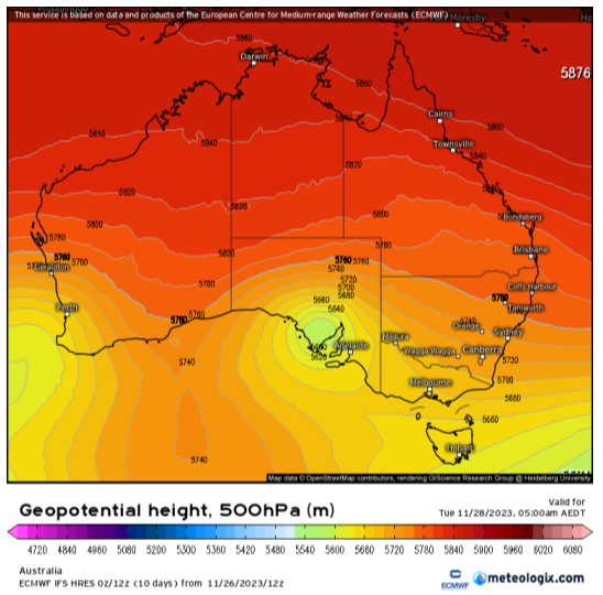
Quick Update SA upper low/trough with showers, rain & thunderstorms Nov 27-28th G’Day everyone, time for a quick update once again to cover this small but strong little event that has been developing over the last day or so. Due to the small scale of the upper low, a slight shift in track would have resulted in a very different scenario but due to such firm blocking of the westerly belt caused by a strongly positive SAM, we have seen once again another small but stout upper low pinch off and roll up into SA and this will be a focus for severe weather over the next 24-36hours across the central and eastern portions of the state. Figure 1: ECMWF 500hPa (18,500ft) thickness chart showing upper low over SA @ 4:30am local on 28/11/23. Also note ‘omega’ like block pattern with upper ridge in between the two upper lows. Source - Meteologix Meteorological Discussion: In short, an upper low is currently wandering north through the Bight. Across the northern flank of this is a developing mid

Special Update SA Trough and upper low with showers

Image
Special Update SA Trough and upper low with showers, rain and thunderstorms Nov 22nd-25th 2023 ***Forecast prepared evening of Tues 21st and morning of 22nd. G’Day everyone, thought I would put out that update as promised for this event, and certainly it is a complex one with some implications for those still harvesting, especially in the east of the state over locations chiefly east of the ranges. In terms of changes from the forecasts mid-month, no major ones but there is a slight westward movement of the activity as a whole thanks to the upper low pushing NW a bit more which will allow more rainfall across the agricultural areas as a whole with a higher bottom line (hinted in forecast as my gut feel told me this will be the case...always trust the gut...always!) Meteorological Discussion: For this update, I thought the best way is to break the event down into separate days, so it is nice and clear for all to read and understand. We are still a couple of days out from the main action

November update 2023 SA

Image
November update 2023 SA *Forecast prepared between November 15th-17th 2023 Review: G’Day everyone, I hope you are keeping well as we move to the halfway point of November, a busy time for many I am sure with the harvest. I hope for those that do receive this that your frost damage is not too bad, but I understand there are some areas that have not fared too well. I truly hope your 2024 is a much kinder one – I think it should be rainfall and frost-wise. So far this month we haven’t seen a great deal of active weather with a relatively settled and stable pattern across the state. Heat has made a couple of moves south however ahead of a trough, the main one on the 10th where Adelaide came very close to the hottest ever day this early in the season with 40.3C (it needed to beat 40.4C). Many other areas across the Pastorals and agricultural areas moved into the 41-44C range with 44.3C at Tarcoola, 44.2C at Kyancutta & Whyalla, 44.1C at Port Augusta and 44C at Woomera. Rainfall has been

November outlook 2023 SA

Image
November outlook 2023 SA *Forecast prepared between November 1st-5th 2023 Review: G’Day everyone, another month of the year down and November is now upon us, which no doubt many of you are extremely busy in with harvest in full swing, certainly much earlier than this time last year. October was not a kind month, both for being dry but also for the very nasty late frost that came with it with the morning of the 26th being the worst with a snap frost across many locations and I will expand on that below shortly. The general trend for the month was a mobile pattern however aside from some thunderstorm activity on the evening of the 2nd with some fortunate rain areas across the southern NE Pastoral and weak fronts, significant rainfall simply didn’t happen with most changes being dry and windy before new ridges pushed in behind. The main event however was the frost on the morning of the 26th which was a snap frost and, in some locations, caused a rare but devastating black frost where part