Posts

Showing posts from September, 2022

September 2022 Update SA

Image
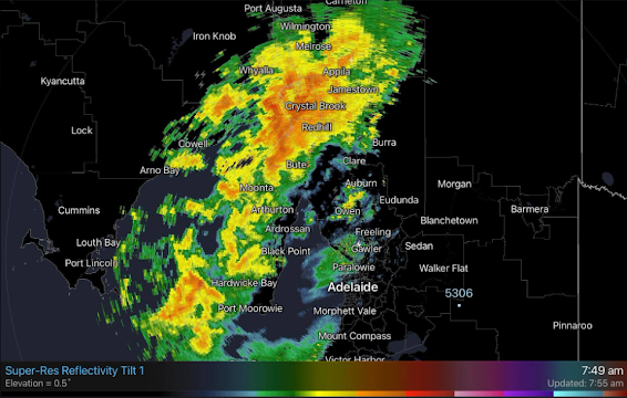
                                                          September 2022 update SA *Forecast prepared between September 17th-19th 2022 Review: G’Day everyone, and already time for that Mid-month update, things are certainly happening with lots of active systems and rainfall, but that is a fantastic thing at this time of the year, and it is re-assuring that nearly everything is going to plan (with the exception of some nasty frost very early September). Crops will start to get big and thirsty now and demand more moisture, so regular rainfall will still be needed for many. As mentioned, the early month frosts from the 3rd till 6th did not help things in some districts but the N Yorke Peninsula into the Lower North did cop some nasty hits with stem frost, especially those low-lying valleys. Hopefully this damage that I did see was not too widespread. In terms of rainfall events there have been plenty with copious fronts and cut off the lows however the most significant even occurred on th

Quick Update - SA Series of fronts Sept 14-18th 2022

Image
                                    Quick Update SA series of fronts Sept 14-18th 2022 G’Day one and all, thought I’d throw a quick little update out before the usual mid-monthly given we have a series of fronts on the way and the combination of all of these should deliver more good falls to many districts, a nice follow up after the last event. This was mentioned as a potential cut off low with rain then showers in the September outlook so good to see it roughly come out. Meteorological Discussion: Wed 14th A trough of low pressure will move swiftly in from WA, squeezing the isobars tightly ahead of it causing windy conditions. Strong ascent aloft will promote a vigourous low level jetstream out of the NE/N from the early hours of the day ahead of the trough. This should be sufficient to trigger high based showers and thunderstorms on and ahead of the trough. These will likely be quite lightning active over the West Coast, Eyre Peninsula and Bight areas before dawn, rapidly advancing

Special Update Cut off low Sep 7-9th 2022

Image
                                            Special Update Cut off low Sep 7-9th 2022 Meteorological Discussion G’Day everyone, as promised a special update on the system due to impact us from the 7th although it is already starting out in the far west of the state with some showers and thunderstorms developing west of the Nullarbor in response to the strong upper trough moving in. I’ll break the discussion down into days so timelines can be clear. Wednesday 7th: A broad and deepening low pressure trough will extend eastwards across the state during the day. Aloft a sharpening upper trough will strengthen upper-level divergence and become negatively tilted later in the day – this means the colder air aloft leans forward where the top portion of the trough is leaning further east than the bottom (see attached Figure 1) Severe weather is most common with these types of systems, and I have to say they have always been my favourite for both rain and thunderstorms generally speaking althoug

September 2022 Outlook SA

Image
                                                  September 2022 outlook SA *Forecast prepared between August 31st-September 5th 2022 Review: G’Day everyone, and spring has sprung! My favorite season of the year (apart from the hay fever but that’s life). A big Happy Father's Day to you all as well for Sunday. (Apologies for the late issuance of the update, was a busy weekend with work and family gatherings). No doubt many of you will be pleased with how August turned out, I have to say it went almost exactly to plan which was good to see after a very bad July. I did expect the springback and for the most part we received average to above average rainfall. I’ll post some charts below: As we can see from the above images, the month was quite good for the agricultural areas with average to above average rainfall – something much needed after July. There were a number of significant frontal systems as well as a couple of cut off lows, some already covered in the mid-month update with