Posts

Showing posts from July, 2022

Quick Update SA two fronts with rain areas July 22-25th 2022

Image
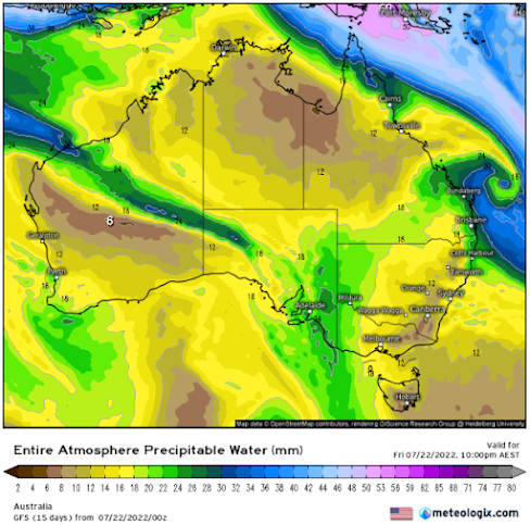
                      Quick Update SA two fronts with rain areas July 22-25th 2022 G’Day everyone, just a quick update on the fly for these two fronts inbound, I touched briefly on them in the mid-month update with the first to bring some mid-level showers and then the second to be sliding but potentially squeeze the jetstream with some patchy rain areas but holding mostly north of southern ag areas. The good news at least (as I’m sure many of you are aware of now) is that there have been some handy upgrades, moreso over the Eastern to SE Districts. So, what has changed in the last week? The main difference has been the resultant moisture leftover from the inland upper low over Central S QLD/N NSW where some good 25-50mm falls have occurred. The large high-pressure cradling this has developed an impressive low level jetstream which has angled the moisture in. Refer to figure 1 for the first system. Figure 1: Entire Atmospheric Precipitable Water chart for 09:30pm local on 22/07/22 - so

July 2022 update SA

Image
                                                            July 2022 update SA *Forecast prepared between July 15th-16th 2022 Review: G’Day everyone, the middle of July is already upon us, and I have to say the first half of the month has been pitiful for rainfall, not that it was unexpected from the outlook, but I’d say it’s even underachieved in parts, my place in Adelaide has only had 3.4mm so far. Dynamically, the east coast has been dominated by wet conditions caused by multiple ECL’s which have acted as a roadblock to everything else to the west. At the same time, the SAM has been positive with highs favoring a more southern anchor completely smashing the westerly belt down plus the MJO has been moving away again and weak over the Top End and into the Pacific. Moisture continues to feed down from the very warm Coral Sea (see climate drivers section) into lows over the Tasman further assisted by these frequent upper troughs that wander up above the surface high pressure systems.

July 2022 Outlook

Image
*Forecast prepared between July 1st-4th 2022 Review: G’Day everyone, I hope you are all keeping well as we now have winter upon us! A time of good hearty roasts, warm fires and red wine (I must say it’s not just winter I’ll enjoy those). A fire though wouldn’t be a bad idea with the frosty period we have had recently as high-pressure systems take hold.  A look back since the last update has seen a gradual drying trend with less significant systems with more limited inland penetration which has been caused by purely onshore moisture only without proper connection to the tropics. A series of weak fronts did most of the rainfall, with extra orographic assistance into the Adelaide Hills giving better totals there. The Mallee and Riverland as well as the Upper North and Northern Eyre Peninsula generally came up short from these shallow fronts. The most significant period was between the 20th-27th where many districts recorded at least 0.2mm on each day with damp and drizzly conditions at ti