Posts

Showing posts from April, 2022

May 2022 Outlook SA

Image
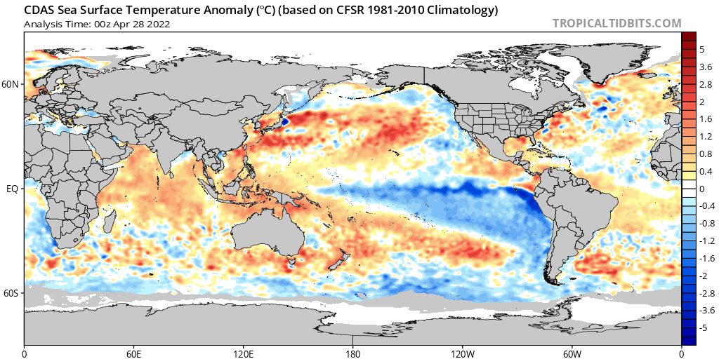
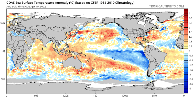
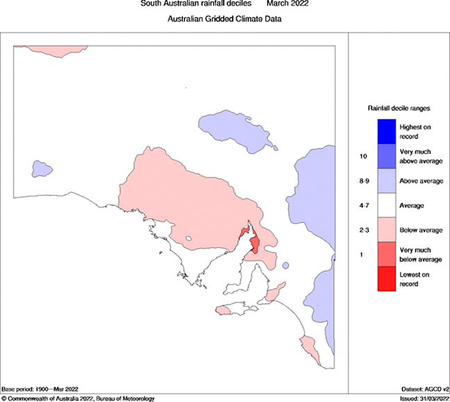
May 2022 outlook SA *Forecast prepared between Apr 27th-28th 2022 Review: G’Day one and all, this outlook comes a little earlier than usual but as I’ll be away from the 30th and not back till late on the 6th, I thought I’d push it out early. Yes, that might affect a few little tidbits but overall shouldn’t make too much difference. We are starting to change and will explain more through the sections below. Recently, as per the special update we’ve managed some very solid inland rainfall, with lighter falls extending to some agricultural areas, chiefly the western and northern however some low-level moisture combined with orographic lift and drizzly continuous rain periods gave some locally higher totals on the back side of the ranges with 30mm at Keyneton in the NE flow which is extremely rare to see but no doubt welcome. Otherwise, the rainfall was close to expectations apart from the Lower and Upper North which were light on. Some 10-15mm falls in the Riverland which would have been

Special Update SA Upper trough with rain/showers April 24-27th

Special Update SA Upper trough with rain/showers April 24-27th Meteorological Discussion: G’Day everybody, it’s come to that time now where a special update is required as that end of month system has developed accordingly although it is not without it’s limitations. At present it is Sunday 24th morning and we have a weak surface trough angled down across the centre of the state from the NE generating some isolated mid-level showers – Altocumulus Castellanus and a sure sign of de-stabilising mid-levels. Shower activity is more scattered to widespread across the NE Pastoral and Flinders where moisture depth is greater along with increasing isolated thunderstorms. This activity with the NE steering present, thanks to the deep and strong high further to the S/SE offshore, will continue down towards the Eyre Peninsula and West Coast districts throughout the afternoon and evening and gradually expand and thicken into areas of rain tonight, especially over the West Coast where I would expect

April 2022 Update

Image
April 2022 update SA *Forecast prepared between Apr 17th-18th 2022 Review: G’Day everyone, hope you have had a great Easter so far spent with your families, it sure has been a busy one here between work and social commitments, I think a workout or two will be needed considering the food and chocolate consumed! The last couple of weeks has seen predominantly dry conditions dominated by high pressure systems however there was one moderate upper trough with a band of rain that traversed chiefly south-Central districts of the state with some light falls. Better rainfall was recorded in the southern Adelaide area and about the ranges in the order of 8-10mm. A secondary trough that was the remannts of a strong cut off low over WA (which gave some tremendous falls) delivered a decayed patchy rainband to mostly the West Coast and Eyre Peninsula. This would have been handy for that region with 7-15mm falls recorded, which will keep the soil in good condition given the huge summer rainfall that

April 2022 Outlook SA

Image
  April 2022 outlook SA   *Forecast prepared between Mar 31st-Apr 4th 2022   Review: G’Day everyone, another month down, actually hard to believe we are now well into autumn and before we know it winter will be here.   A month of being stuck in between two main infeeds east and west with heavy falls and major flooding as expected sadly in NSW and also parts of QLD. Finally, WA saw some heavy falls for the first time all summer, but SA was dominated by constant ridging which was continuously re-enforced from the Bight creating stable conditions for the most part through especially Central areas. We did see the eastern border areas in the earlier part of the month come under the influence of a surface trough which generated diurnal shower and thunderstorm activity with some locally heavy falls, especially over parts of the Upper SE and also the Flinders and NE Pastoral.   Looking back at the March outlook I think overall it performed well for the expected pattern bu