Posts

Showing posts from December, 2023

Special Update VIC/East SA Upper & sfc low with rain, showers and thunderstorms Dec 24th-26th 2023

Image
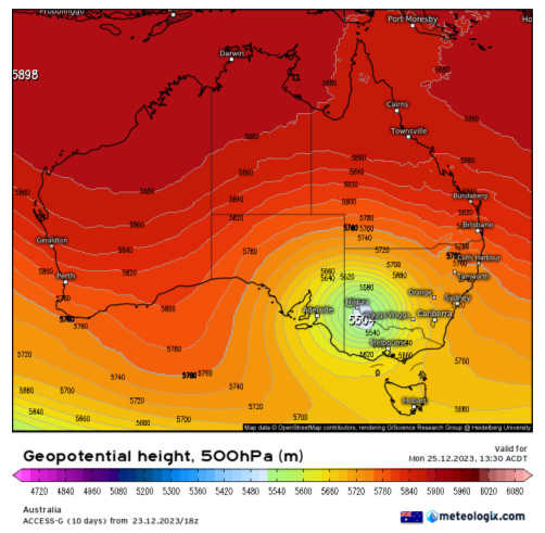
Special Update VIC/East SA Upper & sfc low with rain, showers and thunderstorms Dec 24th-26th 2023 ***Forecast prepared morning of 24th*** G’Day everyone, as promised if the system showed a westerly trend, then I would issue a special update and certainly at the 11th hour, it really has done that with more of an east-west stretch out of the event, which is what happened a bit with the last upper low as well. It is blocked in and strong enough to push back on both sides of the baroclinic leaf area although this time the main band will feature more thunderstorms than rain initially. I’ll break it down again into days. Meteorological Discussion: I should also make note of the major high end thunderstorm outbreak across SE QLD and NE NSW over the same period, with numerous waves of damaging supercell thunderstorms. This upper low is the main culprit being so strong and far north for this time of the year meeting a warm and humid airmass creating extreme instability with high end wind s

December update 2023 SA

Image
December update 2023 SA *Forecast prepared between Dec 18th-21st 2023 Review: G’Day one and all, the last update for 2023 is here unless we get some significant events before the month comes to a close. I’ll get right into it as the first half of this month certainly has brought a very major event, one I said would be remembered for many years to come and that will definitely be the case, it took me right back to December 1992 on my memory bank when I was only a wee tacker in early primary school. The main point of discussion of course was the thumping, slow-moving cut off upper low that dominated the weather across the agricultural areas and adjacent interior for much of the period from December 9-12th with rain, showers and multiple thunderstorms, many forming in trains with one after another passing over the same area, all in all came off as expected with no surprises. I unfortunately did not get time to pop out another update for the more thundery conditions that were expected Mon

Special Update SA Complex Upper low with rain

Image
***Forecast prepared evening of Friday 8th. Meteorological Discussion: G’Day everyone, as promised a little update on this major rain event. I was planning a longer update but got a second call into work in as many nights! Like last time I will break it down into the days. The main changes is the shift west in the entire event, and whilst it looked significant for the NE EP and W Upper and Lower North last time, the focus now shifts to a large bulk of the EP and up into the NW Pastorals with a reduced rainfall impact east of the gulfs over the Upper and Lower North which in many ways is a sigh of relief for those still harvesting. There will still be some rain, however. Expansion below. Figure 1: ECMWF 500hPa (18,500ft) chart showing powerful upper low over the Bight on 130pm local central time on 11/12/23. Note no westerly belt in sight showing the complete cut off. Also note the size comparison to TC Jasper off Cairns, a massive difference! - source Meteologix Saturday 9th Strong upp

December Outlook 2023 SA

Image
*Forecast prepared between Dec 3rd-6th 2023 Review: G’Day everyone, I hope you are keeping well as we now move into summer, a time where most harvest begins to wind up and for some of you that may be the case however, I do know that many are still going, especially those further south and those that have been interrupted by rain and storms which no doubt have thrown a spanner in the works. Let's get right into the review of November, a month that was a tale of two halves or even less than that with the first part being quite dry before a blocking pattern set up triggering complex systems with wandering upper-level lows. The first was a cut off upper low that was moderate in strength and dragged in some moisture from the east generating areas of rain mainly but some isolated thunderstorms as well. The main event did come a little earlier than anticipated with cooler low-level temperatures and mid-level cloud causing a drastic drop in instability across many agricultural areas on the