Posts

Showing posts from May, 2022

Special Update SA Strong Cold Front and Cut off Low May 29th-31st 2022

Image
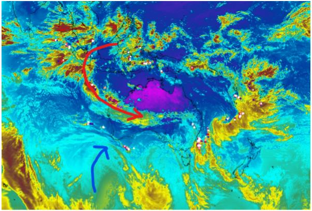
Special Update SA Strong cold front and cut off low May 29th-31st 2022 Review: G’Day everyone, time to discuss this up and coming system and a significant one it still looks to be at that. This is the seasonal breaker for most districts. As explained in the previous update, we will see an increase in the penetration and strength of the systems as our pattern changes and season breaks. We begun with some scattered showers and isolated thunderstorms out west which weakened to patchy rain and general showers towards Central Districts before re-developing again out east and north the next day. Rainfall was patchy but most districts ranged between 3-12mm. Some isolated totals were record about the ranges and Eyre Pen over 20mm and numerous holes over both the Lower and Upper North as well as the Mallee. Further convective cells have flowed across the south central portions of the state both yesterday 27th and again today with a weakening front on the 28th ticking over some more totals and i

Special Update

Further Update Saurday, please check blog. Quick Update SA trough with showers and isol thunderstorms May 24-25th 2022 G’Day everyone, just a quick little update on the first system in the sequence of many over the next week or so. Currently we have a trough moving through the Bight and West Coast District which is the same system that barrelled viciously through SW WA yesterday delivering squally showers and thunderstorms including a tornado out over the wheatbelt showing the powerful dynamics at play. The system as expected has begun to weaken but has managed to bring down some moisture from the warming Indian ahead of it, evident by the cloudband that is present over Central and Eastern SA (1030pm local on 24th). Now if you had your eye on the sky over the past few days you would have noted quite a bit of surfaced based convection around during the late mornings and early to mid-afternoons and this was due to the NE flow bring in moisture out of the very damp eastern seaboard.

Mid-May 2022 update SA

Image
  May 2022 update SA Please keep your eyes on Alex Gills Twitter and Facebook page and Peter Blackets for notifications of blog updates. No direct messaging anymore, takes too much time.  All updates will be between 28-5th of the month and mid-month 14-18th and special updates as needed.  *Forecast prepared between May 16-18th 2022 Review: G’Day everyone, sorry it’s been a while between the last update and this one, quite a bit has been  happening! Firstly, the planned fishing trip out to Fowlers Bay and surrounds went well for a week  before tracking back through Elliston for a couple of nights. Then onto some major sinus surgery for  myself on the 11th, can’t say that I recommend it, but I know long term it should be good – nothing  quite like a new snoz after many years of grief. Now due to the May outlook being issued before the end of April, I wasn’t able to give you the final  charts to discuss how the month performed so I will do this here. 2 / 11 Figure 1: April 2022 rainfall d