March 2022 Update SA
March 2022 update SA
*Forecast prepared between Mar 20th--21st 2022
Review:
G’Day everyone once again, time for the mid-month update, sorry it is late this time around, extra shiftwork due to staff illness has certainly been testing!
We are currently in the midst of a general reset across the tropics after the onslaught into the east of the country, with some of that moisture filtering west into low pressure troughs inland resulting in sporadic showers and thunderstorms and locally heavy falls. One notable fall was in Broken Hill,
a town which has been so dry for many years, and they recorded 72.4mm with a thunderstorm on the 15th with flash flooding in town. Also, parts of the Upper SE not far from Lameroo had unofficial but very believable reports of 100mm+ in a little over an hour and a half.
However, the main dominant feature over much of our state during the first half of March has been the ridge to the south which has directed a fresh SE flow over most districts, and this is pretty much expected for this time of the year after all, SA is the ridge state.
Meteorological Discussion:
The remainder of the month will see a bit more activity on the east and west of the country but not a huge amount through SA. Currently moisture is building off the NW coast over the Indian Ocean and is largely associated with Tropical Cyclone Charlotte which at this stage has been struggling to organise however I would expect some rapid intensification overnight tonight (21st) with a maximum intensity in the Severe Category 3 range tomorrow afternoon. There is a good outflow channel to the poleward side aloft which will help this intensification before it gradually weakens heading SW with dry air entrainment, cooling SST’s and increasing wind shear. The key is how much influence the next approaching upper-level trough/westerly belt change will have on a recurve back towards the SE. This will be critical in determining how much rain parts of WA get, with many being very dry this summer. At this stage I’d be a little surprised if it did cross the coast at TC strength or above but more so get torn up offshore first with increasing shear with the remnants then being carried back
across on the strong upper-level winds generating patchy rain areas for the SW of WA. A trough is then likely to linger down the west coast of WA and pull in a lot of moisture that was channeling into the system from the north to generate a fair deal of shower and thunderstorm activity, more than there has been for a fair bit of this summer at least. The core however even as an Ex-Tropical Cyclone will likely contain damaging winds so take heed to warnings if it gets close and you live that way or know people who do!
Back for SA though we are in the midst of generally light airs with no strong ridge influence over the last two days. That has caused warm to hot and fairly stagnant conditions aside from some nocturnal gully winds. A trough will cross from the west tomorrow (22nd) with a band of mid-level showers or patchy rain as it draws on moisture from TC Charlotte. An isolated thunderstorm is possible also, mostly likely though over the West Coast, Eyre Peninsula and Upper North districts which will repeat through the afternoon potentially over the Flinders to NE Pastoral in the afternoon of the 23rd with a surface trough lingering though these may struggle to get up as the trough is very weak.
Behind the trough will see a stronger ridge establish and push in from the west driving cooler conditions in from the south with southern maritime air giving light coastal showers to exposed areas through evening of 22nd and possibly also 23rd. Beyond this the ridge will do it’s usual thing and progress steadily eastwards.
An interesting feature however will be tracking the path of an upper-level trough from the 24th-27th. This should pinch off into an upper low over NSW and will likely lead to another period of severe weather for areas chiefly ahead of this feature where moisture will once again (sounds like a broken record atm) feed in from the east and be uplifted. I can see more heavy showers, rain areas, severe thunderstorms and general damage from flooding caused by this system but not the level we saw late Feb.
The main interest no doubt lies in what happens from here on in for April and beyond. I’ve mentioned I expect one more strong burst out of the tropics into the mainland and this is starting to show signs of beginning as mentioned above but it would be unfortunate for SA to miss completely before we go into an Indian Summer like pattern through mid to possibly late April. If it is strong it could persist into May. We have a lot of warm SST’s but at this stage no significant triggers to really bring that moisture down hard. It could continue to bake which would make for a strong break when it finally does come through May and June. I will be tracking the SAM closely through the April May period as it will certainly give rise to how long we should remain dry or dryish at least with minor insignificant systems.
Winter at this stage looks fairly stock standard, perhaps with at least warmer SST’s off WA we will have a greater chance of rainbands rather than just showery fronts but that needs to persist plus the
SAM needs to launch heavily negative which is always struggle in La Nina events that linger like this one. It should be gone back to cool neutral then, however.
Climate Drivers
We certainly have a Pacific that is refusing to lay down the La Nina signature, compared to last year we are holding firm which no major changes from the last update – good trades putting in good amounts of moisture into Australia’s east with a persistent cooler signature in the central to eastern Pacific. The depth of colder water beneath has eased a little but there is still some down there to rise and this will keep things lingering on a little longer.
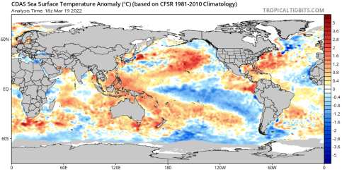
Figure 1: Current SST anomalies – source Tropical Tidbits
https://www.tropicaltidbits.com/analysis/ocean/
The Indian is warm, no doubt about and if we look at Figure 1, we can clearly see the extra heat around the western side of the mainland. The entire country is circled by warmer than average temperatures to be honest and this will be primed for one more assault from the tropics before the season is largely done as mentioned before. There are signs finally that WA may see more influence this time from the tropics, we already have TC Charlotte south of Indo and plenty of convection over the water so moisture should feed S to SSE towards WA, the only question is how much goes below the mainland and how much actually crosses the coast. The most likely area at this stage is the bottom corner of WA but with thunderstorms inland.
Moving on to the MJO and it is currently in phase 3 and moving towards the mainland once again after gathering strength over the Indian in the last week or so. This is no surprise given the increase convection in this region. It should remain slow moving between phases 3-5 over the coming weeks before slowly petering out in the Western Pacific. This should open the window for increased Tropical Cyclone activity as mentioned in the last update from Mid-March onwards and likely to continue well into April. The next area to watch for a spin up is the Gulf of Carpentaria or Arafura Sea.
The SAM is fairly neutral atm, perhaps a slight positive tendency but not like it was and cannot see any major changes for the meantime. Upper troughing will take hold over the east in the coming week which is often the case when surface ridging is strong. As mentioned before, the eastern states will benefit the most from this, especially NSW.
I thought I’d also quickly touch on the record ‘heat’ recorded over parts of the Antarctic Continent in recent days with some places being 30C or so above average. The values are no doubt appear much more significant and to the untrained eye will raise alarm but there is no need. A simple explanation is due to the fact that a significant fetch of moisture channeled southward on the western periphery
of strong high pressure ridging in the Pacific due to La Nina. This moisture channeled south in the form of an atmospheric river in a highly meridional setup which is essentially an opening of a channel from the tropics to the mid-latitude areas. On occasion these can keep going towards the poles and in this case, right to Antarctica triggering all those records. Given it is so dry down there, an increase in moisture will increase the temperature quite significantly due to the higher Specific Heat Capacity of moisture. It is very likely this event will stand out for many years to come unless we can get another opening/atmospheric river.
Districts:
Eyre Peninsula
Weak trough passing through the region on 22nd with some mid-level showers or patchy light rain. Brief isolated thunderstorm or two likely, especially about the West Coast. Stronger ridge pushing in behind driving light showers in onshore flow to exposed coastal areas overnight 22nd into 23rd. Fresh sea breezes. Ridges likely to dominate for remainder of month with SE/E flow for the most part however a trough or cold front could impact late from 29th onwards with some shower activity but at this stage not looking significant. Rainfall 1-4mm mostly falling on 22nd.
Upper North
Weak trough passing through the region on 22nd with some mid-level showers or patchy light rain. Brief isolated thunderstorm or two likely, especially about the Flinders. Isolated afternoon thunderstorm possible on 23rd over northern Flinders. Stronger ridge pushing in behind with milder conditions and freshening SE/E flow once again and nocturnal gully winds. Ridges likely to dominate for remainder of month with that SE/E flow for the most part however a trough or cold front could impact late from 29th onwards but at this stage, nothing significant. Rainfall 1-3mm mostly falling on 22nd.
Lower North
Weak trough passing through the region on 22nd with some mid-level showers or patchy light rain. Brief isolated thunderstorm or two possible, especially towards the north. Stronger ridge pushing in behind with milder conditions and freshening SE/E flow once again and nocturnal gully winds. Light shower or two likely about elevated terrain overnight 22nd into 23rd. Ridges likely to dominate for remainder of month with that SE/E flow for the most part however a trough or cold front could impact late from 29th onwards but at this stage, nothing significant. Rainfall 1-2mm mostly falling on 22nd.
Yorke Peninsula
Weak trough passing through the region on 22nd with some mid-level showers or patchy light rain. Brief isolated thunderstorm or two possible, especially towards the north. Stronger ridge pushing in behind with milder conditions and freshening SE/E flow once again and fresh sea breezes. Light shower or two likely in onshore flow overnight 22nd into 23rd. Ridges likely to dominate for remainder of month with that SE/E flow for the most part however a trough or cold front could impact late from 29th onwards but at this stage, nothing significant. Rainfall 1-3mm.
Kangaroo Island
Weak trough passing through the region on 22nd with some mid-level showers or patchy light rain. Stronger ridge pushing in behind with milder conditions and freshening SE/E flow once again and fresh seabreezes. Scattered light showers likely in onshore flow overnight 22nd into 23rd. Ridges likely to dominate for remainder of month with that SE/E flow for the most part however a trough or cold front could impact late from 29th onwards but at this stage, nothing significant. Rainfall 1-3mm.
Adelaide Plains
Weak trough passing through the region on 22nd with some mid-level showers or patchy light rain. Stronger ridge pushing in behind with milder conditions and freshening SE/E flow once again and nocturnal gully winds. Light showers in onshore flow overnight 22nd into 23rd especially about the southern suburbs. Ridges likely to dominate for remainder of month with that SE/E flow for the most part however a trough or cold front could impact late from 29th onwards but at this stage, nothing significant. Rainfall 1-3mm.
Mt.Lofty Ranges
Weak trough passing through the region on 22nd with some mid-level showers or patchy light rain. Stronger ridge pushing in behind with milder conditions and freshening SE/E flow once again and nocturnal gully winds about western slopes. Scattered showers in an onshore flow, more frequent about exposed southern coasts and ranges overnight 22nd and into 23rd. Ridges likely to dominate for remainder of month with that SE/E flow for the most part however a trough or cold front could impact late from 29th onwards but at this stage, nothing significant. Rainfall 1-6mm mostly falling on 22nd and about those exposed southern coasts and ranges of the Fleurieu Peninsula.
Riverland/Mallee
Weak trough passing through the region on 22nd with some mid-level showers or patchy light rain. Brief isolated thunderstorm or two likely, especially in the evening and about the northern Riverland. Stronger ridge pushing in behind with milder conditions and freshening SE/E flow. Light shower or two possible late on 22nd to 23rd morning also in onshore flow in far SW of Mallee. Ridges likely to dominate for remainder of month with that SE/E flow for the most part however a trough or cold front could impact late from 29th to 30th onwards but at this stage, nothing significant. Rainfall 1-2mm mostly falling on 22nd.
Upper SE
Weak trough passing through the region on 22nd with some mid-level showers. Stronger ridge pushing in behind with milder conditions and freshening SE/E flow once again. Scattered light showers overnight 22nd into 23rd chiefly in the W/NW. Ridges likely to dominate for remainder of month with that SE/E flow for the most part however a trough or cold front could impact late from 29th to 30th onwards but at this stage, nothing significant. Rainfall 1-2mm.
Lower SE
Weak trough passing through the region on 22nd with some mid-level showers, more isolated in the south, however. Stronger ridge pushing in behind with milder conditions and freshening SW to SE flow once again. Scattered light showers overnight 22nd into 23rd chiefly about the coast. Ridges likely
to dominate for remainder of month with that SE/E flow for the most part however a trough or cold front could impact late from 29th to 30th onwards but at this stage, nothing significant. Rainfall 1- 2mm.
Finals Notes:
• La Nina is not done yet and the tropics remain active with renewed Tropical Cyclone activity for the coming weeks.
• Upper low to combine with Pacific moisture to bring more wet weather and flooding to parts of Eastern Australia.
• Drier period still firming after last tropical burst with Indian Summer like conditions mid to later April or early May.
To find the latest update, please bookmark https://farmweathersa.blogspot.com/ This is a temporary site only, but work is in the pipeline for a subscription service on a new website long term. Any issues let your contacts know. Many thanks!
Happy farming and cheers from The Weatherman
*Note – For interest only, all thoughts are of The Weatherman and may not be reproduced without my consent.


Comments
Post a Comment