Posts

February update 2024 SA
Image
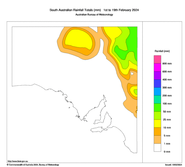
February update 2024 SA *Forecast prepared between Feb 19-22nd, 2024 Review: G’Day everyone, a little late with the February update sorry, had driver duties to Melbourne for the wife to see Miss Swift. Talk about bedlam!! Reminds me why I like living in little Ol Adelaide. But enough of that, a quick look back at how the month is going so far reveals that there have been no surprises whatsoever. An expected below average month rainfall wise has so far seen a grand total of 0.0mm over essentially the entire agricultural area with the exception of the NE Riverland. Please see Figure 1 below: Figure 1: February month to date rainfall showing the dry spelk over agricultural areas – source BoM http://www.bom.gov.au/climate/ The far NE of the state has been quite wet thanks to the influence of tropical moisture, chiefly from Ex TC Kirrily when it moved through the region. Together with this, heavy rainfall and major flooding over the border in Channel Country and general NW QLD, has seen flo...

February Outlook 2024 SA

Image
February outlook 2024 SA *Forecast prepared between Jan 31st-Feb 3rd, 2024 Review: G’Day one and all, February is now here and time to have a look at what is in store for us in the final month of summer, traditionally a hot and dry one for SA, however this year the heat will primarily remain inland with less dips south than the average Feb. Firstly, as usual, we will have a look back at January and we can certainly say it kicked off 2024 with quite a bang in many districts with both good rain, thunderstorms and decent humidity, not just in SA but across the greater east whilst the Top End and Northern parts of QLD (and to a lesser extent the top of the Kimberly) saw a solid onset of the monsoon. The main event in the second half of the month for SA was a narrow but well received rainband with heavy convective areas embedded in a training line which largely focused through the Central portions of the Adelaide Metro area with remnant moisture feeding down from the slow moving Monsoonal L...

January Update 2024 SA

Image
  January update 2024 SA *Forecast prepared between Jan 14th-15th 2024 Review: G’Day everyone, time for a mid-month update as the summer rolls on. We’ve certainly seen a change in conditions across the Top End of Australia however down south the changes have been a little less obvious with a lack of true heat filtering down as well as troughs and general intermittent instability at times. The main example of this was from the system we had through the 6th and 7th with showers, thunderstorms and rain areas. The system as a whole though was a bit weak with focus and a general detachment between the surface trough to the east and the upper trough to the west. Nevertheless, some strong thunderstorms did form, with Quorn copping one of the better ones on the 5th iirc ahead of an MCS (Mesoscale Convective System) that moved across Pastoral areas and the Flinders late on the 6th. On the 7th, the humid airmass was present with poor timing for maximised thunderstorms over Central areas but ...

January outlook 2024 SA

Image
January outlook 2024 SA *Forecast prepared between Jan 3rd-4th 2024 Review: G’Day everyone, Happy New Year and hope that 2024 brings good health and prosperity to you all. Looking back at December and it certainly finished 2023 with a bang with a wet and thundery month across many districts with multiple days of thunderstorms, with many severe thunderstorms. After the mid-month update the heavy rain did ease off however, the back side of the deep cut off low over the Eastern states resulted in a truly miserable Christmas Day (coldest on record for many locations) with fresh to strong southerly winds, light drizzly showers and mostly cloudy conditions. I know I certainly needed a jumper on outside most of the day. This system gave enormous rainfalls across multiple states with VIC, NSW, QLD copping the most significant weather. No doubt the standout talk was the destructive thunderstorm which mowed down a path through the Border Ranges area of SE QLD with a long path of snapped trees, f...