January Update 2024 SA
January update 2024 SA
*Forecast prepared between Jan 14th-15th 2024
Review:
G’Day everyone, time for a mid-month update as the summer rolls on. We’ve certainly seen a change in conditions across the Top End of Australia however down south the changes have been a little less obvious with a lack of true heat filtering down as well as troughs and general intermittent instability at times. The main example of this was from the system we had through the 6th and 7th with showers, thunderstorms and rain areas. The system as a whole though was a bit weak with focus and a general detachment between the surface trough to the east and the upper trough to the west. Nevertheless, some strong thunderstorms did form, with Quorn copping one of the better ones on the 5th iirc ahead of an MCS (Mesoscale Convective System) that moved across Pastoral areas and the Flinders late on the 6th. On the 7th, the humid airmass was present with poor timing for maximised thunderstorms over Central areas but far eastern border areas received severe thunderstorms with some brief supercells near Paruna as well as into NW VIC near Mildura which I went for a drive to have a look at. Very green in parts out there right into Mildura. Very friendly farmer on the outskirts of Mildura came out on his tractor with his lad to see if I was ok, which was much appreciated (was just taking some photos) so if you are reading this mate, was nice to meet you!
Across the Top End we have seen a monsoon incursion which has been expected for a number of weeks now. Heavy rain, as well as increasing squally monsoonal showers and thunderstorms are occurring with the maximised impacts to come from Monday to Wednesday as the flow across the top side of the low gets squeezed. Whilst this is by no means a strong monsoon thanks to a lack of cross equatorial flow, it is locally enhanced thanks to the low which due to it being so deep and strong, is generating that damaging monsoonal flow across the top side. Heavy flooding rain will develop across the base of the top end and south into the desert areas of NT as this monsoon low shifts south whilst maintaining strength.
Also, I should note the strong gully winds that occurred chiefly on the night of the 13th just before I began this update with 30-45knot gusts down the western slopes of the ranges, especially enhanced in the usual areas like Sellicks Beach and Noarlunga/Seaford with some minor damage recorded from branches down and one tree in Woodcroft in Adelaide’s southern suburbs.
Meteorological Discussion:
Now looking forwards about what we can expect for the remainder of the month and to be honest, there are no real changes in the broadscale pattern.
With respect to the current monsoon, it is by no means a strong monsoon thanks to a lack of cross equatorial flow, however it is locally enhanced thanks to the low which due to it being so deep and strong, is generating that damaging monsoonal flow across the top side. Heavy flooding rain will develop across the base of the top end and south into the desert areas of NT as this monsoon low shifts south whilst maintaining strength. Further east, more heavy rain will also extend across the Cape York Peninsula with a focus on the western side with the flow off the Gulf of Carpentaria, however previous areas affected by flooding around Port Douglas and Cairns will certainly receive a further dose of heavy to very heavy rainfall which will be worth keeping an eye on.
The eastern half of the country is still generally under the influence of a dominant easterly regime with highs to the south and broad troughing inland fuelling diurnal showers and thunderstorms, with some severe. With westward steering of this trough, moisture will creep back into SA from the east and join up with a weak trough or convergence area moving in from the west/NW. This already has triggered some isolated to scattered afternoon and evening showers and thunderstorms on the 13th. These are expected to continue today on the 14th in similar areas, but with a little more focus into the NE of Eyre Peninsula where an active thunderstorm is currently moving NE near Iron Knob delivering flash flooding there with 30-40mm in an hour. Surface based convection will develop primarily over the ranges across the Upper North and up the Flinders as well as the northern parts of the Lower North. A repeat is expected on the 15th but with a little more towards the Riverland/eastern border districts also as that moisture creeps west from NSW and VIC.
The main event however is on Tues 16th as the two troughs merge into one with a greater focus for uplift. Afternoon and evening showers and thunderstorms will develop across Central and Eastern Districts primarily with a focus on the ranges or off the back side of the Mt.Lofty Ranges but also quite scattered across areas north of there. Isolated severe thunderstorms will develop as well with damaging winds, large hail (2-3cm or so) and locally intense rainfall with a flash flooding threat under the strongest storms, mostly towards the far eastern border. These will certainly be your classic build ‘em up from small Cumulus to a wall of Cumulonimbus in the afternoon with seabreeze enhancement, before contracting eastwards with the trough across all eastern districts (including the SE Districts). The Eyre Peninsula is also expected to see these, chiefly Central and Eastern Eyre Peninsula. The more southern coastal districts and western side of the ranges generally which get washed out easily and early from seabreezes will remain generally fine for the most part. Adelaide itself probably remains mostly fine, but there is a risk for the northern suburbs and outer NE suburbs near the ranges in the early to mid-afternoon before the cells move eastwards.
There will also be some patchy rain areas drifting SE in the mid-levels across areas mostly north of about Whyalla to Port Pirie to Gluepot or so where an approaching upper trough well south of the mainland will give some squeeze to the atmosphere aloft up here along a jetstream.
After this it is getting complex to say the least. A deep low will be induced near Tasmania as the upper trough interacts with the surface trough to the east with much higher quantities of moisture feeding into it. This low will be quite intense for a short period with rain and thunderstorms for VIC and Tasmania with heavy falls likely (quite the theme this year!).
Over SA, a new ridge will move through the Bight and clear the weather eastwards though wed 17th may still see some isolated afternoon showers and thunderstorms about the eastern border, more likely north of about Yunta.
Now beyond this, the upper ridge with baking heat will begin to make its presence felt. Over the Pilbara, this heat has been baking for months now with little rainfall or cold air surges to clean it out or dilute it. The blocking pattern we have been seeing has held this here but now that the monsoon has finally started (late) we are going to see this heat start moving around in an anticlockwise manner around the upper ridge/upper high that will anchor across the mainland. Whilst this is a very large upper ridge, the lack of a tall stand up longwave to the west will most likely keep the trajectory of the worst of the heat further north than coming right south. Given the raw potential of this airmass, I expect close to or potentially some new site records to occur as this moves through with some 50C temperatures and possibly even a new Australian record at locations low lying enough like Oodnadatta (current record holder), Moomba and Birdsville to name a few. The timing of the main axis of the heat will be the factor in whether this happens or not. But overall, the main period for this upper ridge will be from about the 20th-27th with a main peak around 24th-26th for those areas mentioned above. A slight chance in the shape however of this upper ridge may allow this heat to push further south with high 40’s likely if that were to occur. As it stands, there will still be low to mid 40C temperatures across the agricultural areas. A special update should follow as we get closer to the heat event and a better idea of where the worst may lie. Hopefully the main trajectory remains well inland.
There remains an outside chance that some of this monsoonal moisture will make its way down into SA with the potential for a significant rainfall event, but the movement of these lows is tricky to pin down. I think the heat is the most likely scenario first before we see some form of trough system with rain or thunderstorms developing. I’ve left that off the rainfall projections for the districts for now due to the high uncertainty of that but if there is any year for it, this is the year so will keep you informed.
Climate Drivers:
Moving onto the climate drivers and there has been a steady cooling off the southern coastline and SE coastline of SA thanks to the sustained SE-E flow we have seen over the last month or so. This has caused cold water to upwell from the deep and thus temperatures have dropped by 3-4C in this region. There is now a large phytoplankton bloom as a result of this nutrient rich cold water. The signature can be seen in Figure 1 below.
Now over the Pacific, the El Nino has weakened slowly but is still official as far as the numbers are concerned. But just because the numbers say it is, doesn’t mean the impacts are consistent with the values because as we know, other factors are having a far greater influence than the El Nino on our weather right now (that being the SAM and the Tongan Volcanic water vapour release into the stratosphere). The Coral Sea has warmed which is loading us ahead of the monsoonal period to provide that extra warm, moist reservoir for heavy tropical rain and moisture infeeds. Essentially the entire Pacific from west to east across the equatorial regions is above average. There is no ocean to atmosphere connection left now or very little with that El Nino. In time that area of above average will turn on its head with the classic cooler than average ‘V’ shape appearing on the anomaly charts as we move through the middle and latter parts of 2024. The Humboldt Current will be another to watch, and we can see it already slowly making a comeback off the west coast of South America with the cooler anomalies inching north. In short, I expect the La Nina in the Pacific for 2024 of a moderate strength but as El Nino breaks down before hand, all that heat will be released into the atmosphere or push into the Indian and essentially provide a prolific and enhanced reservoir of tropical moisture to consistently feed into the nation, priming it for flooding this year.
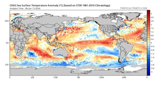 |
| Figure 1: Current SST anomalies – source Tropical Tidbits https://www.tropicaltidbits.com/analysis/ocean/cdas-sflux_ssta_global_1.png |
The Indian has continued to warm across the entire basin just about with the exception of a small patch off the SE coast of Madagascar. The Positive IOD has completely decayed as the Eastern Indian warms significantly. A very much above average area remains across the central Indian Ocean which will likely load up as we approach autumn this year. Essentially, we will be assaulted from both sides of the nation when it comes to moisture feeding in further priming us for significant rainfall across the nation through this year. I also expect a negative IOD to set up as mentioned previously. A lot of boxes will be ticked to maximise rainfall in 2024.
The MJO is currently in phase 4 across the top of the nation and has largely been responsible for triggering the first monsoon onset (a mighty late one at that, one of the latest in recent times anyways). It is of a moderate strength but is likely to gain some further strength as it pushed into the Pacific, head on into some enhanced trade winds which will cause massive convergence as it does so and likely spin up a low or even a Tropical Cyclone as it does so across either the Coral or further east into the Pacific. This push should continue at the same strength into phase 7 which will allow big heat to at first push south before a final pushdown of moisture and then the SW push out. This may trigger significant rainfall through the SE of the nation, but trajectory is very much up in the air.
The SAM is positive and has been for a number of months with very minor blips to the neutral region. I can only see sustained positive values in the next 2 weeks before perhaps a better move to neutral by later Jan or early Feb.
Districts:
Eyre Peninsula
Trough developing from the west on 15th with isolated late showers and thunderstorms towards the West Coast possibly tending to patchy light rain through the 16th over the north of the district. Becoming humid during 16th with isolated afternoon showers and thunderstorms, chiefly north of about Cummins and possibly scattered over Eastern Eyre Peninsula. Patchy rain areas continuing in the far north towards the Pastoral areas. Locally heavy falls in slow moving thunderstorms. New ridge moving in from Bight on 17th before moving eastwards clearing humidity and thundery activity. Deepening upper ridge from about 21st bringing potential for very hot conditions, especially in the west and north with temperatures in the low to mid 40’s, possibly higher to around 48-49C with northern extent. New ridge likely after about 26th with a temporary clearance before more heat rounds out the month. Rainfall for period 3-8mm generally however localized falls to 40mm in an hour are possible with thunderstorms on afternoon of 16th.
Upper North
Trough over the eastern border moving west on 15th with isolated afternoon and evening showers and thunderstorms. Becoming humid during 16th with trough extending from the west generating possible early elevated high based thundery showers and patchy rain areas towards the north. Afternoon and early evening showers and thunderstorms developing on and east of the ranges or outside areas affected by mid to upper cloud cover. Locally heavy falls in slow moving thunderstorms with flash flooding and damaging winds possible. Patchy rain to follow across the Flinders and far NE of the district into the evening and early on 17th. New ridge moving in from Bight on 17th before moving eastwards clearing humidity and thundery activity. Deepening upper ridge from about 21st bringing potential for very hot conditions, especially in the west and north with temperatures in the low to mid 40’s, possibly higher to near 48-49C with northern extent up near Port Augusta. New ridge likely after about 26th with a temporary clearance before more heat rounds out the month. Rainfall for period 3-8mm generally though less than 1-2mm closer to the Gulf coastline. Localised falls to 50mm in an hour are possible with thunderstorms on afternoon of 16th.
Lower North
Trough over the eastern border moving west on 15th with very isolated afternoon and evening showers and thunderstorms, chiefly in the north of the district. Becoming humid during 16th with trough extending from the west. Afternoon and early evening showers and thunderstorms developing on and east of the ranges. Locally heavy falls in slow moving thunderstorms with flash flooding and damaging winds possible. New ridge moving in from Bight on 17th before moving eastwards clearing humidity and thundery activity. Deepening upper ridge from about 21st bringing potential for very hot conditions, especially in the far north of the district with temperatures in the low to mid 40’s. New ridge likely after about 26th with a temporary clearance before more heat rounds out the month. Rainfall for period 2-5mm generally though less than 1-2mm closer to the Gulf coastline. Localised falls to 50mm in an hour are possible with thunderstorms on afternoon of 16th.
Yorke Peninsula
Trough over the eastern border moving west on 15th with secondary trough extending from the west later with increasing high cloud. Becoming humid during 16th with trough extending from the west. Isolated afternoon showers and a possible thunderstorm in the north. Locally brief heavy falls possible in thunderstorms. New ridge moving in from Bight on 17th before moving eastwards clearing humidity and thundery activity. Deepening upper ridge from about 21st bringing potential for very hot conditions, especially in the far north of the district with temperatures in the low 40’s. New ridge likely after about 26th with a temporary clearance before more heat rounds out the month. Rainfall for period 1-3mm generally though potentially nil in several locations. Localised falls to 30mm in an hour are possible with thunderstorms in the north on afternoon of 16th.
Kangaroo Island
Trough over the eastern border moving west on 15th with secondary trough extending from the west later with increasing high cloud. Becoming humid during 16th with trough extending from the west but generally remaining dry as a cooler SW change established behind the trough. New ridge moving in from Bight on 17th before moving eastwards clearing humidity though isolated light onshore showers are possible in the southerly flow. Deepening upper ridge from about 21st bringing potential for hot conditions with temperatures rising in the mid to high 30’s. New ridge likely after about 26th with a temporary clearance before more heat rounds out the month potentially ahead of a trough system extending from the west with sliding patchy rain areas. Rainfall for period generally less than 1-2mm in onshore flow but possible 2-5mm from late trough system.
Adelaide Plains
Trough over the eastern border moving west on 15th with secondary trough extending from the west later with increasing high cloud. Becoming humid during 16th with trough extending from the west. Isolated afternoon showers and a possible thunderstorm about the outer northern/NE plains and adjacent foothills/NE suburbs otherwise remaining fine. Locally brief heavy falls possible in thunderstorms. New ridge moving in from Bight on 17th before moving eastwards clearing humidity and thundery activity. Deepening upper ridge from about 21st bringing potential for very hot conditions, especially over the outer plains of the district with temperatures in the low 40’s. New ridge likely after about 26th with a temporary clearance before more heat rounds out the month. Rainfall for period 1-3mm generally though potentially nil in several locations towards the western and southern suburbs. Localised falls to 30mm in an hour are possible with thunderstorms in the north on afternoon of 16th.
Mt.Lofty Ranges
Trough over the eastern border moving west on 15th though remaining fine with increasing high cloud. Becoming humid during 16th with trough extending from the west. Afternoon and early evening showers and thunderstorms developing on and east of the ranges. Locally heavy falls in slow moving thunderstorms with flash flooding and damaging winds possible. New ridge moving in from Bight on 17th before moving eastwards clearing humidity and thundery activity. Deepening upper ridge from about 21st bringing potential for hot to very hot conditions, especially over the Barossa with temperatures in the low 40’s. New ridge likely after about 26th with a temporary clearance before more heat rounds out the month. Rainfall for period 1-5mm generally though less than 1-2mm on western slopes. Localised falls to 50mm in an hour are possible with thunderstorms on afternoon of 16th.
Riverland/Mallee
Trough over the eastern border moving west on 15th with isolated afternoon and evening showers and thunderstorms. Becoming humid during 16th with trough extending from the west. Afternoon and early evening showers and thunderstorms developing, less likely with western extent later in the afternoon. Locally heavy falls in slow moving thunderstorms with flash flooding and damaging winds possible. Slight chance of large hail in strongest storms towards the VIC border. Patchy rain to follow across the far N of the Riverland during the later evening and early on 17th. New ridge moving in from Bight on 17th before moving eastwards clearing humidity and thundery activity. Deepening upper ridge from about 21st bringing potential for very hot conditions, especially with northern extent over the northern Riverland with temperatures in the low to mid 40’s. New ridge likely after about 26th with a temporary clearance before more heat rounds out the month. Rainfall for period 5-10mm, chiefly east of the Murray. Localised falls to 60mm in an hour are possible with thunderstorms on afternoon of 16th.
Upper SE
Trough over the eastern border moving west on 15th with isolated afternoon and evening showers and thunderstorms, chiefly in the far N towards the Mallee. Becoming humid during 16th with trough extending from the west. Afternoon and early evening showers and thunderstorms developing, less likely with western extent later in the afternoon. Locally heavy falls in slow moving thunderstorms with flash flooding and damaging winds possible. Slight chance of large hail in strongest storms towards the VIC border. New ridge moving in from Bight on 17th before moving eastwards clearing humidity and thundery activity. Deepening upper ridge from about 21st bringing potential for very hot conditions, especially with northern extent with temperatures in the high 30’s to low 40’s. New ridge likely after about 26th with a temporary clearance before more heat rounds out the month. Rainfall for period 5-10mm, chiefly the eastern half of the district. Localised falls to 50mm in an hour are possible with thunderstorms on afternoon of 16th.
Lower SE
Trough over the eastern border moving west on 15th with possible afternoon shower in the far NE but generally remaining fine. Becoming humid during 16th with trough extending from the west. Isolated afternoon and early evening showers and thunderstorms developing, less likely with western and southern extent later in the afternoon. Locally heavy falls in slow moving thunderstorms with flash flooding and damaging winds possible in the far NE. Upper trough moving in from west mostly below mainland triggering a small band of showers on 17th. New ridge moving in from Bight on 17th before moving eastwards clearing humidity and thundery activity. Lingering isolated coastal onshore showers into 18th before eventually clearing later. Deepening upper ridge from about 21st bringing potential for very hot conditions, especially with northern extent with temperatures in the high 30’s. New ridge likely after about 26th with a temporary clearance before more heat rounds out the month. Rainfall for period 3-8mm, chiefly the eastern half of the district. Localised falls to 40mm in an hour are possible with thunderstorms on afternoon of 16th.
Western VIC
Trough over the SA/VIC border moving west on 15th with isolated afternoon and evening showers and thunderstorms. Becoming humid during 16th with trough extending from the west during the day. Afternoon and early evening showers and thunderstorms developing, less likely with eastern and southern extent later in the afternoon. Locally heavy falls in slow moving thunderstorms with flash flooding and damaging winds possible. Slight chance of large hail in strongest storms over both the western halves of the Mallee and Wimmera. Patchy light rain possible late 16th early 17th over the northern Mallee. Upper trough below mainland interacting with surface trough on 17th to trigger renewed showers and isolated thunderstorms in the far east, possibly tending to rain areas at times. Local heavy falls once again in thunderstorms. New ridge moving in from Bight on 17th before moving eastwards clearing humidity and thundery activity. Deepening upper ridge from about 21st bringing potential for very hot conditions, especially with northern extent with temperatures in the
high 30’s to low 40’s, especially about the Mallee. New ridge likely after about 26th with a temporary clearance before more heat rounds out the month. Rainfall for period 5-10mm, chiefly the the far eastern and western halves of the districts but overall, highly variable due to the convective nature of the precipitation. Localised falls to 60mm in an hour are possible with thunderstorms on afternoon of 16th and similar towards the Central Districts on the 17th.
Final Notes
- Monsoon incursion has begun and thus heavy rainfall will increase across the Top End before spreading south
- Baking heat locked up over WA for months will be released around large upper high, with possible near record temperatures across multiple states, but primarily the Far North of SA and SW QLD.
- If upper ridge orientation changes, heat will spread further south than anticipated with agricultural areas seeing temperatures in the mid to high 40’s (low chance at this stage)
- Likely Tropical Cyclone over Coral Sea, impacting coastline near Townsville before travelling inland with further flooding rainfall
- SW push late month and early Feb as MJO travels to east clearing out this humid pattern before resetting for another go mid to late February
- Overall outlook for the growing season in 2024 remains wet with above average rainfall in at least 75% of the months, especially with La Nina and Negative IOD likely
I will officially launch this year with some new progress made with respect to my current work arrangements with an expectation that things will be up and running by mid-year at the latest for those of you wishing to subscribe. I also am open to customers anywhere in the nation and am happy to expand upon my primarily SA based forecasts.
Looking forward to working with you all, it is time to put the trust back into the phrase ‘The Weatherman’
Link to temporary blog website: https://farmweathersa.blogspot.com/
Happy Farming and Cheers from The Weatherman
*Note – For interest only, all thoughts are of The Weatherman and may not be reproduced without my consent.


Comments
Post a Comment