February update 2024 SA
February update 2024 SA
*Forecast prepared between Feb 19-22nd, 2024
Review:
G’Day everyone, a little late with the February update sorry, had driver duties to Melbourne for the wife to see Miss Swift. Talk about bedlam!! Reminds me why I like living in little Ol Adelaide.
But enough of that, a quick look back at how the month is going so far reveals that there have been no surprises whatsoever. An expected below average month rainfall wise has so far seen a grand total of 0.0mm over essentially the entire agricultural area with the exception of the NE Riverland. Please see Figure 1 below:
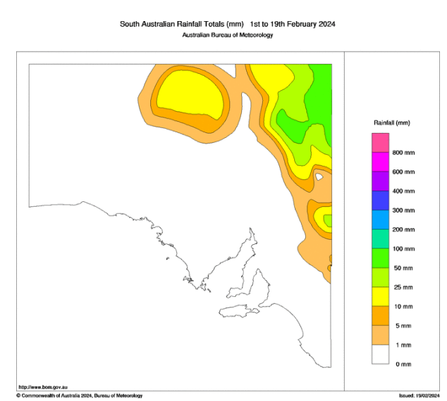 |
| Figure 1: February month to date rainfall showing the dry spelk over agricultural areas – source BoM http://www.bom.gov.au/climate/ |
The far NE of the state has been quite wet thanks to the influence of tropical moisture, chiefly from Ex TC Kirrily when it moved through the region. Together with this, heavy rainfall and major flooding over the border in Channel Country and general NW QLD, has seen floodwaters moving downstream through the main river systems as expected as they make their way towards Lake Eyre. This will be the first of many flows.
I should also note the incredible heat through WA, chiefly the western coasts from the Pilbara, down through the Gascoyne and into the greater SW including Perth. Current conditions in and around Perth are fairly close to what Adelaide and surrounding SA experienced in Jan 2014 which was extremely hot. Carnarvon recorded 49.9C, Shark Bay 49.8C, Geraldton Airport 49.3C with all 3 being records. In terms of all-time records, that puts Carnarvon and Shark Bay 5th and 6th respectively in history. Whilst that sounds drastic, it honestly is not as there has been plenty of similar heat in the past but in slightly different areas. It only takes a slight shift west of the surface trough to bring heat to low levels which is where the really big temperatures occur (like Mardie and Onslow).
Meteorological Discussion:
Now onto current events and there isn’t a huge amount to discuss at least for SA, though some weak troughing is causing some isolated showers and thunderstorms across VIC with some localised heavy dumps as well as hail. Similar conditions occurred over Western NSW on 21st near Balranald or just east of with a locally intense thunderstorm.
But broadly speaking we are in a reset phase across the nation, with a lack of major triggers across the nation with the exception of Ex TC Lincoln which has been delivering heavy rainfall across the northern third of the NT and also parts of the Northern WA as it drifts west. Lincoln is then expected to re-develop into a Tropical Cyclone once again and prob get to a strong category 1 or weak category 2 before recurving around as a longwave trough grabs it. The coastline somewhere around Cape Cuvier to Shark Bay at this early stage seems the most likely place for a crossing before it weakens to below cyclone strength, traversing SSE then SE across the eastern portions of the Central West. The system will bring some very much needed rain (and likely cause flooding) to these parched and drought affected areas of WA, among the driest in the country where many locations have not received any meaningful rainfall in over a year. The downside is the impacts will be along a fairly narrow band so some areas will unfortunately still miss out such as those to the south of about Perth in the SW corner of the state though the band itself will spread out as it moves SE through the areas east of Perth across the Central Wheatbelt. General totals near to crossing and a couple of hundred km inland of that look to be a solid 40-80mm within the core of the band with isolated 100-150mm totals possible with some flooding likely. Further SE across the Wheatbelt and adjacent areas the band spreads out and totals drop back but still a handy 15-35mm seems feasible with isolated 50mm possible.
Back in SA, much of this moisture will disperse before it reaches us with the remnants going below the continent for the most part unfortunately.
Of more immediate relevance is a deep low that is rapidly forming to the waters below the mainland with a strong upper trough behind helping wrap it up. Colder air within this will move NE and clip the coastline on Friday 23rd before a strong new ridge pushes in behind quickly. Isolated coastal showers generally south of about Adelaide will move through till early afternoon (a little more frequent potentially about the Southern coasts and ranges of the Fleurieu and Lower SE District) where they will then largely clear as the new ridge pushes in. This ridge will then dominate the weather for the next few days till the 25th or so when another weak coastal change moves it with a new ridge behind. This should then move quickly east allowing the heat that has built over WA to once again flux down ahead of a low-pressure system. Very hot conditions are therefore likely around the 27th-28th before a cooler change rounds out the month. Temperatures are likely to reach the high 40’s out over the Far West of the state on the 27th in the order of 47-48C or so out near Nullarbor with 44-47C temperatures likely in several centres across more Central and Eastern Districts on the 28th, especially so if the change on the 28th is later in the day, maximising the heat potential. If however, the change crosses through the morning period, then potentially only eastern districts will see the extreme heat. Fire danger will also be elevated, especially on the 28th as winds freshen ahead of the change so please take heed given we have dried out a lot with no rainfall this month. I do expect fire weather warnings to come out in advance for this event, with extreme values and potentially one or two districts in the catastrophic range.
 |
| Figure 2: ECMWF Fire Weather Index for 28/02/24 @ 13:30ACDT. Values over 90 considered especially significant. |
The early indicators for March is for an increase in moisture across the tropics with significant inland penetration including renewed heavy falls and flooding. Some of this moisture will filter down to the southern portions of Australia thanks to the path cleared by TC Lincoln, changing the shape of the upper ridging and generally shifting that east which will allow moisture to move down into WA with greater ease for the first time in the season. A wetter month than February nationwide that is for sure.
Climate Drivers:
The Pacific continues to show an El Nino, but as we know the influence of that is minimal to zero here in Australia. It is still however significant over in the USA and any talk of El Nino not existing or having any exertion on the world is nonsense. Historic flooding through Los Angeles and parts of California with 300-400mm of rain, severe flash flooding with some locations receiving their entire annual rainfall in 36hours as an atmospheric river event set up, funnelling NE ahead of a strong upper trough. Essentially the USA version of our NW cloudband but it was a SW cloudband instead. Much rarer over there and only in an El Nino do you see this sort of activity.
The sub-surface continues to cool which is a sure sign the El Nino event is coming to an end in an official sense, with the cooler water to continue to accumulate and then surface as trade winds continue to blow strongly from the NE. We should see La Nina then replace the El Nino within 6months.
The Indian shows some very warm temperatures now off Java and Sumatra which has coincided with the monsoon break allowing more solar radiation in where convection has been diminished. This will continue to remain very warm and much above average and be a big part of bringing moisture down into WA not just later this month but in months going forward now and this then will set up for a negative IOD event through the 2024 growing season of at least moderate strength.
The cooler upwelling anomalies just off the NW shelf still exist however they have diminished in recent weeks due to the WA heat trough shifting further west slowing wind speeds down that drive that water away from the shore promoting the colder water to rise from beneath. Another note on that upwelling shows it is still highly active off the SA coastline, especially the western side of Eyre Peninsula in the Bight. No doubt a feeding frenzy going on there.
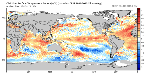 |
| Figure 3: Current SST anomalies – source Tropical Tidbits https://www.tropicaltidbits.com/analysis/ocean/cdas-sflux_ssta_global_1.png |
The MJO has lost steam over the past 2 weeks with the moderate phase 7 coming down to weak to barely discernible at all. We should see the MJO regather in phases 3-4 and then 5 as we move into March which runs in line with expectations from 2 weeks ago, helping set up renewed tropical moisture surges into our country as well as another monsoon onset.
The SAM has been positive for a week or two after a brief blip negative to neutral prior that. We should see the index drop back to neutral and potentially negative values as some strong lows move to the south causing the highs to shift north which will come after most of the heat has drained out of WA when TC Lincoln makes its final landfall. Broadly, we should see more positive SAM through 2024 allowing that tropical moisture to wrap into many significant systems, such as cut off lows with NW cloudbands ahead of them.
Districts:
Eyre Peninsula
Cooler air behind change early 23rd delivering light coastal showers in the morning, otherwise fine. New ridge pushing in quickly and moving east with warm to hot conditions ahead of another weak change on 25th. Second ridge moving east once more allowing a return to hot to very hot conditions by the 27th. Low pressure system extending from west on 27th with temperatures in the low to mid 40’s over the district and likely high 40’s towards the western Eyre Peninsula and West Coast and certainly the Far West Coast. Very hot at first with freshening N to NW winds on 28th resulting in extreme fire danger ahead of cooler change with little to no rainfall. Temperatures in the low 40’s ahead of the change, but potentially mid 40’s at least across the NE and N of the Peninsula, especially so if the change is late. If change is early then likely only mid 30’s before cooling right down. Rainfall for period, less than 0.4mm about the Lower Eyre Peninsula.
Upper North
Cooler air behind a weak change early 23rd delivering cloudy conditions in the morning, otherwise fine. New ridge pushing in quickly and moving east with warm to hot conditions ahead of another weak change on 25th. Second ridge moving east once more allowing a return to hot to very hot conditions by the 27th. Low pressure system extending from west on 27th with temperatures in the high 30’s to near 40C over the district. Very hot with freshening N to NW winds on 28th resulting in extreme fire danger ahead of cooler change late in the day with little to no rainfall. Temperatures in the low to mid 40’s ahead of the change, but potentially mid to high 40’s towards Port Augusta especially so if the change is late. If change is early, then likely only high 30’s to low 40’s. Rainfall for period, immeasurable trace at best.
Lower North
Cooler air behind a weak change early 23rd delivering cloudy conditions with a light shower about the southern slopes in the morning, otherwise fine. New ridge pushing in quickly and moving east with warm to hot conditions ahead of another weak change on 25th. Second ridge moving east once more allowing a return to hot conditions by the 27th. Low pressure system extending from west on 27th with temperatures in the high 30’s over the district. Very hot with freshening N to NW winds on 28th resulting in extreme to potentially catastrophic fire danger ahead of cooler change in the afternoon the day with little to no rainfall. Temperatures in the low 40’s ahead of the change. If the change is early then likely only mid to high 30’s. Rainfall for period, immeasurable trace at best.
Yorke Peninsula
Cooler air behind a weak change early 23rd delivering cloudy conditions with a light shower about the foot during the morning, otherwise fine. New ridge pushing in quickly and moving east with warm to hot conditions ahead of another weak change on 25th. Second ridge moving east once more allowing a return to hot conditions by the 27th. Low pressure system extending from west on 27th with temperatures in the high 30’s over the district. Very hot with freshening N to NW winds on 28th resulting in extreme to potentially catastrophic fire danger ahead of cooler change in the early afternoon with little to no rainfall. Temperatures in the low to mid 40’s ahead of the change. If the change is early then likely only mid to high 30’s. Rainfall for period, less than 0.4mm about the foot.
Kangaroo Island
Cooler air behind a weak change early 23rd delivering cloudy conditions with a few light showers during the morning, otherwise fine. New ridge pushing in quickly and moving east with warm conditions ahead of another weak change on 25th. Second ridge moving east once more allowing a return to warm to hot conditions by the 27th. Low pressure system extending from west on 27th with temperatures in the low to mid 30’s over the district. Hot to potentially very hot with freshening N to NW winds on 28th resulting in extreme fire danger ahead of cooler change in the late morning or early afternoon with little to no rainfall. Temperatures in the mid to high 30’s ahead of the change. If the change is early then likely only low 30’s. Rainfall for period, less than 0.6mm.
Adelaide Plains
Cooler air behind a weak change early 23rd delivering cloudy conditions with a light shower about the southern suburbs during the morning, otherwise fine. New ridge pushing in quickly and moving east with warm to hot conditions ahead of another weak change on 25th. Second ridge moving east once more allowing a return to hot conditions by the 27th. Low pressure system extending from west on 27th with temperatures in the high 30’s over the district. Very hot with freshening N to NW winds on 28th resulting in extreme fire danger ahead of cooler change in the afternoon with little to no rainfall. Temperatures in the high 30’s to 40’s ahead of the change. If the change is early then likely only mid to high 30’s. Rainfall for period, less than 0.2mm about the southern suburbs.
Mt.Lofty Ranges
Cooler air behind a weak change early 23rd delivering cloudy conditions with a few light showers about the southern coasts and ranges during the morning, otherwise fine. New ridge pushing in quickly and moving east with warm to hot conditions ahead of another weak change on 25th. Second ridge moving east once more allowing a return to hot conditions by the 27th. Low pressure system extending from west on 27th with temperatures in the mid 30’s over the district. Very hot with freshening N to NW winds on 28th resulting in extreme to potentially catastrophic fire danger ahead of cooler change in the afternoon with little to no rainfall. Temperatures in the high 30’s to near 40C ahead of the change. If the change is early then likely only mid to high 30’s. Rainfall for period, less than 1mm about the Southern coasts and ranges.
Riverland/Mallee
Cooler air behind a weak change early 23rd delivering cloudy conditions in the morning, with a light shower or two possible about the SW Mallee otherwise fine. New ridge pushing in quickly and moving east with warm to hot conditions ahead of another weak change on 25th. Second ridge moving east once more allowing a return to hot to very hot conditions by the 27th. Low pressure system extending from west on 27th with temperatures in the high 30’s to near 40C over the district, especially the Riverland. Very hot with freshening N to NW winds on 28th resulting in extreme fire danger ahead of cooler change late in the day with little to no rainfall. Temperatures in the low to mid 40’s ahead of the change, but potentially mid to high 40’s towards the N/NE Riverland especially so if the change is late. If change is early, then likely only high 30’s to low 40’s. Rainfall for period, immeasurable trace at best.
Upper SE
Cooler air behind a weak change early 23rd delivering cloudy conditions in the morning, with a light shower or two possible early otherwise fine. New ridge pushing in quickly and moving east with warm to hot conditions ahead of another weak change on 25th. Second ridge moving east once more allowing a return to hot to very hot conditions by the 27th. Low pressure system extending from west on 27th with temperatures in the high 30’s over the district, especially in the north. Very hot with freshening N to NW winds on 28th resulting in extreme fire danger ahead of cooler change late in the day with little to no rainfall. Temperatures in the low 40’s ahead of the change, but potentially mid 40’s towards the far N if the change is late. If change is early, then likely only high 30’s. Rainfall for period, less than 0.4mm.
Lower SE
Cooler air behind a weak change early 23rd delivering cloudy conditions in the morning, with a few light showers, chiefly morning, otherwise fine. New ridge pushing in quickly and moving east with warm conditions ahead of another weak change on 25th. Second ridge moving east once more allowing a return to hot conditions by the 27th. Low pressure system extending from west on 27th with temperatures in the mid high 30’s over the district, especially in the north. Hot to very hot with freshening N to NW winds on 28th resulting in extreme fire danger ahead of cooler change late in the day with little to no rainfall. Temperatures in the high 30’s to near 40C ahead of the change, but potentially low 40’s towards the far N if the change is late. If change is early, then likely only low to mid 30’s. Rainfall for period, less than 0.8mm.
Western VIC
Cooler air behind a weak change early 23rd delivering cloudy conditions in the morning, with a few light showers about the SW District, chiefly morning, otherwise fine. New ridge pushing in quickly and moving east with warm conditions ahead of another weak change on 25th. Second ridge moving east once more allowing a return of warm to hot conditions by the 27th, chiefly about the Wimmera and Mallee. Low pressure system extending from west on 27th with temperatures in the mid high 30’s over the district, chiefly the Mallee and Wimmera once again. Hot to very hot with freshening N to NW winds on 28th resulting in extreme fire danger ahead of cooler change late in the day with little to no rainfall. Temperatures in the high 30’s to near 40C ahead of the change, but potentially low 40’s if the change is late about the SW District and Wimmera and the mid 40’s about the Mallee. If change is early, then likely only mid to high 30’s about the SW District, near 40C about the Wimmera but still low 40’s likely in the Mallee. Rainfall for period, less than 0.8mm about the SW coast. Largely dry inland.
Final Notes
- Dry February through much of the nation to be replaced by much wetter March as the monsoon re-develops, especially for WA and the general tropical areas, with more significant intrusions south, including into SA/VIC
- Uptick in tropical cyclones likely with equal share off WA and QLD but also the greater Pacific
- Negative IOD and La Nina still looking likely right now for the growing season
- Watch the sun, very active currently with significant X class solar flares and likely not the last of them so Jetstream activity may become volatile
- Mid-autumn lull of a shorter duration this year probably mid to late April but a return to a stronger breaking rain signal through May as the Indian shows its hand
- Overall, an above average year looking likely rainfall wise with multiple opportunities for good rain, even deep into the season
Link to temporary blog website: https://farmweathersa.blogspot.com/
Happy Farming and Cheers from The Weatherman
*Note – For interest only, all thoughts are of The Weatherman and may not be reproduced without my consent.
Comments
Post a Comment