February Outlook 2024 SA
February outlook 2024 SA
*Forecast prepared between Jan 31st-Feb 3rd, 2024
Review:
G’Day one and all, February is now here and time to have a look at what is in store for us in the final month of summer, traditionally a hot and dry one for SA, however this year the heat will primarily remain inland with less dips south than the average Feb.
Firstly, as usual, we will have a look back at January and we can certainly say it kicked off 2024 with quite a bang in many districts with both good rain, thunderstorms and decent humidity, not just in SA but across the greater east whilst the Top End and Northern parts of QLD (and to a lesser extent the top of the Kimberly) saw a solid onset of the monsoon.
The main event in the second half of the month for SA was a narrow but well received rainband with heavy convective areas embedded in a training line which largely focused through the Central portions of the Adelaide Metro area with remnant moisture feeding down from the slow moving Monsoonal Low that flooded the Timber Creek regions of the NT before moving into WA and giving much needed rainfall inland. Alas, the SWLD missed out however the moisture from the low fed down along a mid and upper-level Jetstream into SA with decent lift and convergence maximised over Adelaide. Falls of 25-45mm occurred with some flash flooding in the inner southern suburbs. Useful totals also occurred over Lower Eyre Peninsula, Central Yorke Peninsula and into the western parts of the Mallee. I have never seen it this green in late Jan/early February in my time on this earth with consistent rainfall occurring through the warmer months. Consequently, summer weeds are very happy indeed!
Other notable events include of course the crossing of TC Kirrily which, to be honest was nowhere near a category 3, at best maybe a weak 2 but probably a high 1 in the end. Significant rainfall however was the main feature of this system as it crossed but moreso as it moved inland and became slow moving over outback western QLD, stuck between steering influences. The expected heavy rainfall across the interior was just part 1 of many major rain events inland to come in 2024. This one however, really did fall in one of the better zones to maximise floodwaters heading down the Diamantina, Cooper, Georgina and Warburton systems into Lake Eyre. With the 400-700mm falls that have already fallen (some in areas of little to no rain gauges) plus the reversing of the low in the
coming days back down a little further west, the amount of water heading to Lake Eyre will be very significant and a step up on the 2019 floods from Mount Isa etc which were generally further away and didn’t hang around as long, and as a result, had more water absorption along the way.
Finally, I did mention the significant heat potential from the January mid-month update with a focus between the 24th and 26th. We didn’t quite get the 50C, but Birdsville gave it a real crack with 49.4C on the 25th. Marree Airport reached 48.5C on the same day with Oodnadatta and Moomba also both cracking 48C. Some slight mitigation of the airmass as it shot east just took the edge off it as well as the trajectory being more west-east and faster moving. Over WA some new records were set for specific stations, namely Paraburdoo which set records on consecutive days with 47.9C on the 20th which was then beaten with 48.1C on the 21st. Now we have to remember how impressive this is compared to Birdsville, Oodnadatta etc as Paraburdoo sits at a height of 423.7m whereas Birdsville is 46.6m and Oodnadatta 116.5m. Dry air on average cools about 9.8C per km height so taking Birdsville for example at 46.6m we can approximate the equivalent temperature at 46.6m where Paraburdoo is would be around 51.8C. A pretty hot airmass and one that continued to bake a very dry Pilbara and general W/SW part of WA. The persistent dry easterly winds and lack of any moist troughs or fronts or moisture from the north has kept things very dry with the positive SAM the main culprit (helping keep things wet in the east though).
This also highlights if the right setup does occur, that those lower elevations are the ones that are the most likely to set the highest temp records despite not sitting under the main heat engine of Australia (Pilbara). But enough waffle from me on this!
In terms of the rainfall charts, here are the various ones for the month of January:
 |
| Figure 1: January 2024 rainfall deciles – source BoM http://www.bom.gov.au/climate/ |
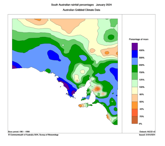 |
| Figure 2: January 2024 rainfall percentages – source BoM http://www.bom.gov.au/climate/ |
 |
| Figure 3: January 2024 rainfall anomalies – source BoM http://www.bom.gov.au/climate/ |
Here is the January outlook that I issued for rainfall:
“Now as for an outlook for January, I do expect average to above average rainfall for most districts. The greatest chance of above average rainfall is the districts east of the border including the Upper and Lower SE, the Mallee and the Riverland and also the Far West/West Coast of the state. The greatest chance of below average rainfall is probably the Far North towards the NT where more upper ridging is likely to be present with significant heat. Most other areas will be average but leaning more towards the above average end.”
Overall, a reasonable effort considering January is one of the harder months to get right (noted by last year's miss!) The bulk of the state received above average rainfall with the right trends as expected with the far west coast and the west coast doing well combined with good falls in the east, especially closer to the border there. The drier trend to the far north under the influence of that
ridging and heat was noticeable enough. A few random dry holes which missed the storms and rain areas across the Lower North, the very tips of the LSE coast and western end of KI, but overall, these dry pockets were very small. It is nice to see good rain in a month that can be incredibly hot and dry in bad years!
Meteorological Discussion:
Onto current events and right now we see a major event still unfolding across the interior of QLD. This is the low associated with Ex TC Kirrily and it continues to bring areas of rain, some heavy at times with flooding as well as isolated to scattered thunderstorms, with intense rainfall rates under these storms. The BoM did not officially name Kirrily for a second time however JTWC (Joint Typhoon Warning Centre) did as it made a small move into the soupy 31C waters of the Gulf of Carpentaria but the agencies both differ in how the systems are classified. I won’t bore you with the details as it was barely back to Cyclone status either way.
From here, the low will drift south down the border of NT/QLD roughly before clipping the far NE corner of SA before traversing from the NW corner of NSW right through the centre towards Canberra before largely dissolving. The re-curve to the SE can be attributed to a large upper trough extending from the west, capturing the low ahead of it before the entire system dissolves within the large upper trough. The very high PWAT (Precipitable Water) content from this Ex Tropical Cyclone will result in areas of moderate to heavy rain from thick Nimbostratus, with the odd isolated embedded thunderstorm further towards the northern edges at times as well. Strong to possibly gale force winds are likely with this system as the circulation remains well intact. This will be a large soaking rain event for some areas that have missed out so far this northern wet season, namely the far NW corner of NSW which is dry and also the very far NE corner of SA, although the very driest part which is SW of Cameron’s Corner may only see moderate totals with the heaviest band going a little to the NE near the tr-state border but there is still time for a slight wiggle SW. In any case, there will be areas of flooding as some of the rain will fall quite quickly causing significant river and stream rises or flash flooding in dry creek/riverbeds and certainly moisten the soil ahead of those main floodwaters coming down the main river systems from further upstream. Rainfall totals generally in the 40-80mm range however there will be some much heavier totals of 100-150mm, especially near the tri-state border of QLD/NSW/SA where convergence will be maximised.
Further south in SA the 4th will be a hot to very hot day, especially inland ahead of a surface trough which will bring a cooler and gusty change in the late afternoon or evening. This trough together with the broad upper trough aloft won’t have any moisture to work with so it will be a largely dry change. Fire dangers will be extreme ahead of it however with some fresh and gusty winds at times. Temperatures are likely to reach the 43-45C range north of Adelaide in many centres and certainly in centres like Port Augusta, Whyalla and Renmark where the change will take a little longer to reach.
Beyond this change, we will see an extended period of ridging across the state where a broad high-pressure system will set up south of the state delivering a steady SE flow across much of the state for a large majority of the period up until mid Feb. There will be some oscillations in the ridging with at least a shallow coastal change pushing back in as the ridge builds back from the west with onshore flow. A front and deeper low as likely to pass to the south of the state and into Southern VIC/Tas around the 12th-14th period with some swell increase and cooler conditions, chiefly about the coast bringing some onshore showers but not a lot in it. After this the next ridge should push east allowing some heat in behind it just after mid-month before that trough extends eastwards.
As far as the rainfall outlook is concerned, I am still expecting a drier month overall as we are in reset mode. The exception of course will be the NE corner of the NE Pastoral which will blow right out to above to very much above average from this rainfall event in the coming 24-48hrs. This also is likely to be the first place recycled moisture pushes back into from the E/NE with spasmodic isolated afternoon thunderstorm activity. Some potential rainfall is likely at the very end of the month or into March, but it is a little tricky to pinpoint. If it is March, then some locations will see no rain for the entire month, but I think something may come just in time. However, despite this, I’m still expecting broadly below average with some very much below average areas in Central/Southern areas tending to average across the very far west of the state.
The broad outlook for through the year has not changed with March/April showing reasonable signs of solid rainfall events with some breaks as we push towards May before a fairly good infeed of moisture begins from the NW through the winter and early spring period at least. I will have a better idea especially of winter/spring in the coming couple of months, but it does look solid enough this year with a better head start than usual.
Climate Drivers:
The Pacific has shown its hand in the last few weeks with a clear breakdown of El Nino occurring. Even though by the book we are still well into El Nino levels, we know that the influence of that has long gone and has been setting up with La Nina moves in the atmosphere ahead of time, driven by the SAM primarily but the Humboldt Current is also starting to show its hand now too plus colder water continues to accumulate at depth in the sub-surface over the equatorial Pacific (See Figure 4). I should also note closer to Australia the recent cold-water upwelling in wake of TC Kirrily, but further south over the Tasman, the very warm seas remain. Once we go back to a Positive SAM, the moisture will pour back into the mainland with a vengeance.
 |
| Figure 4: Sub-surface cross section of Pacific showing colder water anomalies at 100-200m increasing – source BoM http://www.bom.gov.au/climate/enso/wrap-up/archive/20240123.tao_sub_surface.png |
Going forward through 2024, I can only see La Nina, perhaps it may end up a little closer to a La Nina Modoki where the coldest water is a little more central than usual but if the Humboldt Current does its thing, then that should all link up to a classic one. This setup will only exacerbate the strong wet signal we already have.
 |
| Figure 5: Current SST anomalies – source Tropical Tidbits https://www.tropicaltidbits.com/analysis/ocean/cdas-sflux_ssta_global_1.png |
Moving on to the Indian and we see some interesting anomalies appearing here off the NW shelf. I discussed in the last update about the cold-water upwelling off the coast here due to the positive SAM and persistent easterlies. We now also see these colder anomalies extend right up the coast and across the Top End however this northern portion is not for the same reason, but merely the mixing caused by the recent monsoon. The colder water has just spread out and joined up creating the illusion of a giant mass upwelling caused by the same process, but it is not. Now that the monsoon has retreated, we should see some warming occur in these areas. Looking at Figure 6 we can see already that areas further west south of Indonesia have begun to warm back up again after a brief disturbance from the monsoon. This is all normal and happens every year. Now despite all this, the numbers say we are still in a Positive IOD and like the El Nino this is correct with the last reading coming in at +0.64C but the influence of the event on the mainland is long dead and was so once the monsoon formed. Looking ahead, no changes to the outlook with a negative IOD expected in winter/spring, the strength for now looks tricky as warmth will be dominant everywhere but I would expect at a bare minimum a moderate one and likely a moderate to strong.
 |
| Figure 6: 7-Day change in SST anomalies – source Tropical Tidbits https://www.tropicaltidbits.com/analysis/ocean/cdas-sflux_ssta7diff_global_1.png |
The MJO is currently in phase 7 and that is clearly evident by the large amount of convection between New Caledonia and Fiji. The NE trades winds are currently blowing quite hard across the North Pacific, and this will turn across the equator and fuel the MJO to sustain it in this region for a good week or so before it weakens out. There is a chance this may help generate a Tropical Cyclone but given how far east it is, the chance of a threat to Australia in this MJO phase remains small in the short term and it is likely to remain a fish (stay over water). If it doesn’t wander too far east before the new ridging builds under it as the MJO pushes back towards phase 1-2 then we might see it steer west back towards QLD. But I will monitor it closely in any case.
As we move into late Feb and March more so, I expect a more substantial MJO pulse in phases 4-6 to maximise over the Australian continent and help enhance the next burst of tropical rainfall. It also may be the one that helps dent the dry in WA with more gusto but there is a lot of work to do there so it will probably take multiple systems and setups to let that moisture penetrate deeper SW into the state.
The SAM has finally seen a little negative burst, and this has been clear with the increased swells across the south in the past few days. Some rare very good surfing conditions are likely off the south coast of the Fleurieu on the 2nd and 3rd. I expect the negative burst to be short lived with a relaxing back to neutral levels and then a creep back to positive ones. The next significant positive burst is likely through late Feb and March as moisture really builds from persistent easterlies which will be blowing across very warm SSTs off Eastern Australia (28C SE of Brisbane). I should also note with these warmer seas here that any Tropical Cyclones are likely to have more sustainment further south than usual putting places such as SE QLD at risk SHOULD one enter that region AND steering be favourable for a crossing (lots of boxes to tick).
Districts:
(Adding NE Pastoral for this event, and will add them when events line up as needed for now. Once subscription service is up and running then both NW and NE will have their own section like the rest of the state)
NE Pastoral
Becoming humid on 4th with areas of rain, heavy at times extending from the N across the NE corner of the district as a deep low associated with Ex TC Kirrily moves SSE. Isolated embedded thunderstorms possible closer to the QLD border. Strong to gale force winds, possibly damaging at times closer to the low centre from late evening on 4th to early hours of 5th. Flooding likely in some locations with significant stream and river rises from dry beds, with flash flooding also possible. Heavy rain clearing early on 5th as the low moves into NSW but humid conditions prevailing in the wake for a day or two. New ridging further south will bring drier air in after this. Isolated thunderstorms possible around 11th-12th onwards about the NE corner as moisture feeds back in from QLD into a trough. Rainfall for period: 40-80mm within the core of the rainband across the NE corner with scattered totals to 100mm and isolated 150mm falls possible near the tri state border or just over it into NSW/QLD. The remainder of the district located SW of this band (majority) will be decreasing totals of 0.2-2mm with many locations in the far W/SW towards the NW Pastoral border remaining dry.
Eyre Peninsula
Hot to very hot with temps nearing 42C in the north on 4th with freshening N-NW winds and very high fire to extreme fire danger ahead of a trough bringing a cooler, gusty SW-S change during the afternoon, earlier about Lower Eyre Peninsula. Winds may be strong at times about exposed coasts during the afternoon behind the change. Slight chance of a mid-level shower with and after change. New ridging below the state with a dominant SE flow over coming days combined with afternoon seabreezes resulting in fine to mild and warm and mostly dry conditions. Becoming hot again by about 12th or so ahead of a trough with another cooler change followed by a new ridge into the mid-month period. Rainfall for period less than 0.4mm, perhaps only extreme southern coastal areas may see some very light sprinkles.
Upper North
Very hot with temps to near 45C in the north on 4th with freshening N-NW winds and extreme fire danger ahead of a trough bringing a cooler, gusty SW-S change during the late afternoon and early evening. Winds may be strong at times about exposed gulf coasts during the evening behind the change. Possible patchy light rain in far N of district over the Flinders but not a lot in it. New ridging below the state with a dominant SE flow over coming days combined with afternoon seabreezes resulting in fine to mild and warm and mostly dry conditions. Gully winds at times on western slopes overnight. Becoming hot again by about 12th or so ahead of a trough with another cooler change followed by a new ridge into the mid-month period. Rainfall for period less than 0.2-0.4mm, perhaps only 1-2mm possibly over the far NE corner of the district in the Flinders.
Lower North
Very hot with temps to near 43C in the south/SW on 4th with freshening N-NW winds and extreme fire danger ahead of a trough bringing a cooler, gusty SW-S change during the late afternoon and early evening. Winds may be strong at times about exposed gulf coasts during the evening behind the change. Slight chance of a mid-level shower with and after change. New ridging below the state with a dominant SE flow over coming days combined with afternoon seabreezes resulting in fine to mild and warm and mostly dry conditions. Gully winds at times on western slopes overnight. Becoming hot again by about 12th or so ahead of a trough with another cooler change followed by a new ridge into the mid-month period. Rainfall for period less than 0.2-0.4mm and generally dry for most locations.
Yorke Peninsula
Very hot with temps to near 42C in the north on 4th with freshening N-NW winds and extreme fire danger ahead of a trough bringing a cooler, gusty SW-S change during the mid-afternoon. Winds may be strong at times about exposed gulf coasts during the evening behind the change. Slight chance of a mid-level shower with and after change. New ridging below the state with a dominant SE flow over coming days combined with afternoon seabreezes resulting in fine to mild and warm and mostly dry conditions. Becoming hot again by about 12th or so ahead of a trough with another cooler change followed by a new ridge into the mid-month period. Rainfall for period less than 0.2-0.4mm and generally dry for most locations.
Kangaroo Island
Warm to hot with temps to near to around 33C about the centre of the island on 4th with freshening N-NW winds and high to very high fire danger ahead of a trough bringing a cooler, gusty SW-S change during the early-afternoon. Winds may be strong at times about exposed gulf coasts during the evening behind the change. Slight chance of a mid-level shower with and after change. New ridging below the state with a dominant SE flow over coming days combined with afternoon seabreezes resulting in fine to mild and warm and mostly dry conditions. Becoming warm to hot again by about 12th or so ahead of a trough with another cooler change with some light coastal showers followed by a new ridge into the mid-month period. Rainfall for period less than 0.2-1mm and generally dry for many locations.
Adelaide Plains
Very hot with temps to near 43C in the outer northern plains on 4th with freshening N-NW winds and extreme fire danger ahead of a trough bringing a cooler, gusty SW-S change during the late afternoon. Winds may be strong at times about exposed gulf coasts during the evening behind the change. Slight chance of a mid-level shower with and after change. New ridging below the state with a dominant SE flow over coming days combined with afternoon seabreezes resulting in fine to mild and warm and mostly dry conditions. Gully winds at times on western slopes overnight, strong at times about southern ranges and suburbs. Becoming hot again by about 12th or so ahead of a trough with another cooler change followed by a new ridge into the mid-month period. Rainfall for period less than 0.2-0.4mm and generally dry for most locations.
Mt.Lofty Ranges
Very hot with temps to near 40C about the Barossa on 4th with freshening N-NW winds and extreme fire danger ahead of a trough bringing a cooler, gusty SW-S change during the late afternoon. Winds may be strong at times about exposed slopes/peaks and southern coasts during the evening behind the change. Slight chance of a mid-level shower with and after change. New ridging below the state with a dominant SE flow over coming days combined with afternoon seabreezes resulting in fine to mild and warm and mostly dry conditions. Gully winds at times on western slopes overnight, strong at times about southern ranges. Becoming hot again by about 12th or so ahead of a trough with another cooler change followed by a new ridge into the mid-month period. Rainfall for period less than 0.2-0.4mm and generally dry for most locations.
Riverland/Mallee
Very hot with temps to near 44C about the N Riverland on 4th with freshening N-NW winds and extreme fire danger ahead of a trough bringing a cooler, gusty SW-S change during the early evening about the Mallee and late evening about the Riverland. Winds may be fresh to strong at times during the evening behind the change, chiefly closer to the Lakes in the far SW of the Mallee. Slight chance of a mid-level shower with and after change. New ridging below the state with a dominant SE flow over coming days combined with afternoon seabreezes about the SW Mallee resulting in fine to mild and warm and mostly dry conditions. Becoming hot again by about 12th or so ahead of a trough with another cooler change followed by a new ridge into the mid-month period. Rainfall for period less than 0.2-0.4mm and generally dry for most locations.
Upper SE
Hot to very hot with temps to near 40C about the N of the district on 4th with freshening N-NW winds and extreme fire danger ahead of a trough bringing a cooler, gusty SW-S change during the early evening. Winds may be fresh to strong at times during the evening behind the change, chiefly closer to the Lakes in the far NW and about the Coorong coastline. Slight chance of a mid-level shower with and after change. New ridging below the state with a dominant SE flow over coming days combined with afternoon seabreezes resulting in fine to mild and warm and mostly dry conditions. Becoming hot again by about 12th or so ahead of a trough with another cooler change followed by a new ridge into the mid-month period. Rainfall for period less than 0.2-0.4mm and generally dry for most locations.
Lower SE
Warm to hot with temps to near 34C about the N of the district on 4th with freshening N-NW winds and very high fire danger ahead of a trough bringing a cooler, gusty SW-S change during the early evening. Winds may be strong at times during the evening behind the change, chiefly closer to the coastline. Slight chance of a mid-level shower with and after change as well as some isolated light onshore showers or drizzle. New ridging below the state with a dominant SE flow over coming days
combined with afternoon seabreezes resulting in fine to mild and warm and mostly dry conditions. Becoming hot again by about 12th or so ahead of a trough with another cooler change followed by a new ridge into the mid-month period. Rainfall for period less than 0.2-1mm and generally dry for most locations.
Western VIC
Hot to very hot with temps ranging from up to 37-38C about the N of the SW District to 44C about the N Mallee on 4th with freshening N-NW winds and extreme fire danger ahead of a trough bringing a cooler, gusty SW-S change during the early evening over the SW District before reaching the Mallee closer to midnight. Winds may be fresh to strong at times during the evening behind the change, chiefly closer to the coastline of the SW District. Slight chance of a mid-level shower with and after change with onshore light shower activity possible about the SW coastline. New ridging below the state with a dominant SE flow over coming days combined with afternoon seabreezes resulting in fine to mild and warm and mostly dry conditions. Becoming hot again by about 13th or so ahead of a trough or front with a large low to the south bringing another cooler change with shower activity in the south followed by a new ridge into the mid-month period. Rainfall for period less than 1-2mm about the coastline and generally dry for most locations inland.
Final Notes
- Heavy rain with flooding about NE corner on 4th-5th from EX TC Kirrily
- Lull in general wetter conditions as the reset occurs thanks to brief negative SAM period
- Resumption of wetter conditions from March with significant events likely, including inland flooding well into autumn
- La Nina and Negative IOD combination the most likely through winter and spring enhancing wetter conditions through the growing season
- Usual brief autumn lull after inland rains most likely in April to early May before NW moisture pushes down ahead of winter longwaves
- Watch for active Pacific cyclone season with warmer water dominating
Link to temporary blog website: https://farmweathersa.blogspot.com/
Happy Farming and Cheers from The Weatherman
*Note – For interest only, all thoughts are of The Weatherman and may not be reproduced without my consent.


Comments
Post a Comment