December update 2023 SA
December update 2023 SA
*Forecast prepared between Dec 18th-21st 2023
Review:
G’Day one and all, the last update for 2023 is here unless we get some significant events before the month comes to a close. I’ll get right into it as the first half of this month certainly has brought a very major event, one I said would be remembered for many years to come and that will definitely be the case, it took me right back to December 1992 on my memory bank when I was only a wee tacker in early primary school.
The main point of discussion of course was the thumping, slow-moving cut off upper low that dominated the weather across the agricultural areas and adjacent interior for much of the period from December 9-12th with rain, showers and multiple thunderstorms, many forming in trains with one after another passing over the same area, all in all came off as expected with no surprises. I unfortunately did not get time to pop out another update for the more thundery conditions that were expected Mon 11th and Tues 12th due to being called into work twice in a row. It all began with a large and long-lived rainband moving NW-SE along a mid to upper level jetstream which formed from the lift on the eastern side of a very large upper-level trough. Given this was positively tilted (sloped back west with northern extent), it had a lot more time to keep the rain going over the same area. Solid rainfall of 30-50mm occurred within this band with some locations receiving continuous rain for over 24hrs which is impressive for any month of the year. The moisture origins were from the N portions of WA after moisture travelled west across the Top End and then down into the interior before finally moving SE. Note that the cloudband kept to the SW of the strong mid-level ridge over the east coast as that is where the jetstream is located, rounding the area above the upper trough and below the upper ridge. Cloudbands will always do this, the left side over time will bow out under the baroclinic leaf to the west closer to the colder air aloft from the upper trough. The eastern side will go under the upper ridge before following the jetstream. In this case this ran all the way along to New Zealand.
As the upper low developed the new cloudband started to add to the old with a fatter shape taking place as massive upper divergence occurred aloft to the east of the cold, dry air which was the upper low to the west allowing a powerful mid-level jetstream to develop. Long-lived isentropic lift occurred here with rain, showers and isolated thunderstorms continuously forming. Through the early hours of the 11th, we saw the rainband move further SW with very strong and gusty low-level winds forming beneath a deepening surface low. This low-level jet caused enhanced gully winds across the Adelaide area which caused damage, with trees and branches coming down and gusts to near 100km/hr. Mid-level thunderstorms then formed before sunrise with this enhanced low-level convergence and lift with this activity streaming southwards all day in a band of thunderstorms, tending to thundery rain at times. Through the evening off 11th and early 12th, the convergence shifted west with numerous thunderstorms rolling down from the Lower and Upper North down through Yorke Peninsula but less further east. The final blow from the system was further thunderstorm activity on the 12th but this mostly cleared by the late afternoon as the entire forcing mechanisms began to weaken. But this certainly was a very long and sustained area of convergence with significant rainfall, perhaps slightly more than initially thought over metropolitan Adelaide. The real extreme 200+ totals didn’t quite occur over Eyre Peninsula however 125-150mm falls did occur and perhaps there may have been higher but I have not seen or heard of these. A lot of very good rainfall putting moisture down deep for 2024 but a disruption for those that still have no finished the harvest, mostly those in the east and SE now.
Meteorological Discussion:
Now what does the rest of December hold? The unique part of this month is the incredible rainfall from ex TC Jasper across Far Nth QLD with some stations recording over 2000mm for the event and the rain is still coming down, albeit more isolated now. Devastating flooding and rockfalls/mudslides down the mountainous terrain have occurred. So, despite a below average Coral Sea, we still have this impact, and it can all be pinned down to sustained convergence. That is all it takes in the tropics for these sorts of events as the moisture loading is always there at this time of the year.
With all that being said, the remnant circulation of Ex Jasper is over the Gulf of Carpentaria roughly east of Gove, but it is a very loose circulation. It is continuing to feed moisture back down through the eastern states with areas of heavy rain, showers and thunderstorms to be captured by an upper trough over the next couple of days. This is likely to cause some flooding in these regions but nothing remotely like Far Nth QLD.
In SA however we have seen a much more settled pattern emerge with a ridge of high pressure largely steering the ship. The troughing in the east however is tightening the gradient so atm we have fairly fresh SE winds and stiff seabreezes at times as well as fresh gully winds. A weak trough will pass across the state on the 23rd with some mid-level showers and perhaps some isolated high based thunderstorms across the interior. I expect this SE prevailing flow to continue right through to Christmas but with a bit of a trump card. That is yet another upper trough pinching off at the top and throwing up an upper low, not to the level of the last two and nor will it be in the same position but at this stage it looks to be further east over the very SE corner of SA and much of VIC. This upper low
should interact with the quasi-stationary easterly dip/trough over the eastern states to deepen it and cause a low to form somewhere near the SA/VIC border, potentially around the Lower SE. The size, strength and location is very much up for debate but I expect something and as a result much cooler conditions around Christmas Day than you may be seeing in the forecasts right now plus more wind, it really will be quite nippy at times outside with that breeze. If the low does form a little further west, then we can expect classic wrap around conditions with cool to cold temperatures, squally showers tending to rain and not very pleasant at all (except those that want the rain which would be a Christmas present on its own right there). I think at this stage, a few showers may be in order for the SE corner of the state, more frequent about the Lower SE and more isolated further north and west with mostly cloudy conditions. Temperatures ranging from 15-17C in the LSE corner up to about 25C by the northern and western agricultural areas. I’ll likely have to issue a special update should this system evolve further west than current but that does seem a longshot to me. It also is likely to affect VIC a lot more than SA at this stage with a broader range of weather including thunderstorms on the eastern side of the low.
Beyond Christmas, the pattern at least becomes a little more mobile from the west with a high rapidly dissolving below the state allowing a trough in from the west around the 27th to 28th. Mostly inland isolated showers and thunderstorms with this before a new ridge with a fresh southerly change pushes in from the west. The final chapter of the month sees moisture building across the tropics ready to send south during early to mid-January ahead of the next MJO. I finally expect some of that heat that is trapped over WA to push into SA and further south for the New Year period or just after, it’s been sitting there for a long time with the only main intrusions being brief to the settled areas, the majority has been pushed eastwards across the northern parts of SA and into NW NSW and SW QLD.
Climate Drivers:
The Pacific has not really made any progress towards El Nino getting more strength in the last 2 weeks, and as mentioned before, it seems now as if the El Nino has peaked, December is a time where we often see peaks. But motion has been gathering on this for some time now with the colder Humboldt Current starting up again with greater areas of colder water now accumulating west of South America. The Coral Sea is below average but some of this can be attributed to Jasper churning up the water column as well as increased cloud over the basin. It certainly isn’t hindering rainfall into Far Nth QLD that is for sure with the most phenomenal rainfall over a focused area with major sustained convergence. Waters off the NSW coast are very warm and those north of Australia are warming up too but are as you expect for this time of the year, nothing unusual about the temperatures. I expect the El Nino breakdown to continue with a lot of warming around Australia to occur through the first quarter of 2024. La Nina will then begin to have a good hard crack through the winter and spring months as colder water deeper down starts to shuffle east before surfacing. A watch for this anyway but that is the leading candidate for 2024.
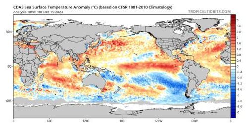
The Indian continues to show a rapid weakening of the once strong Positive IOD. It still is above positive thresholds but due to the weakening, the actual impacts are as close to zero as you get. Apart from that slither off Sumatra and Java, the entire Indian basin is a raging warm soup which will be a breeding ground for moisture loading up cold fronts through autumn/winter in 2024. I am expecting a strong attempt at making a negative IOD to couple with a La Nina, although the Indian is always harder to predict. We will have warmer water near Australia, but I feel just the whole basin will stay fairly warm and we see a neutral to slightly negative IOD. I can’t see a Positive lining up for 2024 however.
The MJO is currently in phase 7 and moving quickly to the east, with this most recent pulse being one of the stronger ones in the past 2 months. It certainly allowed good moisture to feed into the mainland as well as kicking off Jasper. I expect with this motion, the MJO to be entering the Indian again sometime in early January with a weak to maybe moderate pass again to be made at us Mid January. Moisture will build into this period with on ground rainfall impacts over tropics and adjacent inland increasing in the mid to late Jan period. Lingering moisture from Ex Jasper and the heavy QLD rains will persist over QLD with the easterly regime to continue to build moisture across the eastern half especially.
Now the SAM has been a real clincher for us over the past month with a Positive regime (not hugely but slightly) allowing high pressure to sit south with blocking setting up. This blocking causes upper troughs to get pinched off at their northern most point causing upper lows to form, and these upper lows have been driving our wet and thundery weather. We have since seen a lapse back to neutral, so a bit of balance has been restored with some more SW flow coming up. That has also been helped by the MJO pushing into phases 6-7 which naturally breaks up blocks. But we can see a return to this in January should the Pacific jam up again. There are indications of another final cut off over the eastern states (as per discussion) which needs to be watched around Christmas.
Districts:
Eyre Peninsula
High pressure ridge dominating weather causing moderate to fresh SE winds and afternoon seabreezes. Weak trough on 23rd with mid-level showers and a possible thunderstorm, chiefly in the west and north. New ridge pushing in behind before upper trough moves in late 24th with isolated showers developing in the far south. Upper low then forms over VIC for Christmas Day with cooler conditions as S/SE gradient is squeezed. Isolated showers about the Lower Eyre Peninsula contracting and clearing by Boxing Day. Becoming hot ahead of a fast-moving trough or weak low for about 28th with isolated mid-level showers and a possible thunderstorm once again. Ridge across the state keeping conditions mild to warm through till the end of the period with a possible return to hotter conditions into January. Rainfall for the period very low, perhaps 1-2mm at the most, chiefly about the Lower Eyre Peninsula and in the far N/NW with any mid-level showers.
Upper North
High pressure ridge dominating weather causing moderate to fresh SE winds and afternoon seabreezes about the Spencer Gulf. Gully winds at night on western slopes. Weak trough on 23rd with mid-level showers and a possible thunderstorm, chiefly in the north towards the Flinders. New ridge pushing in behind before upper trough moves in late 24th with isolated showers developing in the far south later. Upper low then forms over VIC for Christmas Day with cooler conditions as S/SE gradient is squeezed. Isolated showers possible in the far south about elevated terrain otherwise fine. Any shower activity contracting and clearing by Boxing Day. Becoming hot ahead of a fast-moving trough or weak low for about 28th with isolated mid-level showers and a possible thunderstorm once again. Ridge across the state keeping conditions mild to warm through till the end of the period with a possible return to hotter conditions into January. Rainfall for the period very low, perhaps 1mm with mid-level showers.
Lower North
High pressure ridge dominating weather causing moderate to fresh SE winds and afternoon seabreezes about the Spencer Gulf. Gully winds at night on western slopes. Weak trough on 23rd with isolated mid-level showers, chiefly in the north. New ridge pushing in behind before upper trough moves in late 24th with isolated showers developing, chiefly in the far south. Upper low then forms over VIC for Christmas Day with cooler conditions as S/SE gradient is squeezed. Isolated showers possible, most likely about elevated terrain, otherwise a cool and mostly cloudy day. Any shower activity contracting and clearing by late Boxing Day. Becoming warm to hot ahead of a fast-moving trough or weak low for about 28th with isolated mid-level showers and a possible thunderstorm once again. Ridge across the state keeping conditions mild to warm through till the end of the period with a possible return to hotter conditions into January. Rainfall for the period very low, perhaps 1mm with mid-level showers.
Yorke Peninsula
High pressure ridge dominating weather causing moderate to fresh SE winds and afternoon seabreezes. Weak trough on 23rd with isolated mid-level showers. New ridge pushing in behind before upper trough moves in late 24th with isolated showers extending from the SW. Upper low then forms over VIC for Christmas Day with cooler conditions as S/SE gradient is squeezed with winds fresh at times about the foot and exposed coasts. Isolated showers about the lower half of the Peninsula contracting and clearing by late Boxing Day. Becoming warm to hot ahead of a fast-moving trough or weak low for about late 27th or early 28th with isolated mid-level showers and a possible thunderstorm once again. Ridge across the state keeping conditions mild to warm through till the end of the period with a possible return to hotter conditions into January. Rainfall for the period very low, perhaps 1-3mm at the most, chiefly about the foot of the Peninsula.
Kangaroo Island
High pressure ridge dominating weather causing moderate to fresh SE winds and afternoon seabreezes. Weak trough on 23rd with mid-level showers. New ridge pushing in behind before upper trough moves in early 24th with isolated to scattered showers extending from the SW. Upper low then forms over VIC for Christmas Day with cooler conditions as S/SE gradient is squeezed with winds fresh to possibly strong at times about southern coasts. Isolated to scattered showers contracting and clearing by late Boxing Day. Becoming warm ahead of a fast-moving trough or weak low for about late 27th or early 28th with isolated mid-level showers and a possible thunderstorm once again. Ridge across the state keeping conditions mild to warm through till the end of the period with a possible return to hotter conditions into January. Rainfall for the period 3-8mm, chiefly about the southern coastline.
Adelaide Plains
High pressure ridge dominating weather causing moderate to fresh SE winds and afternoon seabreezes. Gully winds at night on western slopes. Weak trough on 23rd with isolated mid-level showers, chiefly in the north/NE. New ridge pushing in behind before upper trough moves in late 24th with isolated showers extending from the SW. Upper low then forms over VIC for Christmas Day with cooler conditions as S/SE gradient is squeezed. Isolated showers, tending scattered in the far south otherwise a cool and mostly cloudy day. Any shower activity contracting and clearing by late Boxing Day. Becoming warm to hot ahead of a fast-moving trough or weak low for about 28th with isolated mid-level showers and a possible thunderstorm once again. Ridge across the state keeping conditions mild to warm through till the end of the period with a possible return to hotter conditions into January. Rainfall for the period very low, perhaps 1-3mm, tending to possibly 5mm about outer southern suburbs and foothills.
Mt.Lofty Ranges
High pressure ridge dominating weather causing moderate to fresh SE winds and afternoon seabreezes. Gully winds at night on western slopes. Weak trough on 23rd with isolated mid-level showers, chiefly in the north/NE. New ridge pushing in behind before upper trough moves in late 24th with isolated showers extending from the SW, more scattered about windward slopes on the Fleurieu. Upper low then forms over VIC for Christmas Day with cooler conditions as S/SE gradient is squeezed. Isolated to scattered showers, tending frequent about windward slopes and southern coasts of the Fleurieu. Any shower activity contracting and clearing by late Boxing Day. Becoming warm to hot ahead of a fast-moving trough or weak low for about 28th with isolated mid-level showers and a possible thunderstorm once again. Ridge across the state keeping conditions mild to warm through till the end of the period with a possible return to hotter conditions into January. Rainfall for the period 1-4mm however the southern coasts and exposed windward slopes are likely to see 8-15mm potentially with isolated streams to 20mm.
Riverland/Mallee
High pressure ridge dominating weather causing moderate to fresh SE winds and afternoon seabreezes about the Lakes and adjacent surrounds. Weak trough on 23rd with mid-level showers and a possible thunderstorm. New ridge pushing in behind before upper trough moves in late 24th with isolated showers developing in the far south of the Mallee later. Upper low then forms over VIC for Christmas Day with cooler conditions as S/SE gradient is squeezed. Isolated showers possible in the far south of the Mallee and also possible more frequent shower activity towards thew far SE of the Mallee near the VIC border otherwise mostly fine although cloudy. Any shower activity contracting and clearing by Boxing Day. Becoming hot ahead of a fast-moving trough or weak low for about 28th with isolated mid-level showers and a possible thunderstorm once again. Ridge across the state keeping conditions mild to warm through till the end of the period with a possible return to hotter conditions into January. Rainfall for the period very low, perhaps 1mm with mid-level showers tending to 2-4mm in far SE of Mallee with activity from VIC. 1-2mm about the SW Mallee in the moist onshores.
Upper SE
High pressure ridge dominating weather causing moderate to fresh SE winds and afternoon seabreezes about the Coorong and adjacent surrounds. Weak trough on 23rd with mid-level showers and a possible thunderstorm, chiefly in the NE. New ridge pushing in behind before upper trough moves in late 24th with isolated showers developing, potentially more frequent with eastern extent. Upper low then forms over VIC for Christmas Day with cooler conditions as S/SE gradient is squeezed. Isolated showers possible, tending scattered closer to the VIC border, otherwise fine although mostly cloudy. Any shower activity contracting and clearing by late Boxing Day. Becoming warm to hot ahead of a fast-moving trough or weak low for about 28th with isolated mid-level showers and a possible thunderstorm once again. Ridge across the state keeping conditions mild to warm through till the end of the period with a possible return to hotter conditions into January. Rainfall for the period 1-4mm, possibly up to 5-6mm closer to the VIC border.
Lower SE
High pressure ridge dominating weather causing moderate to fresh SE winds and afternoon seabreezes about the coastline. Weak trough on 23rd with mid-level showers. New ridge pushing in behind before upper trough moves in late 24th with isolated showers developing, potentially more frequent with eastern extent. Upper low then forms over VIC for Christmas Day with cooler conditions as S/SE gradient is squeezed. Isolated showers possible, tending scattered closer to the VIC border, otherwise fine although mostly cloudy. Any shower activity contracting and clearing by late Boxing Day. Becoming warm ahead of a fast-moving trough or weak low for about 28th with isolated mid-level showers and a possible thunderstorm once again. Ridge across the state keeping
conditions mild to warm through till the end of the period with a possible return to hotter conditions into January. Rainfall for the period 1-4mm, possibly up to 5-6mm closer to the VIC border.
Western VIC
High pressure ridge dominating weather causing moderate to fresh SE winds and afternoon seabreezes about the coastline. Weak trough on 23rd with mid-level showers and a possible thunderstorm, chiefly over the Mallee District. Deepening surface trough developing across the region with moisture feeding from NE. Upper trough moving up from SW on 24th with scattered showers developing. Isolated afternoon and evening thunderstorms, becoming scattered in the east before activity tends to areas of rain at times. Local heavy falls, chiefly in the east. Upper low lingering through Christmas Day and into Boxing Day with showers and isolated thunderstorms, again more frequent in the eastern portions of the districts with activity much more isolated towards SA. Local heavy falls once again, chiefly in the east. Onshore flow keeping scattered showers going in south and east of SW District before clearing later on 27th. Becoming hot ahead of a fast-moving trough or weak low for about the afternoon of 28th with isolated mid-level showers and a possible thunderstorm once again. Ridge across the state keeping conditions mild to warm through till the end of the period with a possible return to hotter conditions into January. Rainfall for the period 12-25mm generally across the eastern half of the districts, tending to 5-12mm across the western half. Scattered totals to 30-50mm in the east of the SW District with isolated 60-70mm totals possible, chiefly with any thunderstorms.
Final Notes
- Eastwards shift of blocking pattern resulting in upper low interacting with deep troughing over eastern Australia giving showers, thunderstorms and rain areas with local heavy falls.
- Moisture will continue to hold across the eastern half of the continent with a stark contrast to the west where drier and stable conditions will dominate.
- Heat building inland but limited penetration to southern coastal areas for short bursts only
- Weak monsoon onset for Mid-January but poor cross equatorial flow at this stage. Expect a better attempt in Feb and March.
- 2024 outlook remains wet, with multiple periods of good rainfall expected through mid to late autumn and again through early winter and late winter/early spring.
- La Nina and Negative IOD combination possible which will enhance the rainfall.
I hope you all have a very Merry Christmas and a Happy, safe and prosperous 2024.
Link to temporary blog website: https://farmweathersa.blogspot.com/
Happy Farming and Cheers from The Weatherman
*Note – For interest only, all thoughts are of The Weatherman and may not be reproduced without my consent.


Comments
Post a Comment