December Outlook 2023 SA
*Forecast prepared between Dec 3rd-6th 2023
Review:
G’Day everyone, I hope you are keeping well as we now move into summer, a time where most harvest begins to wind up and for some of you that may be the case however, I do know that many are still going, especially those further south and those that have been interrupted by rain and storms which no doubt have thrown a spanner in the works.
Let's get right into the review of November, a month that was a tale of two halves or even less than that with the first part being quite dry before a blocking pattern set up triggering complex systems with wandering upper-level lows.
The first was a cut off upper low that was moderate in strength and dragged in some moisture from the east generating areas of rain mainly but some isolated thunderstorms as well. The main event did come a little earlier than anticipated with cooler low-level temperatures and mid-level cloud causing a drastic drop in instability across many agricultural areas on the 23rd with mid-level Ac/As rainband setting up on the bottom side of the upper low with cool to cold S-SE winds in the lower levels. Some isolated thunderstorm activity still occurred much further north, before cleaner and stronger thunderstorms developed over the northern Eyre Peninsula and Southern NW Pastoral. Rainfall was typically in the 15-25mm bracket but there were isolated heavier falls across parts of the Mallee and certainly the SE Districts. The main sticking point however was the lack of rainfall across Kangaroo Island on the pivot where the mid-level cloudband simply dried out, despite being on the pivot where the rain lingers longer.
The main impacts from this system however was from early 24th and then again later that afternoon and evening where the surface trough focused severe thunderstorms with flash flooding caused by locally intense rainfall. Naracoorte and surrounds was hit particularly hard with 46.4mm to 9am on the 24th followed by 71.4mm to 9am on the 25th which much of that falling in one hour in a slow moving thunderstorm on the afternoon/evening of the 24th. Unfortunately, many crops here were essentially under water which that direct hit. Hail did occur in some storms but chiefly further north where the mid-levels were colder.
The next system however was the main event for most areas and it was a classic case of a rare, small-scale setup which was very sharp, fresh and focused. These setups in my experience deliver very active thunderstorms. The last one I remember like this was January 19/20 2005, very much the same vein, but less rainfall although more thunder/lightning than the most recent one. The upper low and surface trough combined very well with a continuous convergence zone of showers and thunderstorms, eventually congealing more to thundery rain by daybreak and really channelling down across the Mt.Lofty Ranges and Adelaide Metro with flash flooding. Many other adjacent agricultural areas also received some localised flooding with rainfalls in the 30-50mm bracket. I received 56.4mm in southern Adelaide which was a record since I built back in 2013.
Now moving on to the rainfall for the month as well as both spring and the growing season we can see a few clear trends.
Starting with November, it was a month of contrasting, dry for the first 2/3rds and a wet finish, especially so in the Central and Eastern parts of the state. Rainfall varied considerably from below average to very much below average across the Eyre Peninsula (except a small pocket of the East) and West Coast Districts to above to very much above average over the Adelaide area and western portions of both the Riverland and Mallee. The latter of this can be attributed to the rare reverse orographic ascent onto the back side of the ranges from the E and NE (of course traditionally the wetter side is on the west of the ranges). Kangaroo Island also suffered from below to very much below average rainfall. Parts of the NW Pastoral were above average. The intense upper low and surface trough with showers and thunderstorms tending to heavy rain at times did the rest for the Central areas and again just behind the ranges with a double up of solid activity. Before these systems there was less than 1mm for most locations! How things can change quickly with some thundery dumps.
Now taking a look back at the November outlook:
“Overall, the monthly rainfall outlook for November continues to see below average rainfall but the signatures will not be as widespread as October. Areas that should do better closer to average include the NE corner of the state from the easterly dip as well as the NW and far west with influence from the WA heat trough thunderstorm activity. Most other remaining districts should see below average rainfall with again some very much below average totals over some southern agricultural districts including the Mt.Lofty Ranges, Yorke Peninsula, Kangaroo Island and the SE Districts."
It’s a bit of a dog's breakfast when you look at the rainfall percentages in Figure 2 with above and below average quite close together. Kangaroo Island was the best performed area but the SE Districts had both well above and below splitting the district with that extra intense fall around Naracoorte. The worst performed was the Mallee and Riverland where falls really did kick above average and generally only average to below average was expected. The NW Pastoral and Far West came out close to expectations as did the drier Eyre Peninsula (apart from the east). All in all, a very mixed result and largely attributed to the thunderstorms. I didn’t quite expect the thunderstorms to be as wet as they were, this was more expected from December onwards. The challenges of spring forecasting!


Figure 5: September-October 2023 rainfall – source BoM http://www.bom.gov.au/climate/
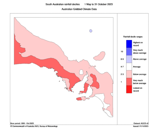
Figure 6: May-October 2023 growing season rainfall – source BoM http://www.bom.gov.au/climate/
Now the clear take home message from Figures 4,5 & 6 is that spring was dry across the state. Infact up until the rain arrived on November 23rd, the entire mainland Australia was on track for its driest spring in history – something that has been overlooked by many when you read about floods and the like on social media. November as a whole was nothing special rain wise, there certainly have been far wetter Novembers both in SA and over the nation. Only very isolated areas caught in those thunderstorms such as Naracoorte and also near Deniliquin in NSW can feel that they had a seriously wet month. For the most part in those figures above, the Positive IOD was largely responsible for our dry spring with significant downwelling and a starving of moisture into frontal systems and troughs. The systems we did have were fast moving, lacked dynamic triggering and had no blocking to allows moisture to build and be pulled down into the systems. Things are changing now however in a major way and that is what I will expand on next.
Meteorological Discussion:
On to current events now and at the moment we have had a bit of a lull after the vigrouous upper low that rounded out November. The thing is though is that broad troughing has still been present inland to the north and NE of us with some re-circulated moisture pushing back into SA causing light showers and drizzle periods at times, chiefly on the back side of the ranges and also into the Mallee and adjacent areas east of the ranges. This added a slightly dampish angle at times to those wishing to dry their crops out to continue harvest.
The 3 main talking points for this discussion is the blocking pattern and easterly regime, the new Tropical Cyclone Jasper in the Coral Sea and the expected strong upper low over SA causing a multi-day rain event with significant falls and flooding. Thunderstorms to finish the event mostly in the eastern portions of the agricultural areas.
Firstly, we will discuss this blocking pattern and what a stubborn one it is at that. The constant blockade upstream over the Tasman Sea and into the Pacific well beyond New Zealand has had a concertina effect of the pattern to the west causing the jetstreams to become very meridional with numerous cut off lows aloft forming because they have nowhere to go. It is in essence a little bit like a Northern Hemispheric pattern. The pattern reminds me of two analogue months/years. One is December 2004 and the second is December 1992. Both may make farmers that haven’t finished harvest shudder however those that have will no doubt welcome to increased rainfall potential from it.
With this block in place, every upper trough attached to the westerly belt that passes below the mainland has a greater chance of being pinched off at the top end and forming a cut off upper low (best analysed on the 500hpa chart). Whilst predicting the movement of these is a struggle at times, they always deliver good rainfall and sometimes, multiple days of thunderstorms in the attached surface trough east of the upper low. With the meridional jetstream, the reach and pull from the tropics is enhanced and right now we have a moderate strength MJO passing across the Top End of the nation – perfect timing to maximise rainfall. So, in short, we have a blocking pattern which has a dominant easterly flow in the low levels turning N to NW with height which is called deterioration shear. It’s like putting a turbo onto your car, you’ve just got a head start on the standard (see Figure 7 below for a visual of the block, better known as an omega block. Infact it actually shows a double omega block which is impressive). I could have even zoomed out further to show a third cut off low well across the Pacific making it a triple omega block. One hell of a traffic jam.

The second part of this discussion involves our first Tropical Cyclone of the season (not including the ones named by Fiji earlier). Tropical Cyclone Jasper has formed and will be steered by a mid-level subtropical ridge (STR) towards the SW. Traditionally at least 8 out of 10 Coral Sea systems will head to the graveyard, that is the waters north of New Zealand and away from Australia, usually due to being captured by a large upper trough. However, this time, the block has allowed the STR to hold firm and this will drive the system ashore in QLD as a high-end category 2 or category 3 TC. Where is very tricky but at this stage somewhere near Townsville or south of seems possible. Ocean heat content is good as is wind shear for now which should allow Jasper to max out as a mid-range cat 4 before less favourable conditions and increasing wind shear closer to the coast cause a weakening. Often, very small systems can undergo Rapid Intensification (RI) close to the coastline but being a larger system, as well as the shear, Jasper us unlikely to do so.
Aside from the coastal impact which will no doubt cause damage and flooding, the main interest for us is the moisture that will be driven inland as the circulation is likely to be pulled well SW towards the upper low and driven by that mid-level STR. Inland rain as well as showers and thunderstorms should get a kick from this but should the upper low start to move east a day or two earlier than current then the inland penetration of this high end tropical air will be short lived.
The third point of discussion is the mentioned upper low and major rain event to develop over SA. This has the hallmarks of being one of the most significant rain events of the last 10 years and is likely to be one that is looked back on in years to come for those areas that do maximise the potential out of it. Powerful dynamics will be at play, despite only modest levels of tropical air (Precipitable Waters around 35-45mm). The key take home points from this is the longevity of rainfall over a particular point with a long and sustained pivot and retrograde of the system combining with powerful upper dynamics interacting with low to mid-level convergence.
Now currently we have a weak surface trough across the state which has been and will continue to produce some light mid-level showers through the 6th and 7th. Rainfall won’t be too significant. Isolated high based thunderstorms are also possible but overall, very insignificant.
By the 8th a stronger surface trough will push in from the west which increase the chances of some mid-level showers and isolated thunderstorms through the agricultural areas, beginning out over the West Coast and extending SE. There will be significant heat to the north/NE of this trough with temperatures reaching the mid to high 40’s across the Pastoral areas, Northern Eyre Peninsula and down to the Iron Triangle and parts of the Upper North that are low lying with many high 30’s and low 40’s south of these areas too. Strong and gusty N-NW winds are likely ahead of the trough across much of the agricultural areas and with any shower or thunderstorm activity which will make for extreme to catastrophic fire danger potential. Lightning will also enhance this so please take heed with likely warnings and fire bans in place.
Further west, an amplifying positively tilted upper trough will increase upper divergence and lift through the evening of the 8th and into the 9th with increasing showers and isolated thunderstorms, tending to patchy rain areas with the odd rumble in between.
As we move through the day on the 9th the strong upper trough will continue to approach but start to pinch off from the westerly belt due to the blocking upstream and start to turn into an upper low. The patchy rain areas will thicken and turn into a general rainband heading NW-SE with moderate to heavy falls beginning to develop. To the east of this, a surface trough will also deepen and enhance low level convergence east of the lifting from the upper low resulting in a powerful upslide environment with Isentropic lift maximised in this area.
On the 10th the upper low will begin to fall over at the top side and become circular in nature and thus become completely independent of the westerly and steering flow. The rainband will begin to pivot as a baroclinic leaf forms on the rear side of it. This is where the rain begins to start bowing out or pulling back SW around the upper low and change shape. Areas under and just north of this pivot will see the maximised lift and convergence and thus the heaviest rainfall from the system where solid moderate to heavy rain with perhaps an embedded rumble or two will occur. This rainfall will likely cause some flooding, and at this stage the most likely area is over N-NE Eyre Peninsula and up to the Southern NW Pastoral to possibly the western portions of the Lower and Upper North, Northern Yorke Peninsula or down the Spencer Gulf. I will refine the locations as we close in on the event.
Isolated thunderstorms are likely to feed into the NE/N portions of the rain area before adding to the rainband further SW as it wraps down under the upper low.
By the 11th, a surface low should form over or near the Eyre Peninsula before getting flung westwards by a strong low level jetstream wrapping under it. Strong and gusty SE-E winds will occur anywhere south of the low but also in the development phase in the prior 24 or so hours, potentially enhanced on western slopes of the ranges. The system as a whole will ‘stretch’ west and east with a surface trough splaying eastwards allowing a dry slot and weak ridge to cut in between the low and the trough causing the rain areas to shoot west offshore around the bottom of the low. Isolated showers and thunderstorms will mark the surface trough which is likely to be located well east of the ranges extending down into the SE districts where instability will be present.
Beyond this, the surface trough will continue to fire showers and isolated thunderstorms along it in the east and SE before this contracts eastwards out of the state. The low to the west will weaken and start to sink back SE-E as the upper low too heads this direction and begins to get re-captured by the westerly belt which will accelerate the system away from us. Showery conditions are likely in a cooler moist flow closer to the low centre as it passes over the southern coastal portions of the agricultural areas, most likely at this stage on the 13th.
After a brief clearance another trough and cold front is likely to rush in from the west with scattered showers and isolated thunderstorms somewhere around mid-month. This SW flow will be the start (but not the big one we need) of the breakdown of this block.
The remainder of December should see a slight easing in the blocking and thus more standard conditions can be expected. I do however see another uptick and moisture build very late December which may filter back our way then or early in January. The signs are there for more humid airmasses to begin their move southwards in January and February but mixed with typical warm to hot summer conditions. Thus, thunderstorm activity will be expected, but especially across the interior of the state.
Overall, the outlook for December is above average rainfall for many agricultural areas, perhaps only the far eastern and SE Districts will be closer to average. Those that become affected by the main band from this event will see very much above average to near record rainfall for the month which is likely to be in that NE/NE Eyre Peninsula and Southern NW Pastoral region. The Mallee and Riverland should come out closer to average, but trending wetter towards the ranges. The far NE Pastoral may see slightly below average rainfall as well as the Far West. *I should note that the validity of this forecast has less weight due to being made a few days into the month*
Climate Drivers:
Taking a look at the Pacific and we can clearly see the El Nino has failed to make any ground since the last update. I suspect for the most part we have peaked or are very close to a peak (watching one last MJO burst that is coming). There has been a notable increase in cooler waters off Chile and the broader southern portion of the Eastern Pacific. This will assist in re-starting the Humboldt Current as high pressure becomes stronger across this colder water. That process will take some time, but this is the early stages setting up. The waters around Australia in general are warming and this includes the Coral Sea which will see a significant Tropical Cyclone in the next week.

Moving over to the Indian and we have a waning Positive IOD, still well and truly in positive thresholds but the colder upwelling is slowing and thus the breadth of the colder anomalies and downstream impacts are also reducing. A fairly mundane period lies ahead during summer, but a warm basin is likely, from east to west. I expect the eastern side next year to stay fairly warm right through autumn and into winter which will assist in fuelling a wetter year nationwide.
The MJO finally looks like gaining a little strength which will be important for a number of reasons. Firstly, given it is currently in phase 4, we should see an uptick in tropical thunderstorm activity over the Top End during this Build-Up with stronger complexes and longer lasting/taller thunderstorms. A greater risk of damaging continental squall lines as well as localised flooding. However, this is much needed! With the moderate strength MJO then continuing into the Pacific, we should see a bit of a westerly wind burst across into the Nino 3.4 which will at least halt the decay of El Nino for the meantime, but I can’t see too much impact on the actual event itself given we are at the peak. It may act to draw out the peak only as opposed to kick of a new wave of strengthening.
The SAM has been a major driver of our weather in the last few weeks and certainly has assisted in bring in moisture from the east in that easterly regime that has dominated our weather towards the end of November, and it is not done yet. Until we see a proper breakdown and clearance of that block in the westerly belt, with the high pressure shifting further east and weakening, the broadscale easterlies with cutting off of westerly belt aloft (forming upper lows) will continue to some degree with the positive SAM continuing. I do expect some push back from the SW but as of, yet this has not happened. It is likely when the stronger MJO accelerates into phases 6-7 which is a couple of weeks away. But towards the end of the year or into January I expect moisture to once again quickly come back as we renew our easterly regime across the mainland but with more moisture influence from the N and even NW. The SAM should hold in the neutral to positive range for this period.
Districts:
Eyre Peninsula
Weak trough causing isolated mid-level showers through 6th and 7th. Possible isolated thunderstorms but not a lot. Hot, grading to very hot in the north on 8th with fresh to strong and gusty N to NW winds ahead of a stronger trough with a cooler SW-S change moving across the district during the day. Scattered showers and isolated thunderstorms developing with the trough, increasing during the evening. Extreme fire danger likely. On 9th a strong upper trough will stand up over the Bight causing showers and thunderstorms to tend to areas of rain and isolated thunderstorms. Rain clearing temporarily about the SW half of the district but holding in the north and NE before becoming more consistent with moderate falls developing. Areas of rain with moderate to heavy falls on the 10th as upper low develops further to west. Localised flooding is likely in the N and NE of the Peninsula. Possible isolated embedded thunderstorms in the far N and NE also. Rain and isolated thunderstorms contracting SW on 11th as surface low develops with showers developing around the low, chiefly coastal. Showers extending from the west on 13th as low moves to SE before a new ridge clears activity temporarily. Trough and cold front likely mid-month with further scattered showers and isolated thunderstorms with cooler air to follow. Rainfall for period 30-50mm. Scattered totals to 75mm further north and NE. Isolated heavier falls of 100-120mm possible in the far N and NE of the district. Final totals, especially the heavier ones subject to refinement. Totals decreasing about the tip of the Peninsula but still likely at least 25-30mm.
Upper North
Weak trough causing isolated mid-level showers through 6th and 7th. Possible isolated thunderstorms but not a lot. Hot, grading to very hot in the north on 8th with strong and gusty N to NW winds ahead of a stronger trough with a cooler SW-S change moving across the district later in the afternoon. Scattered showers and isolated thunderstorms developing with the trough, increasing during the late evening. Extreme to catastrophic fire danger likely. On 9th a strong upper trough will stand up over the Bight causing showers and isolated thunderstorms to tend to areas of rain and isolated embedded thunder. Rain becoming more consistent with moderate falls developing during the day. Areas of rain and isolated thunderstorms with moderate to heavy falls on the 10th as upper low develops further to west. Localised flooding is possible, chiefly closer to the Spencer Gulf. Thunderstorms potentially increasing during the evening although rain areas will begin to contract to the SW. Showers and isolated thunderstorms contracting SW on 11th before drier conditions cut in around the low from the N. Isolated showers extending from the west (chiefly far south) on 13th as low moves to SE before a new ridge clears activity temporarily. Trough and cold front likely mid-month with further scattered showers and isolated thunderstorms with cooler air to follow. Rainfall for period 40-60mm. Scattered totals to 80mm near the Spencer Gulf coast and adjacent terrain. Isolated heavier falls of 100-130mm possible in the far NW and W of the district, again near the Spencer Gulf coastline. Final totals, especially the heavier ones subject to refinement. Totals decreasing over the Flinders and far east of the district down to around 25-40mm.
Lower North
Weak trough causing isolated mid-level showers through 6th and 7th. Possible isolated thunderstorms but not a lot. Hot, grading to very hot in the north on 8th with strong and gusty N to NW winds ahead of a stronger trough with a cooler SW-S change moving across the district later in the afternoon. Scattered showers and isolated thunderstorms developing with the trough, increasing during the late evening. Extreme to catastrophic fire danger likely. On 9th a strong upper trough will stand up over the Bight causing showers and isolated thunderstorms to tend to areas of rain and isolated embedded thunder. Rain becoming more consistent with moderate falls developing during the day, chiefly in the north and west. Areas of rain and isolated thunderstorms with moderate to heavy falls on the 10th as upper low develops further to west. Localised flooding is possible, chiefly closer to the Spencer Gulf. Thunderstorms potentially increasing during the evening although rain areas will begin to contract to the SW. Early morning showers and isolated thunderstorms before they begin contracting SW on 11th before drier conditions cut in around the low from the N. Isolated to scattered showers extending from the west on 13th as low moves to SE before a new ridge clears activity temporarily. Trough and cold front likely mid-month with further scattered showers and isolated thunderstorms with cooler air to follow. Rainfall for period 35-55mm. Scattered totals to 75mm near the Spencer Gulf coast and adjacent terrain. Isolated heavier falls of 90-110mm possible in the far NW and W of the district, again near the Spencer Gulf coastline. Final totals, especially the heavier ones subject to refinement. Totals decreasing over the far east of the district down to around 25-35mm.
Yorke Peninsula
Weak trough causing isolated mid-level showers through 6th and 7th. Possible isolated thunderstorms but not a lot. Hot, grading to very hot in the north on 8th with fresh to strong and gusty N to NW winds ahead of a stronger trough with a cooler SW-S change moving across the district during the day. Scattered showers and isolated thunderstorms developing with the trough, increasing during the evening. Extreme fire danger likely to potentially catastrophic in the N. On 9th a strong upper trough will stand up over the Bight causing showers and thunderstorms to tend to areas of rain and isolated thunderstorms. Rain clearing temporarily about the southern portion of the district but holding in the N before extending back south and becoming more consistent with moderate falls developing. Areas of rain with moderate to heavy falls on the 10th as upper low develops further to west. Localised flooding is likely in the N of the Peninsula. Possible isolated embedded thunderstorms in the far N also. Morning rain, tending to showers and isolated thunderstorms, contracting SW on 11th as surface low develops. Showers extending from the west on 13th as low moves to SE before a new ridge clears activity temporarily. Trough and cold front likely mid-month with further scattered showers and isolated thunderstorms with cooler air to follow. Rainfall for period 35-55mm. Scattered totals to 65mm further north. Isolated heavier falls of 80-90mm possible in the far N of the district. Final totals, especially the heavier ones subject to refinement. Totals decreasing about the foot of the Peninsula but still likely at least 25-35mm.
Kangaroo Island
Weak trough causing isolated mid-level showers through 6th and 7th. Possible isolated thunderstorms but not a lot. Warm to hot on 8th with fresh to strong and gusty N to NW winds ahead of a stronger trough with a cooler SW-S change moving across the district during the day. Isolated showers and possible thunderstorms developing with the trough, increasing during the evening. Very high to possibly extreme fire danger likely. On 9th a strong upper trough will stand up over the Bight causing some patchy rain. Areas of rain and isolated thunderstorms with moderate falls on the 10th as upper low develops further to west. Morning rain, tending to showers and isolated thunderstorms, contracting SW on 11th as surface low develops. Showers extending from the west on 13th as low moves to SE before a new ridge clears activity temporarily. Trough and cold front likely mid-month with further scattered showers and isolated thunderstorms with cooler air to follow. Rainfall for period 18-25mm. Scattered totals to 35mm. Isolated heavier falls of 40mm possible. Final totals, especially the heavier ones subject to refinement. Totals decreasing about the far east and southern coasts down to around 12-18mm
Adelaide Plains
Weak trough causing isolated mid-level showers through 6th and 7th. Possible isolated thunderstorms but not a lot. Hot, grading to very hot in the north on 8th with fresh to strong and gusty N to NW winds ahead of a stronger trough with a cooler SW-S change moving across the district during the day. Scattered showers and isolated thunderstorms developing with the trough, increasing during the evening. Extreme fire danger likely to potentially catastrophic about the outer plains. On 9th a strong upper trough will stand up over the Bight causing showers and isolated thunderstorms to tend to areas of rain and isolated thunderstorms. Rain clearing temporarily about the southern portion of the district but holding in the N before extending back south and becoming more consistent with moderate falls developing. Areas of rain with moderate to heavy falls on the 10th as upper low develops further to west. Localised flooding is possible chiefly for the city and north of. Possible isolated embedded thunderstorms in the far N also drifting southwards later. Morning rain, tending to showers and isolated thunderstorms, contracting SW on 11th as surface low develops. Showers extending from the west on 13th as low moves to SE before a new ridge clears activity temporarily. Trough and cold front likely mid-month with further scattered showers and isolated thunderstorms with cooler air to follow. Rainfall for period 35-55mm. Scattered totals to 60mm further north. Isolated heavier falls of 70-80mm possible in the far N of the district and about the foothills. Final totals, especially the heavier ones subject to refinement. Totals decreasing towards the far southern suburbs but still likely at least 25-35mm.
Mt.Lofty Ranges
Weak trough causing isolated mid-level showers through 6th and 7th. Possible isolated thunderstorms but not a lot. Hot, grading to very hot in the north on 8th with strong and gusty N to NW winds ahead of a stronger trough with a cooler SW-S change moving across the district during the day. Scattered showers and isolated thunderstorms developing with the trough, increasing during the evening. Extreme fire danger likely to potentially catastrophic in drier areas to the N. On 9th a strong upper trough will stand up over the Bight causing showers and isolated thunderstorms to tend to areas of rain and isolated thunderstorms. Rain clearing temporarily about the southern portion of the district but holding in the N before extending back south and becoming more consistent with moderate falls developing. Areas of rain with moderate to heavy falls on the 10th as upper low develops further to west. Localised flooding is possible, chiefly N. Possible isolated embedded thunderstorms in the far N also drifting southwards later. Morning rain, tending to showers and isolated thunderstorms, contracting SW on 11th as surface low develops. Showers extending from the west on 13th as low moves to SE before a new ridge clears activity temporarily. Trough and cold front likely mid-month with further scattered showers and isolated thunderstorms with cooler air to follow. Rainfall for period 35-55mm. Scattered totals to 70mm further north. Isolated heavier falls of 75-90mm possible in the far N of the district. Final totals, especially the heavier ones subject to refinement. Totals decreasing towards the far southern Fleurieu and SE side of the ranges down to around 25-35mm.
Riverland/Mallee
Weak trough causing isolated mid-level showers through 6th and 7th. Possible isolated thunderstorms but not a lot. Hot, grading to very hot in the north on 8th with strong and gusty N to NW winds ahead of a stronger trough with a cooler SW-S change moving across the district later in the evening, reaching the Mallee first. Scattered showers and isolated thunderstorms developing with the trough. Extreme to catastrophic fire danger likely. On 9th a strong upper trough will stand up over the Bight causing showers and isolated thunderstorms to tend to areas of rain and isolated embedded thunder, chiefly about the Mallee and SW portions of the Riverland. Rain becoming more consistent with moderate falls developing during the day over the Mallee. Areas of rain and isolated thunderstorms with moderate falls on the 10th over the Mallee as upper low develops further to west with patchy rain over the Riverland, heavier in the west. Thunderstorms potentially increasing during the evening in the west although rain areas will begin to contract to the SW. Showers and isolated thunderstorms contracting SW on 11th before drier conditions cut in around the low from the N. Isolated showers and thunderstorms lingering along a surface trough on 11th-12th chiefly during the afternoon. Isolated showers extending from the west (chiefly far south of Mallee) on 13th as low moves to SE before a new ridge clears activity temporarily. Trough and cold front likely mid-month with further scattered showers and isolated thunderstorms with cooler air to follow. Rainfall for period 25-40mm about the Mallee. Scattered totals to 50mm closer to the ranges. Isolated heavier falls of 60mm possible in the far NW and W of the district. Final totals, especially the heavier ones subject to refinement. Totals decreasing with E/NE extent across the Riverland with 15-25mm in southern portions grading to 5-10mm in the north and east. Local totals to 20mm in afternoon thunderstorms along the surface trough.
Upper SE
Weak trough causing isolated mid-level showers through 6th and 7th. Possible isolated thunderstorms but not a lot. Warm to hot on 8th with fresh to strong and gusty N to NW winds ahead of a stronger trough with a cooler SW-S change moving across the district during the day. Isolated showers and possible thunderstorms developing with the trough, increasing during the very late evening. Very high to possibly extreme fire danger likely. On 9th a strong upper trough will stand up over the Bight causing areas of rain and possible isolated thunderstorms. Areas of rain and isolated thunderstorms with moderate falls early on the 10th as upper low develops further to west. Showers and isolated thunderstorms developing along surface trough on 11th-12th, chiefly afternoon and evening. Showers extending from the west on 13th as low moves to SE before a new ridge clears activity temporarily. Trough and cold front likely mid-month with further scattered showers and isolated thunderstorms with cooler air to follow. Rainfall for period 25-35mm. Scattered totals to 40mm. Isolated heavier falls of 50mm possible. Final totals, especially the heavier ones subject to refinement. Totals decreasing about the far south down to around 15 –18mm. Local totals to 20mm in afternoon thunderstorms along the surface trough.
Lower SE
Weak trough causing isolated mid-level showers through 6th and 7th. Possible isolated thunder but not a lot. Warm to hot on 8th with fresh to strong and gusty N to NW winds ahead of a stronger trough with a cooler SW-S change moving across the district during the day. Isolated showers and possible thunderstorms developing with the trough, increasing during the very late evening. Very high to possibly extreme fire danger likely. On 9th a strong upper trough will stand up over the Bight causing areas of rain and possible isolated thunderstorms, chiefly in the north. Patchy rain and possible isolated thunder early on the 10th as upper low develops further to west. Showers and isolated thunderstorms developing along surface trough on 11th-12th, chiefly afternoon and evening. Possible severe thunderstorm. Showers extending from the west on 13th as low moves to SE before a new ridge clears activity temporarily. Trough and cold front likely mid-month with further scattered showers and isolated thunderstorms with colder air to follow. Rainfall for period 8-15mm. Scattered totals to 20mm in the north Isolated heavier falls of 25mm possible in the north. Final totals, especially the heavier ones subject to refinement. Totals decreasing about the far south down to around 5-8mm. Local totals to 20-30mm in afternoon thunderstorms along the surface trough.
Western VIC
Weak trough causing isolated mid-level showers through 6th and 7th. Possible isolated thunder but not a lot. Warm to hot on 8th with fresh to strong and gusty N to NW winds ahead of a stronger trough with a cooler SW-S change moving across the district later during the day. Isolated showers and possible thunderstorms developing with the trough, increasing during the very late evening. Very high to possibly extreme fire danger likely. On 9th a strong upper trough will stand up over the Bight causing areas of rain and possible isolated thunderstorms, chiefly in over the Wimmera with patchier rainfall further north and also south. Patchy rain and possible isolated thunder early on the 10th as upper low develops further to west. Showers and isolated thunderstorms developing along surface trough on 11th-12th, chiefly afternoon and evening. Possible severe thunderstorm. Showers extending from the west across the SW District and southern Wimmera much later on 13th as low moves to SE before a new ridge clears activity temporarily. Trough and cold front likely mid-month with further scattered showers and isolated thunderstorms with colder air to follow. Rainfall for period 15-25mm over the Wimmera. Scattered totals to 30mm. Isolated heavier falls of 35mm possible. Final totals, especially the heavier ones subject to refinement. Totals decreasing about the far south of the SW District & also the Mallee down to around 5-8mm. Local totals to 20-30mm in afternoon thunderstorms along the surface trough.
Final Notes
- Strong upper low to cause significant rain event with flooding on 9th-10th, refined special update will be issued
- Extreme to catastrophic fire danger on 8th with high based nearly dry thunderstorms as well as hot to very hot strong and gusty N-NW winds
- Blocking pattern with upper flow nowhere to go forming cut offs with ease
- El Nino still ongoing but influence is waning in dominant easterly regime
- Building moisture through summer and especially into autumn 2024 as EL Nino breakdown completes, sending warmer water west
- Looking likely for a wet 2024 with a head start in sub-soil moisture from this rain event
- La Nina and Negative IOD combo possible for 2024
Link to temporary blog website: https://farmweathersa.blogspot.com/
Happy Farming and Cheers from The Weatherman
*Note – For interest only, all thoughts are of The Weatherman and may not be reproduced without my consent.


Comments
Post a Comment