Special Update VIC/East SA Upper & sfc low with rain, showers and thunderstorms Dec 24th-26th 2023
Special Update VIC/East SA Upper & sfc low with rain, showers and thunderstorms Dec 24th-26th 2023
***Forecast prepared morning of 24th***
G’Day everyone, as promised if the system showed a westerly trend, then I would issue a special update and certainly at the 11th hour, it really has done that with more of an east-west stretch out of the event, which is what happened a bit with the last upper low as well. It is blocked in and strong enough to push back on both sides of the baroclinic leaf area although this time the main band will feature more thunderstorms than rain initially. I’ll break it down again into days.
Meteorological Discussion:
I should also make note of the major high end thunderstorm outbreak across SE QLD and NE NSW over the same period, with numerous waves of damaging supercell thunderstorms. This upper low is the main culprit being so strong and far north for this time of the year meeting a warm and humid airmass creating extreme instability with high end wind shear. Some supercells will be capable of generating hail that may threaten the Australian record in size so it would not surprise me to see hail in the 13-15cm bracket somewhere. 13cm hail was recorded in Gatton last night in smaller instability than we will see later today and tomorrow. Please heed weather warnings and if there is anyone I can recommend listening to, it would be my good friend Anthony Cornelius Meteorologist who is one of the best in the business and certainly the best for SE QLD with his local knowledge and experience. Here is a link to his fb page https://www.facebook.com/ACMeteorologist
Back to SA/VIC and certainly this is shaping up as a formidable cut off low for much of VIC but especially so the central and western portions of the state with perhaps the far NW corner over some of the Mallee seeing reduced rainfall due to being closer to the centre of rotation when the upper low is maximised. I did note in the Dec update about the potential in far eastern SA but that now is looking likely increasing a lot, not due to the upper low coming west but the stretching from the strength of the wrapping.
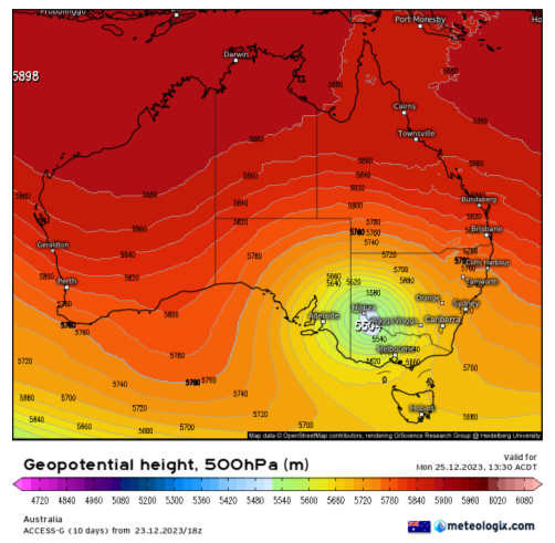
Sunday 24th (Christmas Eve)
Today sees the early stages of the event where the upper trough pinches off from the westerly belt into an upper low. This will rise up through eastern SA behind the ranges up and strengthen where it roots itself over NW VIC. At the same time a broad and deep surface trough that is dominating eastern Australia will deepen in response to this upper low and begin to form a surface low within the trough at the bottom left side and start to bulge to the west later tonight.
Currently at the time of typing this we are seeing some early showers and thunderstorms develop across parts of the Wimmera and SW District in tight clusters ahead of the lift from the upper trough. An isolated thunderstorm has also developed across the Upper SE of SA. Stream showers are moving up from the south across the gulfs and Yorke Peninsula and surrounds in the low-level convergence. The isobars here are beginning to get squeezed and hence the winds are picking up. They will pick up further tonight and into tomorrow.
The showers and thunderstorms across VIC will become scattered to widespread through the afternoon and evening tending to areas of rain more towards the western and southern areas around the base of the developing low-pressure system. The focus for thunderstorms will continue to initiate a little further NW around the leading edge of the upper low with a band developing from late evening which will extend SE.
In SA but late evening, areas of rain will be extending back from VIC around the developing surface low after the shower and isolated thunderstorm activity spreads out to join it.
Monday 25th (Christmas Day)
The entire system begins to mature as the surface low deepens further and wraps right up, extending a wrap around rainband right up the districts east of the ranges in SA, but with a main focus across the eastern half of the Upper SE district and eastern portions of the Mallee and NE part of the Lower SE. The Riverland is also likely to see some but a weaker focus here, especially the southern and SE portions. Areas of steady moderate rain with local heavy falls will develop from what looks like a cold and wet Christmas Day. Fresh to strong southerly winds will accompany the rain, with orographic lift into the SE back side of the Mt.Lofty Ranges enhancing moisture and rainfall into these locations with a drying/lee descent more towards the western portions with more isolated showers although the outer southern suburbs given their hilly terrain may see patchy rain areas mixed with stream showers all day and again accompanied by cool to cold, fresh to strong southerly winds with no real sun at all so quite a miserable day for Christmas in that sense but no doubt many will welcome the rain bar those that haven’t quite finished the harvest yet. Isolated embedded thunderstorms are still likely across the aforementioned regions, especially the Upper SE.
Across VIC the early hours will see the extension of that new band of showers and thunderstorms likely forming a possible squall line or curved band of storms, arcing around the upper low to the SE and S whilst continuing to develop along the band to the north and up into NSW as it moves eastwards. Severe thunderstorms are likely during the afternoon in this portion of the band with all 3 main hazards of damaging wind, flash flooding and large hail. Further south the risk diminishes as the storms tending to rain areas wrapping beneath the low and feeding back west into SA into the wrap around band. A very impressive system. Eventually the shape of the fully mature system will show with a big of a hole appearing where the centre of the low is although showers and thunderstorms are likely to keep adding to the edge of the band. Heavy falls in many areas affected by this system are likely with flooding, some potentially significant with river and stream rises. Please take heed of any river warnings that do come out.
Tuesday 26th (Boxing Day)
The upper low moves NE which will begin to weaken and contract/shrink the heavy rain east of the ranges in SA but still leave residual moisture streams with patchy light rain and/light showers or even drizzle periods with low cloud in a cool and moist and still fresh southerly airstream.
For VIC, showers and isolated thunderstorms will remain but more tempered than Christmas Day. Areas of rain are still likely at times around the bottom side of the low which are likely to cause some interruptions to the cricket. Thunderstorms will likely again be severe in the NE of the state during the afternoon with better access to shear and moisture.
Rainfall
Now over to expected rainfall...
The following is rainfall to approx 9am on the 27th
Kangaroo Island:
General 3-6mm, scattered falls to 10mm in south. Isolated 20mm possible in the south.
Adelaide Plains:
General 4-8mm scattered totals to 10mm in the south isolated 15mm possible in far south.
Mt.Lofty Ranges:
General 10-20mm scattered totals to 25mm, isolated 40mm possible about exposed slopes and windward coasts to the S/SE of over the Fleurieu. Totals decreasing towards northern ranges around 5-10mm.
Riverland:
General 8-15mm scattered totals to 20mm in the far south, isolated 30mm in far south. Totals decreasing towards the western Riverland down to 1-5mm.
Mallee:
General 15-25mm scattered totals to 35mm in the far E/SE. Isolated 40-60mm dumps possible in far SE. Totals lowering towards the NW down to 5-15mm.
Upper SE:
General 35-45mm scattered totals to 55-60mm. Isolated much heavier localised totals in heavier rain areas with embedded thunderstorms of 70-100mm closer to the VIC border. Totals decreasing towards the west down to 15-20mm
Lower SE:
General 15-25mm scattered totals to 30-40mm in the NE isolated 40-60mm dumps possible in far NE and with any thundery activity. Isolated lower pockets still of 8-15mm further west/SW towards the coast.
Western VIC:
General 30-50mm scattered totals to 70mm, isolated 80-120mm dumps possible in thunderstorms and sustained heavy rain areas, chiefly over the Wimmera district, near the Grampians and also in the far east of the SW District. Totals decreasing towards the Mallee of 5-15mm but scattered falls to 30mm in the south with isolated 40-50mm dumps possible towards the Wimmera border and in the far SE of the Mallee. Extreme localised totals of 120-140mm possible over the Grampians and associated areas with training thunderstorms, likely the Wimmera.
Central VIC
General 40-60mm, scattered totals to 80mm, isolated dumps in thunderstorms to 90-120mm. Slight risk of lower totals towards eastern melb suburbs and surrounds if shadowed from the east but still most places should see 25-40mm even in the lower end of the spectrum for the event. Extreme isolated 120-150mm totals from training thunderstorms possible, chiefly towards the ranges N/NW of Melbourne.
Once again, have a very Merry Christmas tomorrow and thank you all for your support as I hope to expand on things a little more in 2024 as I build towards one day making this a full time (and not a part time) gig! Link to temporary blog website: https://farmweathersa.blogspot.com/
Happy Farming and Cheers from The Weatherman
*Note – For interest only, all thoughts are of The Weatherman and may not be reproduced without my consent.


Comments
Post a Comment