Special Update Cut off low Sep 7-9th 2022
Special Update Cut off low Sep 7-9th 2022
Meteorological Discussion
G’Day everyone, as promised a special update on the system due to impact us from the 7th although it is already starting out in the far west of the state with some showers and thunderstorms developing west of the Nullarbor in response to the strong upper trough moving in. I’ll break the discussion down into days so timelines can be clear.
Wednesday 7th:
A broad and deepening low pressure trough will extend eastwards across the state during the day. Aloft a sharpening upper trough will strengthen upper-level divergence and become negatively tilted later in the day – this means the colder air aloft leans forward where the top portion of the trough is leaning further east than the bottom (see attached Figure 1) Severe weather is most common with these types of systems, and I have to say they have always been my favourite for both rain and thunderstorms generally speaking although this one does lack the raw instability that we’d see with a little more warmth so whilst there will be some thunderstorms around, they won’t quite have the same level of grunt as if we had another 10C in temperature.
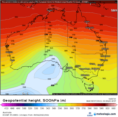
Figure 1: 500hPa (18,500ft) chart showing negatively tilted upper trough for 15:30 local 07/09/22 - source Meteorologix
Some showers and isolated thunderstorms as well as some patchy rain areas will continue to progress SE from the West Coast and Eyre Peninsula during the morning, gradually petering out as it moves further SE at first, however the expectation is that with a combination of solar heating and the approaching triggers in a surface trough and upper trough, renewed showers and thunderstorms will develop across the warm sector over the Eyre Peninsula during the afternoon in a band or couple of bands.
Further north across the Pastorals, further more isolated showers and thunderstorms will develop with a general increase in the coverage and amount of activity as everything moves SE. Now for a majority of the day, there won’t be a great deal anywhere east of the gulf areas so don’t be discouraged or feel like the event has failed if by sunset you have barely had a shower, that will be the general expectation.
The band or bands of showers and thunderstorms will march SE reaching the Yorke Peninsula by roughly 4pm and the Adelaide area approx by 6:30pm though getting precise timing on thunderstorms can be a prickly business. The surface trough will be right up behind this activity and will give good lift as the bands move across the agricultural areas during the evening. The leading edge more so will have the greater risk of thunderstorms, especially across areas north of about Gawler with activity a little messier further south. All of this will gradually spread and amalgamate into a band of rain, perhaps with an embedded rumble or two east of the ranges over the Mallee.
Local heavy falls are possible thunderstorms, especially so where more intense thunderstorm cores are located. Flash flooding is likely in these thunderstorms as well as the potential for damaging wind gusts (the latter increases in probability if we see a bow echo on thunderstorms).
Further north across the NE pastoral, thunderstorms will keep a little cleaner rather than decay into a rainband and thus this increases the severe potential throughout the night and also across the border into Western NSW with the potential for some organised thunderstorms with more grunt allowing for damaging winds and even hail.
The back edge of the rainband will be through Adelaide by approx 1-1:30am and then mostly out of the Mallee and Riverland by sunrise (which is a little quicker than I alluded to in the outlook the other day).
The SE Districts will see a reduced thunderstorm threat and moreso just get a rainband developing very late in the evening on 7th or early 8th and clearing mostly by late morning.
Thursday 8th
Early rain areas over the SE Districts will clear but further west across the West Coast we will see the backside of the low start to blast in with squally showers from before sunrise. As the day progresses, we will see showers develop across the land areas from solar heating, chiefly focused across the Eyre Peninsula, Mid North and some of the Mallee and Ranges areas. Southern Adelaide probably won’t see too much on this day until overnight potentially. There is a chance of an isolated afternoon thunderstorm or two, most likely again over the Eyre Peninsula/Mid North and possibly Riverland and Mallee as the air aloft will still be quite cold. Possible small hail in any stronger cores that develop.
Friday 9th
The blustery conditions out of the SW around the back side of the low will extend eastwards on Friday with more showers wrapping into the agricultural areas, with a focus more into the SE Districts rather than the Eyre Peninsula like the day before. Some showers could be quite squally at times through all activity will gradually die down later as the low moves away.
Rainfall: The following is from the start of the event to about 9am Sat 10th
Eyre Peninsula:
General 12-20mm. Poss totals to 25mm in any thunderstorms, more likely about far NE EP.
Upper North:
General 15-25mm, but some local totals to 40mm in thunderstorm activity.
Lower North:
General 20-30mm, but some local totals to 50mm in thunderstorm activity.
Yorke Peninsula:
General 12-25mm, but some local totals to 30mm in thunderstorm activity, more likely the N.
Kangaroo Island:
General 15-20mm, but some local totals to 25mm.
Adelaide Plains:
General 15-25mm, but some local totals to 30mm near foothills.
Mt.Lofty Ranges:
General 25-40mm, but some local totals to 60mm in known wet spots.
Riverland:
General 12-25mm, but some local totals to 30-35mm in thunderstorm activity or heavier rain areas.
Mallee:
General 12-25mm, but some local totals to 40mm in thunderstorm activity or heavier rain areas.
Upper SE:
General 15-25mm, but some local totals to 40mm in thunderstorm activity or heavier rain areas.
Lower SE:
General 15-25mm, but some local totals to 30-35mm.
Western VIC:
General 20-30mm, but some local totals to 50mm in thunderstorm activity, especially further east closer to the ranges.
Final Notes:
It should be noted that this is a fairly convective event for the most part, so there will be holes, but especially so over the Eyre Peninsula from the activity on Wednesday where the variance could be quite large. The holes will decrease as one heads east however; they will still remain. But overall, if you receive less than 10-12mm from the above districts, you can probably feel hard done by! A good event overall with welcome rain for many and the best since late May potentially however by no means a monster event.
The good news is there is there will likely be a follow up cut off low or complex system mid-month with further good rainfall. Hopefully you all get a nice drop between the two!
Link to temporary blog website: https://farmweathersa.blogspot.com/
Happy Farming and Cheers from The Weatherman
*Note – For interest only, all thoughts are of The Weatherman and may not be reproduced without my consent.


Comments
Post a Comment