September 2022 Outlook SA
September 2022 outlook SA
*Forecast prepared between August 31st-September 5th 2022
Review:
G’Day everyone, and spring has sprung! My favorite season of the year (apart from the hay fever but that’s life). A big Happy Father's Day to you all as well for Sunday. (Apologies for the late issuance of the update, was a busy weekend with work and family gatherings).
No doubt many of you will be pleased with how August turned out, I have to say it went almost exactly to plan which was good to see after a very bad July. I did expect the springback and for the most part we received average to above average rainfall. I’ll post some charts below:
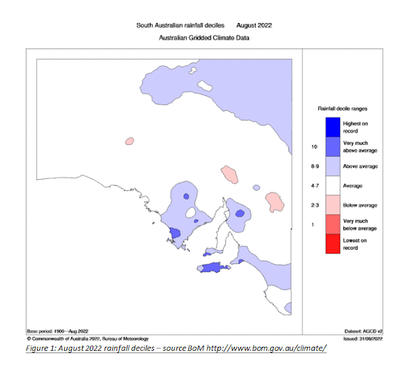


As we can see from the above images, the month was quite good for the agricultural areas with average to above average rainfall – something much needed after July. There were a number of significant frontal systems as well as a couple of cut off lows, some already covered in the mid-month update with the 10th-14th system being the best with a persistent SW-NE penetration however the upper north and Riverland/Mallee areas did quite well with a strong front on Monday 22nd with better inland penetration.
Here is the August outlook for comparisons:
“Overall, August will deliver above average rainfall for most districts with a chance of much above average rainfall over the NE Pastoral, Kangaroo Island, Western Eyre Peninsula and the SE Districts. Most other areas should at least come close to their average. Below average rainfall is
generally not expected over many areas although a risk remains over the western interior north of the Nullarbor and the flats behind the Flinders.“
I’d have to say that’s come off very nicely for the most part, the drier western interior was perhaps a smidge more east, but the monthly average is minimal out there as you can see. The better efforts show more in the higher rainfall areas, and it had the sweet spots over Western Eyre Peninsula, KI, and parts of the SE (with a strange little drier hole). But also, the Upper North really came back nicely and probably exceeded expectations. Drier off the back of the Flinders over the flats was also pretty close to correct with a wetter NE Pastoral, but perhaps that was a little smaller in size with only the NE corner behaving that way but now I am splitting hairs!
Meteorological Discussion:
The month of September is here, a month where the negative IOD really begins to show its hand with more inland rainfall – we aren’t just relying on frontal influence anymore, this is where we get rain (and often good amounts) into areas that normally struggle for the most part. There are no real changes to what we have been talking about from August and generally in the many months prior, this is the time for the bigger systems to start showing up. I mentioned last month I expect a much more significant cut off low to form in September/October, one that really grabs the tropics and gives big totals to many areas over many days with a large memorable impact. It’s hard to pinpoint time frames but the moisture is building very well to the north.
Darwin today (2nd) recorded a nice afternoon thunderstorm with an unofficial 73mm in the rural area. This is very early for build-up thunderstorms to begin and a sign that the tropics are just brimming with moisture. The dewpoints were negative only a few days ago and more prominent troughing is beginning to show on the charts with a focus over the NT moreso than WA/QLD which is even more aggressive than I thought and will favour moisture to flow south with more ease and inland cut off lows to spawn out of these troughs, especially when we are coming out of a strong positive SAM phase (see Climate Drivers section).
Now to begin the month, we’ve got a pretty large high of 1037hpa to move by but due to the SAM being so positive, this high is centred a long way below the mainland and this has some positives. Firstly, with the easterlies around the northern side of the high, it will push moisture west into the mainland from QLD when at the time of the year it is quite common for QLD to have dry westerlies. Secondly, having the centre much further south, dilutes the impact of nasty frosts but it won’t completely remove them so there will still be a cold night and morning on the 3rd.
The main feature is a cut off low that will develop from the west on tues 6th before extending eastwards through wed 7th and thurs 8th. Showers and isolated thunderstorms will develop early over the Far West on 6th before tending to areas of rain through the day. Renewed thunderstorms will develop behind the first band of rain which will act to moisten the low levels and together both bands will progress eastwards and gradually weaken through the evening. Due to a sharpening upper trough which will then become negatively tilted, the surface low will deepen and resulting in more showers and isolated thunderstorms developing early wed 7th out over the Far West and West Coasts. This activity will extend E/SE across the Eyre Peninsula very early in the morning before reaching the Central Districts including Adelaide by around lunchtime or so. Due to the system being stronger than the day before and the negatively tilted upper trough (with a breaking wave type of scenario aloft) more thunderstorms will develop behind the first band of rain on the 7th as well as extend north over the interior. With eastward progression, the system will intensify plus encounter new moisture sourced from the easterlies and NE from QLD/NSW which will thicken activity to a more significant band of rain for areas that have not seen much for a while including the flats off the back of the Flinders and Riverland/Mallee areas. The rear of the rainband should be through the Adelaide longitude by the late evening on 7th. Some good falls are likely from this system overall especially east of the ranges and down over the Lower SE plus into Western VIC. The only downside to this event is there will be some holes due to the fairly convective nature moreso over Eyre Peninsula however I’d suspect most districts will get some handy totals with locally heavy falls in thunderstorms and heavier rain blobs from recently decayed thunderstorms. Overall, thunderstorms over the Pastoral areas and interior will have more grunt and longevity due to greater warmth and instability overall compared to agricultural areas.
As the system moves east the second part begins to move through from the west which is the showery bands circulating around the centre of the low itself. These will mostly move through on Thursday 8th reaching the West Coast early on not far after sunrise and into the Adelaide area by about lunchtime or just after. Showers will be fairly scattered however through the middle of the afternoon, there is a risk of a local thunderstorm briefly across the agricultural areas.
A fresh to strong and at times squally NW-SW flow will establish with this low through later Thursday 8th and Friday 9th with more sunny breaks Friday afternoon as showers become much more isolated.
A weak upper trough will then squeeze the flow aloft on sat 10th bringing isolated showers over the southern agricultural areas but further north across the northern interior near the NT border, the jetstream will be particularly vigorous with another NW Cloudband tapping into the negative IOD moisture generating areas of widespread rain, possibly with some heavy falls which would be most welcome no doubt out there.
After this, things get more complex, but I continue to envisage the expected multitude of cut off lows and complex systems through most of September, one looks likely to form around 14th-15th at this early stage.
A frost window will occur around 12th-14th of September with a moderate strength high moving over the top of the recent colder air aloft that would sink so it could be slight to possibly moderate in nature in the worst spots. Another window but a longer shot lies around 15th-17th but that is more for the mid-month update.
Overall though my outlook for September is for average to above average rainfall. It is the month most likely to exceed the mean though October may be similar. A good chance of well above average rainfall across the NE Pastoral, Mallee, Riverland, Upper North with a tapering to above average over the Adelaide and Mt.Lofty Ranges. The SE Districts should do well too. The greatest chance of below average rainfall is essentially nowhere at all, Western Eyre Peninsula would possibly be the only spot that may just sneak under but that’s a long shot. Looks a very wet month overall. So, no changes from the previous months outlooks with September being a peak month rainfall wise.
Climate Drivers
The Pacific shows no signs of slowing down in the development of another La Nina, it is essentially there in the ocean in a Modoki kind or way (that is cooler more in the middle and warmer west and east) but the Humboldt Current remains persistent and strong which I feel will eventually cool the eastern portions of the Nino 3 region and 1 & 2 to get the La Nina over the line in the BoM’s eyes anyways. Trades are still very stiff into the Australian region; the Coral is a hot soup so really all we see is a consistent signal for a very wet eastern seaboard once again in the coming months.

The Indian has been fairly still, perhaps a slight cooling of the warmer anomalies off the NW coast of Australia and Java, but this is merely the standard oscillations that come in the world of fluid dynamics, nothing moves in a straight line. The latest reading of the IOD was –0.8C which is still below the –0.4C threshold for an official negative event. As mentioned previously I don’t expect 2016 levels, but still a moderate event in the –1.2 to –1.3C range so we have room to move which I expect will come later in September for a peak or at the latest mid-October.
The MJO is currently in phase 2 and fairly strong too which is a partially a reason why we are entering a dry phase at the moment with significant easterlies. This is standard for Australia when the MJO enters phase 2 at such strength. I expect it to push across the mainland during early September but weakening as it does so but still enhance rainfall moreso for tropics to the east and allow easier moisture to begin to feed in.
The SAM is the main driver at the moment with a strong positive phase now underway. This is linked in part as mentioned above to the MJO with the easterlies being strong over the mainland. It is a setting up pattern but for me, I don’t like strong positive SAM phases this early in the year as we do get dry spells from them. As you know, I prefer neutral in spring before more positive in summer. Neutral will allow more regular systems though what the positive event will do is simply set up a greater influx of tropical air ready for when things do move back towards neutral (expected mid-month) to begin to really be ready to link up with fronts and troughs and form significant cut off
lows. I still expect these once we move back towards neutral. Negative SAM events will be unlikely or at the most, very short lived with the broad scale pattern we have atm.
Districts:
Eyre Peninsula
- Northern & Eastern Eyre Peninsula
Fine at first with freshening NE-N winds ahead of a developing cut off low and complex surface troughs extending from the west by early 7th. Scattered showers and isolated thunderstorms tending to areas of rain at times during the day. A secondary band of showers and thunderstorms should develop during the afternoon behind the first after some solar heating although these may be more significant towards the Pastoral areas well to the N & NE. A drier westerly flow establishing behind the trough in the evening. NW to W winds will then freshen early 8th as the surface low passes below the state with gusty showers developing during the day. Isolated afternoon thunderstorms with solar heating, more likely further north before activity dies down in the evening. Weak upper trough 10th with some isolated showers then a final little weak front early 11th with more isolated light showers before a new high moves in with some fine weather once more. Another cut off low or cold front system likely around 14th-15th with rain areas turning to showers. Frost risk 12th-14th being slight. Rainfall for period 12-18mm with isolated totals to 25mm. Slight chance of lower totals to 10mm over more NE EP and the far W of the district.
- Western & Lower Eyre Peninsula
Fine at first with freshening NE-N winds ahead of a developing cut off low and complex surface troughs extending from the west by early 7th. Scattered showers and isolated thunderstorms tending to areas of rain at times during the day. A secondary band of showers and isolated thunderstorms should develop during the afternoon behind the first after some solar heating although these may be more significant towards the N. A drier westerly flow establishing behind the trough in the evening. NW-W winds will then freshen early 8th as the surface low passes below the state with showers developing during the day. Isolated afternoon thunderstorms with solar heating, more likely further north before activity dies down in the evening. Weak upper trough 10th with some isolated showers then a final little weak front early 11th with more isolated light showers before a new high moves in with some fine weather once more. Another cut off low or cold front system likely around 14th-15th with rain areas turning to showers. Frost risk 12th-14th being slight. Rainfall for period 10-15mm with isolated totals to 20mm. Slight chance of lower totals to 7-10mm over more SW Eyre Peninsula but generally should be more.
Upper North
Fine at first with freshening NE-N winds ahead of a developing cut off low and complex surface troughs extending from the west by sunrise on 7th. Scattered showers and isolated thunderstorms tending to areas of rain at times during the day. A secondary band of showers and thunderstorms should develop during the afternoon behind the first after some solar heating although these may be more significant towards the Flinders. This activity will spread to rain areas later. Local heavy falls likely with rapid creek and stream rises in the Flinders. A drier westerly flow establishing behind the trough by the morning of 8th. NW to W winds will then freshen early 8th as the surface low passes below the state with gusty showers developing during the day. Isolated afternoon thunderstorms, chiefly towards the Flinders with all activity then becoming isolated overnight. Renewed streams and showers developing over more exposed and elevated terrain during 9th, chiefly afternoon. Weak upper trough 10th with some isolated showers then a final little weak front early 11th with more isolated light showers before a new high moves in with some fine weather once more. Another cut off low or cold front system likely around 14th-15th with rain areas turning to showers. Frost risk 12th-14th being slight to moderate. Rainfall for period 20-30mm with isolated totals to 50mm, especially with thunderstorms. Slight chance of lower totals to 15mm over the far SW of the district.
Lower North
Fine at first with freshening NE-N winds ahead of a developing cut off low and complex surface troughs extending from the west by sunrise on 7th. Scattered showers and isolated thunderstorms tending to areas of rain at times during the day. A secondary band of showers and thunderstorms should develop during the afternoon behind the first after some solar heating although these may be more significant towards the Upper North. This activity will spread to rain areas later. Local heavy falls likely. A drier westerly flow establishing behind the trough by the morning of 8th. NW to W winds will then freshen early 8th as the surface low passes below the state with gusty showers developing during the day. Possible brief isolated thunderstorm during the afternoon with shower activity becoming isolated overnight and confined to onshore slopes. Renewed streams and showers developing over more exposed and elevated terrain during 9th, chiefly afternoon. Weak upper trough 10th with some isolated showers then a final little weak front early 11th with more isolated light showers before a new high moves in with some fine weather once more. Another cut off low or cold front system likely around 14th-15th with rain areas turning to showers. Frost risk 12th-14th being slight to moderate. Rainfall for period 20-30mm with isolated totals to 45mm, especially with thunderstorms. Slight chance of lower totals to 15mm over the far SW to S of the district and also potentially in the far E.
Yorke Peninsula
- Northern Yorke Peninsula
Fine at first with freshening NE-N winds ahead of a developing cut off low and complex surface troughs extending from the west by sunrise on 7th. Scattered showers and isolated thunderstorms tending to areas of rain at times during the day. A secondary band of showers and thunderstorms should develop during the afternoon behind the first after some solar heating although these may be more significant towards the N end of the district. This activity will spread to rain areas later. Local heavy falls possible. A drier westerly flow establishing behind the trough by the morning of 8th. NW to W winds will then freshen early 8th as the surface low passes below the state with gusty showers developing during the day. Possible brief isolated thunderstorm during the afternoon with shower activity becoming isolated overnight. Renewed streams and showers developing during 9th, chiefly afternoon. Weak upper trough 10th with some isolated showers then a final little weak front early 11th with more isolated light showers before a new high moves in with some fine weather once more. Another cut off low or cold front system likely around 14th-15th with rain areas turning to showers. Frost risk 12th-14th being slight. Rainfall for period 15-25mm with isolated totals to 35mm, especially with thunderstorms. Slight chance of lower totals to 10-12mm over the far S of the district.
- Lower Yorke Peninsula
Fine at first with freshening NE-N winds ahead of a developing cut off low and complex surface troughs extending from the west by early 7th. Scattered showers and isolated thunderstorms tending to areas of rain at times during the day. A secondary band of showers and isolated thunderstorms should develop during the afternoon behind the first after some solar heating over Eyre Peninsula. This activity will spread to rain areas later. Local heavy falls possible. A drier westerly flow establishing behind the trough by the morning of 8th. NW to W winds will then freshen early 8th as the surface low passes below the state with gusty showers developing during the day. Shower activity becoming slightly more isolated overnight although onshore flow will keep showers going about the foot. Weak upper trough 10th with some isolated showers then a final little weak front early 11th with more isolated light showers before a new high moves in with some fine weather once more. Another cut off low or cold front system likely around 14th-15th with rain areas turning to showers. Frost risk 12th-14th being slight further inland to N. Rainfall for period 15-22mm with isolated totals to 30mm, especially with thunderstorms. Slight chance of lower totals to 10-15mm over the foot.
Kangaroo Island
Fine at first with freshening NE-N winds ahead of a developing cut off low and complex surface troughs extending from the west by early 7th. Scattered showers and possible isolated thunderstorms tending to areas of rain at times during the day. A secondary band of showers and isolated thunderstorms should develop during the afternoon behind the first after some solar heating over Eyre Peninsula although these are more likely to tend to patchy rain areas quite quickly. A drier westerly flow establishing behind the trough by the morning of 8th. NW to W winds will then freshen early 8th as the surface low passes below the state with gusty showers developing during the day. Shower activity becoming slightly more isolated overnight although onshore flow will keep showers going about the western end. Weak upper trough 10th with some isolated showers then a final little weak front early 11th with more isolated light showers before a new high moves in with some fine weather once more. Another cut off low or cold front system likely around 14th-15th with rain areas turning to showers. Frost risk 12th-14th being slight further inland towards island centre. Rainfall for period 12-22mm with isolated totals to 25mm, especially with thunderstorms. Slight chance of lower totals to 10-15mm towards far SW/S of island.
Adelaide Plains
Fine at first with freshening NE-N winds ahead of a developing cut off low and complex surface troughs extending from the west by sunrise on 7th. Scattered showers and isolated thunderstorms tending to areas of rain at times during the day. A secondary band of showers and thunderstorms should develop during the afternoon behind the first after some solar heating although these may be more significant towards the N end of the district. This activity will spread to rain areas later. Local heavy falls possible about foothills. A drier westerly flow establishing behind the trough by the morning of 8th. NW to W winds will then freshen early 8th as the surface low passes below the state with gusty showers developing during the day. Possible brief isolated thunderstorm during the afternoon with shower activity becoming isolated overnight. Renewed streams and showers developing during 9th, chiefly afternoon. Weak upper trough 10th with some isolated showers then a final little weak front early 11th with more isolated light showers before a new high moves in with some fine weather once more. Another cut off low or cold front system likely around 14th-15th with rain areas turning to showers. Frost risk 12th-14th being slight about outer plains. Rainfall for period 20-30mm with isolated totals to 40mm, especially with thunderstorms and near foothills. Slight chance of lower totals to 10-12mm over the far S of the district.
Mt.Lofty Ranges
Fine at first with freshening NE-N winds ahead of a developing cut off low and complex surface troughs extending from the west by sunrise on 7th. Scattered showers and isolated thunderstorms tending to areas of rain at times during the day. A secondary band of showers and thunderstorms should develop during the afternoon behind the first after some solar heating although these may be more significant towards the N end of the district. This activity will spread to rain areas later. Local heavy falls likely. A drier westerly flow establishing behind the trough by the morning of 8th. NW to W winds will then freshen early 8th as the surface low passes below the state with gusty showers developing during the day, much more frequent about higher peaks and wet spots. Possible brief isolated thunderstorm during the afternoon with shower activity becoming isolated overnight. Renewed streams and showers developing during 9th, chiefly afternoon. Weak upper trough 10th with some isolated showers then a final little weak front early 11th with more isolated light showers before a new high moves in with some fine weather once more. Another cut off low or cold front system likely around 14th-15th with rain areas turning to showers. Frost risk 12th-14th being slight about low lying valleys. Rainfall for period 30-50mm with isolated totals to 60mm, especially with thunderstorms and near known wet spots and peaks. Slight chance of lower totals to 25-30mm over far southern/SE portions of the Fleurieu Peninsula.
Riverland/Mallee
- Murray Valley
Fine at first with freshening NE-N winds ahead of a developing cut off low and complex surface troughs extending from the west by mid to late morning on 7th. Scattered showers and isolated thunderstorms tending to areas of rain at times during the day. A secondary band of showers and thunderstorms should develop during the afternoon behind the first after some solar heating although these may be more significant towards the N of the district. This activity will spread to rain areas later. Local heavy falls possible though subtle lee shadowing may drop totals a smidge. Rain areas easing by mid-morning on 8th with a drier westerly flow establishing behind the trough by the late morning of 8th. NW to W winds will then freshen early 8th as the surface low passes below the state with gusty isolated showers developing during the afternoon. Renewed streams and light showers developing closer to back of ranges during 9th, chiefly afternoon. Weak upper trough 10th with some isolated showers then a final little weak front early 11th with more isolated light showers before a new high moves in with some fine weather once more. Another cut off low or cold front system likely around 14th-15th with rain areas turning to showers. Frost risk 12th-14th being slight to moderate. Rainfall for period 15-25mm with isolated totals to 30-35mm, especially with thunderstorms. Slight chance of lower totals to 15mm over the far N of the district and in any rain shadows though these won’t be as pronounced as usual.
- Riverland/Northern Mallee
Fine at first with freshening NE-N winds ahead of a developing cut off low and complex surface troughs extending from the west by late morning on 7th. Scattered showers and isolated thunderstorms tending to areas of rain at times during the day. A secondary band of showers and thunderstorms should develop during the afternoon behind the first after some solar heating although these may be more significant towards the N of the district. This activity will spread to rain areas later. Local heavy falls likely during evening and early on 8th with rain areas continuing until mid-afternoon. A drier westerly flow establishing behind the trough by the late afternoon of 8th. NW to W winds will then freshen early 8th as the surface low passes below the state with isolated showers developing during the day in the far west. Possible brief isolated thunderstorm during the afternoon further N/NE with shower activity becoming isolated overnight. Renewed streams and light showers during 9th, chiefly afternoon. Weak upper trough 10th with some isolated showers then a final little weak front early 11th with more isolated light showers before a new high moves in with some fine weather once more. Another cut off low or cold front system likely around 14th-15th with rain areas turning to showers. Frost risk 12th-14th being slight to moderate. Rainfall for period 20-30mm with isolated totals to 45mm, especially with thunderstorms. Slight chance of lower totals to 15-18mm over the far NW of the district.
- Southern Mallee
Fine at first with freshening NE-N winds ahead of a developing cut off low and complex surface troughs extending from the west by late morning on 7th. Scattered showers and isolated thunderstorms tending to areas of rain at times during the day. A secondary band of showers and thunderstorms should develop during the afternoon behind the first after some solar heating although these may be more significant towards the N of the district. This activity will spread to rain areas later. Local heavy falls likely during the evening and early on 8th with rain areas continuing until early afternoon in the east. A drier westerly flow establishing behind the trough by the afternoon of 8th. NW to W winds will then freshen early 8th as the surface low passes below the state with isolated showers developing during the day, chiefly in the west. Possible brief isolated thunderstorm during the afternoon further N/NE with shower activity becoming isolated overnight. Renewed streams and light showers during 9th, chiefly afternoon. Weak upper trough 10th with some isolated showers then a final little weak front early 11th with more isolated light showers before a new high moves in with some fine weather once more. Another cut off low or cold front system likely around 14th-15th with rain areas turning to showers. Frost risk 12th-14th being slight to moderate. Rainfall for period 20-30mm with isolated totals to 40mm, especially with thunderstorms. Slight chance of lower totals to 12-15mm over the far NW/W of the district.
Upper SE
Fine at first with freshening NE-N winds ahead of a developing cut off low and complex surface troughs extending from the west by late morning on 7th. Scattered showers and isolated thunderstorms tending to areas of rain at times during the day. A secondary band of showers and thunderstorms should develop during the afternoon behind the first after some solar heating although these may be more significant towards the N of the district. This activity will spread to rain areas later. Local heavy falls likely during the evening and early on 8th with rain areas continuing until early afternoon in the east. A drier westerly flow establishing behind the trough by the evening of 8th. NW to W winds will then freshen later on 8th as low passes below state. Renewed streams and light showers during 9th, chiefly afternoon. Weak upper trough 10th with some isolated showers then a final little weak front early 11th with more isolated light showers before a new high moves in with some fine weather once more. Another cut off low or cold front system likely around 14th-15th with rain areas turning to showers. Frost risk 12th-14th being slight to moderate. Rainfall for period 20-30mm with isolated totals to 30-35mm, especially with thunderstorms. Slight chance of lower totals to 12-15mm over the far NW/W of the district.
Lower SE/ SW VIC
Fine at first with freshening NE-N winds ahead of a developing cut off low and complex surface troughs extending from the west by later on 7th. Scattered showers and isolated thunderstorms extending from the north, tending to areas of rain later in the evening. Area of rain continuing on 8th before contracting SE later in the day. Local heavy falls likely. A drier westerly flow establishing behind the trough by the morning of 9th although likely short-lived. W to SW winds will then freshen on 9th as low passes below state. Showers increasing during the day around back side of the low before easing during the evening. Weak upper trough 10th with some isolated showers then a final little weak front early 11th with more isolated light showers before a new high moves in with some fine weather once more. Another cut off low or cold front system likely around 14th-15th with rain areas turning to showers. Frost risk 12th-14th being slight to moderate. Rainfall for period 25-40mm with isolated totals to 50mm. Slight chance of lower totals to 20-25mm over the far SW/W of the LSE District.
Wimmera
Fine at first with freshening NE-N winds ahead of a developing cut off low and complex surface troughs extending from the west by later on 7th. Scattered showers and isolated thunderstorms extending from the north, tending to areas of rain later in the afternoon or early evening. Area of rain continuing 8th before contracting SE later in the day. Isolated embedded thunderstorms possible, chiefly afternoon and in the north. Local heavy falls likely. A drier westerly flow establishing behind the trough by the morning of 9th although likely short-lived. W to SW winds will then freshen
on 9th as low passes below state. Showers increasing during the day around back side of the low before easing during the evening with a possible afternoon thunderstorm also. Weak upper trough on 10th with some isolated showers then a final little weak front early 11th with more isolated light showers before a new high moves in with some fine weather once more. Another cut off low or cold front system likely around 14th-15th with rain areas turning to showers. Frost risk 12th-14th being slight to moderate. Rainfall for period 30-40mm with isolated totals to 50mm. Slight chance of lower totals to 25-30mm over the far SW/W.
VIC Mallee
Fine at first with freshening NE-N winds ahead of a developing cut off low and complex surface troughs extending from the west by later on 7th. Scattered showers and isolated thunderstorms extending from the north, tending to areas of rain later in the late afternoon. Area of rain and isolated embedded thunderstorms continuing 8th before contracting SE later in the day. Local heavy falls likely. A drier westerly flow establishing behind the trough by the morning of 9th although likely short-lived. W to SW winds will then freshen on 9th as low passes below state. Isolated to scattered showers increasing during the day around back side of the low before easing during the evening with a possible afternoon thunderstorm in the south. Weak upper trough on 10th with some isolated showers then a final little weak front early 11th with more isolated light showers before a new high moves in with some fine weather once more. Another cut off low or cold front system likely around 14th-15th with rain areas turning to showers. Frost risk 12th-14th being slight to moderate. Rainfall for period 20-30mm with isolated totals to 40mm. Slight chance of lower totals to 15-20mm over the far E but generally some very welcome falls.
Finals Notes:
- Negatively tilted trough, my favourite type which will favour good rain and thunderstorms across many districts from 7th. Local heavy falls likely. Special update will come out right before event to nail final intricacies and totals.
- Negative IOD now ramping up as expected with multiple cut off events
- More thundery events through spring with extra moisture feed from QLD and NSW being the main booster
- October and November looking wet, but especially October at this stage. Severe thunderstorms will occur with the extra moisture
- December may trend a little drier but a lot of this depends on how wet we get in October and November as a feedback from very moist soil will occur, but I expect a fairly standard December at this stage.
- Early outlook for remainder of summer into 2023 is becoming much drier with more heat through February. Humidity though likely to be up, especially east of the ranges at times.
Link to temporary blog website: https://farmweathersa.blogspot.com/
Happy Farming and Cheers from The Weatherman
*Note – For interest only, all thoughts are of The Weatherman and may not be reproduced without my consent.


Comments
Post a Comment