May 2022 Outlook SA
May 2022 outlook SA
*Forecast prepared between Apr 27th-28th 2022
Review:
G’Day one and all, this outlook comes a little earlier than usual but as I’ll be away from the 30th and not back till late on the 6th, I thought I’d push it out early. Yes, that might affect a few little tidbits but overall shouldn’t make too much difference. We are starting to change and will explain more through the sections below.
Recently, as per the special update we’ve managed some very solid inland rainfall, with lighter falls extending to some agricultural areas, chiefly the western and northern however some low-level moisture combined with orographic lift and drizzly continuous rain periods gave some locally higher totals on the back side of the ranges with 30mm at Keyneton in the NE flow which is extremely rare to see but no doubt welcome. Otherwise, the rainfall was close to expectations apart from the Lower and Upper North which were light on. Some 10-15mm falls in the Riverland which would have been handy but drying out a lot further south with next to nothing towards Adelaide.
Looking back at the month so far it has been a mixed bag, very dry for the first half then patchy rainfall for the second with some locally heavy totals over Pastoral areas and also the West Coast. A system on the 29th will deliver further rainfall so whilst the forecast looks reasonable for the southern coastal areas, further north and west it has exceeded expectations with mostly average rainfall and some above average. A bit out of each pot so to speak but I will bring the final review and charts for the Mid May update once the month has a chance to complete.
Meteorological Discussion:
Currently as of early Thursday 28th we have a freshening NE/N airstream ahead of an approaching weak surface trough. This is being closely followed by a weak cold front as well attached to a fairly stout Southern Ocean low. All of this is embedded in a broadscale longwave node showing prominently in the upper levels but alas it is weakening and sliding SE. Further north across the NT/QLD border we have a strengthening upper-level high directing a NW flow aloft along the jetstream across the state. As the high strengthens and the longwave moves east we will see a squeezing of the mid and upper level jetstream which will accelerate the flow and increase upper divergence. As a result a new cloudband will streak out of the moisture feeding in off the Indian Ocean and rapidly develop through early to mid-Friday 29th with dynamic uplift. Scattered mid-level showers and isolated thunderstorms will form along this swift flow and increase and amalgamate to areas of rain as it moves eastwards. Initially though a lot of the activity is going to be convective and sporadic with rapid fire and fast-moving mid-level showers with isolated thunderstorms thrown in. Most of this will stream down NE of a line roughly Tarcoola to Whyalla to Gawler to Lameroo and then thicken. It is a shame most of this will happen further east but that is what we get. SW of this it will mostly be light shower activity before the top portion of the colder air pool below KI rapidly moves through, mostly impacting the Lower SE in the early hours of sat 30th. All this activity should then rapidly clear as a new high ridges in from the west.
This mid-level cloudband will thicken further into NSW as it taps into a secondary moisture feed off the Gulf of Carpentaria and deliver better rainfall once again to inland areas of NSW.
Stable conditions are likely to start May off with that new high but another weak front will move up swiftly from the SW to cross the state on Tues 3rd with a broken band of showers, more isolated inland and further west. Scattered stream showers will follow, more frequent and widespread about the Lower SE into Wed 4th. A further weak trough will shoot up from the south ahead of a strong high-pressure system on thurs 5th with more isolated shower activity and low-level moisture onto southern coast and ranges especially. After this the large high will steadily move eastwards although isolated coastal shower activity is still likely under a stout inversion with some weak upper cold pool action to move in aloft above the high to give them a little kick, though not a lot in it.
Beyond this, I still expect that period of ridging to continue before the fronts start to make a move from mid to late May and certainly into June. Cut off lows are likely through winter as well as good fronts given the ample warm moist feeds ahead of fronts and the warm seas right around the country. Overall, my early outlook for May is average to below average rainfall for the most part, however, some near average to barely above average conditions may present themselves across the NE Pastoral from inland feeds and also portions of the Far West Coast, KI and Lower SE, especially later in the month.
Climate Drivers
The mighty Pacific Ocean refuses to lay down its gloves, if anything a colder slither of water has upwelled in the last week and a half, refer to Figure 1:
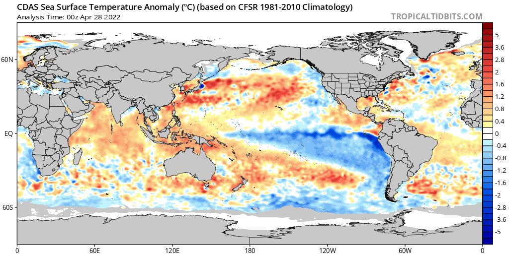
Figure 1: Current SST anomalies showing La Nina still hanging on – source Tropical Tidbits https://www.tropicaltidbits.com/analysis/ocean/
The colder sub-surface water that I alluded to in the mid-April update has now risen the the surface and can clearly be seen as the colder narrow slither off the NW coast of Peru and extending west. This shouldn’t last too long as this colder water is not being replaced from below. Warmer anomalies at depth continue to build in the western Pacific and this is no surprise given how warm all the water is right around the Indo-Australian region. Trade winds have been still impressively strong over the Western Pacific and have helped in driving large amounts of rainfall into the Tropical QLD coastal districts and then later on, further inland with some other help from the west. I expect this La Nina to continue to very slowly weaken off to a cool neutral level, but I’d say that’s the furthest it will go before we do indeed have a crack at a triple dip, something I hinted at a while ago but the odds of such an event actually occurring are very small. It’s as close to it as anything given the pattern and with a likely negative IOD, there will not be the strong westerly bursts rocketing in from the Indonesia region into the Pacific to swing it to the warmer side of neutral. A very impressive event and one that will only act to keep moisture piling into Eastern Australia.
Now the Indian is just a hot soup atm, from west to east and almost from north to south as well. This has been a very consistent pattern for a few months now with no strong high pressure to send strong trades up across the Indian, all the action is from the Pacific with much lighter winds across the Indian with some westerly anomalies present – often the leading precursor to the first stages of negative IOD event from about May onwards. I do expect a subtle and steady removal of those
warmer anomalies across the basin, but the warmth shouldn’t remove from the east, and this is how we will trend towards a negative IOD through winter and early spring 2022. I’ve expected an above average winter for the most part but typical negative IOD’s of substance (lower than –1C) show a peak through July to September with generally above average to well above average rainfall with numerous significant cut off lows. I’ve thought we’d get from a weak to moderate event, but if this warmth continues to hold through May, then that could well become a moderate to strong event and last well into Spring. Good inland rainfall has already occurred to our north and NE which increases soil root zone moisture content, reducing the drying out effect of strong NE/N winds ahead of westerly fronts giving rise to rainbands that do not fall apart as frequently as normal. By Spring 2016 for example (the strongest we have seen in modern times with a –1.5C value), soils were saturated over a lot of inland QLD and NSW and outback SA as well. It is then no surprise powerful cut off lows with flooding and damage then occurred through September 2016. Now I am not saying we will see a repeat of that however, the trend needs to be noted and monitored closely in the next month or two.
The MJO is of a weak to moderate strength back in the Indian Ocean atm but will taper off as it moves closer to the Australian mainland by early to mid-May. This will however kick some westerly anomalies further into the Sumatran Peninsula and act to kickstart the negative IOD so this needs to be monitored. It should also act to at least provide a pool of convective activity for fronts to tap into for the second half of May.
Now the important index as we move into winter will be the SAM. Traditionally, a strong negative SAM helps bring the fronts up high and deliver good rainfall with southern maritime air. In negative IOD’s and La Nina’s however the balance needs to be more centred in the middle where fronts meet the tropical feed. Typically, with any form of La Nina to cool neutral entrenched, we have a bias to the highs sitting a little further south which in turn causes the SAM index to become a little more positive. This allows a more ready supply of the tropical moisture to come south and be available to meet any front that stands up and squeezes the jet. So, a balance to more neutral levels is the most beneficial as we get a bit from basket A and basket B. Of course, we’d all like a perfect world and the atmosphere/ocean is far from that!
Currently the index is neutral and should tend a little negative towards the end of April and early May as the Southern Ocean stirs some solid lows however this will be short lived with more strong ridging and high pressure expected behind these lows causing the index to once again push back towards positive territory although not by much which is ok for that balance talked about in the paragraph above.
Districts:
Eyre Peninsula
Weak trough and front to combine early 29th with isolated mid-level showers, potentially with isolated thunderstorms in the far NE/N. New ridge replacing front with mostly fine conditions ahead of a freshening N to NW flow ahead of a weak front moving in from the SW on 3rd with a broken band of showers, more isolated and lighter inland. Isolated stream showers to follow in onshore maritime flow but not a lot in it. Secondary weak trough on 5th possible with further light shower activity, chiefly coastal in cool southerly flow. Strong high moving in behind continuing light coastal shower activity at times before contracting SE and clearing towards the weekend on 7th/8th. Rainfall for the period generally light in the order of 2-3mm, but potentially some falls to 5-8mm in the far N/NE.
Upper North
Weak trough and front to combine early 29th with isolated mid-level showers at first, becoming scattered through the afternoon and evening with isolated thunderstorms before combining into broken band of rain towards the east and north of the district – less likely in the south. New ridge replacing front with mostly fine conditions ahead of a freshening N to NW flow ahead of a weak front moving in from the SW later on 3rd with a broken band of isolated showers. Isolated stream showers to follow in onshore maritime flow but not a lot in it and chiefly about higher slopes/terrain south of about Melrose. Secondary weak trough on 5th possible with further light shower activity. Strong high moving in behind continuing isolated light shower activity at times before contracting SE and clearing towards the weekend on 7th/8th. Rainfall for the period around 3-8mm, increasing to 10-15mm in the north and east but decreasing to 2-3mm in the south.
Lower North
Weak trough and front to combine early 29th with isolated mid-level showers at first, becoming scattered through the afternoon and early evening with an isolated thunderstorm or two. New ridge replacing front with mostly fine conditions ahead of a freshening N to NW flow ahead of a weak front moving in from the SW later on 3rd with a broken band of showers. Isolated stream showers to follow in onshore maritime flow but not a lot in it and chiefly about higher slopes/terrain. Secondary weak trough on 5th possible with further light shower activity. Strong high moving in behind continuing isolated light shower activity at times before contracting SE and clearing towards the weekend on 7th/8th. Rainfall for the period generally around 2-3mm with possible isolated 4-6mm totals about higher terrain and also in the far E/NE of the district.
Yorke Peninsula
Weak trough and front to combine early 29th with isolated mid-level showers, briefly becoming scattered during the afternoon Possible isolated thunderstorm about the far N of the Peninsula. New ridge replacing front with mostly fine conditions ahead of a freshening N to NW flow ahead of a
weak front moving in from the SW on 3rd with a broken band of showers. Isolated stream showers to follow in onshore maritime flow but not a lot in it and more likely about the foot. Secondary weak trough on 5th possible with further light shower activity in a cool southerly flow. Strong high moving in behind continuing isolated light shower activity at times before contracting SE and clearing towards the weekend on 7th/8th. Rainfall for the period generally around 2-4mm with possible isolated totals to 5-6mm about the foot.
Kangaroo Island
Weak trough and front to combine early 29th with isolated mid-level showers, briefly becoming scattered during the afternoon. Cold pool clipping island with some locally heavier showers potentially during the evening. New ridge replacing front with mostly fine conditions ahead of a freshening N to NW flow ahead of a weak front moving in from the SW on 3rd with a broken band of showers. Isolated stream showers to follow in onshore maritime flow but not a lot in it. Secondary weak trough on 5th possible with further scattered shower activity in a cool southerly flow. Strong high moving in behind continuing isolated light shower activity at times before contracting SE and clearing towards the weekend on 7th/8th. Rainfall for the period generally around 3-6mm with possible isolated totals to 6-8mm.
Adelaide Plains
Weak trough and front to combine early 29th with isolated mid-level showers, briefly becoming scattered during the afternoon and early evening. New ridge replacing front with mostly fine conditions ahead of a freshening N to NW flow ahead of a weak front moving in from the SW on 3rd with a broken band of showers. Isolated stream showers to follow in onshore maritime flow but not a lot in it, more likely about the foothills and southern suburbs. Secondary weak trough on 5th possible with further light shower activity in a cool southerly flow, chiefly in the south. Strong high moving in behind continuing isolated light shower activity at times before contracting SE and clearing towards the weekend on 7th/8th. Rainfall for the period generally around 2-4mm with possible isolated totals to 5-6mm about foothills.
Mt.Lofty Ranges
Weak trough and front to combine early 29th with isolated mid-level showers, briefly becoming scattered during the afternoon and early evening. New ridge replacing front with mostly fine conditions ahead of a freshening N to NW flow ahead of a weak front moving in from the SW on 3rd with a broken band of showers, more frequent about southern coasts and ranges. Isolated to scattered stream showers to follow in onshore maritime flow, potentially tending to drizzle periods at times in the south and higher peaks. Secondary weak trough on 5th possible with further light shower activity in a cool southerly flow, chiefly in the south. Strong high moving in behind continuing isolated light shower activity at times before contracting SE and clearing towards the weekend on
7th/8th. Rainfall for the period generally around 4-8mm with possible isolated totals to 10-15mm about higher peaks and exposed southern coasts and ranges.
Riverland/Mallee
Weak trough and front to combine early 29th with isolated mid-level showers at first, becoming scattered through the afternoon and evening with isolated thunderstorms about the Riverland before combining into broken band of rain towards the east and north of the district however generally only isolated mid-level showers for the Mallee with perhaps a brief thunderstorm in the north towards the Riverland and border areas. New ridge replacing front with mostly fine conditions ahead of a freshening N to NW flow ahead of a weak front moving in from the SW later on 3rd with a broken band of isolated showers, though much weaker over the Riverland. Isolated stream showers to follow in onshore maritime flow but not a lot in it and chiefly about the SW Mallee only. Secondary weak trough on 5th possible with further light shower activity, more likely closer to the back of the Mt.Lofty Ranges. Strong high moving in behind continuing isolated light shower activity at times in the southern Mallee before contracting SE and clearing towards the weekend on 7th/8th. Rainfall for the period around 4-8mm in the Riverland with isolated totals to 10-12mm in the far N. Totals decreasing through Mallee with 2-4mm generally speaking.
Upper SE
Weak trough and front to combine during 29th with isolated mid-level showers at first, becoming scattered through the afternoon and evening, especially in the south as a pool of cold air moves by. New ridge replacing front with mostly fine conditions ahead of a freshening N to NW flow ahead of a weak front moving in from the SW on 3rd with a broken band of showers. Isolated stream showers to follow in onshore maritime flow but not a lot in it. Secondary weak trough on 5th possible with further light shower activity. Strong high moving in behind continuing isolated light shower activity at times before contracting SE and clearing towards the weekend on 7th/8th. Rainfall for the period around 2-5mm with possible 5-8mm totals in the far south.
Lower SE
Weak trough and front to combine during 29th with isolated mid-level showers at first, becoming scattered through the afternoon and evening. Showers becoming more frequent late evening and into early 30th with pool of cold air with possible isolated thunderstorms and small hail as well as locally heavier showers. New ridge rapidly replacing front however on 30th although the prominent westerly onshore flow will drive scattered showers across the district from time to time. Freshening N to NW flow ahead of a weak front moving in from the SW on 3rd with a broken band of showers, heavier in the south. Scattered stream showers to follow in onshore maritime flow with another cold pool to rapidly move through on 4th with colder conditions. Possible small hail once again. Secondary weak trough on 5th with further shower activity with a third trough or front moving below the mainland throwing up showers once again. Strong high moving in behind continuing isolated light
shower activity at times before contracting SE and clearing towards the weekend on 7th/8th. Rainfall for the period around 5-8mm though isolated to scattered totals of 15-20mm are likely the further south one goes. Totals less than 5mm in the far north and east.
Finals Notes:
· Modest and patchy rainfall to see out April and begin May – no proper break yet
· Period of high pressure expected through early to Mid-May still on track
· Improvement in system potential in the second half of May, and more so into June
· Negative IOD well on its way and this time, the impacts should be more noticeable than the last 2years.
Link to temporary blog website: https://farmweathersa.blogspot.com/
Happy Farming and Cheers from The Weatherman
*Note – For interest only, all thoughts are of The Weatherman and may not be reproduced without my consent.


Comments
Post a Comment