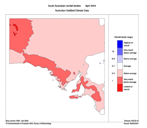
Special Update SA Upper trough with rain/showers April 24-27th
Special Update SA Upper trough with rain/showers April 24-27th
Meteorological Discussion:
G’Day everybody, it’s come to that time now where a special update is required as that end of month system has developed accordingly although it is not without it’s limitations.
At present it is Sunday 24th morning and we have a weak surface trough angled down across the centre of the state from the NE generating some isolated mid-level showers – Altocumulus Castellanus and a sure sign of de-stabilising mid-levels. Shower activity is more scattered to widespread across the NE Pastoral and Flinders where moisture depth is greater along with increasing isolated thunderstorms. This activity with the NE steering present, thanks to the deep and strong high further to the S/SE offshore, will continue down towards the Eyre Peninsula and West Coast districts throughout the afternoon and evening and gradually expand and thicken into areas of rain tonight, especially over the West Coast where I would expect some locally moderate to heavy falls and this is because it will be where the surface trough slows down before pivoting around and moving back eastwards due to the upper low becoming re-attached to the broadscale upper long wave and giving it a kick.
Now the issue I have is further east across areas south of the Upper North and especially so for the Mallee, Adelaide, Mt.Lofty Ranges, KI and SE districts. In these districts, the strong high-pressure that is actually mostly responsible for driving his moisture down into SA in the first place will act to shunt and hold the surface trough and convergence too far north and west. If you check my mid-April update, this was my main concern with this system, and little has changed.
However, there will be a window where these districts do get some rainfall, especially ones of about Adelaide and north of if you draw a line across west to east. It will be extremely hard work for areas south of this rough line to get anything meaningful out of the event and with increased distance south, this becomes harder and harder with the source of uplift being further away.
In any case on the 25th we will see a lot of the focus initially be from the NE Pastoral and down to the West Coast with most other districts being generally clear so for those of you attending the important dawn services around the state it shouldn’t be too bad nor too cold for most areas east of about Western Eyre Peninsula. As the day wears on we will see the pivot of the system occur and rain areas will extend southwards from the NE Pastoral down through the Upper and Lower North, Yorke Pen and Riverland gradually reaching the Mallee probably by the early parts of the 26th and persist through most of the day, more general the further north one goes.
Over the border though in NSW, rainfall will be more significant (now who is surprised here), especially about 100km+ into western NSW which will see some tremendous rainfall with long-lived and slowed down convergence of that tropical moisture, 30-50mm is quite likely with isolated totals in excess of 60mm.
This system is more of that classic rogue event rather than a seasonal pattern break but giving good rainfall for some districts will potentially set them up for a break, especially the western and northern portions of the Eyre Peninsula which would have some good sub-soil moisture. But we still need a good cold front and long wave trough to stand up and capture that moisture, there are hints we will see these come from the Perth longitude but the peak of the wave to me at this stage looks that bit too far west, however I will watch closely as any decent front will no doubt trigger a solid rain event.
Rainfall:
Eyre Peninsula: - 15-20mm generally, decreasing down to 7-15mm further south and east. Higher totals to 30-40mm over the far northern and western portions of the Peninsula and West Coast.
Upper North: 7-15mm increasing to 15-25mm north of about Quorn with much higher totals further up the Flinders nearing 50mm potentially in the north of the district.
Lower North: - 5-10mm with isolated 10-15mm in the north and east.
Yorke Peninsula: - 3-5mm increasing to 7-15mm in the north
Kangaroo Island: - Less than 3mm
Adelaide Plains: - 3-6mm, isolated 8-10mm possible in far north
Mt.Lofty Ranges: - 5-8mm, isol 10-12mm in north
Riverland: - 8-15mm but isolated 20-25mm potentially in the far northern portions
Mallee: - 3-8mm generally, closer to 8-10mm in the north and NE portions potentially
Upper and Lower SE: - Less than 3mm generally to nothing at all over the Lower SE. I should also add that portions of the NE Pastoral should see 20-40mm but isolated totals especially with thunderstorms in the order of 60-80mm are not beyond a chance. So in short, handy rainfall for some and even potentially a patchy break but not what I would call a proper break just yet but at least we have moisture, we are one step closer now.
Will keep eyes on fronts after this event but am still expecting that period of high pressure after into early May as per the last update. Happy Farming and Cheers from The Weatherman


Comments
Post a Comment