April 2022 Outlook SA
April 2022 outlook SA
*Forecast prepared between Mar 31st-Apr 4th 2022
Review:
G’Day everyone, another month down, actually hard to believe we are now well into autumn
and before we know it winter will be here.
A month of being stuck in between two main infeeds east
and west with heavy falls and major flooding as expected sadly in NSW and also parts of QLD. Finally, WA saw some heavy
falls for the first time all summer, but SA was dominated by constant ridging
which was continuously re-enforced from the Bight creating stable conditions
for the most part through especially Central areas. We did see the eastern
border areas in the earlier part of the month come under the influence of a
surface trough which generated diurnal shower and thunderstorm activity with
some locally heavy falls, especially over parts of the Upper SE and also the Flinders and NE Pastoral.
Looking back at the March outlook I think overall it
performed well for the expected pattern but underestimated the dry area a bit
as it extended down a smidge more east across some parts of the Western Upper
North also. See Figure 1. The anomalies as usual show it to finer detail in
Figure 2 with a wider swath of slightly below average being the mainstay. The
eastern border areas came up quite close to expectations. The below text was
the outlook for March to recap.
“Overall, my outlook for March will see very close
to average rainfall, slightly above in the far west and parts of the SE
districts with a risk of at least average to above average rainfall this time
into the NE pastoral up the border though patchy. Most other areas look about
average. The main below average risk is probably over areas such as the
southern NW pastoral and down through Yorke Pen and perhaps KI as well which
would roughly be a zone between moisture enroaching from the west and influence
from the east.”
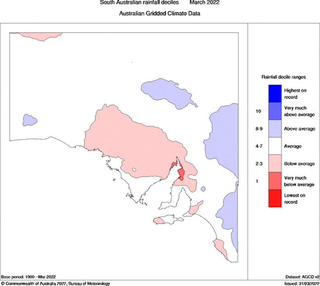
Figure
1: Rainfall deciles for SA for March 2022 – source BoM http://www.bom.gov.au/climate/

Figure
2: Rainfall anomalies for SA for March 2022 – source BoM
http://www.bom.gov.au/climate/
Meteorological Discussion:
April is now here and no doubt a very critical month for
many of you wanting to get seeding done and looking for that break. We have a fairly contrasting cropping region with the Eyre and
Yorke Peninsula’s likely to have good sub soil moisture but the Mallee and some
areas of the Lower and Upper North being a lot less but especially anywhere
east of the Ranges and down into the Upper SE. Of course, thunderstorm activity
has given a few localised spots some buffer, but it does not make up the
majority.
At this stage I see nothing significant on the horizon in
what looks like a fairly dry month dominated by
surface ridging. The curveball is this often throws up more upper troughing
aloft however this will focus further east and activate rainfall over the Eastern
states where the Tasman/Pacific moisture can be utilised better, especially in
the form of those East Coast Lows (ECL’s).
Active sunspot activity throwing out significant CME’s
will be a feature of April as well – we have already seen an X class flare in
the last few days. This does cause turbulence in the earth’s jetstream so I am
still open to a rogue system at some point during the month but overall, the
trend is dry with that Indian summer like pattern showing up on multiple
occasions.
Anyways moving onto current events and we have the
leftovers of the strong East Coast low that brought heavy rainfall to many
parts of NSW and VIC over the last few days. This low is now weakening and
heading east into the Tasman. Further west middle and upper-level cloud on the
satellite imagery is associated with an upper trough and this will advance
eastwards in the next day or two. A weak inland trough will develop in
association with this upper trough and together they will combine for some
patchy rain and mid-level showers over the state on the 5th but totals will
remain low due to a lack of connectivity to the tropics and strength in the
overall system.
After this we see the re-strengthening of the
high-pressure system near Tasmania which will extend a strong ridge over the
state in a E/NE flow. Without surprising anyone, the upper trough from the 5th
will then stall over the eastern states and combine with a surface trough to
generate showers and thunderstorms with locally heavy falls and flash flooding,
with a little more inland focus this time round.
Further ridging will follow over SA, but a slight
stirring of the westerly belt is expected around the 10th-11th
behind the first strong high which may see a troughy system again bring
mid-level showers and patchy rain areas with isolated thunderstorms in the
west. A cooler kick out of the SW could follow with another strong high behind
and this pattern will push right through past mid-month at this stage with a
likely repeat right through a bulk of April. As mentioned, the only ‘positive’
from so much high pressure with upper troughing is the blocking that occurs and
eventually a rogue cut-off may occur a bit further west than they have been
occurring for the last month or two. One to watch but for now we unfortunately have to wait.
Consequently, my outlook for April is below average
rainfall for a large swath of the state. Pockets to scattered areas of well
below average are likely, especially over the Pastoral Districts once again but
even down through the southern coastal districts and into the SE. The best
chance of average rainfall at least is over parts of Eyre Peninsula and into
the Upper North.
Climate Drivers
The Pacific is ever so slowly showing signs of breaking
down the La Nina pattern in the oceans but the lag effect to the atmosphere
will remain and as a result the moisture pile in from the east into the eastern
seaboard will continue. The signs are the warming in the very far Eastern
Pacific especially. Strong ridging over the SA/VIC/TAS region will essentially
allow upper troughing aloft due to the block and this will in turn act to cause
cyclogenesis on the east coast giving all these East Coast Lows (ECL’s) we are
seeing atm. Multiple nasty little lows, with flooding, damaging wind and
coastal erosion caused by large and powerful waves. This happened in 1974 with
the strong La Nina, the pattern has been very classic for the east, but we are
battling in the middle with the ‘overstrong’ high pressure and sinking air.

Figure
3: Current SST anomalies – source Tropical Tidbits https://www.tropicaltidbits.com/analysis/ocean/
No big
changes in the Indian, it remains warm and a fairly
active basin weather wise with plenty of convection and certainly a lot of
warm water off the NW coast of WA and in the Eastern Indian in general. It
bodes well for when we get a break rain but for now, the overruling pattern of
dryness will remain as the downwelling/sinking air of the Hadley cell holds
strong but having the Indian this warm is always better than having it cold.
Refer to Figure 4 which shows the sinking air in red approaching from the west
in the wake of the recent MJO pulse.
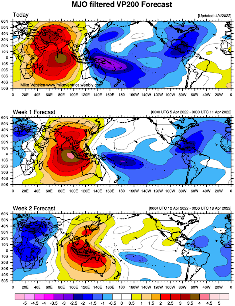
Figure
4: CHI200 index showing rising air in blues and purples and sinking air in reds
and browns – source http://mikeventrice.weebly.com/mjo.html
In terms of what the IOD might do for this year, I’m seeing quite a bit of talk
about a hefty negative event but I remain very
cautious. Whilst there is a lof of warm water currently I do expect that to
decrease as winter and spring come around. A similar level to last year is looking the leading bet at this stage whilst we have the
warmth, the strength of warm east and cold west mechanism is still looking
tardy so a weak negative IOD may hang around. They are not the best for
consistent rainfall over Southern Australia, patchy and inconsistent more the
order of the day. But this time of the year is usually very tricky to nail
accurate IOD forecasts as we still have significant convection churning out
over the Indian. I will review this each update given how critical this index
is to SA.
The MJO
has weakened off once it moved over the maritime continent through phases 4-5
and is now lingering very weakly in phase 6 to 7 and becoming very hard to make
out. This is likely to continue now for a number of
weeks with perhaps a bias to the Pacific Ocean flaring up a couple of Tropical
Cyclones, the first which is already organising west of Vanuatu. This will
rapidly intensify before getting sucked into the giant upper troughing that
continues to induce the east coast lows and enter the Coral Sea graveyard but
not before becoming quite intense – category 3 to 4 is most likely. Large swell
the most likely impact on the Australian coastline.
The SAM
is currently positive after the recent large high pressure that has been
dominating the mainland and Southern Ocean giving us ridging with a SE/E flow.
This will continue to be mostly positive for a week before a tick down into
neutral regions as the belt of high-pressure eases off a little and we see some
frontal action over the Southern Ocean/southern coastline.
Districts:
Eyre Peninsula
Upper trough on 5th delivering patchy rain
areas before a new ridge moves in behind from the 6th. Mostly fine
conditions becoming established throughout till 10th ahead of an
approaching trough around the 11th which may bring areas of patchy
rain once again. Isolated thunderstorms in the west. More southerly flow likely
behind trough bringing onshore isolated shower activity to exposed coasts with
cooler conditions ahead of further ridging by mid-month stabilising conditions.
Rainfall for the period around 3-5mm with isolated totals to 8-10mm possible,
more likely about northern Eyre Peninsula.
Upper North
Upper trough later on 5th
delivering patchy rain areas before a new ridge moves in behind from the 6th
clearing activity apart from some morning patchy rain areas in the east. Mostly
fine conditions with fresh SE winds at times becoming established throughout
till 10th ahead of an approaching trough around the 11th
which may bring areas of patchy rain once again. More southerly flow likely
behind trough with lingering isolated showers in the south ahead of further
ridging by mid-month stabilising conditions. Rainfall for the period around
4-7mm with isolated totals to 8-15mm possible about elevated terrain.
Lower North
Upper trough later on 5th
delivering light patchy rain areas before a new ridge moves in behind from the
6th clearing activity apart from some
morning patchy rain areas in the east. Mostly fine conditions with fresh SE
winds at times becoming established throughout till 10th ahead of an
approaching trough around the 11th which may bring areas of patchy
rain once again. More southerly flow likely behind trough with lingering
isolated showers in the south ahead of further ridging by mid-month stabilising
conditions. Rainfall for the period around 3-5mm with isolated totals to 5-10mm
possible about elevated terrain.
Yorke Peninsula
Upper trough on 5th
delivering light patchy rain areas and mid-level showers before a new ridge
moves in behind from the 6th clearing activity apart from some
isolated morning showers in the east. Mostly fine conditions with fresh SE
winds at times becoming established throughout till 10th ahead of an
approaching trough around the 11th which may bring areas of patchy
rain once again. More southerly flow likely behind trough with cooler
conditions and lingering isolated showers about the foot of Yorke Pen ahead of
further ridging by mid-month stabilising conditions. Rainfall for the period
around 3-5mm with isolated totals to 5-8mm possible.
Kangaroo Island
Upper trough on 5th
delivering light patchy rain areas and mid-level showers before a new ridge
moves in behind from the 6th clearing activity. Apart from some
light morning shower activity in an onshore flow we should see mostly fine
conditions with fresh SE winds at times becoming established throughout till 10th
ahead of an approaching trough around the 11th which may bring areas
of patchy rain once again. More southerly flow likely behind trough with cooler
conditions lingering and isolated showers ahead of further ridging by mid-month
stabilising conditions. Rainfall for the period around 2-3mm with isolated
totals to 4-6mm possible.
Adelaide Plains
Upper trough later on 5th
delivering light patchy rain areas and mid-level showers before a new ridge
moves in behind from the 6th clearing activity apart from some
isolated morning showers. Mostly fine conditions with fresh SE winds at times
becoming established throughout till 10th ahead of an approaching
trough around the 11th which may bring areas of patchy rain once
again. More southerly flow likely behind trough with lingering isolated showers
in the south ahead of further ridging by mid-month stabilising conditions.
Rainfall for the period around 3-5mm with isolated totals to 5-8mm possible
about foothills.
Mt.Lofty Ranges
Upper trough later on 5th delivering light
patchy rain areas and mid-level showers before a new ridge moves in behind from
the 6th clearing activity apart from some isolated morning showers.
Mostly fine conditions with fresh SE winds at times becoming established
throughout till 10th ahead of an approaching trough around the 11th
which may bring areas of patchy rain once again. More southerly flow likely
behind trough with lingering isolated to scattered showers, chiefly about
southern coasts and ranges ahead of further ridging by mid-month stabilising
conditions. Rainfall for the period around 3-5mm with isolated totals to 5-10mm
possible about wetter spots/higher terrain.
Riverland/Mallee
Upper trough later on 5th
delivering light patchy rain areas or mid-level showers before a new ridge
moves in behind from the 6th clearing activity apart from some brief
morning showers. Mostly fine conditions with fresh SE winds at times becoming
established throughout till 10th ahead of an approaching trough
around the 11th which may bring areas of patchy rain once again.
More southerly flow likely behind trough with lingering isolated showers in the
south/SW of the Mallee ahead of further ridging by mid-month stabilising
conditions. Rainfall for the period around 2-3mm with isolated totals to 4-5mm
possible.
Upper SE
Upper trough later on 5th
delivering light patchy rain areas before a new ridge moves in behind from the
6th clearing activity apart from some isolated showers in the east
and north. Mostly fine conditions with fresh SE winds at times becoming
established throughout till 10th ahead of an approaching trough
around the 11th which may bring areas of patchy rain once again.
More southerly flow likely behind trough with lingering isolated showers at
times ahead of further ridging by mid-month stabilising conditions. Rainfall
for the period around 2-3mm with isolated totals to 4-5mm possible.
Lower SE
Upper trough later on 5th
delivering mid-level showers before a new ridge moves in behind from the 6th
clearing activity apart from some isolated showers in the east and north.
Mostly fine conditions with fresh SE winds at times becoming established
throughout till 10th ahead of an approaching trough around the 11th
which may bring areas of patchy rain once again. More southerly flow likely
behind trough with lingering isolated showers at times ahead of further ridging
by mid-month stabilising conditions. Rainfall for the period around 2-3mm with
isolated totals to 4-5mm possible.
Finals Notes:
·
No breaking
rains in sight yet, below average April likely
·
May potentially
also a slow start but improvement likely from here on in
·
Winter seeing
average rainfall for the most part
·
Weak negative
IOD with cool neutral ENSO leading the bets at this stage
·
Rogue event a
chance at least to break up long dry spells due to jetstream bending from
strong ridging.
Happy farming and cheers from The Weatherman
*Note – For interest only, all thoughts are of The
Weatherman and may not be reproduced without my consent.


Comments
Post a Comment