Quick Update SA upper low/trough with showers, rain & thunderstorms Nov 27-28th
Quick Update SA upper low/trough with showers, rain & thunderstorms Nov 27-28th
G’Day everyone, time for a quick update once again to cover this small but strong little event that has been developing over the last day or so. Due to the small scale of the upper low, a slight shift in track would have resulted in a very different scenario but due to such firm blocking of the westerly belt caused by a strongly positive SAM, we have seen once again another small but stout upper low pinch off and roll up into SA and this will be a focus for severe weather over the next 24-36hours across the central and eastern portions of the state.
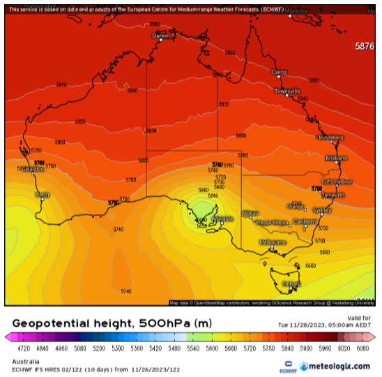
Figure 1: ECMWF 500hPa (18,500ft) thickness chart showing upper low over SA @ 4:30am local on 28/11/23. Also note ‘omega’ like block pattern with upper ridge in between the two upper lows. Source - Meteologix
Meteorological Discussion:
In short, an upper low is currently wandering north through the Bight. Across the northern flank of this is a developing mid to upper level jetstream. A large high is centred well south of the mainland across the Southern Ocean but extends a surface ridge across the Bight. A weak surface trough is situated over the NE and eastern portions of SA and this will deepen as the upper low starts to track eastwards this afternoon (27th). With the interaction of these two increasing throughout the
afternoon and evening, a focus of convergence in the low levels and strong upper forcing from aloft caused by the upper low as well as steepening lapse rates should see showers and thunderstorms develop across a swath all the way from far NW NSW down in an arc across the NE Pastoral, Flinders, Upper North, Southern NW Pastoral, Eyre Peninsula and parts of the Lower North and N Yorke Peninsula. This activity will be higher based at first and extend S-SE across the N Adelaide Plains, parts of the Riverland, Yorke Peninsula and gulf waters before the upper low moves closer.
Throughout the evening and more so after midnight, these showers and thunderstorms will increase in coverage across the aforementioned areas, but further west and south this will tend to more rain areas and embedded thunder with moderate to heavy rain at times in a slow steering environment. Most of this will be towards the southern portions of Yorke Peninsula and associated gulf waters but heavy falls are likely in training and slow-moving thunderstorms further north across the N Adelaide Plains, Lower and Upper North and N Yorke Peninsula where the convective parameters are greater and thunderstorm activity stronger and more focused (severe thunderstorms likely). Hail (1-2cm) is likely in these stronger cells as well as intense rainfall which is likely to produce localised flash flooding at times.
By daybreak the upper low will be centred somewhere near Whyalla with the surface trough still to the east with NE-S surface winds bringing back greater amounts of low-level moisture from NSW. With solar heating, it won’t take long for renewed surface-based development to occur, with a focus across the Lower and Upper North (especially ranges/elevated terrain), Riverland, Mt Lofty Ranges (chiefly northern), N Mallee and some of the southern to central Mallee. Thunderstorms will be lower based with a greater chance of intense rainfall. The highest risk of severe thunderstorms will be over the Riverland, Southern NE Pastoral and eastern portions of the Lower and Upper North where hail is again a risk in stronger cores in the order of 1-3cm.
Now I know the SE Districts, in particular in and around Naracoorte copped significant flash flooding from the last event with a double whammy of slow-moving thunderstorms (more detail on this in December outlook). The risk this time is far less to basically nothing at all as the ridge should hold activity north of here.
I should make a note for any of you in western to central NSW on the 28th that there is a risk of high-end severe thunderstorms with intense rainfall causing flash flooding, large to giant hail and damaging to destructive winds. There is also a slight risk of a tornado in the strongest left moving supercell towards the northern end of the line or any storm that keeps itself isolated from the main clusters/squall line so please keep an eye out in this area tomorrow afternoon especially.
Rainfall:
Rainfall with this system will be highly variable due to both the slow-moving nature of the storms and also the convective nature.
Generally, a broad chunk of falls from areas affected will be in the 10-20mm bracket though towards northern and western Eyre Peninsula, totals drop off as activity is more isolated. Most locations south of a line from Kingscote to Victor Harbor to Bordertown will see less than 5-8mm with perhaps only isolated dumps to 10-15mm. The main two focus areas are the foot of and western Yorke Peninsula and far eastern Eyre Peninsula where falls may be closer to the 20-30mm bracket with isolated 40mm dumps. The other is the Lower and Upper North and Riverland/S NE Pastoral where 25-35mm falls will be more common with isolated 50-80mm dumps in thunderstorms causing flash flooding. This risk is greatest tomorrow afternoon on the 28th in these areas whereas the risk for Yorke Peninsula and Eyre Peninsula is more through the evening of the 27th and early hours of the 28th.
Victoria
I should make a note also that as the upper low moves east, the 28th and also the 29th is where the focus is here. NW VIC especially on the afternoon and evening of the 28th sees showers and thunderstorms rotating around the upper low with a flash flooding risk especially. These showers and thunderstorms will spread east across the north of the state before tending to rain and spreading SE-S across Central, southern and eastern portions of the state. High moisture levels lingering combined with solar heating will see renewed showers and thunderstorms rapidly develop on the 29th with more severe thunderstorms likely across the north central and northern country areas in particular with rain areas further east and south. Similar rainfalls in these storms can be expected to the ones in SA on the 28th with 20-30mm generally however isolated rapid dumps of 50-80mm are possible in severe thunderstorms.
That is all for now, I hope you can dodge the worst of it for those that are still harvesting. But for those that are done, I am sure any rainfall will be most welcome.
Stay tuned for the December outlook where I will go into more detail about why we are experiencing this sudden uptick in thunderstorms across much of the eastern half of the country.
Link to temporary blog website: https://farmweathersa.blogspot.com/
Happy Farming and Cheers from The Weatherman
*Note – For interest only, all thoughts are of The Weatherman and may not be reproduced without my consent.


Comments
Post a Comment