November outlook 2023 SA
November outlook 2023 SA
*Forecast prepared between November 1st-5th 2023
Review:
G’Day everyone, another month of the year down and November is now upon us, which no doubt many of you are extremely busy in with harvest in full swing, certainly much earlier than this time last year.
October was not a kind month, both for being dry but also for the very nasty late frost that came with it with the morning of the 26th being the worst with a snap frost across many locations and I will expand on that below shortly. The general trend for the month was a mobile pattern however aside from some thunderstorm activity on the evening of the 2nd with some fortunate rain areas across the southern NE Pastoral and weak fronts, significant rainfall simply didn’t happen with most changes being dry and windy before new ridges pushed in behind.
The main event however was the frost on the morning of the 26th which was a snap frost and, in some locations, caused a rare but devastating black frost where parts of the Clare Valley and Eden Valley were badly hit. Keith West recorded a minimum of –3.3C that morning (followed by –3C the next) however I suspect there were some far colder pockets locally down from –4C to –6C. I firstly want to sincerely apologise for not even mentioning frost in the last update, for some reason I did not add it into the forecasts despite jotting down notes beforehand. It did look fairly cold with the classic setup of the cold pool being rapidly replaced by a large high pressure with that cold, dry air sinking quickly however I was taken aback by how severe some areas were, I’d have expected temperatures to about –3C but not –6C. I hope the damage for you wasn’t too bad and the grain was not moist however certainly any vineyards were very badly decimated.
Taking a look back at the rainfall charts for the month and it was clear that for a vast majority of the state, it was a poor month. Through Figures 1 to 3 below there is a clear trend of below to very much below average with only the Southern NE Pastoral in a very small area coming at around average rainfall largely due to a single event. Reliable rainfall to help finish off crops simply was not to be and can be attributed almost entirely to the Positive IOD with some small help from El Nino.


Looking back at the outlook for October this is what we had:
“October as a whole is likely to come in with below average rainfall, with many areas of very much below average rainfall. The most likely area for this are the NW of the state and also Kangaroo Island, Eyre Peninsula and parts of the Lower SE. The Upper North may do a little better mostly from this system but still fall largely short of average. The Central and Eastern Districts in general should see below average rainfall, with perhaps only the far eastern/SE corner of the NE Pastoral and some of the Riverland coming close to average with lingering moisture feeding into eastern state systems.”
All in all, fairly close to the mark with the broader drier trend further west and the best areas in the south of the NE Pastoral. Perhaps however the NE corner of the state was missed as that did come in only just below the average.
Meteorological Discussion:
There is a distinct change in the pattern to come for November but it is more a case of the move from the extreme mobility of October to a more traditional November, a month that is dominated by troughs and thunderstorms across the nation and this year it will be focused over the north central to eastern parts of the country as the easterly dip really fires up. A big reason for this will be a persistent amount of ridging and high pressure centred well south allowing moisture to feed in from the Pacific into this quasi-stationary trough which is essentially a dryline like the USA see – moist on the Eastern side and dry on the western side over a tight gradient. Until now, very strong westerlies and colder air have hindered the formation of this trough but now, despite cooler than average waters off QLD, a smaller area of much warmer than average water right off the coast of NSW is helping add some moisture to this trough from those easterlies. This combined with lingering cold air aloft and broadscale forcing from shortwaves extending from the west is creating an oscillating environment of thunderstorms where some days they are isolated but others more scattered with numerous severe thunderstorms including large hail, damaging to destructive winds and intense rainfall. Expect this to dominate the weather over QLD (chiefly SE QLD), NSW (eastern half) and the eastern to NE portions of VIC. NSW is probably in the most favourable area where many areas needing rainfall should be getting it, albeit in a spasmodic manner from a strongly convective signal.
With a continued influence of the Positive IOD (though it should begin to slowly weaken in November), troughs extending from the west into SA will typically be starved of moisture. This dry interior of WA will foster plenty of heat so I’d expect many hot days in November ahead of these troughs, with two main timeframes likely, the first being around the 10th-11th and then a greater potential for longer lived heat towards the last week or so of the month or from about the 20th where by then, the WA heat low combined with upper ridging direct a lot of heat SE and E across the interior of the country with those troughs dragging that down allowing potential for a few 38-42C days across areas as far south as Adelaide. Now this is not unusual for November however I expect above average temperatures by the end of the month for pretty much the entire state as well as below average rainfall. Moisture at least by the last portion of the month should be pushing across the Top End and down into the WA Heat trough with a little more ease than it currently is fueling diurnal thunderstorms amongst this heat.
I’ve made mention in previous outlooks that I expect an uptick in thunderstorms this month and that is still looking likely, with a focus on the second half of the month broadly but this will take a while to show its hand in SA as opposed to other states due to our state being starved of moisture. Nevertheless, some isolated thundery potential exists in the east/NE with westward moving easterly dip trough on the 8th as well as another on the 10th from a trough extending from the west. These thundery signatures will linger over the NE and NW Pastoral for more days due to the lack of ridge influence where as more southern agricultural areas will struggle to see long periods of potential due to far stronger ridging out of the SW with high pressure still dominating the waters to our south setting out fresh to strong SE-E winds at times, especially about coastlines in the afternoon with seabreeze re-enforcement as well as on the western slopes of the ranges where gully winds will fire up (they have already been quite active in the last few days).
Now in terms of current events we have that developing easterly dip (which is a term used for the Eastern Australian trough that develops over the warmer months just like the WA Heat Trough. The shape of Australia determines this due to the western and eastern sides of the country bending south with the Bight might further north. This natural causes high pressure to settle in the Bight and troughs to deepen over the warmed land further east and west around those highs. This is your status quo and expected weather on any given day and a good reason why SA is the driest state in the nation. In drier patterns like we currently have this rings especially true as the ridges have more power. Thunderstorms, some severe have been firing up in this across the eastern states in the last few days and this should continue for many more yet. The 6th should see isolated afternoon thunderstorm activity across VIC however the peak will be the 7th and 8th with scattered afternoon and evening showers and thunderstorms across much of the state, but a focus on the ranges through the central and eastern portions of the state. The 9th will see that shift to mostly the eastern half of the state only.
Back in SA, this easterly dip will move west to be centred over the far western parts of VIC by the 8th which should allow some moisture and instability to filter west into SA resulting in isolated afternoon and early evening showers and thunderstorms across the NE Pastoral, Riverland parts of the ranges of the Upper North. There also may be some isolated shower and thunderstorm activity extending from the west of the state as a deepening trough comes from WA across mostly the interior of the state, with a weak Bight ridge just holding it north. By the 10th that trough will deepen and link up with a front passing below the state and extend eastwards with heat coming down ahead of it with temperatures in the mid to high 30’s across most districts with low 40’s across the interior and possibly anywhere north of about Clare in latitude. This trough will be moisture starved but some mid-level moisture through the evening may see some isolated thundery showers though their strength will be sapped. Immediately behind this a strong high pressure centred well below WA will extend a much cooler fresh SW to S change from a strong ridge up through the Bight on the 11th and 12th steering that trough east and contracting that weak instability further north and east into the eastern states.
From here on in till mid-month this ridge will remain slow moving although the NE corner of the state should continue to receive some thunderstorm activity for a couple more days before a new deepening trough and low with increasing showers and thunderstorms moves down out of WA over the Far West and NW of the state.
Overall, the monthly rainfall outlook for November continues to see below average rainfall but the signatures will not be as widespread as October. Areas that should do better closer to average include the NE corner of the state from the easterly dip as well as the NW and far west with influence from the WA heat trough thunderstorm activity. Most other remaining districts should see below average rainfall with again some very much below average totals over some southern agricultural districts including the Mt.Lofty Ranges, Yorke Peninsula, Kangaroo Island and the SE Districts.
Climate Drivers:
The Pacific has continued its slow amble towards a moderate El Nino with some slight progress in the last 2 weeks as we can see when we refer to Figure 4 below. The eastern and central eastern portions are now fairly consistent with the warmer than average tongue without that gap that has been present as recent as two weeks ago. This is due to the warmer water in the sub-surface finally making it to the surface and extending west however I don’t expect a great deal more warming from here on in, maybe another 5-10% before we see a peak in the El Nino event in the oceans. It is not going to be a strong event but that has not been expected for quite some time now. Trade winds are winds have been a little weaker which has allowed the warmer water to surface with MJO bursts of weak to moderate strength across the basin but once again, nothing strong or significant.
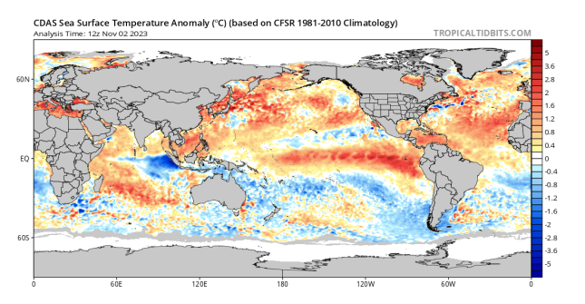
Moving on to the Indian, the Positive IOD is still in full swing and if anything after a subtle weakening last week, we have seen it double back down with some renewed upwelling off Sumatra and Java evident by the 7-day anomaly chart in Figure 5. This shows that the oceanic circulation in the Indian is still strong and has not weakened with the large high pressure across Australia in the past 2 weeks largely to blame triggering strong trade winds and keeping that ocean upwelling in full swing. This in turn will continue to starve the country of moisture out of the NW despite recent warming in the shallower seas off WA, it is known that this area does not have as much impact on the broader climate than the area off Sumatra despite being closer. It has more local affects to the WA and NT areas.
The MJO is weak at this point in time but should be gathering a little strength as it once again pushes into the Eastern Pacific and the America’s in the next week however no significant Westerly Wind Bursts are expected. This lull in MJO activity to the west and over tropical Australia is really hurting the build-up with rainfall still very minimal due to lots of dry air around and a lack of deeper moisture. I do expect thunderstorms to increase markedly from about the 6th of November as moisture finally moves in with stronger troughs oscillating across the Top End.
Now the SAM has been sitting in a neutral zone with a lot of highs and lows passing below us in that mobile pattern I mentioned earlier however this will take a step towards Positive in November allowing heat to build inland with increasing moisture across the Eastern portion of the country due to the combination of strong highs to the south and easterly dip troughs in the east fueling an increase in showers and thunderstorms for the eastern states. This is fairly typical of November in any given year, but we still have stronger than normal westerly winds through the middle and upper levels for the time being, so I do not expect the SAM to stay positive for a long period but sit in the neutral to positive area. Negative bursts are not likely this month, but I can potentially see a short spell in December as the next round longwaves push into our window.

Districts:
Eyre Peninsula
Becoming warm to hot throughout though milder on the coastal fringes as a trough develops from the west. Isolated afternoon thundery showers possible on 8th with minimal rainfall. Trough extends east on 10th with hot to very hot conditions ahead of it before bringing a cooler fresh SW to S change with further isolated thundery showers again with minimal rainfall. Strong new ridge developing behind with fresh to strong seabreezes during the afternoons and coastal SW-SE flow as large high to SW remains slow moving. Potential for another trough just after mid-month with some further thundery shower activity but again minimal rainfall. Rainfall for period 1-3mm with possible 5mm local falls in any stronger cores but otherwise many locations will see less than 1mm.
Upper North
Becoming warm to hot throughout as a trough develops from the west and another from the east. Moderate gully winds at times on 8th and 9th. Isolated afternoon showers and thunderstorms about the ranges and elevated terrain towards the NE of the district on 8th but minimal rainfall. Trough in west extends east on 10th with hot to very hot conditions ahead of it before bringing a late cooler fresh SW to S change with isolated thundery showers again with minimal rainfall. Strong new ridge developing behind with fresh seabreezes during the afternoons and coastal SW-SE flow as large high to SW remains slow moving. Potential for another trough just after mid-month with some further thundery shower activity but again minimal rainfall. Rainfall for period 1-3mm with possible 5mm local falls in any stronger cores but otherwise many locations will see less than 1mm.
Lower North
Becoming warm to hot throughout as a trough develops from the west and another from the east. Moderate gully winds at times on 8th and 9th. Isolated afternoon showers about the ranges and elevated terrain towards the NE of the district on 8th but minimal rainfall. Trough in west extends east on 10th with hot conditions ahead of it before bringing a late cooler fresh SW to S change with isolated thundery showers again with minimal rainfall. Strong new ridge developing behind with fresh seabreezes during the afternoons and coastal SW-SE flow as large high to SW remains slow moving. Potential for another trough just after mid-month with some further thundery shower activity but again minimal rainfall. Rainfall for period less than 1-2mm with possible 3mm local falls in any stronger showers but otherwise many locations will see less than 1mm.
Yorke Peninsula
Becoming warm to hot throughout though milder on the coastal fringes as a trough develops from the west. Trough extends east on 10th with hot conditions ahead of it before bringing a cooler fresh SW to S change with isolated thundery showers with minimal rainfall. Strong new ridge developing behind with fresh to strong seabreezes during the afternoons and coastal SW-SE flow as large high to SW remains slow moving. Potential for another trough just after mid-month with some further thundery shower activity but again minimal rainfall. Rainfall for period less than 1-2mm otherwise many locations will see little if any rainfall.
Kangaroo Island
Becoming warm throughout though milder on the coastal fringes as a trough develops from the west. Trough extends east on 10th with warm to hot conditions ahead of it before bringing a cooler fresh SW to S change with isolated thundery showers with minimal rainfall. Strong new ridge developing behind with fresh to strong seabreezes during the afternoons and coastal SW-SE flow as large high to SW remains slow moving. Potential for another trough just after mid-month with some further thundery shower activity but again minimal rainfall. Rainfall for period less than 1-2mm otherwise many locations will see little if any rainfall.
Adelaide Plains
Becoming warm to hot throughout as a trough develops from the west and another from the east. Possible isolated shower on 8th. Moderate gully winds at times on 8th and 9th. Trough extends east on 10th with hot to very hot conditions ahead of it (chiefly outer north) before bringing a late cooler fresh SW to S change with isolated thundery showers with minimal rainfall. Strong new ridge developing behind with fresh to strong seabreezes during the afternoons and coastal SW-SE flow as large high to SW remains slow moving. Potential for another trough just after mid-month with some further thundery shower activity but again minimal rainfall. Rainfall for period less than 1-2mm with possible 3mm local falls in any stronger cells but otherwise many locations will see less than 1mm.
Mt.Lofty Ranges
Becoming warm to hot throughout as a trough develops from the west and another from the east. Possible isolated shower on 8th. Moderate gully winds at times on 8th and 9th on western slopes. Trough extends east on 10th with hot conditions ahead of it before bringing a late cooler fresh SW to S change with isolated thundery showers with minimal rainfall. Strong new ridge developing behind with fresh to strong seabreezes during the afternoons and coastal SW-SE flow as large high to SW remains slow moving. Potential for another trough just after mid-month with some further thundery shower activity but again minimal rainfall. Rainfall for period less than 1-2mm with possible 3mm local falls in any stronger cells but otherwise many locations will see less than 1mm.
Riverland/Mallee
Becoming warm to hot throughout as a trough develops from the west and another from the east. Isolated afternoon showers and thunderstorms about the Riverland on 8th but minimal rainfall. Trough in west extends east on 10th with hot to very hot conditions ahead of it before bringing a late cooler fresh SW to S change with isolated thundery showers again with minimal rainfall. Strong new ridge developing behind with fresh seabreezes during the afternoons towards the Southern Mallee. Potential for another trough just after mid-month with some further thundery shower activity but again minimal rainfall. Rainfall for period 1-3mm with possible 5mm local falls in any stronger cores but otherwise many locations will see less than 1mm.
Upper SE
Becoming warm to hot throughout as a trough develops from the west and another from the east. Isolated afternoon showers on 8th possible. Trough in west extends east on 10th with hot conditions ahead of it before bringing a late cooler fresh SW to S change with isolated thundery showers again with minimal rainfall. Strong new ridge developing behind with fresh seabreezes during the afternoons and coastal SW-SE flow as large high to SW remains slow moving. Potential for another trough just after mid-month with some further thundery shower activity but again minimal rainfall. Rainfall for period 1mm or less for the most part.
Lower SE
Becoming warm to hot throughout as a trough develops from the west and another from the east. Isolated afternoon showers on 8th possible. Trough in west extends east on 10th with warm to hot conditions ahead of it before bringing a late cooler fresh SW to S change with isolated thundery showers again with minimal rainfall. Strong new ridge developing behind with fresh to strong
seabreezes during the afternoons and coastal SW-SE flow as large high to SW remains slow moving. Potential for another trough just after mid-month with some further thundery shower activity but again minimal rainfall. Rainfall for period 1mm or less for the most part.
Western VIC
Becoming warm to hot throughout as a trough develops from the west and another from the east and overhead. Isolated to scattered afternoon showers and thunderstorms on 7th-8th in the far E of all 3 districts, with activity much more isolated for the remainder. Locally severe thunderstorms in far east/NE of the SW District on 8th with large hail, intense rainfall and damaging winds from vigorous afternoon convection. Trough in west extends east on 10th to 11th with warm to hot conditions ahead of it before bringing a late cooler fresh SW to S change with isolated thundery showers but with minimal rainfall. Strong new ridge developing behind with fresh to strong seabreezes during the afternoons and coastal SW-SE flow as large high to SW remains slow moving. Potential for another trough just after mid-month with some further thundery shower activity but again minimal rainfall. Rainfall for period 1-3mm in western half of districts however with thunderstorms in far east, local falls of 20-30mm are possible in a short space of time, especially on the afternoon of 8th but possibly also the 7th.
Final Notes
- Positive IOD has now peaked with a slow wane through November
- El Nino not far off a peak either with a slow wane through December and further into January as easterly winds begin to fight back across the Pacific, largely thanks to strong highs south of mainland Australia
- Thunderstorms firing up in easterly dip across QLD, NSW, VIC – typical of November
- Top End thunderstorms increasing from 6th and especially about 10th with deeper convection
- Remaining dry in SA for most part as strong high pressure and ridging dominates waters to south keeping unstable troughs west and east although moisture will increase inland, especially in second half of month
- December should see further uptick in thunderstorms across the nation as heat and moisture continues to increase
- Many hot days ahead of troughs in second half of November and also early December
- Typical summer for much of SA but with building moisture across tropics as seas warm up and El Nino breaks down properly leading to much better rainfall for 2024
- Link to temporary blog website: https://farmweathersa.blogspot.com/
- Happy Farming and Cheers from The Weatherman
*Note – For interest only, all thoughts are of The Weatherman and may not be reproduced without my consent.


Comments
Post a Comment