Quick Update SA two fronts with rain areas July 22-25th 2022
Quick Update SA two fronts with rain areas July 22-25th 2022
G’Day everyone, just a quick update on the fly for these two fronts inbound, I touched briefly on them in the mid-month update with the first to bring some mid-level showers and then the second to be sliding but potentially squeeze the jetstream with some patchy rain areas but holding mostly north of southern ag areas. The good news at least (as I’m sure many of you are aware of now) is that there have been some handy upgrades, moreso over the Eastern to SE Districts.
So, what has changed in the last week? The main difference has been the resultant moisture leftover from the inland upper low over Central S QLD/N NSW where some good 25-50mm falls have occurred. The large high-pressure cradling this has developed an impressive low level jetstream which has angled the moisture in. Refer to figure 1 for the first system.
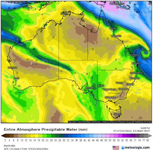
Figure 1: Entire Atmospheric Precipitable Water chart for 09:30pm local on 22/07/22 - source Meteorologix
In Figure 1 above we can see the green shaded area connected from the current low off QLD and back into SA and W VIC/NSW. There is also a thin slither connected to the NW, but this is as good as cut off from this point on. The cold front (weakening as it is) is located over Eastern SA at this time and is supplied with enough moisture to lift and make rain areas. The slow-moving nature of the front, held up by the large high to the east means the rain areas will be slow moving though not heavy so reasonable gradual accumulations will occur, especially over the E border of the Mallee, Upper SE and Lower SE and into a large chunk of Western VIC.
The second system of interest then stands up on the 24th in the Bight and gains a little bit of a negative tilt. The jetstream aloft will get a nice squeeze and moisture will condense out ahead of the front into a mid-level cloudband. See Figure 2:

Figure 2: Entire Atmospheric Precipitable Water chart for 12:30pm local on 24/07/22 - source Meteorologix
In Figure 2 above we can see firstly we still have a lingering green shaded area over E/NE SA, W NSW & SW QLD connecting back SW into Central and Eastern SA districts. This is leftover from the previous system 2 days prior that has not been cleaned out by a large high or cold air blast from the SW. The front to the west with jetstream then brings down that second infeed condensing into a patchy rainband over W SA with possible isolated thunderstorms also given the strength of the lift and slight negative tilt.
You can see the darker green area of this higher moisture content over W SA with the cold front following just behind with lighter green over the W Bight areas. If this system was weaker like it originally looked then I think the jetstream orientation wouldn’t have been angled as SE as it is and instead be more ESE across northern areas with that light patchy rain. At least we have some form of trigger now. This system will then hit that E moisture once again for more handy falls out east especially and into W VIC/Lower SE SA.
So, in short, patchy light rain areas increasing east of the ranges and especially the Murray into eastern border and W VIC from first system.
Second system areas of rain and isolated thunderstorms extending from the NW thickening to a general band of rain as the front catches up over Central and Eastern Districts followed by scattered colder air showers, chiefly south of about Adelaide’s latitude and certainly more over KI and the SE Districts. The sliding nature of the second system with negative tilt will mean a lack of SW-NE penetrating showers further north and streams setting up. A second slider front may clip the SE of the state on 28th as a new high becomes established.
Longer term, no changes, still seeing a much-improved August with gruntier systems and NW support.
Rainfall:
For the combined systems most districts south of about Clare should see 5mm or more. Exceptions to this will be parts of the Eyre Peninsula where the band will not have thickened up as much so more 2-5mm there. Totals should increase with southern an eastern extent (bar some immediate rain shadowing off the Lofties). 5-8mm over Yorke Pen with 8-15mm over Adelaide area and KI. The Adelaide Hills should do much better with totals to 25mm. But the most useful impact will be east of the ranges with a general 8-15mm across the Mallee, increasing to 12-18mm closer to the Eastern border up to about the Riverland. Totals over the Riverland will mostly sit in the 3-8mm range. The Upper and Lower SE then see the best general falls in the 18-30mm range with possible 35-40mm totals over the Lower SE. Western VIC will be similar with solid 20-30mm totals, but these decrease towards the northern Mallee with 3-8mm totals like the Riverland. August outlook to follow in around 10-12 days. Hopefully you can get something useful!
Link to temporary blog website: https://farmweathersa.blogspot.com/
Happy Farming and Cheers from The Weatherman

*Note – For interest only, all thoughts are of The Weatherman and may not be reproduced without my consent.


Comments
Post a Comment