July 2022 update SA
July 2022 update SA
*Forecast prepared between July 15th-16th 2022
Review:
G’Day everyone, the middle of July is already upon us, and I have to say the first half of the month has been pitiful for rainfall, not that it was unexpected from the outlook, but I’d say it’s even underachieved in parts, my place in Adelaide has only had 3.4mm so far. Dynamically, the east coast has been dominated by wet conditions caused by multiple ECL’s which have acted as a roadblock to everything else to the west. At the same time, the SAM has been positive with highs favoring a more southern anchor completely smashing the westerly belt down plus the MJO has been moving away again and weak over the Top End and into the Pacific. Moisture continues to feed down from the very warm Coral Sea (see climate drivers section) into lows over the Tasman further assisted by these frequent upper troughs that wander up above the surface high pressure systems. It is essentially a rinse and repeat pattern which no doubt the east coast are also sick of with far too much rain.
Slight to moderate frost has been more common over the first two weeks with an especially cold night in unique places on the morning of the 6th with Ceduna recording –3.9C, Ernabella a chilly –4.9C and Pallamana –3C. Yunta as usual was right up there with –4.4C. Further moderate frost occurred on the 10th, although not as widespread as the 6th, but the eastern and central districts this time took a harder hit with some negative temperatures across the northern suburbs of Adelaide and out further north over the Plains.
A weak front moved through on the 11th with minimal impact for more western and northern ag areas but actually was useful east of the ranges for a change with better than expected totals in the Mallee and parts of the Riverland, mostly thanks to a secondary trough pushing up behind the front on the 12th from the SW with no shadowing. Falls of 5-10mm were recorded through the Eastern and Northern portions of the Mallee though still patchy but nice to have a small win in an overall dry pattern.
Behind this further frost occurred from 13th to 14th, especially across the Lower and Upper North as well as parts of Northern Yorke Peninsula.
Meteorological Discussion:
Currently on the morning of sat 16th we have a cold front approaching the coastline with a band of showers. Ahead of this front there is quite a bit of mid-level instability with some dynamic lift aloft. Visually, the mid-levels are unstable with fairly deep Altocumulus so I would expect some pre-frontal showers, possibly some heavier ones against the ranges at times before the main front closes in sending that band of showers through to most districts though more scattered further north and east and then isolated towards the Upper North and Riverland. The front will weaken as it crosses the coastline however some heavier showers are still likely across KI, Mt.Lofty Ranges and the SE Districts. A brief isolated thunderstorm cannot be ruled out about southern coasts.
Behind the front later on the 16th, we will see an established cold and blustery SW airstream around the back side of a deep low centred well south of the mainland. A secondary cold front will advance rapidly up from the SW early in the morning on Sunday 17th, reaching KI by mid-morning and Adelaide approx after lunch with another general band of showers sweeping in. A colder blustery SW flow will accompany this front driving showers further inland and with a better angle for penetration right up into the Mallee, eastern border and parts of the Riverland also so this little front should at least deliver some handy falls in parts of the Mallee, but more will no doubt be needed. Small hail is also likely about the SE Districts.
After this a large high will quickly move in over the waters to the south to be centred west of Tasmania for a few days. Aloft, the remnant colder air from the rapid front on the 17th will continue to surge north as a sharpening upper trough and interact with the warm moist air waiting over the Coral Sea. This unusually high amplitude upper trough will then easily generate more rain areas and start to form another East Coast Low although not in the traditional position, but up off the QLD tropical coast before this drifts slowly SE. Heavy rain once again will be a feature along the QLD coast and also into Central QLD (not as high totals here). The inland rain will further act to keep soils moist and keep inflows into both the Lake Eyre Basin and the Darling River high. As an addon to this, water levels are already rising through the Riverland thanks to high flows down both the Murray and Darling system. I expect much higher levels by the end of the year and into 2023 which is excellent for the overall health of the system.
Unfortunately, with the high behind that colder air, frost will again rear its ugly head, especially so this time east of the ranges and SE districts away from the effects of low cloud. The 19th-21st period will likely see some very cold minimums 3 in a row with the surface high moving only slowly eastwards during this time to be centred over the Tasman Sea by the 21st. A ridge with extend back over SA with lighter winds and sinking air aiding to the cold with the already cold uppers aloft, this 3-day period of sinking will drive that cold, dry air to the surface so please take heed, widespread slight to moderate frost is likely, with possible isolated heavy pockets in prone cold spots. A second block may appear later in month from 26th-29th approx.
The large high will weaken off and move eastwards to be met by sliding cold fronts after the 21st. They should have a good impact into the SW portions of WA but be blocked off by the time they get near SA which is unfortunate and once again due to the wretched block off the east coast with that aforementioned low still holding up the traffic. This is a repeating pattern that has really nailed the dryness for SA this month. I have to say I did expect a better finish to the month and whilst we will get a nice little one two punch from 16th-17th, it’s nowhere near what is needed with the sheer persistence of this blocking being quite surprising to be honest, but we are here to learn and understand and to find out why to be better prepared for next time.
To round out the month, I am expecting multiple attempts to form a cut off low or two near WA and below but with fairly stout high pressure around it so this will likely favour more rainfall for SW WA with a weaker version of events pushing into SA with the squeeze in the jetstream at least likely to try and start some light patchy rain across the interior around the 24th but not a lot in it.
The good news is that at least with this block in July that the moisture and lift is still increasing in the Indian with a return to average to above average rainfall likely through August to October. I also often find that one dry month can often flip the other way quite quickly into a wet month right after. But I will have a deeper dig on that one and report back for the August outlook (purely going off the ol’ memory for now).
Climate Drivers:
Now we haven’t had to wait long before La Nina decided to fight back from being officially declared over. Whilst we are still technically in a cool neutral, the odds of a triple dip are in my eyes almost $1.01. Solid cooling has already resumed off Peru thanks to the Humboldt Current re-invigorating the cold-water upwelling. Strong trade winds from both hemispheres have been dominating in recent weeks over the Pacific. Combined with this, warming over the Coral Sea has been increasing with significant warmer anomalies now present. It comes as no surprise that this area has now been the chief area of moisture feed over the entire Southern Hemisphere with vast quantities of tropical air flowing southwards. I will expect some of this heat to filter westwards through the Indonesian throughflow Current into the Eastern Indian over the next 2-3months, strengthening the negative IOD. All of this points to another wet spring and summer for the Eastern Seaboard and in general, a fair amount of Australia, but especially the eastern half
.
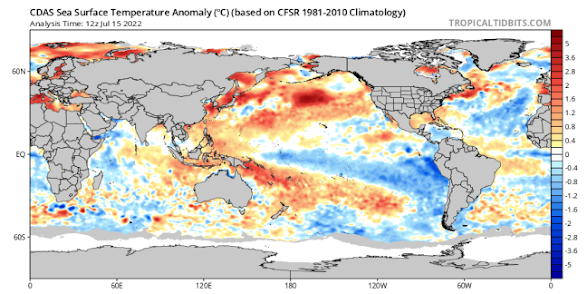
Figure 1: Current SST anomalies – source Tropical Tidbits https://www.tropicaltidbits.com/analysis/ocean/
The Indian has also made a move just like the Pacific with warming in the east and cooling in the west. The result has seen the IOD now move to –1.14C which is the lowest value since 2016. A proper west to east gradient is setting up although it has properly locked in yet, but these sorts of values will really get things going now. Convection continues to be consistent and prominent to the W/SW of Java with numerous thunderstorms, as well as diurnal thunderstorm activity over the islands and mainland itself. The SE trades are nowhere to be seen here and instead are all over the Pacific pointing to convergence and uplift across Eastern Tropical Australia and again over the Eastern Indian. The mainland of Australia itself remains stuck in the middle but this will not last too much longer once our block releases from the East.
I am expecting the Negative IOD to show its hand properly from August through to September and possibly November given July has been dry. In the last update I mentioned about more thunderstorms through spring and early summer and this I expect to most certainly be the case, more so than last season which was under par during spring (but did get going nicely in January).
Moving along to the MJO and this has been weakening into phase 5 and 6 over the mainland and western Pacific. Nevertheless, there has still been enough grunt to promote tropical convection over and near the Coral Sea (certainly aided by the above average SST’s). The MJO will stay fairly weak for the meantime before re-emerging with more strength back towards phase 7 and 8 on the other side of the globe in late July. Our next pass should be sometime in early to Mid-August all going well.
The SAM has been a real pest of late, holding strongly positive with only brief dips to neutral values. Strong high-pressure systems up to 1040hPa sitting well south have not helped this index and it shows the amount of sinking air over the mainland right now sitting behind that wall of uplift over the Eastern Seaboard. This index will release back to neutral values through late July and August with a greater chance of negatives from mid to late August.
Districts:
Eyre Peninsula
Cold front moving through on 16th with scattered showers, more frequent about the tip of Lower Eyre Pen. Secondary front with more SW angle on 17th with a band of showers and colder air in blustery SW flow easing later. New large high moving in after with slight frost risk from 19th-21st. Sliding fronts squeezing isobars and freshening N winds on 22nd with some mid-level showers only likely later. Slight chance of mid-level showers or patchy rain in north around 24th but not a lot. Repeat fronts sliding right through till end of month with high pressure attempting to take hold, secondary slight frost window 26th-29th. Rainfall for period 3-5mm, isol 8-12mm about tip of Lower Eyre Pen. Totals decreasing to less than 2mm in north.
Upper North
Cold front moving through on 16th with scattered showers, more frequent in south and about higher terrain, but much more isolated in the north and east. Secondary front with more SW angle on 17th with a band of showers and colder air in blustery SW flow easing later. New large high moving in after with slight to moderate frost risk from 19th-21st. Isolated heavy pockets possible. Sliding fronts squeezing isobars and freshening N winds on 22nd with some mid-level showers only likely later. Slight chance of mid-level showers or patchy rain in north/Flinders around 24th but not a lot. Repeat fronts sliding right through till end of month with high pressure attempting to take hold, secondary slight to moderate frost window 26th-29th. Rainfall for period 2-3mm, isol 5-8mm about higher terrain and any streams that setup on 17th. Less than 2mm further north and east.
Lower North
Cold front moving through on 16th with scattered showers, more frequent and heavier in south and about higher terrain. Secondary front with more SW angle on 17th with a band of showers and colder air in blustery SW flow easing later. New large high moving in after with slight to moderate frost risk from 19th-21st. Isolated heavy pockets possible. Sliding fronts squeezing isobars and freshening N winds on 22nd. Repeat fronts sliding right through till end of month with high pressure attempting to take hold, secondary slight to moderate frost window 26th-29th. Rainfall for period 4-8mm, isol 8-15mm about higher terrain and any streams that setup on 17th. Less than 2mm further north and east.
Yorke Peninsula
Cold front moving through on 16th with scattered showers, more frequent and heavier in west and near the foot of the Peninsula. Secondary front with more SW angle on 17th with a band of showers and colder air in blustery SW flow easing later. New large high moving in after with slight to moderate frost risk, moreso in the north from 19th-21st. Sliding fronts squeezing isobars and freshening N winds on 22nd with some late isolated mid-level showers possible. Repeat fronts sliding right through till end of month with high pressure attempting to take hold, secondary slight to moderate frost window 26th-29th. Rainfall for period 4-8mm, isol 8-12mm over the foot and parts of the western coastline. Less than 2-4mm in the north.
Kangaroo Island
Cold front moving through on 16th with scattered showers heavy at times. Secondary front with more SW angle on 17th with a band of showers and colder air in blustery SW flow easing later. New large high moving in after with slight frost risk 19th-21st, chiefly near centre of island. Sliding fronts squeezing isobars and freshening N winds on 22nd with some late isolated mid-level showers possible. Repeat fronts sliding right through till end of month with high pressure attempting to take hold, secondary slight to moderate frost window 26th-29th. Rainfall for period 7-15mm, isol 15-20mm over the western end potentially. Less than 4-7mm in the east.
Adelaide Plains
Cold front moving through on 16th with scattered showers, more frequent and heavier closer to the foothills. Secondary front with more SW angle on 17th with a band of showers and colder air in blustery SW flow easing later. Showers may be heavy at times. New large high moving in after with slight to moderate frost risk, chiefly over outer plains 19th-21st. Sliding fronts squeezing isobars and freshening N winds on 22nd with some late isolated mid-level showers possible. Repeat fronts sliding right through till end of month with high pressure attempting to take hold, secondary slight to moderate frost window 26th-29th. Rainfall for period 7-15mm, isol 15-20mm closer to the foothills. Totals lesser about outer northern and western suburbs in the order of 4-7mm.
Mt.Lofty Ranges
Cold front moving through on 16th with scattered showers, heavy at times during the afternoon. Secondary front with more SW angle on 17th with a band of showers and colder air in blustery SW flow easing later. Showers may be heavy at times once again with possible small hail further south. New large high moving in after with slight to moderate frost risk, chiefly in low lying valleys and also towards the northern ranges from 19th-21st. Sliding fronts squeezing isobars and freshening N winds on 22nd with some late isolated mid-level showers possible. Repeat fronts sliding right through till end of month with high pressure attempting to take hold, secondary slight to moderate frost window 26th-29th. Rainfall for period 12-25mm, isol 30-50mm over known wet spots and higher peaks. Totals lesser about outer northern ranges down to 8-12mm.
Riverland/Mallee
Weakening cold front moving through on 16th with scattered showers, more frequent over SW Mallee. Activity much more isolated over Riverland. Secondary front with more SW angle on 17th with a band of showers and colder air in blustery SW flow easing later. New large high moving in after with slight to moderate frost risk from 19th-21st. Isolated heavy pockets possible. Sliding fronts squeezing isobars and freshening N winds on 22nd. Slight chance of mid-level showers or patchy rain in northern Riverland on 24th but not a lot. Repeat fronts sliding right through till end of month with high pressure attempting to take hold, secondary slight to moderate frost window 26th-29th. Rainfall for period 2-3mm, isol 5-8mm about SW/S half of Mallee and potentially up to eastern border. Totals less than 2-3mm over Riverland for the most part.
Upper SE
Cold front moving through on 16th with scattered showers, more frequent and heavier in the south. Secondary front with more SW angle on 17th with a band of showers and colder air in blustery SW flow easing later. Small hail possible. New large high moving in after with slight to moderate frost risk from 19th-21st. Sliding fronts squeezing isobars and freshening N winds on 22nd. Repeat fronts sliding right through till end of month with high pressure attempting to take hold, secondary slight to moderate frost window 26th-29th. Rainfall for period 4-8mm, isol 8-15mm further south. Potentially only 3-4mm in isolated pockets towards the far N.
Lower SE
Cold front moving through on 16th with scattered showers, heavy at times. Secondary front with more SW angle on 17th with a band of showers and colder air in blustery SW flow easing later. Small hail possible. New large high moving in after with slight to moderate frost risk from 19th-21st. Sliding fronts squeezing isobars and freshening N winds on 22nd. Repeat fronts sliding right through till end of month with high pressure attempting to take hold, secondary slight to moderate frost window 26th-29th. Rainfall for period 8-15mm, isol 15-25mm in the south and about the SW coastline. Potentially only 6-8mm in isolated pockets towards the far N/NE.
Western VIC
Weakening cold front moving through on 16th with scattered showers. Secondary front with more SW angle on 17th with a band of showers and colder air in blustery SW flow easing later. Small hail possible in the SW. Showers much more isolated over Mallee on 16th and later on 17th. New large high moving in after with slight to moderate frost risk from 19th-22nd. Sliding fronts squeezing isobars and freshening N winds later on 22nd. Repeat fronts sliding right through till end of month with high pressure attempting to take hold, secondary slight to moderate frost window 26th-30th. Rainfall for period 8-15mm, isol 15-25mm in the south and about the SW coastline. Potentially only 2-3mm over N/NW Mallee District.
Finals Notes:
· Significant and persistent blocking over Coral and Tasman Seas holding up traffic favouring high pressure over the mainland.
· Delay in Indian impact but not removal, expecting better from August to October once blocking removes and cut off lows return
· Triple dip La Nina looking very likely now with a wet eastern half of country yet again through warmer months
· Increasing humidity for SA through spring and early summer with thunderstorm activity
Link to temporary blog website: https://farmweathersa.blogspot.com/
Happy Farming and Cheers from The Weatherman
Bring on September

*Note – For interest only, all thoughts are of The Weatherman and may not be reproduced without my consent.


Comments
Post a Comment