September outlook 2024 SA
September outlook 2024 SA
*Forecast
prepared between Sept 2nd-4th 2024
Review:
G’Day everyone, spring has indeed sprung, and a very
critical month is upon us, and it will determine for many exactly what can be salvaged from an extremely
unreliable growing season rainfall wise to date. Time to get right into things
and recap a very windy and frustrating August.
The main feature of August was undoubtedly the wind caused
by the three Sudden Stratospheric Warming events with the Longwave Trough also
sitting right under us for the first time this year and staying there. The
problem with all of this is the SSW events essentially ruined the potential of
maximising rainfall whilst it was right in our window by invigorating the
westerly belt so much that it was essentially screaming under us in a venomous
west to east manner without the more usual meandering nature with fronts
penetrating inland more in a SW-NE manner, we simply saw very flat westerlies
which was good for the Lower SE but that’s about it. Significant wind and flood
damage occurred in Tasmania from the frequent cold fronts embedded in that
angry westerly flow and this was the main feature to round out the month. It
was expected however even though I forecast a major drying influence as we
moved north, even the stronger fronts were essentially big wind bags everywhere
bar the Lower SE with spasmodic lighter falls north of here.
Earlier in the month, around the 15th or so, some
useful totals fell over the drier parts of the northern Yorke Peninsula, Lower
and Upper North in a persistent westerly convergence zone. Most totals were
around 10-15mm however some isolated 20mm totals did occur near Kadina to
Alford.
Temperatures were a big problem with much above average
maximum temperatures as well as wind on those warmer days. Numerous all time
heat records were set, notably over the interior with Oodnadatta reaching 39.4C
on the 24th as well as several agricultural stations reaching well
into the low 30’s over the Eyre Peninsula and Upper North. This heat was all
advected south thanks to the SSW event where the dynamic westerly belt drew
significant amounts of air into it ahead of the very large Longwave trough that
parked south of us. It was the warmest overall August since 2009 and very much
reminded me in person of that month where we warmed up very quickly.
Taking a look at the rainfall
charts it tells the story quite well.

Figure 1: August 2024 rainfall deciles -source BoM http://www.bom.gov.au/climate/

Figure 2: August 2024 rainfall percentages -source BoM
http://www.bom.gov.au/climate/

Figure 3: August 2024 rainfall anomalies -source BoM http://www.bom.gov.au/climate/
The tale is
quite clear across the agricultural areas with below average rainfall across
the board. The most notable deviations from the mean were across the Lower Eyre
Peninsula towards the western coastline and unfortunately over the Mallee and
Riverland districts, the latter especially enhanced due to the dominant west to
east nature of all weather systems during August, thus enhancing the rain
shadow. The Pastoral areas did have some rainfall although caution is needed
here given most areas expect little to no rainfall at all in any case. A small
area east to SE of the Flinders did well however but on the broader scale, it
is insignificant compared to the rest of the state.
Taking a look
back at the August outlook noting that I revised expectations at the start of
the month after initially expecting a better month earlier on this year. “Overall,
though, my August outlook is for largely below average rainfall (and note this
is a week later than my normal outlook). I would have expected average a month
or two back with some above average spots but that is likely a bridge too far
unless something enormous finishes the month off- but unlikely. Areas of the
Lower and Upper North, and especially the Riverland and Mallee will see well
below average rainfall. The best chance at least to meet average is across the
southern coastal fringe of the Fleurieu and parts of Kangaroo Island where
frontal activity may skim more frequently but with such a heavy zonal flow,
northern and eastern extent will find it harder to gain good falls.”
Honing in on
the southern coast fringes, the only areas that came closer to the averages
were the Lower SE with the fronts reaching there and a tiny speck of SW KI,
again where fronts clipped. Also, the Adelaide area and western slopes of the
Lofties had enhanced orographics at times but not enough to get average.
Whilst the
revised forecast turned out reasonably ok in the end, I’ll still be calling it
a miss given the expectations months in advance however the drier expected
July, carried Moreso into August for many different reasons.
Just
quickly I thought I’d also share the nation-wide results for August as per
Figure 4 below:

Figure
4: August 2024 rainfall deciles for Australia – source BoM
What stands
out to me is that SW WA was able to receive fronts with assisted Jetstream/NW
cloudband rains over the interior of WA coming off the Indian, so the moisture
was there however that is as far as it got with a much drier area over SA and
VIC. Tassie came back to just above average after a slow start and the Eastern
seaboard of QLD was fairly wet with onshore rains, mostly attributed to a high
amplitude upper trough interacting with moisture off the Coral Sea. SA and much
of VIC really were piggy in the middle with a dominant WNW to W flow which is
very unfavourable for both states, especially VIC due to more land mass to
overcome.
Meteorological
Discussion:
So on to current proceedings and there is a bit to talk
about with how the current pattern is evolving. Right now, we are on the back
end of a sustained period of very active westerlies which has predominantly
given us a lot of wind and minimal rainfall with the
exception of the Lower SE District. With such little SW-NE flow and streams
setting up this season into both the Lower and Upper North from the gulfs and also the Mallee from the Lakes or Coorong area,
the usual sources of mesoscale rainfall that assist marginal areas have been
nearly completely absent. This year's themes for mine have been rain shadow and
no streams and that doesn’t bode well for most of our growing regions.
Currently a trough is allowing moisture to feed in from the
NW forming some sort of cloudband, a long overdue one at that. A band of rain
is expected within this however 80% of it will unfortunately fall over the
water below the state after initially looking like it would come right down
through the agricultural areas. There will be a pushback late but only as it
thins. The best falls are likely to be about the Lower SE and Kangaroo Island.
So generally from the 5th, a very warm to even hot day is likely as northerly winds freshen dragging
all that hot air from the interior right across the agricultural areas with
temperatures in the mid to high 20’s and low 30’s. Areas of patchy light rain
and or mid-level showers are likely, though with a southern bias. Isolated
thundery showers are also likeyl here and there, however most will be sliding
down below the mainland over the water, perhaps clipping KI and Lower Eyre
Peninsula to maybe Yorke Peninsula at times. Into the 6th, the
trough will advance eastwards allowing a cooler fresh southerly change to move
through clearing out the warmer weather. The trough will lag
behind with height (slope to the west) allowing convergence to maximise in
the mid-levels causing a band of rain to gradually thicken up. We should see
general areas of rain across southern coasts and ranges before sunrise,
gradually extending northwards throughout the day. Unfortunately, as it does
so, the rainband will thin resulting in much
lighter falls with northern and eastern extent. Areas north of about Gawler and
generally east of the ranges north of about Murray Bridge will struggle for
anything meaningful this time around.
Once this system clears to the east it will continue across
the eastern states however the falls will remain generally quite light across
the cropping regions of western VIC.
Following this, a new ridge moves in whilst weak fronts pass
quickly to the south of the mainland throwing up a few light showers across the
southern agricultural areas from the 7th to 10th period
but chiefly over southern coasts and ranges as well as windward slopes south of
about Gawler once again. Inland penetration both north and east will be low.
Inland with the gradient aloft tightening and lingering moisture feeding in, a
patchy rainband will form from the 7th to 8th although
falls will remain relatively light within the rainband itself. Isolated
thunderstorms are possible within the band as well.
On the 11th, a weak upper low looks likely
pinching off from the westerly belt and riding more NE but should remain fairly weak. We may see an increase in showers with
this system with a little bit more penetration given it becomes cut off,
however I still am not expecting good falls, mostly light once again however
will watch closely if the system slows down just a little. If this occurs, then
rainfall may uptick a slight amount to include isolated moderate falls.
Right after this a large high pressure looks likely to move
in, feeding off the colder air leftover from the upper low. This high looks to
be situated well south however there will be a frost risk, especially so if it
ends up being a little more north. Given the strong negative SAM phase is
behind us, it is less likely to come north at this stage. Nevertheless, a frost
risk is suggested around the 13th and 14th mornings,
chiefly across the Lower and Upper North and potentially also the Riverland and
Mallee.
Another front or two is possible from mid-month, which may
attempt to make better use of the increasing moisture in the tropics, but
caution is most definitely needed as I have seen this before where the
connection fails to establish beyond a weak level as we work our way back into
slightly better rainfall potential. The Mid-month update may be the most
important yet so I will try to get that one out promptly if possible.
Overall, in terms of a September rainfall outlook I am
expecting a mixed bag across the districts ranging from below average to above
average. The greatest risks of above average are over the Lower SE, Kangaroo
Island and potentially some parts of the outer NW and NE Pastorals. Activity
will drop away to average to below average across most central areas, and down
to generally below average for eastern Districts including the Upper SE,
Mallee, Riverland. The Eyre Peninsula will be around average to slightly below
at this stage but no strong signals either way. So
an improvement on August but not by a great deal.
Improvement in expected more in October and especially November to December,
something which would be considered bad timing.
Climate
Drivers:
There have been a number of very
important changes to the climate drivers over the last two weeks and this marks
an important pivot point in the season. The Pacific has showed a big movement
finally towards
a weak La Nina with a return of the Humboldt Current. I don’t expect
anything strong here or barely even moderate, just weak but we aren’t even
there yet so further work has to be done. Renewed cooling has commended also in
the Nino 3.4 region and extends eastwards essentially to Peru thanks to some
increases in trade winds. Refer to Figure 5 for a better visual reference.
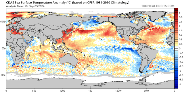
Figure 5: Current SST anomalies – source
Tropical Tidbits https://www.tropicaltidbits.com/analysis/ocean/cdas-sflux_ssta_global_1.png
Around other areas of the Pacific Basin we note the warming
right around the Eastern and Northern portions of Australia and indeed the
waters north of PNG. Very significant warming has been occurring east of China
and near Japan giving extra fuel to the typhoon season there for any recurving
systems. All of this points to a good reservoir of moisture to build as we move
through spring, increasing the odds of moisture being available as systems come
through from the west.
Now the Indian has warmed rapidly in the Eastern IOD box, a
regon just 2 weeks ago that was cooling significantly with a positive IOD
flavour to the pattern. I expected that to be temporary thankfully as the
broadscale pattern is not conducive to forming one but is closer to a negative
IOD. Now some of you may think that’s complete madness and rightly so given how
dry it has been, it might as well have been peak 1994 right now or worse for
some areas. A lot of factors outside of just the IOD has been contributing to
the dryness from the blocking earlier to the SSW and all at the wrong times
causing a domino effect. Now given the severe deficits we have seen so far this
year, a lot of work needs to be done quickly to make a dent in that and whilst
I do still expect improvement from here thanks to the warming eastern Indian
and waters around Aus, the on-ground impacts will filter through only slowly,
gradually building through spring, leaving some areas still wanting more. So,
in essence, patchy rainfall statewide and indeed nation-wide, with some good
areas, some poor areas missing out and some average areas. The IOD I think will
come close to hitting negative by October to November which is when the
greatest moisture levels into SA are likely (November most likely). If that
finally does occur, we would have gone from a Positive like scenario to a
negative, back to a positive and finally finishing near a negative again all
within the one growing season. I honestly can say I haven’t seen that level of instability
in an index before in any given year. Averaging all of it out however, neutral
is where we end up.
Now moving onto the SAM and as we know, August saw an
extended period of westerlies, especially later in the month as the longwave
trough finally moved under mainland Australia and stayed there for the first
time all growing season. However, thanks to the SSW, the westerly belt was
extremely powerful and zonal in nature (zonal meaning west to east flow)
causing poor northern penetration of moisture off the Southern Ocean but due to
the tight pressure and temperature gradients, still delivered strong winds, further
curing stressed crops. The strongly negative SAM has eased back to neutral
levels now. I will not rule out a further negative burst in September with
lingering SSW effects. In 2019, these effects lasted till the end of the year
granted the pattern was quite different then to now with a raging strong
positive IOD.
As far as the MJO goes, we have had a moderate strength
pulse in the last couple of weeks move over however there hasn’t been any
influence. It still is lingering over the top end but weakening and thus we may
see some early season showers over the top end as we are rapidly warming up
with the first signs of heat low development already well underway (and have
been since mid-August infact). We may even see the first storm in the coming
week over the Tiwi islands which is a sure sign of a seasonal change…small
steps in a much larger picture.
Districts:
Eyre
Peninsula
Trough late 5th and 6th moreso
bringing areas of rain, with falls becoming lighter with northern extent on the
6th. New ridge moving in behind clearing rain later
on 6th however a series of weak fronts from the 7th
to 10th passing below the state will keep isolated showers over
chiefly the Lower Eyre Peninsula only. Remaining generally fine further north.
An upper low on the 11th may increase showers during the day across
much of the district before clearing later. New stronger high pressure moving
in thereafter, chiefly centred south of the mainland. Frost risk slight on 13th-14th.
Another frontal system likely mid-month or a little after with shower activity
but not a lot at this stage. Rainfall for the period generally 5-10mm,
increasing to 10-15mm about Lower Eyre Peninsula. Totals decreasing towards the
north down to around 3-5mm.
Upper
North
Trough on 6th moreso bringing areas of patchy
light rain, with falls becoming lighter with northern extent on the 6th.
New ridge moving in behind clearing rain later on evening of 6th
however a series of weak fronts from the 7th to 10th
passing below the state will keep isolated showers over the far south only.
Remaining generally fine further north. An upper low on the 11th may
increase showers during the day across much of the district before clearing
later. Moderate falls are possible if the system slows down. New stronger high
pressure moving in thereafter, chiefly centred south of the mainland. Frost
risk slight to moderate on 13th-14th. Another frontal
system likely mid-month or a little after with shower activity but not a lot at
this stage. Rainfall for the period generally 7-12mm, increasing to 12-15mm
about elevated terrain and the southern parts. Totals decreasing towards the
north and east down to around 3-7mm.
Lower
North
Trough on 6th moreso bringing areas of patchy
light rain, with falls becoming lighter with northern extent on the 6th.
New ridge moving in behind clearing rain later on
evening of 6th however a series of weak fronts from the 7th
to 10th passing below the state will keep isolated showers across
the district, more likely with southern extent and on the windward slopes.
Remaining generally fine further north. An upper low on the 11th may
increase showers during the day across much of the district before clearing
later. Moderate falls are possible if the system slows down. New stronger high
pressure moving in thereafter, chiefly centred south of the mainland. Frost
risk slight to moderate on 13th-14th. Another frontal
system likely mid-month or a little after with shower activity but not a lot at
this stage. Rainfall for the period generally 8-15mm, increasing to 15-20mm
about elevated terrain and windward slopes. Totals decreasing towards the north
and east down to around 5-8mm.
Yorke Peninsula
Trough on 6th moreso bringing areas of rain with
falls becoming lighter and patchy with northern extent on the 6th.
New ridge moving in behind clearing rain later on 6th
however a series of weak fronts from the 7th to 10th
passing below the state will keep isolated showers across the district, more
likely about the foot where activity may be scattered at times. Remaining
generally fine further north. An upper low on the 11th may increase
showers during the day across much of the district before clearing later.
Moderate falls are possible if the system slows down. New stronger high
pressure moving in thereafter, chiefly centred south of the mainland. Frost
risk slight in the north on 13th-14th. Another frontal
system likely mid-month or a little after with shower activity but not a lot at
this stage. Rainfall for the period generally 7-10mm, increasing to 10-15mm
about the foot. Totals decreasing towards the north and eastern coastal strip
down to around 5-7mm.
Kangaroo
Island
Trough late on 5th and overnight into 6th
moreso bringing areas of rain with moderate falls likely. New ridge moving in
behind clearing rain early on 6th however a series of weak fronts
from the 7th to 10th passing below the state will keep
isolated to scattered showers across the island. An upper low on the 11th
may increase showers during the day across much of the island before clearing
later. Moderate falls are possible if the system slows down. New stronger high
pressure moving in thereafter, chiefly centred south of the mainland. Frost
risk very slight on 13th-14th though wind and cloud may
prevent any. Another frontal system likely mid-month or a little after with
shower activity but not a lot at this stage. Rainfall for the period generally
18-28mm, increasing to 28-35mm near the western end. Totals decreasing towards
the eastern end down to around 12-18mm.
Adelaide
Plains
Trough on 6th moreso bringing areas of rain with
falls becoming lighter and patchy with northern extent on the 6th.
New ridge moving in behind clearing rain later on 6th
however a series of weak fronts from the 7th to 10th
passing below the state will keep isolated showers across the district, more
likely about the southern suburbs and adjacent foothills where activity may be
scattered at times. An upper low on the 11th may increase showers
during the day across much of the district before clearing later. Moderate
falls are possible if the system slows down. New stronger high pressure moving
in thereafter, chiefly centred south of the mainland. Frost risk slight about
outer plains on 13th-14th. Another frontal system likely
mid-month or a little after with shower activity but not a lot at this stage.
Rainfall for the period generally 10-20mm, increasing to 20-25mm about the
foothills. Totals decreasing towards the northern plains down to around 7-10mm.
Mt.Lofty
Ranges
Trough on 6th moreso bringing areas of rain with
falls becoming lighter and patchy with northern extent on the 6th.
New ridge moving in behind clearing rain later on 6th
however a series of weak fronts from the 7th to 10th
passing below the state will keep isolated showers across the district, more
likely about the southern coasts and ranges of the Fleurieu where activity may
be scattered at times with a few slightly isolated heavier showers. An upper
low on the 11th may increase showers during the day across much of
the district before clearing later. Moderate falls are possible if the system
slows down. New stronger high pressure moving in thereafter, chiefly centred
south of the mainland. Frost risk slight about low lying valleys and chiefly
the Barossa area on 13th-14th. Another frontal system
likely mid-month or a little after with shower activity but not a lot at this
stage. Rainfall for the period generally 12-20mm, increasing to 20-30mm about
the higher peaks of the southern coasts and ranges and known wet spots of the
central Mt.Lofty Ranges. Totals decreasing towards the northern ranges down to
around 8-12mm
Riverland/Mallee
Trough on 6th moreso bringing areas of patchy
light rain, with falls becoming lighter with northern and eastern extent on the
6th. Rain shadow likely to be dominant. New ridge moving in behind
clearing rain later on evening of 6th
however a series of weak fronts from the 7th to 10th
passing below the state will keep isolated showers over the far south/SW of the
Mallee only. Remaining generally fine further north. An upper low on the 11th
may increase showers during the day across much of the district before clearing
later or into the 12th. New stronger high pressure moving in thereafter,
chiefly centred south of the mainland. Frost r isk slight to moderate on 13th-14th,
chiefly towards the Riverland. Another frontal system likely mid-month or a
little after with shower activity but not a lot at this stage. Rainfall for the
period generally 3-8mm, increasing to 8-10mm about the far southern Mallee.
Totals decreasing towards the north and east down to around 1-3mm.
Upper
SE
Trough on 6th moreso bringing areas of patchy
light rain, with falls becoming lighter with northern and eastern extent on the
6th. New ridge moving in behind clearing rain later
on evening of 6th however a series of weak fronts from the 7th
to 10th passing below the state will keep isolated to scattered
showers going, possibly scattered near the Coorong coast and closer to the
Lower SE border. An upper low on the 11th may increase showers
during the day across much of the district before clearing later or into the
12th. New stronger high pressure moving in thereafter, chiefly centred south of
the mainland. Frost risk slight inland on 13th-14th,
chiefly towards the north and east. Another frontal system likely mid-month or
a little after with shower activity but not a lot at this stage. Rainfall for
the period generally 5-8mm, increasing to 8-12mm about the Coorong coast and
southern border. Totals decreasing towards the north and east down to around
3-5mm.
Lower
SE
Trough late 5th and on 6th moreso
bringing areas of patchy light rain, with falls becoming lighter with northern
and eastern extent on the 6th. New ridge moving in behind clearing
rain later on evening of 6th however a series of weak fronts from
the 7th to 10th passing below the state will keep
isolated to scattered showers going with the odd isolated moderate to heavy
shower possible. An upper low on the 11th may increase showers
during the day across much of the district before clearing later or into the 12th.
New stronger high pressure moving in thereafter, chiefly centred south of the
mainland. Frost risk slight inland on 13th-14th, chiefly
towards the north and east as cloud may inhibit things closer to the coast.
Another frontal system likely mid-month or a little after with shower activity
but not a lot at this stage. Rainfall for the period generally 8-12mm,
increasing to 12-18mm about the coast. Totals decreasing towards the north and
east down to around 5-8mm.
Western
VIC
Trough on 6th to early 7th bringing
areas of patchy light rain, with falls becoming lighter with northern and
eastern extent. Isolated lingering thundery showers also possible. New ridge
moving in behind clearing rain later on morning of
7th however a series of weak fronts from the 7th to 10th
passing below the state will keep isolated to scattered showers going with the
odd isolated moderate to heavy shower possible about the coast of the SW
District. Remaining mostly fine north of here. An upper low on the 12th
may increase showers during the day across much of the districts before
clearing later on 12th. New stronger high pressure
moving in thereafter, chiefly centred south of the mainland. Frost risk slight
inland on 13th-15th, chiefly towards the northern Wimmera
and the Mallee. Another frontal system likely mid-month or a little after with
shower activity but not a lot at this stage. Rainfall for the period generally
8-12mm, increasing to 12-18mm about the coast. Totals decreasing towards the
Mallee down to around 3-8mm.
Final
Notes
·
La Nina slowly picking up
but I think on ground impacts will be too late for many
·
Weak and pitiful systems to date, slowly
improving but caution ahead with light falls continuing, slowly improving more
in October and November
·
Heat needed first to allow moisture to come down
into heat troughs which will cause further drying
·
Potential better finish to the month but
untrustworthy modelling is not to be followed right now
·
Summer rainfall looking a little better inland
at least
Link to
temporary blog website: https://farmweathersa.blogspot.com/
Happy
Farming and Cheers from The Weatherman
*Note –
For interest only, all thoughts are of The Weatherman and may not be reproduced
without my consent.


Comments
Post a Comment