August outlook 2024 SA
August outlook 2024 SA
*Forecast
prepared between Aug 6th-8th 2024
Review:
G’Day
everyone, apologies for a late August outlook, I had fishing trip booked in,
first holiday in over 2 years and nowhere near long enough! It did give me the
chance to travel through some of the growing regions of the western Mid North
and across Eyre Peninsula and I have to say, in all the years I’ve travelled
that way (most years since 2009),this would have to show the greatest variety
in crop health and quality that I have seen with ranges from deep green and
very even to barely anything germinating at all apart from some green dots.
Largely dependent on soil type. Broadly though, even on the very healthy ones,
the heights were low for what one would expect for late July to early August.
Now firstly
we will take a look back at July to see how it
performed – it certainly was a mixed bag of weather with significant frost,
strong and unseasonable SE-NE winds before the fronts came back with good
rainfall, but not everyone benefited.

Figure 1: July 2024 rainfall deciles – source
BoM http://www.bom.gov.au/climate/
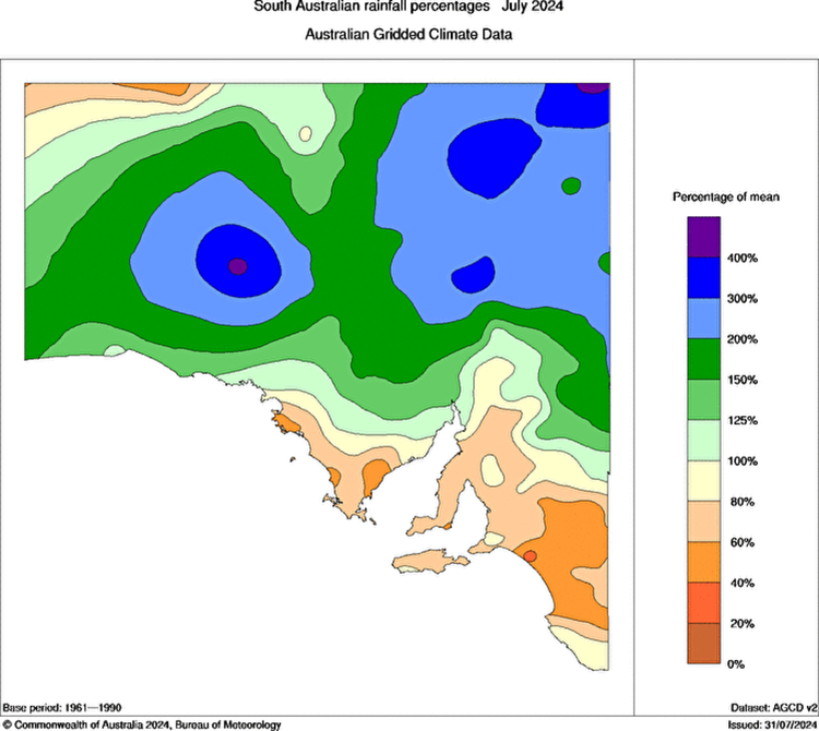
Figure 2: July 2024 rainfall percentages –
source BoM http://www.bom.gov.au/climate/

Figure 3: July 2024 rainfall anomalies –
source BoM http://www.bom.gov.au/climate/
Now as per
usual the revisited July outlook: “Overall, for the month of July, I
originally had this month as a fairly poor month
with increased high pressure. We have already seen that with the current setup
however the amount of moisture feeding in currently is helping set up this
rogue event. I can see average to above average rainfall for the Pastoral
Districts, Flinders as well as much of Eyre Peninsula, with very much above
average pockets across the Southern NW Pastoral and West Coast Districts. As we
move further south however things become a little more complicated. The Upper
North should come closer to average though most areas south of here will be
average to slightly below average. The SE Districts especially will be well
into the below average category I suspect, and this also includes western VIC,
especially the NW corner. Most areas east of the ranges will come in below
average. Overall, not a bad month by any means and I think the really dry edge that looked possible a few months ago
has been taken off thankfully.”
Comparing
this to the charts above in Figures 1-3 we can see that overall, the forecast
in areas performed quite well with the exception of
the Eyre Peninsula which didn’t end up getting to the levels I expected apart
from the northern Eyre Peninsula. The Pastorals as a
whole were above to very much above average. The Upper North also didn’t
quite get to the levels I hoped but wasn’t too much below average. The drier
areas increased generally with southern extent, but especially so for the
Mallee and Upper SE districts. A small pocket heavily influenced by rain shadow
SE of the Mt.Lofty Ranges near the Lakes saw the greatest deficit for the month
with very much below average rainfall.
Looking back
a few months ago, I had July as a troubled month with increased high pressure
and lower rainfall, definitely lower than we saw in
the end. It was a drop back from June but not as low as it could have been. The
greatest problem about this is the increased high pressure (the freak one at
the start of the month aside) trend has not peaked yet and instead much like
the later break in the season, is peaking 3-4 weeks later than the original
outlook from the autumn and indeed even recently. August will suffer as a
result (quite noticeable already for many regions) before we see a response. A
little more on that in the sections below.
Meteorological
Discussion:
Now moving on
to current proceedings and at the time of writing a high-pressure system is
located over Eastern Australia directing a mild NE to N flow across the state.
To the west, a cold front is crossing the Southern WA coastline with a line of
showers and thunderstorms however this is sliding SE through the Bight and
weakening as it runs into the high. An upper trough is interacting with a weak
surface trough off QLD to generate some showers there. Keep a close watch on
QLD in the coming weeks as the coastal strip looks very wet as moisture pours
into a surface trough, with extra spice added aloft with multiple upper
troughs.
The weakening
front crossing from WA will be due on the 8th bringing with it a
broken band of showers, more consistent south of about Gawler but much lighter
further north and indeed east of the ranges will generally more isolated
activity. Unfortunately, I can only see 1-2mm at best for the main farming
areas with many getting less than 1mm. Further south falls may be in the 3-5mm
bracket with some isolated 10mm totals about southern coasts.
Once this
moves through high pressure will return and that has been a theme where
descending air continues to pool over Central to SE Australia with greater
rising air west of WA and again over New Zealand. The intrusions we do get are
short lived and not pronounced which is greatly hurting rainfall totals per
system.
I should note
that frost will make a comeback with this next period of high pressure, not
severe but slight only with the greatest risk occurring around Aug 9-10th
mornings.
Of greater
concern to me is the warmth in the daytime around the western side of the
high-pressure zone, funnelling down as fronts continue their approach but
importantly, do not clean out and replace the warmer air that gets dragged down
with colder air. This will allow much warmer than normal temperatures to
persist for August, more like September conditions. The only good thing about
getting warmth this far south this early is the increased warm and cold
interactions on a synoptic scale that may enhance cut off low development and
this is more likely in the last week of August and more so through September
however I don’t see a strong signal there, just a slight one.
The other
concern is when the fronts start getting stronger again (and they will) with
the wobbling around of the longwave nodes of the negative SAM, the temperature
gradient will enhance and tighten the pressure gradient causing more fresh to possibly strong N-NW winds with those
warm conditions. On top of lower rainfall this will rapidly cure soil and
indeed stress crops that are currently marginal. The early signs of the WA heat
trough across Northern Australia are beginning
which will add to the pre-frontal like structure of the systems with a trough
then a cold front.
Once the
fronts become more established after, we should see an uptick in rainfall to
expected levels, but it will take a significant rogue system to arrest the
deficits we see right now making full use of any weak negative IOD and this is
more likely through September to November but not August. The general speed of
the pattern will be quite fast so a very fluid and mobile pattern of
intermittent fronts. The main uptick should begin in the last third of August
but with such speed comes a greater difficulty in grabbing the moisture
available. This Sudden Stratospheric Warming event (SSW) has not impacted us in
the same way the 2019 one did where the westerly belt expanded and stayed that
way for many months in spring and early summer causing the terrible fire
conditions that we saw. Ideally, we do NOT want that in spring and summer, but
more so in winter or early spring at the latest before the SAM begins to go to
neutral once again. So far this year we have had dreadful positioning of the
longwave trough for 90% of the growing season (and before it). I’ll certainly
be paying extra close attention in the coming 2-3 weeks to see if the expected
uptick does materialise to a level significant enough to impact us.
Thunderstorm
activity should be around the mean through spring and summer, with the usual
peak through November and December. That in its own may frustrate come harvest
time given the hard yards to date. More on the thunderstorm situation though
for the September outlook.
In any case,
I don’t see anything of note before mid-month, a weak sliding front around the
13th followed by another around the 15th before perhaps a
better system around the 18th or so but we will review that in the
next update as I simply do not trust any modelling right now.
Overall,
though, my August outlook is for largely below average rainfall (and note this
is a week later than my normal outlook). I would have expected average a month
or two back with some above average spots but that is likely a bridge too far
unless something enormous finishes the month off- but unlikely. Areas of the
Lower and Upper North, and especially the Riverland and Mallee will see well
below average rainfall. The best chance at least to meet average is across the
southern coastal fringe of the Fleurieu and parts of Kangaroo Island where
frontal activity may skim more frequently but with such a heavy zonal flow,
northern and eastern extent will find it harder to gain good falls.
For the
expected wetter growing season in general though, it simply has not come on as
expected for many reasons, some which I have mentioned but some I need to find
answers for. I do apologise for the poor forecast and that is something I take
seriously.
Climate
Drivers:
The
all-important ENSO has seen a move slightly towards La Nina levels in the past
2 or so weeks but we have a lot of work still to be done. Refer to Figure 4
showing the SST anomalies for more context
There has
been a slight improvement in the cooler waters over the central to eastern
Pacific in the main Nino 3.4 region however a bulk of the cooler water remains
below the surface. I will be specifically looking at October to December for
that to peak. Trade winds remain moderate to occasionally strong and for the
most part, the western Pacific remains warmer than average.
Now the
Indian is doing exactly as I feared with my earlier outlooks – we now have seen
a slight regression in the IOD where cooler water has appeared off Java and
Sumatra. I expected this around July, but it has now appeared in early August,
so about 3 to 4 weeks ‘late’ so to speak. This is a result of the increased
high pressure combined with the cooler surges from the south that we have seen
in recent weeks. The main consequence of this is it will disrupt the convective
signal in that Eastern IOD Box and shift it west for a few weeks before it
pushes back. Most moisture attaching to fronts will get pulled down below the
mainland instead of cutting into it more, but this is not a full blown positive
IOD. The region should warm again to a neutral to weak negative IOD level by
October. The disappointing aspect is we won’t see that sustained negative IOD
type of weather in the two key months of August and September, but a
watered-down version of it in September to October and I understand now that
time is critical for a good rain as mentioned earlier. I wish I had better news
and whilst it won’t be a complete fail for early
spring rainfall, it does look lighter on that it did look earlier this year and
even earlier in winter.

Figure 4:
Current SST anomalies – source Tropical Tidbits
https://www.tropicaltidbits.com/analysis/ocean/cdas-sflux_ssta_global_1.png
The SAM has
dived heavily to negative territory, some of the lowest values we have seen.
You must be wondering well where on earth are the cold fronts and the generally
angry westerly belt after all, a negative SAM causes the fronts and highs to
shift north. Alas after much digging, this index doesn’t just apply to
Australia but all around the South Pole and right now, despite the Sudden
Stratospheric Warming and the resultant heavily negative SAM, the expanded
westerlies have not been consistent but favouring more around areas of the
South Pacific and South Atlantic Ocean. There has been a compensating increase
in ridging right over Australia (seems to never end). Now this will be
temporary, but at least the first 2 to 3 weeks of August will be ridge dominated
with sliding or weaker cold fronts and rain bearing systems. I can see the
wobble of the broader longwave approaching Australia in the final third of
August but last well into September and this will see an increase in cold
fronts and lows but critically, an increase in WIND and WARMTH ahead of these
systems which will no doubt stress crops if the first systems do no bring
enough rainfall.
The MJO has
been largely irrelevant to our weather of late, but it would be nice to see a
stronger pulse move over the Central to Eastern Indian to counteract the
westerly winds in that region at the moment. It
looks weak right now and that weak signal should move into our window later in
the month, slowly stifling out this attempt at increasing cooler water off
Indonesia and thus generally promoting neutral conditions.
Districts:
Eyre
Peninsula
Weakening
cold front crossing on 8th with a broken band of showers, generally
more isolated with northern extent with light falls only. New ridging behind
and becoming established thereafter across the state. Slight frost risk early 9th
and 10th. Winds turning NE to N and freshening from 11th
to 13th as high moves eastwards bringing warmer conditions into the
mid 20’s. Weak sliding front on 13th with isolated showers but
minimal rainfall. Follow up front around 15th with isolated to
scattered showers. Slight risk of a mid-level thunderstorm with this front.
Rainfall for the period 3-5mm with isolated 7-10mm falls in the far southern
portions of Lower Eyre Peninsula. Totals decreasing towards the N and NE with
less than 1-3mm potentially.
Upper North
Weakening
cold front crossing on 8th with a broken band of light showers,
generally more isolated with northern extent with light falls only. New ridging
behind and becoming established thereafter across the state. Slight frost risk
early 9th and more so 10th. Winds turning NE to N and
freshening from 11th to 13th as high moves eastwards
bringing warmer conditions into the mid 20’s, especially closer to Port
Augusta. Weak sliding front on 13th with very isolated showers but
minimal rainfall. Follow up front around 15th with isolated to
possibly scattered showers though most likely in the south. Slight risk of a
mid-level thunderstorm with this front in the north and west. Rainfall for the
period 2-4mm with isolated 4-5mm falls in the far south. Totals decreasing
towards the Flinders and over the east side of the ranges down to 1mm or less.
Lower North
Weakening
cold front crossing on 8th with a broken band of light showers,
generally more isolated with northern extent with light falls only. New ridging
behind and becoming established thereafter across the state. Slight frost risk
early 9th and more so 10th. Winds turning NE to N and
freshening from 11th to 13th as high moves eastwards
bringing warmer conditions into the low to mid 20’s, especially in the far
N/NW. Weak sliding front on 13th with isolated showers but minimal
rainfall. Follow up front around 15th with isolated to scattered
showers though more likely in the south. Slight risk of a mid-level
thunderstorm with this front in the north and west. Rainfall for the period
3-6mm with isolated 6-8mm falls in the far south. Totals decreasing towards the
east side of the ranges down to 1-2mm or less.
Yorke
Peninsula
Weakening
cold front crossing on 8th with a broken band of showers, generally
more isolated with northern extent with light falls only. New ridging behind
and becoming established thereafter across the state. Slight frost risk early 9th
and 10th in the far north chiefly. Winds turning NE to N and
freshening from 11th to 13th as high moves eastwards
bringing warmer conditions into the low to mid 20’s. Weak sliding front on 13th
with isolated showers but minimal rainfall. Follow up front around 15th
with isolated to scattered showers especially so down towards the foot. Slight
risk of a mid-level thunderstorm with this front. Rainfall for the period 3-5mm
with isolated 5-8mm falls about the foot. Totals decreasing towards the N down
to 2-3mm.
Kangaroo
Island
Weakening
cold front crossing on 8th with a broken band of showers. New
ridging behind and becoming established thereafter across the state. Slight
frost risk early 9th and 10th in the centre of the
island. Winds turning NE to N and freshening from 11th to 13th
as high moves eastwards bringing warmer conditions to near 20C Weak sliding
front on 13th with isolated showers. Follow up front around 15th
with scattered showers. Slight risk of a mid-level thunderstorm with this
front. Rainfall for the period 4-8mm with isolated 8-12mm falls. Totals
decreasing towards the E down to 3-4mm.
Adelaide
Plains
Weakening
cold front crossing on 8th with a broken band of showers, generally
more isolated with northern extent with light falls only. New ridging behind
and becoming established thereafter across the state. Slight frost risk early 9th
and 10th about outer northern plains. Winds turning NE to N and
freshening from 11th to 13th as high moves eastwards
bringing warmer conditions into the low to mid 20’s, chiefly about northern
outer plains. Weak sliding front on 13th with isolated showers but
minimal rainfall. Follow up front around 15th with isolated to
scattered showers. Slight risk of a mid-level thunderstorm with this front.
Rainfall for the period 4-7mm with isolated 7-10mm falls about the foothills.
Totals decreasing towards the N down to 3-4mm.
Mt.Lofty
Ranges
Weakening
cold front crossing on 8th with a broken band of showers, more
frequent about the Southern Fleurieu but generally more isolated with northern
extent. New ridging behind and becoming established thereafter across the
state. Slight frost risk early 9th and 10th about
low-lying valleys and the Barossa region. Winds turning NE to N and freshening
from 11th to 13th as high moves eastwards bringing warmer
conditions into the low 20’s, chiefly about northern ranges. Weak sliding front
on 13th with isolated showers but minimal rainfall. Follow up front
around 15th with isolated to scattered showers, chiefly about the
southern coasts and ranges. Slight risk of a mid-level thunderstorm with this
front. Rainfall for the period 5-10mm with isolated 10-20mm falls about the
southern coasts and ranges and known wet spots. Totals decreasing towards the
northern ranges down to 3-5mm.
Riverland/Mallee
Weakening
cold front crossing on 8th with a broken band of light showers,
generally more isolated with northern and eastern extent with light falls only
with rain shadowing not helping. New ridging behind and becoming established
thereafter across the state. Slight frost risk early 9th and more so
10th. Winds turning NE to N and freshening from 11th to
13th as high moves eastwards bringing warmer conditions into the mid
20’s, especially over the Riverland. Weak sliding front on 13th with
very isolated showers about the Mallee only. Follow up front around 15th
with isolated to possibly scattered showers though most likely over the Mallee
once again. Slight risk of a mid-level thunderstorm with this front. Rainfall
for the period 1-3mm with isolated 4mm falls about the southern/SE Mallee.
Totals decreasing towards the Riverland down to 1mm or less.
Upper SE
Weakening
cold front crossing on 8th with a broken band of showers, generally
more isolated with northern and eastern extent with light falls only. New ridging behind and becoming established
thereafter across the state. Slight frost risk early 9th and more so
10th. Winds turning NE to N and freshening from 11th to
13th as high moves eastwards bringing warmer conditions into the low
20’s. Weak sliding front on 13th with isolated showers. Follow up
front around 15th with scattered showers, more likely with southern
extent. Slight risk of a mid-level thunderstorm with this front. Rainfall for
the period 3-5mm with isolated 5-7mm falls about the southern parts and near
the Coorong coastline. Totals decreasing inland and towards the Mallee around
3mm.
Lower SE
Weakening
cold front crossing on 8th with a broken band of showers. New
ridging behind and becoming established thereafter across the state. Slight
frost risk early 9th and more so 10th. Winds turning NE
to N and freshening from 11th to 13th as high moves
eastwards bringing warmer conditions into the low 20’s. Weak sliding front on
13th with isolated showers. Follow up front around 15th
with another general band of showers, with better falls in the far southern
coastal strip. Slight risk of a mid-level thunderstorm with this front.
Rainfall for the period 5-10mm with isolated 10-15mm falls about the southern
coastal strip. Totals decreasing inland and towards the Upper SE down to 4-5mm.
Western VIC
Weakening
cold front crossing on 8th with a broken band of showers, generally
more isolated with northern extent towards both the Wimmera and especially
Mallee Districts with light falls only.
New ridging behind and becoming established thereafter across the state.
Slight frost risk early 9th and more so 10th. Winds
turning NE to N and freshening from 11th to 13th as high
moves eastwards bringing warmer conditions into the low 20’s. Weak sliding
front on 13th with isolated showers about the SW District only with
minimal rainfall north of here. Follow up front around 15th with
scattered showers, more likely with southern extent again. Slight risk of a
mid-level thunderstorm with this front. Rainfall for the period 4-6mm with
isolated 6-10mm falls about the SW District. Totals decreasing with northern
extent generally down to 2-4mm, more likely about the Mallee.
Final Notes
·
General growing season seeing a lack of
significant systems in our window but especially impactful east of the ranges
with heavy rain shadow
·
Dominant zonal flow when fronts do come in
still hurting both eastern and northern areas the most
·
Small uptick later August but not enough to
salvage average rainfall
·
Warmth and winds picking up ahead of a more
mobile and active spring frontal pattern in September with fast moving fronts
·
At best now expecting an average spring
rainfall, a comeback from what we have now but not significant enough to erase
deficits
·
Moisture invading with warmth as spring goes
by, increasing thunderstorm risk for November and December but only to expected
levels
·
SSW impacts generally causing mayhem with
westerly belt and not in Australia’s favour currently but more for the Southern
Atlantic.
Link to
temporary blog website: https://farmweathersa.blogspot.com/
Happy Farming
and Cheers from The Weatherman
*Note –
For interest only, all thoughts are of The Weatherman and may not be reproduced
without my consent.


Comments
Post a Comment