July Outlook 2024 SA
July outlook 2024 SA
*Forecast
prepared between July 1st-4th 2024
Review:
G’Day once
again everyone, July is upon us and although time seems to be vanish these days, I’ll whip out a quick outlook on
what to expect.
Firstly
though, we’ll have a look back at June and how that panned out, the main
talking point is we got a break in the season for most of you however, some
would definitely feel like the rain is avoiding
them, and these areas are primarily over the Upper North.
After a dry
start, the fronts and NW cloudbands started to come in and increase in
frequency. The break for most of the agricultural areas was made up of lots of
small amounts of light to occasionally moderate rainfall rather than one big
solid breaking event. We did however finish the month strongly with two great
systems, the first with a lot of colder air and solid convective showery bands
through the 24th-26th period and then the NW Cloudband to
finish the month with a good soaking rainband for many southern agricultural
areas – with a big focus over the Mt.Lofty Ranges and areas south of Adelaide
over the Fleurieu Peninsula. This supply of moisture was expected from the
Indian as the jetstream became squeezed.
Here are the
rainfall charts below and to be honest, it wasn’t that bad at all for some
districts but there were some noteable misses:

Figure 1: June 2024 rainfall deciles – source
BoM http://www.bom.gov.au/climate/

Figure 2: June 2024 rainfall percentages –
source BoM http://www.bom.gov.au/climate/

Figure 3: June 2024 rainfall anomalies –
source BoM http://www.bom.gov.au/climate/
Here is the
June outlook that was issued:
“Now as far
as the rest of the month goes as a whole, my
official outlook is for very close to average rainfall for areas west of the
ranges but slightly on the lower side of average. The West Coast and Eyre
Peninsula have the greatest chance of getting above average rainfall as well as
parts of the NW Pastoral District. Whilst I see a good increase in fronts and
rainfall this month, the fractured nature of the break combined with the fact
that June is usually the wettest month of the year means that we will be
working quite hard to exceed averages everywhere. The greatest chance of below
average rain will be immediately east of the ranges, across the Upper North and
generally the SE Districts and Kangaroo Island. The latter whilst getting more
rain than most districts, normally gets battered by winter fronts and has quite
a high average rainfall for June. Having said that, it shouldn’t be too much
below. Most other areas should be closer to their average but slightly below.
So, in short, yes a much better month but we expect
this and despite the improvement, I still see things falling just short for the
majority.”
Looking at
the charts compared to that outlook, I think the worst and best areas were
relatively well nailed with the much drier Lower SE
and Upper North as well as the wetter Eyre Peninsula to West Coast though the
Far West Coast areas up to Streaky Bay at least did come up short. The wetter
Pastoral area was generally more over the western parts of the NE Pastoral than
the NW. Kangaroo Island ended up doing really well
in the end with a big finish getting just above average. The Mt.Lofty Ranges
did well with just above average. The Lower North started very poorly but came
home well however still fell below average. East of the ranges showed fairly close to average with some slightly above
average areas through the Mallee and Riverland which was pleasing. It was a
varied month to say the least.
Finally, I
thought I’d share the May pressure anomalies that have finally come out from
NOAA. It is no surprise to see the monster high pressure and so far south. Yet
somehow the SAM forecast went heavily negative. Mind boggling.
 |
Figure 4 –
May 2024 500hPa presure anomalies showing high pressure south of Australia –
source NOAA https://www.ncei.noaa.gov/access/monitoring/monthly-report/global/202405
With these
sorts of anomaly charts, it is fairly easy to see
why we were so dry with a lack of fronts to start our season off.
Meteorological
Discussion:
So on to
current proceedings and we certainly have a unique pattern to start July off. I
wish I had the time to update on this earlier with the phenomenal massive
high-pressure area south of mainland Australia. We have just set a new
Australian pressure record at Sheffield in Tasmania of 1044.4hPa. Under the
same massive high-pressure system, Liawenee in the Central Highlands has set
consecutive July records for the site with –12.9C and then this morning –13.5C
which is incredibly cold. Images of extreme frost covering everything from the
ground to the tops of trees have been circulating around the ether. The big
subsidence of very cold and dry air from aloft under such a high pressure has
made this possible.
But back to
SA and currently we are also under the influence of that massive high with a
second slightly weaker but still strong high to move in and join up with the
first in the coming days. This will result in a fresh E-NE airstream across the
state for many days in succession which is very rare for July and even Gully
winds are expected. In between the two highs however a weakening trough is
pinching off from the westerly belt and lifting north. A broad upper low aloft
will sit above this trough, cradled by the high and upper ridge to the south.
The resultant NE flow between the two systems is bringing back from moisture
into SA from QLD (which was at the tail end of the last NW Cloudband).
Some isolated
to scattered mid-level showers west of about the Yorke Peninsula are the
current proceedings from this developing system. Over the coming few days with
the persistent NE flow and the upper low to the west, we will see more moisture
channel into the eastern side of the upper low in a convergent zone. This will
generally be aimed across the Pastoral Zones into the northern parts of Eyre
Peninsula and into the West and eastern parts of the Far West Coast at first.
The showers and cloud will thicken up till Saturday the 6th where
upon some of this will begin to amalgamate into a band of rain, still feeding
SW.
Gully winds
and a general fresh to even occasionally strong E to NE flow with the potential
for near damaging gusts may occur over the peaks and down the western slopes of
the Flinders Ranges specifically but potentially to the Northern Mt.Lofty
Ranges. The most likely date for this the evening of the 5th and
early 6th but possibly again into the 7th.
Rain areas
will weaken as they move SW/S with a lot of the activity struggling to make it
south of Gawler and certainly Adelaide. The bulk of the activity should
primarily focus north of about Renmark to Port Augusta to Ceduna for a rough
line. However, whilst some locations that have struggled this year may get very
good falls, there remains a small strip across the southern parts of the Upper
North and maybe some of the northern parts of the Lower North that will still
be a little short. The Northern Eyre Peninsula, Flinders (especially north of
Port Augusta), much of the NE Pastoral, The West Coast, Eastern parts of the
Far West Coast including adjacent inland and S/SW parts of the NW Pastoral
District should do quite well with welcome rainfall.
This system
will weaken as it sinks SE with the rain areas reaching the Adelaide area and
Riverland and northern parts of the Mallee but at a reduced rate with very
light falls only.
A weakening
cold front or shortwave trough will then connect to the remnants of the system
on the 8th and into the 9th and briefly re-invigorate
showers and light rain areas across the SE Districts chiefly but also into the
Mallee a little bit. Coastal locations west and south of about Adelaide should
see some cooler air and isolated to scattered showers in a weak, but moist
onshore airstream.
After this a
weak high will attempt to establish across the NE portions of the state and
over NSW ahead of a much stronger cold front and possible NW Cloudband at a
flattish angle, which will be part of the Longwave Trough moving east before it
sadly dissolves and sinks back down to the Antarctic. A new Longwave trough
will re-establish afterwards back where it has been sitting for months now,
just SW/W of WA.
Now this
stronger system is most likely due somewhere around the 11th with
the rainband potential. Given the longwave trough will be located below WA and
the Bight, we should see the subtropical jetstream remain strong across the top
of it so it wouldn’t surprise me to see a semi-permanent cloudband marking this
across the interior somewhere coming out of the Indian. The specifics of this
however are yet to be nailed however a general area of rain, followed by colder
air and showers is possible, with a westerly flow for a few days after. Given
that I expect the longwave to sag, a deeper SW-S flow behind it does not seem
likely at this stage.
A new high is
likely behind this as we still will look to enhance high pressure over the
mainland with colder air aloft. This in turn might enhance ECL potential off
the NSW coast.
The main
frost risk for this period will be on the 10th as the new high
albeit weak attempts to establish with generally light winds. It will not
however be to the levels we have seen over the last
few mornings where we had multiple rounds of negative temperatures and
widespread moderate frost across the state, even in coastal areas. There is
also potential around the 14-15th although a low risk at this stage.
Overall, for
the month of July, I originally had this month as a fairly
poor month with increased high pressure. We have already seen that with the
current setup however the amount of moisture feeding in currently is helping
set up this rogue event. I can see average to above average rainfall for the
Pastoral Districts, Flinders as well as much of Eyre Peninsula, with very much
above average pockets across the Southern NW Pastoral and West Coast Districts.
As we move further south however things become a little more complicated. The
Upper North should come closer to average though most areas south of here will
be average to slightly below average. The SE Districts especially will be well
into the below average category I suspect, and this also includes western VIC,
especially the NW corner. Most areas east of the ranges will come in below
average. Overall, not a bad month by any means and I think the really dry edge that looked possible a few months ago
has been taken off thankfully.
Climate
Drivers:
The Pacific
is ever so slowly creeping towards a weak La Nina but for the meantime it
remains smack bang on neutral with no significant influence either way, we are
still very much in formation stages of the weak La
Nina.
Please refer
to Figure 5 below to see a sequence of the Pacific sub-surface anomalies. Here
we can see the change since March and the main take home point is that whilst
the cooler/colder anomalies are rising to the surface in typical La Nina
fashion, they are thinning out. I do expect some comeback however once we see
trade winds improve towards spring but I only
expect a modest improvement.

Figure 5: Pacific Ocean
sub-surface time series from March-June 2024 – source BoM http://www.bom.gov.au/climate/enso/wrap-up/archive/20240625.sub_surface_anom.png?popup
Now moving on
to the Indian and we have seen some rather interesting developments in the
progress of the IOD. Refer to Figure 6 below showing the usual SST anomalies:
Figure
6: Current SST anomalies – source Tropical Tidbits https://www.tropicaltidbits.com/analysis/ocean/cdas-sflux_ssta_global_1.png
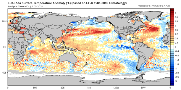
The main focus for
discussion is the cooling area north of Madagascar which is partially in the
Western IOD Box and the warming areas off Sumatra and Java which is essentially
all of the Eastern IOX Box. This has contributed to
the latest IOD reading being –0.4C which is the
cutoff for a negative IOD. I maintained since last year this year is most
likely to be a negative event as opposed to a positive one and that we would
have a ‘false positive’ when in May, much discussion and noise was coming out
about a looming Positive IOD which I felt was nonsense at the time. We still
have a long way to go of course but I expect modelling to slowly respond to the
changes we are seeing. The extreme persistence of the longwave trough off WA
has caused winds to slacken off Sumatra preventing cold water upwelling and
allowing warmer water to pool whilst some moderate MJO action. I expected a bit
of a fight back in the values at least with more high pressure in July and
currently we are seeing some of this right now, however the highs are VERY far
south rather than centred over the mainland which will lessen that impact. To
me as long as the Longwave Trough remains generally
anchored off WA, we will favour that weak Negative IOD or at least a neutral to
negative where we sit in the 0 to –0.4C range through Spring.
The SAM is the next interesting topic and has
been struggling to go negative for a while, with some weak bursts but mostly
neutral to positive and certainly right now, is making a huge positive spike,
one of the biggest in many years with record high pressure being recorded over
Tasmania with 1044-1045hPa. We have a double up of two highs merging into one
and extending strong easterlies across the mainland and for some distance below
the mainland as well and this will enhance positive values and is very much the
opposite of what we normally expect in July. I expect as mentioned before the
Longwave Trough to finally shift east but also weaken as it does so before
re-emerging/forming back up west of WA. This area is very favourable right now
to keep the bulk of it anchored there. The SAM should dip back to neutral to
possibly weak negative values just before mid-month before going more positive
again as we push into the second half of the month.
The MJO is
very much weak at the moment with no major influences. There may be just enough
life in it to keep the Positive IOD at bay with some westerlies across the
Indian and also enhance cooler water to generally stay off the horn of Africa.
Trade winds over the Pacific will wash it out there.
Districts:
NW/NE
Pastoral
Upper low
combining with moisture feed from QLD generating scattered showers and isolated
thunderstorms across western parts of the NE pastoral and Eastern to southern
parts of the NW Pastoral. Activity increasing to areas of rain and isolated
thunderstorms from the 6th and extending further SE to cover most of
the remainder of the NE Pastoral and parts of the Flinders. Localised heavy
falls possible, chiefly over the Flinders and also
the Southern parts of the NW Pastoral where convergence training may be more
long-lived. Rain areas clearing largely by the 8th as the upper low
weakens and sags SE. A new high forming over the region there
after and largely persisting for the next 4-6days. Possible renewed
cloudband across the interior in the 11th-15th period as
longwave trough moves below the state. Slight to moderate frost risk, chiefly
in the south of the NE Pastoral on the 10th. Rainfall for the period
general 15-30mm with scattered 30-50mm falls. Isolated localised totals to
60-80mm possible about the northern Flinders and southern NW Pastoral. Minimal
rainfall expected over the western third of the NW Pastoral, generally less
than 1-2mm to nil in the very far NW corner.
Eyre
Peninsula
Upper low
combining with moisture feed from QLD generating scattered showers and isolated
thunderstorms across western and northern parts of the district from the 5th.
Activity increasing to areas of rain and possible isolated thunderstorms
(chiefly far western and northern portions) from the 6th and
extending further SE to cover most of the remainder of the Peninsula. Localised
heavy falls possible, chiefly over the far northern and western portions of the
Peninsula into the West Coast District and adjacent inland where convergence
training may be a little more long-lived. Rain areas clearing largely by later on the 7th as the upper low weakens
and sags SE. Weak front with isolated showers chiefly about Lower Eyre
Peninsula on 8th. A new high forming over the NE of the state
clearing activity and a slight risk of frost for the 10th.
Freshening N/NW winds on 10th ahead of stronger front late on 10th
into 11th with areas of rain tending to showers
behind with colder air. Activity much more isolated with northern extent in
wake of front. A follow up weak front or two with isolated showers about the
southern and western half of the Peninsula in the onshore westerly flow till
mid-month before clearing as a new large high moves
in from the west. Rainfall for the period general 15-25mm with scattered
25-30mm falls. Isolated localised totals to 30-40mm possible about the far
northern and western portions of the Peninsula bordering the NW Pastoral and
out to the West Coast.
Upper North
Upper low
combining with moisture feed from QLD generating areas of areas of patchy rain
in the far north on 6th. Activity slowly extending southwards and increasing into the on 7th and
extending further SE/S to cover most of the remainder of the district however
the good rainfall will be confined chiefly to the northern half only. Localised
heavy falls possible about the Southern Flinders north of Port Augusta. Strong
and gusty downslopes/gully winds on evening of 5th and possibly 6tR
with winds potentially damaging at times. Rain areas clearing largely by later on the 7th as the upper low weakens
and sags SE however drizzle periods about the ranges are likely to persist in
moist conditions with low cloud lingering through till the 8th. Weak front with
isolated showers chiefly in the south during the afternoon of the 8th.
A new high forming over the NE of the state clearing activity and a slight to
moderate risk of frost for the 10th. Freshening N/NW winds on 10th
ahead of stronger front on 11th with patchy rain tending to scattered showers behind
with colder air. Activity much more isolated with northern extent in wake of
front. A follow up weak front or two with isolated showers about the southern
portions and exposed slopes of elevated terrain facing west in the onshore
westerly flow till mid-month before clearing as a new
large high moves in from the west. Rainfall for the period general 10-20mm
with scattered 25mm falls. Isolated localised totals to 30-40mm possible about
the Flinders and some locations N/NE of Port Augusta. Localised lower holes
persisting SE of Port Augusta down to around 7-10mm.
Lower North
Upper low
combining with moisture feed from QLD generating areas of patchy light rain in
the far north very late on 6th or early 7th. Activity slowly
extending southwards on 7th however any good rainfall will be confined to the
far northern portions only. Strong and
gusty downslopes/gully winds on evening of 5th and possibly 6tR with
winds potentially damaging at times. Rain areas clearing largely by later on the 7th as the upper low weakens and sags SE
however drizzle periods about the ranges are likely to persist in moist
conditions with low cloud lingering through till the 8th. Weak front with
isolated showers to cross during the afternoon of the 8th. A new high forming
over the NE of the state clearing activity and a slight to moderate risk of
frost for the 10th. Freshening N/NW winds on 10th ahead of stronger front on
11th with patchy rain tending to scattered showers
behind with colder air. Activity much more isolated with northern extent in
wake of front. A follow up weak front or two with isolated to scattered
showers, chiefly about exposed slopes of elevated terrain facing west in the
onshore westerly flow till mid-month before clearing as a new large high moves in from the west. Rainfall for
the period general 12-22mm with scattered 25mm falls. Isolated localised totals
to 30-35mm possible about higher terrain and exposed slopes. Localised lower
holes persisting however, most likely towards the E down to around 8-10mm. Less
rainfall is expected from the first event but more from the subsequent systems
compared to the Upper North.
Yorke
Peninsula
Upper low
combining with moisture feed from QLD generating areas of patchy light rain in
the far north very late on 6th or early 7th. Activity slowly
extending southwards on 7th however most rainfall will be confined to the
northern portions only. Light rain areas clearing largely by later on the 7th as the upper low weakens and sags SE.
Weak front with isolated showers to cross during the morning and early
afternoon of the 8th and clearing early 9th. A new high
forming over the NE of the state clearing activity and a slight to moderate
risk of frost for the 10th in the north Freshening N/NW winds on
10th ahead of stronger front late on 10th into the 11th with areas
of rain tending to scattered showers behind with
colder air especially about the foot. Activity more isolated with northern
extent in wake of front. A follow up weak to moderate front or two with
isolated to scattered showers in the onshore westerly flow till mid-month
before clearing as a new large high moves in from
the west. Rainfall for the period general 10-20mm with scattered 25mm falls.
Isolated localised totals to 30mm possible in the far north and also possibly about the foot.
Kangaroo
Island
Upper low
combining with moisture feed from QLD however only very patchy light rain if
any at all is expected to reach the island with conditions remaining cool to
cold and overcast. Weak front with isolated to scattered showers to cross
during the morning and early afternoon of the 8th with a second
weaker trough and colder air to bring renewed evening showers and into the
early parts of the 9th. A new
high forming over the NE of the state clearing activity and a slight risk of
frost for the 10th in the centre of the island. Freshening N/NW
winds on 10th ahead of stronger front late on 10th into the 11th
with areas of rain tending to scattered showers and
possible small hail behind with colder air. Multiple follow up cold fronts with
scattered showers in the onshore westerly flow till mid-month before clearing
as a new large high moves in from the west.
Rainfall for the period general 20-30mm with scattered 35mm falls. Isolated
localised totals to 40mm possible about the western end decreasing to 15-20mm
about the eastern end.
Adelaide
Plains
Upper low
combining with moisture feed from QLD generating areas of patchy light rain in
the far northern plains very late on 6th or early 7th. Activity
slowly extending southwards on 7th however most rainfall will be confined to
the northern suburbs and plains. Light rain areas clearing largely by later on the 7th as the upper low weakens and sags SE.
Weak front with isolated showers to cross during the morning and early
afternoon of the 8th and clearing early 9th. A new high
forming over the NE of the state clearing activity and a slight risk of frost
for the 10th chiefly about northern suburbs and outer plains.
Freshening N/NW winds on 10th ahead of stronger front on 11th with areas of
rain tending to scattered showers behind with
colder air. Activity more isolated with northern extent in wake of front. A
follow up weak to moderate front or two with isolated to scattered showers in
the onshore westerly flow till mid-month before clearing as a new large high moves in from the west. Rainfall for
the period general 15-25mm with scattered 30mm falls. Isolated localised totals
to 40-45mm possible about the foothills and adjacent southern suburbs.
Mt.Lofty
Ranges
Upper low
combining with moisture feed from QLD generating areas of patchy light rain in
the far northern ranges very late on 6th or early 7th. Activity
slowly extending southwards on 7th however most rainfall will be confined to
the northern ranges. Light rain areas clearing largely by later on the 7th as
the upper low weakens and sags SE. Weak front with isolated to showers to cross
during the morning and early afternoon of the 8th and clearing early
9th. Showers more frequent on western slopes and may tend to drizzle
periods or light rain at times. A new high forming over the NE of the state
clearing activity and a slight risk of frost for the 10th chiefly
about low lying valleys and the Barossa. Freshening N/NW winds on 10th ahead of
stronger front on 11th with areas of rain tending to scattered
showers behind with colder air with possible small hail over the southern
coasts and ranges. Activity more isolated with northern extent in wake of
front. A follow up weak to moderate front or two with isolated to scattered
showers in the onshore westerly flow with orographics playing a big part in
rainfall totals till mid-month before clearing as a new
large high moves in from the west. Rainfall for the period general 25-50mm
with scattered 60mm falls. Isolated localised totals to 75mm possible about
known wet spots and higher peaks.
Riverland/Mallee
Upper low
combining with moisture feed from QLD generating areas of areas of patchy light
rain over the Riverland and Northern Mallee on the 7th. Activity slowly
extending southwards and SE on 7th however the rain areas will thin
out as they do so and dissolve. Rain areas clearing largely by later on the 7th as the upper low weakens
and sags SE however drizzle periods at times are likely to persist in moist
conditions with low cloud lingering through till the 8th. Weak front with
isolated showers chiefly over the southern Mallee during the afternoon of the 8th.
A new high forming over the NE of the state clearing activity and a slight risk
of frost for the 10th. Freshening N/NW winds on 10th
ahead of stronger front on 11th with patchy rain tending to scattered showers behind with colder air. Activity
much more isolated with northern extent in wake of front. A follow up weak
front or two with isolated showers about the southern parts of the Riverland
and moreso the Mallee in the onshore westerly flow till mid-month before
clearing as a new large high moves in from the
west. Rainfall for the period general 8-15mm with scattered 20mm falls.
Isolated localised totals to 25-30mm possible over the far SE of the Mallee.
Totals decreasing to 5-8mm with some holes over the central and northern Mallee
and Riverland.
Upper SE
Upper low
combining with moisture feed from QLD however barely any rainfall is expected
apart from some patchy light rain in the far north. Weak front with isolated
showers possibly tending to drizzle areas at times during the afternoon and
evening of the 8th before clearing on the 9th. A new high
forming over the NE of the state clearing activity and a slight risk of frost
for the 10th. Freshening N/NW winds on 10th ahead of
stronger front later on 10th till early
on 11th with areas of rain tending to scattered
showers behind with colder air with possible small hail about the Coorong
coastline and adjacent inland. A follow up weak to moderate front or two with
isolated to scattered showers in the onshore westerly flow till mid-month
before clearing as a new large high moves in from
the west. Rainfall for the period general 10-20mm with scattered 25mm falls.
Isolated localised totals to 25-35mm possible over the far SW of the district
near the Coorong coastline.
Lower SE
Upper low
combining with moisture feed from QLD however barely any rainfall is expected.
Weak front with isolated to scattered showers possibly tending to drizzle areas
at times during the afternoon and evening of the 8th before clearing
during the morning on the 9th. A new high forming over the NE of the
state clearing activity and a slight risk of frost for the 10th.
Freshening N/NW winds on 10th ahead of stronger front later on 10th till early on 11th
with areas of rain tending to scattered showers
behind with colder air with possible small hail and
isolated cold air thunderstorms, chiefly in the west and south. A follow up
weak to moderate front or two with isolated to scattered showers in frontal
bands and colder air in the onshore westerly flow till mid-month before
clearing as a new large high moves in from the
west. Rainfall for the period general 30-40mm with scattered 45mm falls.
Isolated localised totals to 50mm possible over the far SW of the district
closer to the coast.
Western VIC
Upper low
combining with moisture feed from QLD however barely any rainfall is expected
at first apart from some patchy rain about the northern Mallee. Lingering
moisture from the system on 8th will generate areas of light showers
thickening to drizzle periods. Weak front lifting areas of drizzle to light
rain areas on 9th chiefly about the Grampians before clearing later.
A new high forming over the NW of the state and NE SA clearing activity and a
slight risk of frost for the 10th. Freshening N/NW winds on 10th
ahead of stronger front on 11th with areas of rain tending to scattered showers behind with colder air with possible
small hail and isolated cold air thunderstorms about the SW District. A follow
up weak to moderate front or two with isolated to scattered showers in frontal
bands and colder air in the onshore westerly flow, chiefly for the SW District
with lesser impacts for the Wimmera and especially Mallee till mid-month before
clearing as a new large high moves in from the
west. Rainfall for the period general 25-35mm about the SW District, 10-20mm
Wimmera and 8-15mm Mallee. Scattered 25-30mm falls about the Grampians and
adjacent locations. Localised heavier falls about the southern coast of the SW
District to 40-45mm. Lighter holes likely about the Mallee down to 5mm, chiefly
the far NE.
Final Notes
·
Dominant and unusually far south
high-pressure system bringing moisture into state from QLD combining with upper
low over the interior of SA to generate areas of rain with local heavy falls in
the north and Central West.
·
Dry spells still, likely through mid to later
July however persistent moisture still feeding from the NW helping mitigate
some of this
·
Enhanced frost risk still
remains for July
·
Weak negative IOD forming despite hype of a
Positive IOD from countless sources
·
La Nina formation slow and will only be weak
but combined influence will see rainfall tend to increase through spring,
chiefly mid to late spring and early summer
Link to
temporary blog website: https://farmweathersa.blogspot.com/
Happy Farming
and Cheers from The Weatherman
*Note –
For interest only, all thoughts are of The Weatherman and may not be reproduced
without my consent.


Comments
Post a Comment