March outlook 2024 SA
March outlook 2024 SA
*Forecast prepared between March 8-10th 2024
Review:
G’Day everyone, I trust you are all keeping well. Firstly, my most sincere apologies for the lateness of the March outlook, there has been quite a bit going on within the family and that at this time must come first. But in these spart moments I do have, I’ll whip up something all the same. Back on track for mid-month hopefully!
Now taking a look back to February and honestly there is much to talk about rain wsie (I’ll get to the March storms up north and out west in a little bit). A big fat 0.0mm at my place and I am sure just about the entire agricultural area received similar, perhaps a few stations recorded a trace with some mid-level showers only. The main rainfall impacts were earlier in the month over the NE Pastoral District, and primarily in the NE corner, with Moomba doing very well recording 106.2mm for the month. It is likely some area north of here recorded upwards of 150mm for the month which was no doubt extremely welcome being one of the drier parts of the state up until this time.
Now let's take a look at the final rainfall maps for February below:
 |
| Figure 1: February rainfall deciles - source BoM http://www.bom.gov.au/climate/ |
 |
| Figure 2: February rainfall percentages - source BoM http://www.bom.gov.au/climate/ |
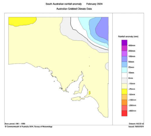 |
| Figure 3: February rainfall anomalies - source BoM http://www.bom.gov.au/climate/ |
As we can see here from Figures 1-3, it was a dry month over much of the state except for the NE corner. The simple reason was for a reset in the monsoon, MJO and SAM all combining to reduce the moisture feeding into the state and the triggers needed to lift it. Subsidence prevailed, especially once that early month heavy rain cleared from the NE, that area too was dry for the remainder of the month.
Now a quick look back at the February outlook: ‘As far as the rainfall outlook is concerned, I am still expecting a drier month overall as we are in reset mode. The exception of course will be the NE corner of the NE Pastoral which will blow right out to above to very much above average from this rainfall event in the coming 24-48hrs. This also is likely to be the first-place recycled moisture pushes back into from the E/NE with spasmodic isolated afternoon thunderstorm activity. Some potential rainfall is likely at the very end of the month or into March, but it is a little tricky to pinpoint. If it is March, then some locations will see no rain for the entire month, but I think something may come just in time. However, despite this, I’m still expecting broadly below average with some very much below average areas in Central/Southern areas tending to average across the very far west of the state.”
Overall, a good month but honestly it was a fairly strong dry signal with a relatively easy prediction level so nothing amazing forecast wise in the end.
The main take home so far from the first few days of March is the intense burst of thunderstorms we had from a squeezed jetstream ripping beneath the ever-intensifying upper ridge, whilst utilising moisture that was feeding into WA. Some truly tremendous rainfalls have occurred with flash flooding over the West Coast, cutting the Eyre Highway with water as far as the eye can see in some locations near Penong and out near Nundroo with reported falls of 120-150mm, most in a short space of time, a mere 2-3hours. Thunderstorms fired along this convergence zone right across the top of Eyre Peninsula into the Upper North/Flinders District with numerous heavy totals recorded, especially near Hawker though not to the level of the West Coast. These storms became more isolated to the south and the gradient was quite sharp to clear and sunny weather below with the ridge to the south holding it all north.
Meteorological Discussion:
Looking at the current charts and so far this month we have been under the influence of a deep upper ridge bringing a lot of the heat WA has been experiencing so far this summer. Essentially all that has happened is that there has been a shift to the east of this broadscale pattern. Some thunderstorms and heavy falls did occur with a big jetstream squeeze early in the month over the Flinders and West Coast/Far West Coast but despite some extreme falls, much of SE Australia has been pretty dry as the upper ridge plants itself. We normally see this in February and for the most part, a lot of this did start in February with reset from the wetter December and January. WA after being so, so dry has now become wetter as the warming SST’s occur to the north of the mainland and off Indonesia, feeding that moisture into a parched landscape. This big open channel to the tropics is essentially an atmospheric river of mass convergence held in place by the ever-persistent upper ridge to the east, focusing the rain and thunderstorms over WA (especially the Goldfields and interior areas) whilst keeping the rest of us dry.
This event over WA is going to be quite incredible, especially over the Southern Interior, Eastern half of the Goldfields and Western parts of the Eucla – and has already begun as I type with 100-150mm totals in parts of the Eucla District. With a further 200-300mm to come for some of these regions, I am expecting many roads to be completely cut (including the Eyre Hwy) and communities isolated by widespread flooding caused by relentless convergence with showers, areas of heavy rain and isolated thunderstorms. Areas further west in WA will see much less thanks to some ridging holding the moisture inland though the long-awaited wet season for very dry places such as Broome will finally come as the MJO combines with the warmer SST’s which sees uplift maximised. Good tropical rainfall with heavy falls and flooding will occur across a bulk of N WA and also the NT once again with both states likely to see some strong monsoonal lows with a good potential for one or two Tropical Cyclones to category 2 or 3 strength at this stage. The pattern is not quite conducive to seeing strong Tropical Cyclones yet.
Back to SA. And the heat will continue with 37-42C temperatures locked in under this upper ridge for one more day on the 11th before the upper ridge lifts north allowing a cooler change to push in with a new strong surface ridge pushing a low level surface trough (the one that will be delivering the heavy rain for WA) through though still remaining hot over the western ag, northern ag and inland areas but the southern agricultural areas will see temperatures reduce into the low 30’s. From around the 13th we will see those upper level gradients tighten as a weak upper trough wanders up NE from the deep south and this should enhance the surface trough to begin to deepen once more over the state drawing in some moisture but I am not expecting significant amounts – most of it will be a fragmented band of moisture pulled in from the leftovers of the heavy WA rain event. The result will be some isolated mid-level showers and perhaps some thunderstorms as well given the lift tending to a thin band or small bands of patchy rain at times, which will invade chiefly below KI and into the Lower SE from the 13th.
As we pass the mid-month the moisture from WA will linger in a surface trough over SA with potential for some isolated showers and thunderstorms with ridging cradling it from below before a stronger upper trough pushes in from the SW around the 18th bringing some shower activity but also clearing some of that heat and moisture further inland.
I won’t give an official March outlook this time given how late we are, but the expectation is for wetter in the west and drier in the east. Originally it appeared we would resume to wetter conditions from the first week and things started well but the persistent upper ridging has held out the huge tropical intrusion and kept it over WA delaying our impacts by a good 2-3 weeks.
Overall, we still look good going forward, with that moisture building to the NW. I expect the usual mid-autumn lull, likely after this tropical rinse finalises before the fronts start to stand up, especially in May.
Climate Drivers:
The Pacific has revealed for the first time an area of much colder than average water in the far east and this is the upwelling of that colder sub-surface water. Essentially this is the beginning of La Nina at the surface but as we know the atmosphere is already well ahead of the oceanic state when it comes to La Nina for 2024. Once the ocean catches up, we will certainly see a significant coupling but that is still months away. Figure 4 below shows this colder water quite clearly. As per my previous discussions, nothing has changed as warmer water piles up on the Australian side and across the Top End. This is just the beginning of the overall wetter pattern despite the current drier conditions and upper ridging.
 |
| Figure 4: Current SST anomalies – source Tropical Tidbits |
Moving onto the Indian and continued progress has been made with the warming off the NW Coast and south of Java ahead of the next MJO pulse and it is no surprise whatsoever now that we have the largest area of convection here for the entire Inter Tropical Convergence Zone (ITCZ). This is greatly increasing up motion in the region before feeding it south into WA and causing the phenomenal rainfall that has just started falling and as mentioned before, will continue over the coming 5 days or so with relentless convergence. Overall, the patterns bode well for a negative IOD and greater than normal moisture located off the NW shelf of the country as we move into the growing season, especially once the longwaves start to rise from the south to meet it which highlights May and June especially so.
The MJO has been moving back into our window for a couple of weeks now and that can clearly be seen on the satellite imagery as per the ITCZ discussion in the previous driver above. We are entering phase 4 now with a moderate strength signal, but overall, quite slow moving which should at least keep the uplift well and truly in our window/zone for the remainder of the month before a slow transition to phase 7 and 8 by April. The signal strength will be moderate with possibly even some strong strength by phase 6 which will something to look out for and certainly gives a good chance of increased tropical cyclone activity off both sides of the continent as per the discussion in the previous update – this should be a relatively active cyclonic period but with a bias towards WA and again over the South Central Pacific when the MJO is further east. This all sets up to provide us with a maximised amount of moisture to enhance heavy rainfall, especially inland and already we have seen that over WA which should be the main focus, but that focus will shift east as the month wears on.
The SAM has been largely un-interesting of late hanging around neutral territory for much of the last 2 weeks. There is a slightly positive bias but that will turn to a slight negative bias in the coming weeks as the upper ridge that has been causing all of our heat will lift back north allowing a couple of strong shortwaves to waffle below the mainland, throwing up some swell at least and also easing the heat. They will also squeeze the jetstream so we may see some mid-level cloudbands shoot east from that WA moisture to bring some patchy rain, but chiefly quite a long way south in the state. The signal is weakish atm though with the upper ridging dominant. Moving forward, we will see more positive than negative SAM in the coming months allowing moisture to be feeding back in from the NW and N.
Districts:
Eyre Peninsula
Hot to very hot at first on 11th and 12th ahead of a weak trough bringing a cooler coastal change. New ridge establishing behind however quickly sliding beneath the district. Tight gradient aloft combined with approaching weak upper trough and deepening surface trough cradled in ridge on 14th will generate some isolated showers and thunderstorms through till 15th or 16th. Shower activity may tend to patchy rain at times. Rainfall for the period 2-5mm along the narrow bands but isolated 10-15mm dumps are possible in thunderstorms. Spasmodic precipitation means some areas chiefly in the far N/NE of the district may see very little and less than 1mm.
Upper North
Hot to very hot at first on 11th and 12th ahead of a weak trough bringing a cooler coastal change near the gulf coast. New ridge establishing behind however, tight gradient aloft combined with approaching weak upper trough and deepening surface trough cradled in ridge on 14th will generate some isolated showers and thunderstorms on 15th and 16th. Shower activity may tend to patchy rain at times, especially in the east. Fresh to strong gully winds on western slopes as surface trough deepens. Rainfall for the period 1-4mm along the narrow bands but isolated 7-12mm dumps are possible in thunderstorms. Spasmodic precipitation means some areas chiefly in the far N of the district over the Flinders may see very little and less than 1mm.
Lower North
Hot at first on 11th and 12th ahead of a weak trough bringing a cooler coastal change near the gulf coast and south of the district. New ridge establishing behind however, tight gradient aloft combined with approaching weak upper trough and deepening surface trough cradled in ridge on 14th will generate some isolated showers and thunderstorms on 15th and 16th. Shower activity may tend to patchy rain at times, especially in the east. Fresh to strong gully winds on western slopes as surface trough deepens. Rainfall for the period 4-6mm along the narrow bands but isolated 8-15mm dumps are possible in thunderstorms. Spasmodic precipitation means some holes in the final totals with lesser totals down to 2-4mm possible further north.
Yorke Peninsula
Hot at first on 11th and 12th chiefly in the north ahead of a weak trough bringing a cooler coastal change near the lower half of the Peninsula. New ridge establishing behind however, tight gradient aloft combined with approaching weak upper trough and deepening surface trough cradled in ridge on 14th will generate some isolated showers and thunderstorms on 15th and 16th. Shower activity may tend to patchy rain at times. Fresh to strong winds about the foot and exposed S/SE coasts as surface trough deepens. Rainfall for the period 3-5mm along the narrow bands but isolated 8-12mm dumps are possible in thunderstorms. Spasmodic precipitation means some holes in the final totals with lesser totals down to 2-4mm possible further north.
Kangaroo Island
Warm to hot at first on 11th ahead of a weak trough bringing a cool change right across the island. New ridge establishing behind however, tight gradient aloft combined with approaching weak upper trough and deepening surface trough cradled in ridge on 14th will generate some isolated showers on 15th and 16th. Shower activity may tend to patchy rain at times however, especially with southern extent. Fresh to strong winds about the coasts, especially exposed S/SE coasts as surface trough deepens. Rainfall for the period 3-5mm along the narrow bands but isolated 8-12mm dumps are possible in rain areas. Spasmodic precipitation means some holes in the final totals with lesser totals down to 2-4mm possible further north/NE on the island.
Adelaide Plains
Hot to very at first on 11th and 12th ahead of a weak trough bringing a cooler coastal change, chiefly about the southern suburbs. New ridge establishing behind however, tight gradient aloft combined with approaching weak upper trough and deepening surface trough cradled in ridge on 14th will generate some isolated showers and thunderstorms on 15th and 16th. Shower activity may tend to patchy rain at times. Fresh to strong gully winds on western slopes as surface trough deepens. Rainfall for the period 3-5mm along the narrow bands but isolated 5-10mm dumps are possible in thunderstorms. Spasmodic precipitation means some holes in the final totals with lesser totals down to 2-4mm possible further north.
Mt.Lofty Ranges
Hot to very at first on 11th ahead of a weak trough bringing a cooler coastal change, chiefly about the southern coasts and ranges where the cooler air will have more impact. New ridge establishing behind however, tight gradient aloft combined with approaching weak upper trough and deepening surface trough cradled in ridge on 14th will generate some isolated showers and thunderstorms on 15th and 16th. Shower activity may tend to patchy rain at times. Fresh to strong gully winds on western slopes as surface trough deepens. Rainfall for the period 3-5mm along the narrow bands but isolated 6-12mm dumps are possible in thunderstorms or patchy rain areas. Spasmodic precipitation means some holes in the final totals with lesser totals down to 2-4mm possible further north.
Riverland/Mallee
Hot to very hot at first on 11th and 12th ahead of a weak trough bringing a cooler coastal change near the Lakes area of the Mallee but limited penetration into the Riverland with hot conditions lingering into the 13th. New ridge establishing behind however, tight gradient aloft combined with approaching weak upper trough and deepening surface trough cradled in ridge on 14th will generate some isolated showers and thunderstorms on 15th and 16th. Shower activity may tend to patchy rain at times, especially over the N of the Riverland. Rainfall for the period 2-4mm along the narrow bands but isolated 5-8mm dumps are possible in thunderstorms. Spasmodic precipitation means some areas chiefly towards the S/SE of the Mallee may see much less down to around 1-2mm.
Upper SE
Hot to very hot at first on 11th ahead of a weak trough bringing a cooler change, chiefly about the Coorong coastline where impacts of cooler air will be much greater than inland. New ridge establishing behind however, tight gradient aloft combined with approaching weak upper trough and deepening surface trough cradled in ridge on 14th will generate some patchy rain in the south with some isolated showers and thunderstorms on 15th and 16th in the far north. Rainfall for the period 3-5mm under the patchy rain area but isolated 5-8mm dumps are possible in thunderstorms to the north on 16th. Spasmodic precipitation means some areas chiefly towards the N/NE of the district may see much less down to around 1-2mm.
Lower SE
Hot to very hot at first on 11th ahead of a weak trough bringing a cooler change. New ridge establishing behind however, tight gradient aloft combined with approaching weak upper trough and deepening surface trough cradled in ridge on 14th will generate some patchy rain, which should develop along the jetstream from early on the 13th and continue into the 14th before clearing on 15th. Isolated late showers and thunderstorms possible in far N on 16th. Rainfall for the period 6-8mm under the patchy rain area but isolated 8-15mm totals are possible. Totals decreasing towards the N/NE corner down to around 3-6mm.
Western VIC
Hot to very hot at first on 11th ahead of a weak trough bringing a cooler change. New ridge establishing behind however, tight gradient aloft combined with approaching weak upper trough and deepening surface trough cradled in ridge on 14th will generate some patchy rain, which should develop along the jetstream from early on the 13th across the SW District and continue into the 14th with a northward contraction through the Wimmera before clearing on 15th. Isolated showers and thunderstorms possible over the Mallee on 15th and 16th. Rainfall for the period 6-8mm under the patchy rain area but isolated 8-15mm totals are possible over the SW District. Totals decreasing towards the Mallee with less than 2-4mm expected, and down to less than 1mm potentially over the Southern Mallee and N Wimmera which may be between the patchy rain area and thundery activity to the N.
Final Notes
- La Nina is showing development in the Eastern Pacific however the atmospheric conditions are leading the ocean, especially with regards to trade winds and warmer water around Australia
- Negative IOD likely also through the growing season to make for two major climate drivers pushing us to a wetter year
- Dry period over Eastern Aus caused by upper ridging will slowly break down from the west allowing moisture and rain in late March and into April
- Mid-autumn lull before fronts and longwaves establish in May for a better break in the season
- Inland flooding likely before wet season is out, firstly WA’s turn with record breaking rainfall
- Above average NW cloudband activity likely through late autumn to early spring
- High rivers and flooding likely by later spring and early summer with wet catchments and full storages, with the Murray likely to once again cause at the very least moderate flooding
- *I’ll be in surgery on Wed the 13th getting my nose fixed (copped a whack playing footy as a young fella and never been right since!) Back on deck in no time.
Link to temporary blog website: https://farmweathersa.blogspot.com/
Happy Farming and Cheers from The Weatherman
*Note – For interest only, all thoughts are of The Weatherman and may not be reproduced without my consent.


Comments
Post a Comment