October update 2023 SA
October update 2023 SA
*Forecast prepared between October 17th-21st 2023
Review:
G’Day everyone, I trust you are keeping well and no doubt getting quite busy as we move towards harvest time. October so far has really thrown all sorts of temperature fluctuations at us with multiple changes however the main take home is that it has been very dry, and this is certainly not surprising.
To date the state remains quite dry with the only half significant rainfall occurring on the leading edge/early stages of the deep low that developed off the SE coast of VIC where areas of the Southern NE Pastoral and Upper North received some useful falls with 17.4mm recorded at Yunta on the 4th.
The other significant event was more the severe wind gusts from the expected high based thunderstorms during the evening of the 2nd. Noarlunga in the southern suburbs of Adelaide recorded 106km/hr with numerous trees down around the area cutting power to homes for days. This is a typical scenario in dry springs where damaging winds from evaporative cooling of the downdraft take centre stage compared to last year where flooding dominated.
Meteorological Discussion:
Now onto current events and honestly there isn’t a great deal to talk about! A fluid pattern is dominating Australia at the moment bringing classic spring weather but that of what we expect in a Positive IOD and El Nino combo. Windy changes, with large temperature gradients and little rainfall followed by strong high pressure behind. That has been the case for the first two weeks and will be the case for the remainder of the month. One thing to note is the increased frontal and cold air expected over the SE corner for the next 2 weeks which is a sure sign of El Nino. Typically, this is where we see those westerlies start to impact in spring. When significant, this drives heat from the interior right to the eastern seaboard and whilst that has happened to a certain degree, it is nowhere near 2019 levels which also had a turbocharging from the Sudden Stratospheric Warming event (SSW) which cause a wildy negative SAM for sustained periods of time increasing the northern extent of the westerly winds as well as the overall strength.
Currently however a deepening low is forming to the south of Mt. Gambier with strong winds wrapping around the back side of this low with gusts between 30-40knots across the Lower SE and SW parts of VIC. Squally showers are also accompanying this system, and these will increase overnight on the 21st as the centre of the low makes its closest pass to the coast before the entire system moves eastwards through Bass Strait. It should be noted that some solid rainfall is expected across Tasmania from this system, especially out of the east wrapping around which will give Hobart and the general southern half of Tasmania some much needed rainfall where many locations have received light and scattered totals since late July.
As we move forward, a new moderate strength high will move in quickly behind the low clearing any shower activity from the state on the 22nd. A warm to hot day, tending very hot about the West Coast will present itself on the 23rd with freshening N winds ahead of a trough extending from the west with isolated showers, and chiefly coastal ones at that which will affect the state on the 24th.
Colder air in a fresh to strong SW airstream will drive scattered showers across the southern agricultural areas, with a chance of small hail in the Lower SE on the 25th. All shower activity though will be isolated to non-existent across northern, western and most Eastern agricultural areas north of the Southern half of the Mallee. This activity will begin to clear by the 26th as a strong and large 1038hPa high moves in below the state with SE-E winds tending NE by the 27th and 28th. A weak trough will attempt to move in from the west on the 29th but with very isolated showers and mostly just a wind change as a ridge begins to establish once again. Given the flow will be onshore, another weak front will slip up from the SW and drive some isolated to scattered shower activity to round out the month, but mostly for the Southern agricultural areas only with a focus towards the Lower SE. It honestly is a very mundane finish to the month in terms of decent systems, plenty of breeze about but low rainfall and as a result, the expected dry October should well and truly verify.
Climate Drivers:
The Pacific is still in El Nino however it is by no means significant. It remains weak but is still having some impact on the general patterns, especially with the increased SW flows across the SE corner of the country at the moment, something that can happen with El Nino with these bursts out of the SW with greater ease. Between those however, the Tasman Highs have been fairly significant. A thing to note is the renewed warming NE to N of Fiji and Samoa. With early warming here, it will halt the
gradient across the Pacific and lessen any drying impacts on Australia from the El Nino, and act to perhaps breed an early season Tropical Cyclone which isn’t too common at the best of times. Water closer to Australia in the Coral Sea and Tropical north does however show a more classical signature with cooler than average temperatures. The other factor that has slowed the El Nino is the cold PDO of the North Pacific although this has been eroded slowly over the last few weeks. Net result is some wins and some losses for the El Nino in different parts of the basin, so we come out in the near stalemate. I do expect some minor strengthening still till December as that is when the bulk of the remaining warmer sub-surface water will rise to the surface. Once that is done, the slow breakdown will begin.
Now the Indian has continued to crank the wick up with the Positive IOD now strong with the latest reading an impressive +1.85 which is only second to 2019. There has been a large area of much colder water drawn up in the previous 3 weeks and this is expanding westwards now with the strong surface SE-E flow. At the same time, the Western Indian has warmed further enhancing the gradient. This is a fully fledged and mature event though fortunately the impacts have not been as severe as 2006 or 2019 at this stage and I don’t expect them to be but certainly, below average rainfall with a drab and dour pattern continues to affect much of the mainland (perhaps with the exception of the SE corner). Another thing to note is a Severe Tropical Cyclone off the horn of Africa with an expected strength on the 23rd of 110knots sustained gusting to 140knots. Something you only see in strong Positive IOD’s.
The MJO is currently pushing into the Pacific at a weak level but will gain some strength to possibly hit moderate in the coming days. It will be partially responsible for spinning up a likely Tropical Cyclone in the coming day or so near Vanuatu and this will track S/SW and reach category 2 or 3 but pose no threat to Australia. A number of Pacific Islands though should take heed.
The SAM has seen some strong positive spikes in the month to date thanks to some very strong highs centred well south of the mainland. However, we still remain in a mobile and fluid pattern, and this will result in the SAM fluctuating quite a bit from positive to briefly negative. There is currently a tendency for more lows to peak just to the east of the Tasmania/VIC longitude sending colder air up across the SE corner of the nation and this has resulted in some reasonable rainfall down here so far this month when the colder air interacts with the warmer air over the mainland, aided by moisture from the Pacific and Gulf of Carpentaria.
For the most part though, the overall pattern is devoid of moisture so despite the fluctuations, we will see little impact rainfall wise over SA and Western VIC. Large temperature changes however will continue to occur with colder bursts followed quickly by warm to hot air.
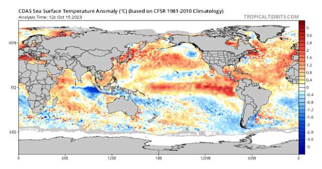
Figure 1: Current SST anomalies showing positive IOD dominating the signatures – source Tropical Tidbits https://www.tropicaltidbits.com/analysis/ocean/cdas-sflux_ssta_global_1.png
Districts:
Eyre Peninsula
Isolated brief light showers about Lower Eyre Peninsula with fresh SW/S winds on evening of 21st before clearing on 22nd as new high moves in. Warming up with hot to very hot conditions over the West Coast and NW Portions of the Eyre Peninsula on 23rd with temperatures reaching the high 30’s ahead of a trough bringing much cooler conditions with a fresh to strong and gusty SW change with isolated coastal showers during the evening. Onshore flow persisting on 24th with light coastal showers ahead of an upper trough passing to the south of the state with colder air which will briefly increase shower activity early on 25th before easing later. A strong 1038hpa high moving in thereafter with fine conditions prevailing, mild about the coasts but grading to warm to hot inland by the 28th. Weak trough on 29th with very isolated shower activity ahead of weak front approx 31st with light onshore showers. Rainfall for period 1-2mm about the Lower Eyre Peninsula coastline, otherwise less than 1mm or nothing at all for the remainder.
Upper North
Isolated brief light showers early on 22nd near the windward Spencer Gulf coastline before clearing as a new high moves in. Warming up with warm to possibly hot conditions in the far N on 23rd with temperatures reaching near 30C ahead of a trough bringing much cooler conditions with a fresh to strong and gusty SW change in the early hours of 24th. Onshore flow persisting during 24th with light showers in the south and near the Spencer Gulf. Upper trough passing to the south of the state with colder air which will briefly increase shower activity during 25th before easing later but chiefly in the south only and likely remaining dry in the northern half. A strong 1038hpa high moving in thereafter with fine conditions prevailing, mild to warm at first but grading to warm to hot inland by the 29th. Weak trough later on 29th with very isolated shower activity ahead of weak front approx. 31st with possible light showers in the far south. Rainfall for period less than 1mm, with many areas receiving nothing at all across the northern half.
Lower North
Isolated brief light showers early on 22nd near the windward Spencer Gulf coastline and far south of the district before clearing as a new high moves in. Warming up with warm conditions in the far N on 23rd with temperatures reaching the high 20’s ahead of a trough bringing much cooler conditions with a fresh to strong and gusty SW change in the early hours of 24th. Onshore flow persisting during 24th with light showers, chiefly in the south and near the Spencer Gulf coast. Upper trough passing to the south of the state with colder air which will briefly increase shower activity during 25th before easing later. A strong 1038hpa high moving in thereafter with fine conditions prevailing, mild to warm at first but grading to warm to hot inland by the 29th. Weak trough later on 29th with very isolated shower activity ahead of weak front approx. 31st with possible light showers. Rainfall for period less than 1-2mm, with some locations receiving little if any rainfall.
Yorke Peninsula
Isolated brief light showers about the foot of the Peninsula with fresh SW/S winds on evening of 21st before clearing on 22nd as new high moves in. Warming up warm conditions on 23rd with temperatures reaching the high 20’s ahead of a trough bringing much cooler conditions with a fresh to strong and gusty SW change with isolated coastal showers during the very late evening or very early hours of the 24th. Onshore flow persisting on 24th with light coastal showers ahead of an upper trough passing to the south of the state with colder air which will briefly increase shower activity from early on 25th before easing later. A strong 1038hpa high moving in thereafter with fine conditions prevailing, mild about the coasts but grading to warm to hot in the north by the 29th. Weak trough later on 29th with very isolated shower activity ahead of weak front approx. 31st with light onshore showers. Rainfall for period 1-3mm about the foot or southern half of the Peninsula, otherwise less than 1mm for the remainder.
Kangaroo Island
Isolated brief light showers with fresh SW/S winds on evening of 21st before clearing on 22nd as new high moves in. Warming up warm conditions on 23rd with temperatures reaching the mid 20’s ahead of a trough bringing much cooler conditions with a fresh to strong and gusty SW change with isolated showers during the very late evening or very early hours of the 24th. Onshore flow persisting on 24th with scattered light showers ahead of an upper trough passing to the south of the state with colder air which will increase scattered shower activity from early on 25th before easing later. A strong 1038hpa high moving in thereafter with fine conditions prevailing, cool to mild initially but grading to warm by the 29th. Weak trough later on 29th with very isolated shower activity ahead of weak front approx. 31st with a band of light showers. Rainfall for period 3-5mm about but decreasing to less than 1-2mm for parts of the north coast.
Adelaide Plains
Isolated brief light showers during with fresh SW/S winds on evening of 21st before clearing on 22nd as new high moves in. Warming up warm conditions on 23rd with temperatures reaching the high 20’s ahead of a trough bringing much cooler conditions with a fresh to strong and gusty SW change with isolated coastal showers during the very early hours of the 24th. Onshore flow persisting on 24th with light coastal showers ahead of an upper trough passing to the south of the state with colder air which will briefly increase shower activity from early on 25th before easing later. A strong 1038hpa high moving in thereafter with fine conditions prevailing, mild about the coasts but grading to warm to hot over the outer northern plains by the 29th. Weak trough later on 29th with very isolated shower activity ahead of weak front approx. 31st with light onshore showers. Rainfall for period 2-3mm about the foothills down to 1-2mm for the remainder.
Mt.Lofty Ranges
Isolated showers during with fresh SW/S winds on evening of 21st before clearing on 22nd as new high moves in. Warming up warm conditions on 23rd with temperatures reaching the mid to high 20’s ahead of a trough bringing much cooler conditions with a fresh to strong and gusty SW change with isolated coastal showers during the very early hours of the 24th. Onshore flow persisting on 24th with light showers ahead of an upper trough passing to the south of the state with colder air which will briefly increase shower activity from early on 25th before easing later. A strong 1038hpa high moving in thereafter with fine conditions prevailing, mild about the southern coasts and ranges but grading to warm to hot over the Barossa by the 29th. Weak trough later on 29th with very isolated shower activity ahead of weak front approx. 31st with a band of light showers. Rainfall for period 3-6mm with perhaps some isolated falls up to 10mm about known wet spots, otherwise less than 3mm for most of the remainder.
Riverland/Mallee
Isolated brief light showers late 21st and early on 22nd in the far SW of the Mallee before clearing as a new high moves in. Warming up with warm to possibly hot conditions about the Riverland on 23rd with temperatures reaching near 30C ahead of a trough bringing much cooler conditions with a fresh to strong and gusty SW change in the early hours of 24th. Onshore flow persisting during 24th with light showers in the south of the Mallee. Upper trough passing to the south of the state with colder air which will briefly increase shower activity during 25th but mostly for the Mallee only with limited penetration into the Riverland. A strong 1038hpa high moving in thereafter with fine conditions prevailing, mild to warm at first but grading to warm to hot by the 29th. Weak trough later on 29th with very isolated shower activity ahead of weak front approx. 31st with possible light showers in the far south of the Mallee. Rainfall for period less than 1-3mm over the south of the Mallee decreasing to less than 1mm further north with many areas receiving nothing at all across the Riverland.
Upper SE
Isolated showers late 21st and early on 22nd before clearing as a new high moves in. Warming up with warm conditions on 23rd with temperatures reaching the mid to high 20’s ahead of a trough bringing much cooler conditions with a fresh to strong and gusty SW change in the early hours of 24th. Onshore flow persisting during 24th with light showers, possibly scattered near the Lower SE border. Upper trough passing to the south of the state with colder air which will further increase shower activity during 25th before clearing later. A strong 1038hpa high moving in thereafter with fine conditions prevailing, mild to warm at first but grading to warm to hot by the 29th. Weak trough later on 29th with very isolated shower activity ahead of weak front approx. 31st with a band of light showers. Rainfall for period generally 1-3mm however possible totals to 5mm near the Lower SE border. Totals decreasing towards the N and NE of the district down to less than 1mm in some locations.
Lower SE
Scattered showers with blustery and cold conditions late 21st and early on 22nd as deep low passes to the south of the state. Showers clearing early 22nd as a new high moves in. Warming up with mild to warm conditions on 23rd with temperatures reaching the mid 20’s ahead of a trough bringing much cooler conditions with a fresh to strong and gusty SW change in the early hours of 24th. Onshore flow persisting during 24th with scattered showers, more frequent in the south. Upper trough passing to the south of the state with colder air which will further increase shower activity during 25th including possible small hail during the afternoon with convection before clearing later. A strong 1038hpa high moving in thereafter with fine conditions prevailing, cool at first but grading to warm by the 29th. Weak trough later on 29th with very isolated shower activity ahead of weak front approx. 31st with a band of light showers. Rainfall for period generally 4-8mm however possible totals to 15mm near the Southern coast. Totals decreasing towards the N and NE of the district down to less than 3-4mm in some locations.
Western VIC
Scattered showers with blustery and cold conditions over the SW District late 21st and during the morning of 22nd as deep low passes to the south of the state. Showers clearing during the mid to late afternoon on 22nd as a new high moves in. Warming up with mild to warm conditions on 23rd with temperatures reaching the mid to high 20’s over the Mallee ahead of a trough bringing much cooler conditions with a fresh to strong and gusty SW change during the morning of 24th. Onshore flow persisting during 24th with scattered showers over the SW district and possible mid-level showers with a half a chance of a rumble over the Wimmera and Mallee. Upper trough passing to the south of the state with colder air which will further increase shower activity over the Wimmera and SW District during 25th including possible small hail during the afternoon with convection before clearing later. A strong 1038hpa high moving in thereafter with fine conditions prevailing, cool at first but grading to warm by the 29th. Weak trough later on 29th or early 30th with very isolated shower activity ahead of weak front approx. 31st with a band of light showers. Rainfall for period generally 4-8mm over the SW District however possible totals to 15mm near the Southern coast. Totals decreasing towards the Wimmera with 2-4mm, and the Mallee unfortunately will see little rainfall and generally less than 1mm.
Final Notes
- Mature Positive IOD now with a peak likely currently occurring
- Slow weakening of Positive IOD through November with more rapid weakening in December
- El Nino weak but should push to moderate levels by December but overall impact is not significant
- Watch for rapid warming around the top end of Australia as the build-up gets going with soupy seas by December enhancing strong diurnal thunderstorms across the top end
- November and December the prime months for heat as troughs and fronts drag that air south with a good chance of thunderstorms
- Jan-March sees a standard summer pattern across SA but with increasing moisture over the tropics as El Nino breaks down although the monsoon won’t be significant
- Autumn should see greater moisture intrusions into the mainland with much better chances of reliable breaking rain when compared to the last 2 seasons
Link to temporary blog website: https://farmweathersa.blogspot.com/
Happy Farming and Cheers from The Weatherman
*Note – For interest only, all thoughts are of The Weatherman and may not be reproduced without my consent.


Comments
Post a Comment