August 2023 Update SA
August 2023 update SA
*Forecast prepared between August 15th-16th
2023
Review:
G’Day everyone, I hope you are keeping well as we move
into mid-August, and no doubt many of you are anxious about the months ahead,
and certainly hope we can at least get a little bit of rain whilst we have a
good window here through mid-August, the expected time for systems this month.
I will explain more in the next section.
The first half of the month has for the most part been
quite dry with only weak systems bringing light falls over the space of 2
weeks. The best effort was a weak cut off low with some rain areas on the 12th
and a more concentrated rainband along the jetstream axis across southern and
some eastern agricultural districts, however a lot of this was still quite a ways south with a narrow area from Southern Adelaide
through to Lameroo receiving 5-15mm totals generally. North of this, the falls
tapered off with only scattered light totals. Many districts are now beginning
to feel the pinch of a dry start to the month, and will no doubt welcome the
mid-month flurry of fronts expected however it won’t last that long and nor
will it penetrate well past the ranges. Snowtown for example has only received
a mere 3.8mm this month which is very poor for that location.
To top it all off, there has been a
number of frosty mornings as well, especially from the 6th-8th
and again on the 11th and 15th. Wudinna infact received
its coldest ever night with –4C on the 7th.
Meteorological Discussion:
Currently on the 16th we have a moderate high-pressure system over Victoria, and this has been responsible for the very cold and frosty morning statewide on the 16th with a number of centres recording minimums below 0C. To the west across much of SA, a broad area of troughing at the surface is present with a strong jetstream aloft dragging in some moisture from the Indian Ocean. A weak shortwave upper trough also lies over the Bight and will act to lift this moisture as it moves eastwards generating isolated mid-level showers and thunderstorms during the afternoon of the 16th across the West Coast and Southern NW Pastoral District before this spreads to areas of rain for the evening and early hours of the 17th to regions located further E and SE. However due to a lack of focus in the trigger, falls will be fairly patchy with many holes. At least however within the core of the thicker band across parts of the Lower North and northern Yorke Pen, there may be some useful totals ahead of a series of weak to moderate cold fronts in the days after.
On the 17th that aforementioned
cold front will move in from the west bringing with it a band of showers.
This front is due to reach the Eyre Peninsula by around 10:30am and into the
Adelaide region by approx 2:30-3pm in the afternoon. Due to remnant moisture
leftover from the patchy rain areas the evening before, the low levels will be
pre-moistened and as a result, isolated thunderstorms are also possible ahead
of and along/near the cold front, and these may develop over the land areas
anywhere east of about the Spencer Gulf, but more likely over elevated terrain
and off the back of the ranges and Mallee/Riverland during the afternoon. Small
hail is possible in the strongest cores as air aloft will be relatively cold.
The band of showers should have reasonable penetration to the east of the
ranges but will begin to weaken and slide away to the SE later
on in the day. There may be localised heavy dumps inn any solid convective
cells during the afternoon.
In the wake of the cold front, winds will turn a colder W
to SW with blustery conditions and stream showers, however in particular with
another shortwave trough marked by a small pool of cold air aloft due in from
the SW during the mid-evening with a spate of showers with small hail south of
about Victor Harbor, so chiefly the SE Districts and Kangaroo Island as the
core of the coldest air moves through.
On the 18th, a moist WSW to SW flow will become
established with winds easing a little allowing a thicker area of low level
moisture to accumulate under an inversion driving frequent showers across many
districts south of about Port Augusta but especially so in the morning and into
parts of the Lower and Upper North where streams coming off the Spencer Gulf
will enhance local totals. Another weak trough should also move in from the SW
during the day, chiefly across the Eyre Peninsula to drive showers well inland
there too. Shower activity will become more isolated by the evening with only
light drizzly streams off the gulfs (especially into the Melrose area) likely remaining as a high-pressure ridge begins to flatten
the flow out and winds turn more westerly with increasing stability. Isolated
light showers will linger through the 19th although totals will now
be quite insignificant.
Isolated showers are likely to linger on the 20th
about Southern coasts and ranges as well as the Lower SE ahead of a weak front
due to clip the SE corner of the state early on the 22nd with a
narrow band of showers but falls from this again will be minimal. A final weak
front should clip the state again on the 23rd or thereabouts with
isolated light showers in a band before high pressure systems
begins to take hold.
Now this high-pressure system is likely to dominate the
weather for most of the remaining days of the month till perhaps another trough
system born out of the ever-heating inland WA makes a moves
towards the SE for either the last couple of days of the month or very early
September. This should try to link up with some colder air but remains to be
seen if any significant interaction can occur.
I do expect a couple of strong colder blasts out of the
deep south through September which will drive dry air inland which will then
sink and dry out the low levels across the interior, promoting frost. But being
so dry on the flip side, it also won’t take long to warm up either when the
heat presses down from inland WA, especially so later in the month when the pre-frontal
troughs should accompany most frontal westerly systems.
The main frost risk mornings for the rest of the month
are around the 23rd and 24th with a slight risk and again
around the 27th and 28th with a slight to moderate risk,
with even a heavy chance in pockets for the Riverland and SE Districts and well
as Western VIC.
Climate Drivers:
The Pacific has shown further signs of a slow progression
to El Nino. Whilst NOAA have already declared one, the BoM have not with the
criteria not being met however I can assure you that it will be, and it is only
a matter of time for that. The main moves in the Nino 3.4 region are still to
come through spring with a slight move of the warmest anomalies away from the
South American coastline towards the west into the Nino 3.4 region (essentially
south of about Hawaii). Trade winds are weaker now in the Western Pacific for
the first time in about 4 years which has been a long time coming for those.
The persistent warm water off PNG and surrounds still lingers but is weakening
and I expect this to slowly continue however overall, much of the Pacific basin
will still be fairly warm.
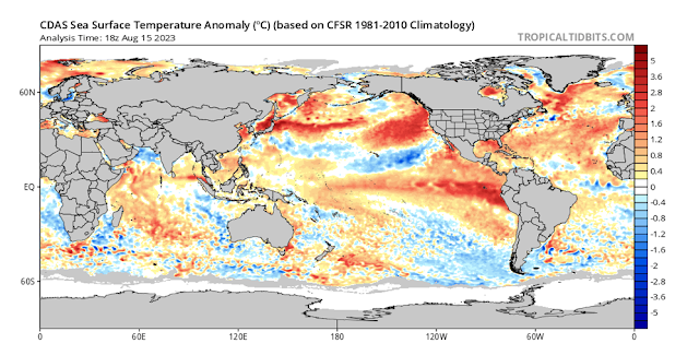
Figure 1: Current SST anomalies – source Tropical Tidbits
https://www.tropicaltidbits.com/analysis/ocean/cdas-sflux_ssta_global_1.png
Now the Indian has made some further ground in the last 2
weeks with warming across the Western basin near the horn of Africa. In the
Eastern box we have also seen some warming to the south where the cooler
anomalies were 2 weeks ago but also some cooling towards the northern and
western portions of the box as we start to see the early stages of the
traditional upwelling off Java and Sumatra, which then extends west. This will
ebb and flow in the coming weeks but gradually become more established whilst
the west should now stay quite warm, much warmer than average and it is this
difference in anomalies that will allow the index to be positive. Currently it
is around +0.32C and rising. All pointers are for further development through
September with a peak probably in October which should allow for a dry spring
across the state with general below average rainfall.
The SAM is showing no signs either way at this stage with
neutral values persisting. A few brief fronts mid-month may cause a dip into
the negative range but probably not enough to go past neutral values before we
trend positive again into September.
As for the MJO, it is currently still quite weak in the
Australian region with only weak Westerly Wind Bursts expected to push into the
Pacific in the coming days. There is however a chance this may strengthen a
smidge to moderate strength there now given trade winds have dropped in recent
weeks, allowing a better penetration across the Pacific and assisting El Nino
to further develop. However no major bursts are expected for the foreseeable
future.
Districts:
Eyre Peninsula
Broad low-pressure trough with jetstream aloft will
generate isolated showers and thunderstorms from mid-afternoon on 16th,
tending to areas of rain through the evening. Cold front due mid-morning on 17th
with a band of showers and possible isolated thunderstorms. Winds becoming
colder and fresh to strong out of the W to SW in wake of front with showers
becoming isolated at first. Cold pool with trough to move in during late
afternoon and evening with an increase in showers once again. Secondary trough
embedded in moist SW flow to bring frequent showers and heavy drizzle areas on
18th before this activity becomes isolated in the evening. Good
inland penetration due to daytime timing. Isolated light lingering showers on
19th, chiefly about Lower Eyre Peninsula. Weak trough in onshore
flow on 20th with further light showers about the western and
southern coastlines. Successive weak fronts on 22nd and 23rd
with light showers about Lower Eyre Peninsula before a new ridge moves in
clearing shower activity. Fine weather with warm to hot conditions and
freshening N winds from 28th-30th ahead of a trough
system extending from the west with isolated showers and possible
thunderstorms. Slight frost risk 23rd and again 26th-27th.
Rainfall for period 15-25mm generally with isolated 30mm totals about Lower
Eyre Peninsula. Totals decreasing towards NE Eyre Pen to around 7-15mm.
Upper North
Broad low-pressure trough with jetstream aloft will
generate patchy rain through the evening of 16th and into the early hours of
the 17th. Cold front due early to mid-afternoon on 17th
with a band of showers and possible isolated thunderstorms. Isolated afternoon
showers and thunderstorms also developing ahead of front on elevated terrain
with a chance of small hail in strongest cores. Winds becoming colder and fresh
to strong out of the W to SW in wake of front with showers becoming isolated.
Cold pool with trough to move in during late evening with an increase in
showers once again before some streams setup off
the Spencer Gulf with frequent showers, chiefly in the south and west of the
district and near exposed slopes and higher terrains. Secondary trough embedded
in moist SW flow to keep frequent shower activity going into the early
afternoon on 18th before this activity becomes isolated in the
evening with the exception of the Melrose area
which may still see drizzly stream showers moving in off the Spencer Gulf. All
shower activity will be more isolated north of about Port Augusta. Isolated
light lingering showers on 19th, chiefly in the south and near
higher terrain. Successive weak fronts clipping SE of state on 22nd
and 23rd with only very isolated light showers in the south before a
new ridge moves in clearing shower activity. Fine weather with warm to hot
conditions and freshening N winds from 28th-30th ahead of
a trough system extending from the west with isolated showers and possible
thunderstorms. Slight frost risk 23rd and 24th and a slight to
moderate risk on 27th and 28th. Rainfall for period
15-25mm generally with isolated 30-35mm totals about higher terrain and near
Melrose. Totals decreasing towards the Flinders to around 5-15mm and also off the backs of the ranges and towards the
NE of the district down to around 5-8mm.
Lower North
Broad low-pressure trough with jetstream aloft will
generate areas of rain through the evening of 16th and into the early hours of
the 17th. Cold front due early to mid-afternoon on 17th
with a band of showers and possible isolated thunderstorms. Isolated afternoon
showers and thunderstorms also developing ahead of front on elevated terrain with
a chance of small hail in strongest cores. Moderate falls possible. Winds
becoming colder and fresh to strong out of the W to SW in wake of front with
showers becoming isolated. Cold pool with trough to move in during the mid to
late evening with an increase in showers once again before some streams setup off the Spencer Gulf with frequent
showers and moderate falls, chiefly in the west and north of the district and
near exposed slopes and higher terrains. Secondary trough embedded in moist SW
flow to keep frequent shower activity going into the early afternoon on 18th
before this activity becomes isolated in the evening. Isolated light lingering
showers on 19th near higher terrain. Successive weak fronts clipping
SE of state on 22nd and 23rd with only very isolated
light showers before a new ridge moves in clearing shower activity. Fine
weather with warm to hot conditions and freshening N winds from 28th-30th
ahead of a trough system extending from the west with isolated showers and
possible thunderstorms. Slight frost risk 23rd and 24th and a slight
to moderate risk on 27th and 28th Rainfall for period
20-30mm generally with isolated 30-45mm totals about higher terrain. Totals
decreasing towards the backs of the ranges and towards the NE of the district
down to around 7-12mm.
Yorke Peninsula
Broad low-pressure trough with jetstream aloft will
generate isolated showers and thunderstorms from mid evening on 16th,
tending to patchy rain overnight, more consistent in the north. Cold front due
early afternoon on 17th with a band of showers and isolated
thunderstorms. Winds becoming colder and fresh to strong out of the W to SW in
wake of front with showers becoming isolated at first. Cold pool with trough to
move in during the early to mid-evening with an increase in showers once again.
Secondary trough embedded in moist SW flow to bring frequent showers on 18th
before this activity becomes isolated in the evening. Showery streams setting
up across N Yorke Pen from early morning to enhance local totals. Isolated
light lingering showers on 19th, chiefly about the foot. Weak trough
in onshore flow on 20th with further light showers about the foot
once again. Successive weak fronts on 22nd and 23rd with
light showers about the foot and central Peninsula. Fine weather with warm to
very warm conditions and freshening N winds from 28th-30th
ahead of a trough system extending from the west with isolated showers and
possible thunderstorms. Slight frost risk 23rd-24th and again 27th
and 28th more likely in the far north. Rainfall for period 15-25mm
generally with isolated 30-35mm totals in far north. Totals decreasing towards
the foot and the SE portions to around 10-15mm.
Kangaroo Island
Broad low-pressure trough with jetstream aloft will
generate isolated showers from late evening on 16th, continuing into
early 17th. Cold front due early morning on 17th with a
band of showers and isolated thunderstorms. Winds becoming colder and fresh to
strong out of the W to SW in wake of front with showers becoming isolated at
first. Cold pool with trough to move in during the early to mid-evening with an
increase in showers once again. Slight chance of small hail in stronger cells.
Secondary trough embedded in moist SW flow to bring scattered showers on 18th
before this activity becomes isolated in the evening. Isolated light lingering
showers on 19th in onshore westerly flow. Weak trough in onshore flow on 20th
with further light showers. Successive weak fronts also on 22nd and
23rd with light showers. Fine weather with mild to warm conditions
and freshening N winds from 28th-30th ahead of a trough
system extending from the west with isolated showers and possible
thunderstorms. Slight frost risk 24th and again 27th and 28th.
Rainfall for period 8-15mm generally with isolated 15-20mm totals in west.
Totals decreasing towards the eastern end to around 6-8mm.
Adelaide Plains
Broad low-pressure trough with jetstream aloft will
generate areas of rain, more consistent in the north. Cold front due
mid-afternoon on 17th with a band of showers and isolated
thunderstorms. Winds becoming colder and fresh to strong out of the W to SW in
wake of front with showers becoming isolated at first. Cold pool with trough to
move in during the mid-evening with an increase in showers once again.
Secondary trough embedded in moist SW flow to bring frequent showers on 18th
before this activity becomes isolated in the evening. Isolated light lingering
showers on 19th, chiefly about the southern suburbs. Weak trough in
onshore flow on 20th with further light showers about the southern
suburbs. Successive weak fronts on 22nd and 23rd with
light showers. Fine weather with warm to very warm conditions and freshening N
winds from 28th-30th ahead of a trough system extending
from the west with isolated showers and possible thunderstorms. Slight frost
risk 23rd-24th and again 27th and 28th more likely about
the outer plains. Rainfall for period 12-25mm generally with isolated 30mm
possible about foothills. Totals decreasing to around 10-12mm about the western
suburbs.
Mt.Lofty Ranges
Broad low-pressure trough with jetstream aloft will
generate areas of rain, more consistent in the north. Cold front due
mid-afternoon on 17th with a band of showers and isolated
thunderstorms. Isolated showers and thunderstorms developing ahead of front
also off back of ranges. Winds becoming colder and fresh to strong out of the W
to SW in wake of front with showers becoming isolated at first. Cold pool with
trough to move in during the mid-evening with an increase in showers once again
with small hail possible near the Southern Coasts. Secondary trough embedded in
moist SW flow to bring frequent showers on 18th before this activity
becomes isolated in the evening. Isolated light lingering showers on 19th,
chiefly about the southern Fleurieu. Weak trough in onshore flow on 20th
with further light showers about the southern Fleurieu. Successive weak fronts
on 22nd and 23rd with light showers, tending scattered
towards the Southern coasts and ranges. Fine weather with warm to very warm
conditions and freshening N winds from 28th-30th ahead of
a trough system extending from the west with isolated showers and possible
thunderstorms. Slight frost risk 23rd-24th and again 27th and 28th,
more likely about the Barossa and low-lying valleys. Rainfall for period
18-28mm generally with isolated 30-35mm possible about higher peaks. Totals
decreasing to around 8-18mm off the back side of the ranges.
Riverland/Mallee
Broad low-pressure trough with jetstream aloft will
generate areas of rain early hours of the 17th, patchier in the
Riverland. Cold front due late afternoon on 17th with a band of
showers and possible isolated thunderstorms. Isolated afternoon showers and
thunderstorms also developing ahead of front with a chance of small hail in
strongest cores. Localised heavy falls in stronger cores. Winds becoming colder
and fresh to strong out of the W to SW in wake of front with showers becoming
isolated. Cold pool with trough to move in late evening to early hours of 18th
with an increase in showers once again, but mostly about the southern Mallee
with the Riverland seeing only very isolated showers in the south and far west
closer to the back of the ranges. Secondary trough embedded in moist SW flow to
keep shower activity going into the early afternoon on 18th before
this activity becomes isolated in the evening. Isolated light lingering showers
on 19th. Successive weak fronts clipping SE of state on 22nd
and 23rd with only very isolated light showers towards the Southern
Mallee before a new ridge moves in clearing shower activity. Fine weather with
warm to hot conditions and freshening N winds from 29th-30th
ahead of a trough system extending from the west with isolated showers and
possible thunderstorms. Slight frost risk 23rd and 24th and a slight
to moderate risk on 27th and 28th Potential for heavy
frost on 27th or 28th in prone holes. Rainfall for period
8-15mm generally with isolated 15-25mm totals about the southern Mallee and
towards the far SE. Totals decreasing towards the Riverland down to around
5-8mm.
Upper SE
Broad low-pressure trough with jetstream aloft will
generate areas of rain early hours of the 17th, patchier in the
south. Cold front due late afternoon on 17th with a band of showers,
possibly tending to rain at times and possible isolated thunderstorms. Isolated
afternoon showers and thunderstorms also developing ahead of front with a
chance of small hail in strongest cores. Localised heavy falls in stronger
cores. Winds becoming colder and fresh to strong out of the W to SW in wake of
front with showers becoming isolated. Cold pool with trough to move in late
evening to early hours of 18th with an increase in showers once again with
possible small hail near the Coorong coast. Secondary trough embedded in moist
SW flow to keep shower activity going into the early afternoon on 18th
before this activity becomes isolated in the evening. Isolated light lingering
showers on 19th. Successive weak fronts clipping SE of state on 22nd
and 23rd with only very isolated light showers towards the Coorong
coast and adjacent inland before a new ridge moves in clearing shower activity.
Fine weather with warm to very warm conditions and freshening N winds from 29th-30th
ahead of a trough system extending from the west with isolated showers and
possible thunderstorms. Slight frost risk 23rd and 24th and a slight
to moderate risk on 27th and 28th Potential for heavy
frost on 27th or 28th in prone holes. Rainfall for period
10-18mm generally with isolated 15-25mm totals possible. Localised lower
pockets, chiefly towards the NW coastline down to around 8-10mm.
Lower SE
Broad low-pressure trough with jetstream aloft will
generate patchy light rain early hours of the 17th in the far north
but remaining mostly dry in the south. Cold front due late afternoon on 17th
with a band of showers, possibly tending to rain at times and possible isolated
thunderstorms. Isolated afternoon showers and thunderstorms also developing
ahead of front with a chance of small hail in strongest cores. Localised heavy
falls in stronger cores. Winds becoming colder and fresh to strong out of the W
to SW in wake of front with showers becoming isolated. Cold pool with trough to
move in late evening to early hours of 18th with an increase in showers once
again with possible small hail. Secondary trough embedded in moist SW flow to
keep shower activity going into the early afternoon on 18th before
this activity becomes isolated in the evening. Isolated light lingering showers
on 19th. Successive weak fronts clipping SE of state on 22nd
and 23rd with only very isolated light showers towards the western
coast and adjacent inland before a new ridge moves in clearing shower activity.
Fine weather with warm to very warm conditions and freshening N winds from 29th-30th
ahead of a trough system extending from the west with isolated showers and
possible thunderstorms. Slight frost risk 23rd and 24th and a slight
to moderate risk on 27th and 28th. Potential for heavy
frost on 27th or 28th in prone holes. Rainfall for period
12-25mm generally with isolated 25-30mm totals possible. Localised lower
pockets, chiefly towards the NE corner down to around 10-12mm.
Western VIC
Broad low-pressure trough with jetstream aloft will
generate patchy light rain early on the 17th about the Mallee and
Wimmera but remaining mostly dry in the southwest district with only small
patches of light rain there. Cold front due early evening on 17th
with a band of showers, possibly tending to rain at times and possible isolated
thunderstorms. Isolated afternoon showers and thunderstorms also developing
ahead of front with a chance of small hail in strongest cores. Localised heavy
falls in stronger cores. Winds becoming colder and fresh to strong out of the W
to SW in wake of front with showers becoming isolated. Cold pool with trough to
move in late evening to early hours of 18th with an increase in showers once
again with possible small hail about the SW District. Secondary trough embedded
in moist SW flow to keep shower activity going into the early afternoon on 18th
before this activity becomes isolated in the evening. Isolated light lingering
showers on 19th. Successive weak fronts clipping southern portions
of SW VIC on 22nd and 23rd with only very isolated light
showers towards the southern coast and adjacent inland before a new ridge moves
in clearing shower activity. Fine weather with warm to very warm conditions and
freshening N winds from 29th-30th ahead of a trough
system extending from the west with isolated showers and possible
thunderstorms. Slight frost risk 23rd and 24th and a slight to
moderate risk on 27th and 28th. Potential for heavy frost
on 27th or 28th in prone holes. Rainfall for period
12-25mm generally with isolated 25-30mm totals possible. Localised lower totals
however over the Mallee and towards the NSW border near Mildura down to around
5-8mm.
Final Notes
· El Nino and positive IOD in formation still, with main
impacts to be felt through spring with below average rainfall for that period
· Fast moving spring fronts and associated pre-frontal
troughs will bring a greater damaging wind risk with dust possible and warm to
hot windy N to NW winds
· Watch for rapid temperature jumps late month and into
September, firstly across the far west of the state before this extends to all
districts through later September and into October
· Large diurnal temperature ranges from cold nights with
frost to warmer days in September likely which may be challenging
· Useful totals in current mid-month wetter phase may act
to mitigate dry weather ahead to some degree for those that receive falls of
over 25mm
· Outlook for summer is hot and dry however, increasing
moisture building in the latter portions with a warming ocean around the
mainland combined with El Nino breakdown likely to deliver better rainfall
potential into autumn 2024
Link to temporary blog website: https://farmweathersa.blogspot.com/
Happy Farming and Cheers from The Weatherman
*Note – For interest only, all thoughts are of The
Weatherman and may not be reproduced without my consent.


Comments
Post a Comment