August 2023 outlook SA
August 2023 outlook SA
*Forecast prepared between July 31st-August 3rd 2023
Review:
G’Day everyone, hope you are keeping well. August is now upon us and a critical month for so many with it often being a barometer with respect to how things go for many districts. A decent month here will no doubt help many and certainly whilst I can’t see anywhere near the levels of June, it will be a little better than July which has been the expectation for a number of months now.
Taking a look back at July now and it certainly was in contrast to June which was quite wet overall. High pressure systems began to show their muscle, bringing frosts, and longer dry spells with inconsistent and unreliable rainfall occurring allowing some drying out after the good falls in June. The areas which no doubt felt the pinch the most were those with increasing northern extent, especially north of Goyder's Line.
Notable events through July rainfall wise were hard to come by with the best system coming on the 6th over Northern Agricultural areas and Riverland with the 22nd being better for the Southern Agricultural areas. Frost events were the number 1 significant events across the month with a 3-4 day period of temperature close to or below freezing from the 16th-19th and again a snap frost on the 21st especially for the Riverland, Mallee and many locations across the Lower and Upper North.
A look back now at the July outlook issued at the start of the month to see how things panned out:
“So, to the all-important July outlook and broadly speaking we will see a drier month than June, especially inland. Below average rainfall across the NW tending closer to average for the eastern part of the NE Pastoral. There will be a grading from below average rainfall across northern agricultural areas to near average across the southern agricultural areas. The most prone to below average rainfall include the Northern Eyre Peninsula and Upper North as well as the Riverland. The Mallee will be closer to average but probably still slightly below. Most other districts should come around their average. The greatest chances of above average falls will be about Kangaroo Island
and the Lower SE and potentially the tip and western portions of Eyre Peninsula and this is primarily due to the expected zonal pattern.”
The main dry trend and expectation certainly was true however it came on with more grunt even than I thought with below average rainfall and areas of very much below average rainfall. The Upper North and inland of the NW Pastoral were the worst compared to their averages which is reflected well in the percentages chart. There was a slight improvement towards the Eastern Mallee and both the Upper and Lower SE however they still fell short of average rainfall. The NE corner of the state received some above average rainfall thanks to a lingering cloudband. All in all the drying trend was captured but not to the full extent.
I’ve also included another chart in Figure 4 showing the current growing season rainfall from May through to the end of July. I’ve mentioned in advance that I expect this period to be below average rainfall wise across the agricultural areas, but especially north of Goyders LIne. We can see that despite a wet June, we are already running behind the average in these areas, not too far from the Goyders Line itself. The Southern and parts of the Eastern Agricultural areas are still holding just above the average however by the end of October, I think all of this will end up below as well, just not to the extent of further north. There is a pocket over NW Eyre Peninsula that isn’t doing too well at all and this is also an area that is going to warm up rapidly through Spring really putting the squeeze on.
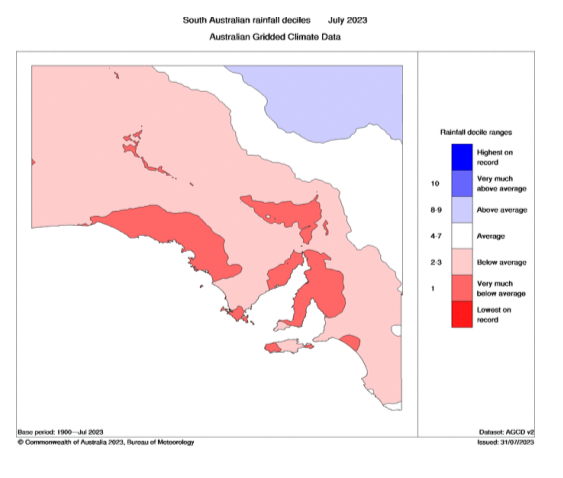

Figure 2: July 2023 rainfall percentages – source BoM http://www.bom.gov.au/climate/


Meteorological Discussion:
So with August now here, the conditions are about to start making a rapid change. Whilst the broad dryness from July will continue, I do expect a few better systems to line up through mid to later month to at least give us a brief reprieve however the inland oven that is the desert of WA has had a dry couple of months and with the continual high pressure and push towards a Positive IOD and El Nino, this area will be firmly in the gun to rapidly heat up and advect warm to hot air SE ahead of cold fronts and spring troughs – some of which will be fast moving and quite dry in nature. It will feel like we have gone from 15C to 30C in the blink of an eye at times when we do get these warm to hot and windy N/NW winds ahead of these systems. The first already due on the 3rd with a marked jump in temperatures to the low to mid 20’s across the agricultural areas ahead of a weakening cold front and associated low to the south.
Overall though the trend of strong high pressure systems will continue for the first half of the month with a number of strong 1037-1039hPa highs once again moving across the mainland and into the Tasman and with this comes the risk of frost although on the slight to moderate end rather than the
heavy end initially. Once we do get a stronger cold surge north out of the deep south, something I envisage mid to late month, the next dominant high pressure after that is the one I am going to be watching the most for more moderate to even potentially heavy frost in the most prone areas.
Onto the current situation and we have a large and dominant high pressure system located over the Tasman Sea directing a NE-N airstream across the state. A freshening N wind, strong at times is expected on the 3rd with warm conditions across many districts, grading to hot near the West Coast and Far West areas as well as parts of the NW Pastoral. All of this will precede a weakening cold front with a deepening low forming south of the Bight before it dives away to the SE. The cold front will contain a patchy rainband and some mid-level showers. There is a slight chance of an isolated thundery shower amongst it as well, although most likely out over the Far West, West Coasts and Eyre Peninsula later on the 3rd. Mid-level showers, some possibly thundery will then extend across remaining districts overnight and into the morning of the 4th as the front moves eastwards and weakens further. Shower activity contracting out of the state by the evening as a new strong 1039hPa high moves in from the west. This large high will dominate the weather until approx the 9th when another weak front will move through with scattered showers, chiefly in the south.
Another weaker high should then move through before a potential weak cut off low develops from the W or NW from the 12th or 13th with further shower and possible thunderstorm activity. However, for the most part, rainfall will be sparse and patchy for these first 2 weeks of the month. Warm air is likely to be advected down ahead of the cut off low once again. A clearance is then expected before potentially a better system after mid-month however this will feature for the mid-month update.
Overall, my August outlook is for average to below average rainfall for most districts but not quite to the levels of July. Areas in the Upper North, Lower North, Eyre Peninsula (chiefly northern), Riverland and Mallee are the most susceptible but also into Yorke Peninsula and the general Central Districts including Adelaide and the Mt.Lofty Ranges, although a little better here. Kangaroo Island and the SE Districts may come closer to the average. Potential pockets of very much below average rainfall are possible across the NW and NE interior, especially towards the N/NE. The far west of the state may see some average to slightly above areas from NW moisture intrusions along sliding troughs and increased jetstream activity.
Climate Drivers:
There has been a bit of discussion across various channels and online pages as to whether or not we have an El Nino or if we will have one at all. There are no two ways about it, what we see in the oceans right now is an El Nino, already declared by NOAA and likely very soon by the BoM. The main differences between previous strong El Nino’s is the gradient of the anomalies from east to west. We have so much warm water globally that we are still getting an El Nino, which actually is a testament to the strength of the heat in the east. If we had typically colder SSTs near Australia like 1997, 2015 etc then the resultant measurement of El Nino would surpass both of them. So rather than your old school traditional El Nino, we simply have a more powerful and larger area of warmer water on the surface stretching over a much bigger area, but with a focus still in the Eastern Pacific. The take-home message from this is with so much warmer water than usual further west such as the Coral Sea and waters east of PNG, we can expect greater moisture to be available from the N to NE during the warmer months and into autumn next year should this warmth persist. El Nino’s often break down later in summer and through autumn and typically can bring an increase in rainfall, especially through inland eastern Australia. So, with extra warmth present, this may be greater than usual so it will pay to watch very closely for the first 4-5months of 2024.
Moving on to the Indian now and we have made some small ground towards a positive IOD since the last update 2 weeks ago. In Figure 5, I have added the Eastern and Western IOD measurement boxes to help visualise the areas we are talking about and the water immediately surrounding them. We can see from the image that despite the western box being larger than the eastern box (I’ve always wondered why this is the case), the western box currently has more slightly warmer than average water than the Eastern box which, has a tiny bit more slightly cooler than average water. However, it should be noted that there is quite a bit of cooler water to the south and SE of the Eastern box which is ever so slowly working its way W/NW as those strong highs over Australia drive trade winds across the region, allowing more colder water to upwell from depths. There is some stubborn colder anomalies off the Arabian coastline just north of the box which have in recent weeks contributed to a weak negative spike in the overall measurement. The bigger picture though clearly shows more warmer than average water in the Central to Western portions and cooler than average water In the East all the way from below WA right up to Indonesia.

The SAM has been weekly positive in the last 7 days but currently is almost smack bang on 0 so right in the middle of neutral conditions. Often neutral can lead to a mix of highs and fronts well interspaced and moving into August, that is what looks to be the case with some strong highs and some moderate to strong fronts, with the highs being more common in the first half before mid-month the fronts/lows start to take over for a few weeks but still spaced between weaker high pressure.
The MJO is almost indiscernible atm but is very weak in phase 6 to the east of the mainland. It is forecast to wobble weakly into phases 7 and 8 as we move into August however as we know at this time of the year it doesn’t really favour anything too significant around the mainland or tropics.
Districts:
Eyre Peninsula
Warm and windy day on 3rd with freshening N winds ahead of a cold front bringing patchy rain and mid-level showers from the late evening. Isolated thundery showers possible, chiefly over the Eyre Peninsula in the early hours of 4th. Shower activity lingering in wake of front, though becoming isolated by the late afternoon and largely clearing by evening. Cooler conditions prevailing ahead of a large 1039hPa high pressure system extending from the Bight for the 5th. Weakening front due around 9th with scattered showers, much more isolated with northern extent. Another system due around 12th-13th potentially as a cut off low with further shower activity. Cold nights through 6th-8th and potentially the 11th with a slight frost risk, chiefly inland. Rainfall for the period generally 4-8mm with isolated 10-15mm totals near the tip of Lower Eyre Peninsula and the West Coast of Eyre Pen. Lighter totals further N and NE down to around 3-4mm.
Upper North
Warm and windy day on 3rd with freshening N winds ahead of a cold front bringing a band of mid-level showers on 4th. Isolated shower activity lingering in wake of front, though becoming isolated by the late afternoon and largely clearing by evening. Cooler conditions prevailing ahead of a large 1039hPa high pressure system extending from the Bight for the 5th. Weakening front due around 9th with isolated showers, chiefly afternoon and evening. Another system due around 12th-13th potentially as a cut off low with further shower activity. Cold nights through 6th-8th and potentially the 11th with a slight to moderate frost risk, especially towards the NE of the district. Rainfall for the period generally 3-5mm with isolated 5-10mm totals closer to ranges/elevated terrain and Spencer Gulf. Totals dropping off further north up the Flinders to less than 2mm.
Lower North
Warm and windy day on 3rd with freshening N winds ahead of a cold front bringing a band of mid-level showers on 4th. Slight chance of an isolated thundery shower closer to the gulf. Isolated shower activity lingering in wake of front, though becoming isolated by the late afternoon and largely clearing by evening. Cooler conditions prevailing ahead of a large 1039hPa high pressure system extending from the Bight for the 5th. Weakening front due around 9th with isolated showers, chiefly afternoon and evening. Another system due around 12th-13th potentially as a cut off low with further shower activity. Cold nights through 6th-8th and potentially the 11th with a slight to moderate frost risk, especially towards the N/NE of the district. Rainfall for the period generally 4-6mm with isolated 6-10mm totals closer to ranges/elevated terrain and also the Spencer Gulf. Totals dropping off towards the back side of the ranges to a mere 1-3mm.
Yorke Peninsula
Warm and windy day on 3rd with freshening N winds ahead of a cold front bringing patchy rain and mid-level showers from mid to late evening. Isolated thundery showers possible in the early hours of 4th. Shower activity lingering in wake of front, though becoming isolated by the late afternoon and largely clearing by evening. Cooler conditions prevailing ahead of a large 1039hPa high pressure system extending from the Bight for the 5th. Weakening front due around 9th with scattered showers
about the lower half of the Peninsula, much more isolated with northern extent. Another system due around 12th-13th potentially as a cut off low with further shower activity. Cold nights through 6th-8th and potentially the 11th with a slight frost risk, chiefly towards the N. Rainfall for the period generally 5-7mm with isolated 7-12mm totals near the foot of the Peninsula. Lighter totals further N down to around 3-5mm.
Kangaroo Island
Mild and windy day on 3rd with freshening N winds ahead of a cold front bringing patchy rain and mid-level showers from the evening. Isolated thundery showers possible in the early hours of 4th. Shower activity lingering in wake of front, though becoming isolated by the late afternoon and largely clearing by later evening. Cooler conditions prevailing ahead of a large 1039hPa high pressure system extending from the Bight for the 5th. Weakening front due around 9th with scattered showers and possible isolated thunderstorms. Another system due around 12th-13th potentially as a cut off low with further shower activity. Cold nights through 6th-8th and potentially the 11th with a slight frost risk towards the centre of the island. Rainfall for the period generally 10-15mm with isolated 15-25mm totals near the western end. Totals decreasing towards the eastern end down to around 7-10mm.
Adelaide Plains
Warm and windy day on 3rd with freshening N winds ahead of a cold front bringing patchy rain and mid-level showers from mid to late evening. Isolated thundery showers possible in the early hours of 4th. Shower activity lingering in wake of front, though becoming isolated by the late afternoon and largely clearing by evening. Cooler conditions prevailing ahead of a large 1039hPa high pressure system extending from the Bight for the 5th. Weakening front due around 9th with scattered showers and possible isolated thunderstorms, chiefly afternoon and evening. Another system due around 12th-13th potentially as a cut off low with further shower activity. Cold nights through 6th-8th and potentially the 11th with a slight frost risk, chiefly towards the outer plains. Rainfall for the period generally 8-12mm with isolated 12-18mm totals near the foothills. Lighter totals further N towards the outer plains down to around 5-8mm.
Mt.Lofty Ranges
Mild to warm and windy day on 3rd with freshening N winds ahead of a cold front bringing patchy rain and mid-level showers from mid to late evening. Isolated thundery showers possible in the early hours of 4th. Shower activity lingering in wake of front, though becoming isolated by the late afternoon and largely clearing by evening. Cooler conditions prevailing ahead of a large 1039hPa high pressure system extending from the Bight for the 5th. Weakening front due around 9th with scattered showers and possible isolated thunderstorms, chiefly afternoon and evening and south of the Barossa mostly. Another system due around 12th-13th potentially as a cut off low with further shower activity. Cold nights through 6th-8th and potentially the 11th with a slight frost risk, chiefly towards the Barossa and in any low lying valleys. Rainfall for the period generally 12-18mm with isolated 18-25mm totals near known wet spots and the Southern Fleurieu. Lighter totals further N towards the Barossa and also off the backs of the ranges down towards 5-10mm
Riverland/Mallee
Warm and windy day on 3rd with freshening N winds ahead of a cold front bringing a band of mid-level showers on 4th. Very isolated shower activity lingering in wake of front, though becoming isolated by the late afternoon and largely clearing by evening. Cooler conditions prevailing ahead of a large 1039hPa high pressure system extending from the Bight for the 5th. Weakening front due around 9th with isolated showers, chiefly afternoon and evening. Another system due around 12th-13th potentially as a cut off low with further shower activity. Cold nights through 6th-8th and potentially the 11th with a slight to moderate frost risk, especially towards over the Riverland. Rainfall for the period generally 3-5mm with isolated totals up to 7-10mm down across the Mallee. Totals dropping off further north over the Riverland down to 2-3mm.
Upper SE
Warm and windy day on 3rd with freshening N winds ahead of a cold front bringing a band of mid-level showers from early on the 4th. Shower activity lingering in wake of front, though becoming isolated by the late afternoon and largely clearing by evening, apart from potentially a lingering shower near the Coorong coastline. Cooler conditions prevailing ahead of a large 1039hPa high pressure system extending from the Bight for the 5th. Weakening front due around 9th with scattered showers and possible isolated thunderstorms, chiefly afternoon and evening. Another system due around 12th-13th potentially as a cut off low with further shower activity. Cold nights through 6th-8th and potentially the 11th with a slight frost risk. Rainfall for the period generally 8-12mm with isolated 12-15mm totals in the south. Lighter totals further N towards the Mallee down to around 5-8mm.
Lower SE
Warm and windy day on 3rd with freshening N winds ahead of a cold front bringing a band of mid-level showers from early on the 4th. Scattered shower activity lingering in wake of front, though becoming isolated by the late afternoon and largely clearing by evening, apart from potentially a lingering shower near the coastline. Cooler conditions prevailing ahead of a large 1039hPa high pressure system extending from the Bight for the 5th. Weakening front due around 9th with a band of rain or scattered showers and possible isolated thunderstorms, chiefly afternoon and evening. Another system due around 12th-13th potentially as a cut off low with further shower activity. Cold nights through 6th-8th and potentially the 11th with a slight frost risk. Rainfall for the period generally 15-25mm with isolated 25-30mm totals in the south. Lighter totals further N towards the Upper SE District down to around 10-15mm.
Western VIC
Warm and windy day on 3rd with freshening N winds ahead of a cold front bringing a band of mid-level showers from early on the 4th. Scattered shower activity lingering in wake of front, though becoming isolated by the late afternoon and largely clearing by evening, however showers likely lingering near the SW District coastline. Cooler conditions prevailing ahead of a large 1039hPa high pressure system extending from the Bight for the 5th. Weakening front due around 9th or 10th with a band of rain or scattered showers and possible isolated thunderstorms. Another system due around 12th-13th potentially as a cut off low with further shower activity. Cold nights through 6th-8th and potentially the 11th with a slight frost risk, tending to moderate across the Mallee. Rainfall for the period generally 8-15mm with isolated 15-20mm totals in the south of the SW District Lighter totals further N towards the Mallee down to 2-4mm though some isolated patches up to 10mm are possible here as well. The Wimmera should split the middle at around 5-8mm generally with isolated 10-15mm about the Grampians and far east.
Final Notes
- El Nino and Positive IOD slowly taking shape, both likely in the weak to moderate range
- Inland WA will rapidly heat up through August and September allowing dry heat to advect SE ahead of fast spring troughs and fronts through September to November but also starting in August to a lesser degree.
- Curing N winds ahead of those fast spring systems followed by strong westerly changes with damaging winds at times in stronger systems.
- Below average rainfall through spring, chiefly inland however slightly less impacts with southern extent until about September before the heat begins to change the synoptic scale weather patterns.
- Whilst dry conditions are expected, this spring won’t be to the severity of 1994 or 2006 but possibly closer to 2002 in some locations.
- Thunderstorm activity will be of a drier and higher based nature than last season with less flooding and more wind or hail impacts. Grass fires from lightning a higher risk.
- Early indications for summer is hotter and drier than last summer with more extreme daytime temperatures due to a drier interior.
- However it should be noted the ocean temperatures will be near record levels globally and around Australia which should see a wetter response as this is released for 2024, especially through late summer and autumn.
Link to temporary blog website: https://farmweathersa.blogspot.com/
Happy Farming and Cheers from The Weatherman
*Note – For interest only, all thoughts are of The Weatherman and may not be reproduced without my consent.


Comments
Post a Comment