July 2023 update SA
July 2023 update SA
*Forecast prepared between July 17th-20th 2023
Review:
G’Day everyone, mid-July is already here as we move towards August and before we know it, spring! So far this month the expected drier conditions have certainly played out, especially in the last 7-10 days with a more established area of high pressure and subsidence setting up across the country which is quite a contrast when compared to June.
In terms of notable events, rainfall wise there have been none however frost is now starting to occur with some moderate frost events in the last 3 mornings up to and including the 18th with numerous 0C to –2C temperatures plus some colder ones out in the Riverland with Renmark getting down to –4.2C on the morning of the 17th (edit and now just before I send this out –4.9C on 19th). The persistence of this frosty weather although not heavy will start to really slow things down a little and potentially have some impacts as I know some areas are already putting out heads, which is ahead of this time last year. The difference between this year and last year is the expected spring conditions will be drier and thus a tougher finish. At least some great ground has been made if you are south enough now.
Meteorological Discussion:
A mundane period going through till the end of the month is expected as we see a lack of powerful dynamic systems over mainland Australia. Now after such an impressive June, this shift the other way to put equilibrium was always going to occur, it’s what the atmosphere does best when we go too hard one way it goes back the other often as hard or close to before that equilibrium has been established.
Having said the above, there will still be frontal systems traversing over the Southern Ocean with frequent periods of solid groundswell battering the coastlines. It has been a good few weeks for surfers after many poor winters from La Nina. These frontal systems will still be able to throw up some scattered showers across chiefly Southern Agricultural areas so we will take a look at those now.
A cold front is currently moving across the Bight and is expected to cross the remainder of the state during the morning of the 20th with a broken band of showers. Colder air in the wake of the front will drive colder fresh W to SW winds with stream showers, much more isolated inland. There is a slight chance of small hail near the southern coastal tip of the Lower SE coastline. These showers will quickly become isolated later in the day as a new weak ridge moves in from the west.
A brief clearance for the 21st apart from some very light isolated sprinkly showers before another slightly stronger cold front moves up from more of a SW angle on Sat 22nd due to reach Kangaroo Island by about 7:30am or so and into the Adelaide area by 10:30am approx. This will see a thicker band of showers move through with some better northern penetration this time than the front two days prior. Colder air with blustery SW winds will follow with scattered showers and isolated small hail due to a pool of cold air aloft which due to a block upstream, will pinch off and get directed more NNE up towards QLD with a good SW-S steering flow on the western side directing those showers that little bit further inland.
By evening on the 22nd, only streams running up the gulfs are likely to remain with the lack of sun causing any lingering showers inland to quickly dissipate. A new stronger high-pressure system will move in from the west after this which will keep cold southerly winds across most districts on the 23rd.
During the 24th-26th this large 1036hpa high will move eastwards to be centred over the ACT by the 26th. Cold nights with light to moderate frost are likely, especially over the Upper North, Riverland and Mallee.
Beyond this a broader deep low to the south of the Bight is likely to throw up multiple cold fronts and shortwave troughs rotating around the system, but nothing too significant at this stage with an increase in winds and shower activity most likely as we round out July.
Looking ahead beyond this I still see a little better conditions in August as we see some moisture push back down into the interior from the NE off the back of the warm Coral Sea. This oscillation is should encounter moderate frontal systems and upper troughs well-spaced with high pressure systems. Frost risk still remains but I also expect some warmth to advect south ahead of some faster fronts later in the month which may surprise some. Rainfall close to average but broadly on the slightly drier side. September may be another struggle month with a supression of fronts and high pressure still winning, with drier air off the WA interior being advected into our state with more ease, especially with warm to hot pre-frontal troughs and a likely peak in the weak to moderate positive IOD. The southern coastal fringe however will still see enough shower activity to ward off an extreme dry conditions.
Climate Drivers
Taking a quick look at the state of the Pacific and honestly there has been very little movement over the last 2 weeks with those warmer than normal anomalies persisting in the far Eastern Pacific. The sub-surface remains very warm with +6C to +7C anomalies sitting at 150m below the surface in the far east. These will gradually rise in the coming months. Trade winds have been still close to average with the Coral Sea still remaining a stubborn warmer than average which is keeping air rising over the Australian and PNG sector of the broader Walker Circulation that makes up ENSO.
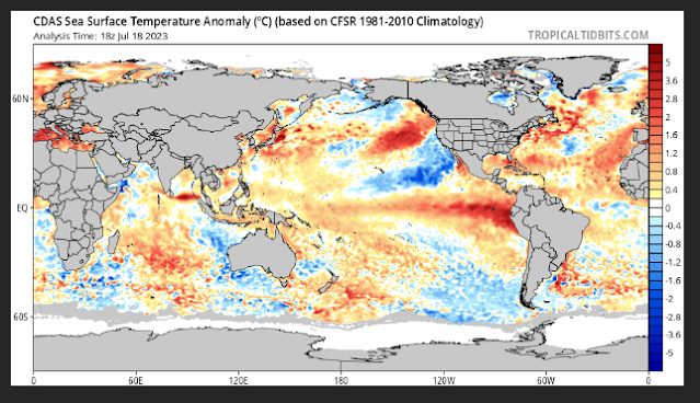
Figure 1: Current SST anomalies
The Indian however has started to make some small moves towards a positive IOD. It still has a long way to go but in the last couple of weeks we have seen some cooling off the NW coast of WA and near Java with warming closer to the horn of Africa. The index was measured at –0.12C in neutral bounds however eyeballing the structure of the anomalies, I think it is already into positive ranges now (but not positive IOD thresholds of +0.4C). A weak to moderate event looks likely with that making a better move through later August and September before the entire Indian basin warms to become quite hot indeed later in the year and summer time. We need to watch the strength of high pressure across Australia which will in turn shove some easterly winds across the Eastern IOD box and assist in that colder water to slowly upwell off the coast of Java and Sumatra, but I stress this will be a slow process.
The SAM is currently slightly negative with large and active lows over the Southern Ocean but due to the zonal flow, which was discussed in the previous outlook, the actual impacts further north have been limited with a real lack of SW-NE punch of colder air, instead it keeps travelling steadily below us with fronts only clipping the coastline. I expect with increasingly stronger high pressure to round out July that we will see the index get positive before pushing back to neutral levels.
Now the MJO is largely irrelevant for moisture at this time of the year however the Westerly Wind Bursts (WWB’s) are important to help trigger El Nino. Currently it is in phase 6 and moving towards phase 7 at a weak to moderate strength which will just be enough to reduce trade winds a little and keep the overall formation of El Nino ticking along – it is just quite slow at the moment.
Districts:
Eyre Peninsula
Cold front due early 20th with a broken band of showers. Colder air to follow the front in a fresh W to SW airstream with scattered showers about Lower Eyre Peninsula. All shower activity more isolated with northern and NE extent, especially by mid-afternoon. Weak ridge 21st, with perhaps a light shower or two near the tip of the Peninsula before a stronger front moves in from the SW early on 22nd before dawn with a band of showers. Colder air in blustery SW-S flow behind the front with further scattered showers but becoming isolated by the evening. Isolated stream showers running up the Spencer Gulf into Eastern Eyre Pen overnight into 23rd. New strong high moving in from the west from 24th with isolated light showers clearing during the day before generally fine conditions settle in. Slight frost risk 24th-26th. Further series of frontal systems likely from about 27th or 28th with freshening N winds beforehand. Showery periods to follow, chiefly across the Central to Southern portions of the Peninsula. Rainfall for remainder of month 7-15mm, with isolated 20-25mm falls about Lower Eyre Peninsula. Totals decreasing towards N/NE Eyre Peninsula down to 3-7mm.
Upper North
Weakening cold front due mid-morning on 20th with a broken band of fairly isolated showers but not a lot in it. Colder air to follow the front in a fresh W to SW airstream with isolated showers before they largely clear by the evening. Weak ridge 21st, with perhaps a light shower lingering before a stronger front moves in from the SW late morning on 22nd with a band of showers. Colder air in blustery SW-S flow behind the front with further scattered showers but becoming isolated by the evening. Isolated evening stream showers running up the Spencer Gulf into the Melrose area and surrounds. New strong high moving in from the west from 24th with isolated light showers clearing during the day before generally fine conditions settle in. Slight frost risk 24th-26th. Further series of frontal systems likely from about 27th or 28th with freshening N winds beforehand. Showery periods to follow, chiefly across the southern half of the district. Rainfall for remainder of month 5-10mm, with isolated 15mm falls in the south and about higher terrain. Totals decreasing off back side of ranges and into Flinders to a mere 1-3mm.
Lower North
Weakening cold front due mid-morning on 20th with a broken band of showers but not a lot in it. Colder air to follow the front in a fresh W to SW airstream with isolated showers before they largely clear by the evening. Weak ridge 21st, with perhaps a light shower lingering before a stronger front moves in from the SW late morning on 22nd with a band of showers. Colder air in blustery SW-S flow behind the front with further scattered showers before becoming isolated by the evening. New strong high moving in from the west from 24th with isolated light showers clearing during the day before generally fine conditions settle in. Slight frost risk 24th-26th. Further series of frontal systems likely from about 27th or 28th with freshening N winds beforehand. Showery periods to follow in a fresh NW-SW flow. Rainfall for remainder of month 7-15mm, with isolated 20mm falls about higher terrain. Totals decreasing off back side of ranges to 3-5mm.
Yorke Peninsula
Cold front due early 20th with a broken band of showers, chiefly near the foot. Colder air to follow the front in a fresh W to SW airstream with scattered showers, again chiefly about the foot. All shower activity more isolated with northern extent, especially by mid-afternoon. Weak ridge 21st, with perhaps a light shower or two near the foot before a stronger front moves in from the SW from early to mid-morning on 22nd with a band of showers. Colder air in blustery SW-S flow behind the front with further scattered showers but becoming isolated by the evening. Isolated stream showers running up the gulfs either side during the evening with perhaps a focus into the Hummocks in the moist southerly for a few hrs. New strong high moving in from the west from 24th with isolated light showers clearing during the day before generally fine conditions settle in. Slight frost risk in far north 24th-26th. Further series of frontal systems likely from about 27th or 28th with freshening N winds beforehand. Showery periods to follow, chiefly across the Central portions and southern/foot of the Peninsula. Rainfall for remainder of month 10-15mm, with isolated 20mm falls about the foot. Totals decreasing towards N down to about 5-10mm.
Kangaroo Island
Cold front due early 20th with broken band of showers with possibly a brief isolated thunderstorm. Colder air to follow the front in a fresh W to SW airstream with scattered showers. All shower activity becoming isolated by evening. Weak ridge 21st, with perhaps a light shower or two lingering before a stronger front moves in from the SW near dawn on 22nd with multiple bands of showers. Colder air in blustery SW-S flow behind the front with further scattered showers but becoming isolated by the late evening. Possible small hail and local cold air thunder. New strong high moving in from the west from 24th with isolated light showers clearing during the day before generally fine conditions settle in. Slight frost risk in centre of island 25th-26th. Further series of frontal systems likely from about 27th or 28th with freshening N winds beforehand. Showery periods to follow with possible isolated thunderstorms. Rainfall for remainder of month 25-35mm, with isolated 40-45mm falls about the western end. Totals decreasing towards E end down to about 15-25mm.
Adelaide Plains
Cold front due early 20th with a broken band of showers. Colder air to follow the front in a fresh W to SW airstream with scattered showers, chiefly towards the Southern suburbs. All shower activity more isolated with northern extent, especially by mid-afternoon. Weak ridge 21st, with perhaps a light shower or two before a stronger front moves in from the SW mid to late morning on 22nd with a band of showers. Colder air in blustery SW-S flow behind the front with further scattered showers but becoming isolated by the evening. Isolated stream showers running up the gulf during the evening where the outer NW Plains may see some lingering showers. New strong high moving in from the west from 24th with isolated light showers clearing during the day before generally fine conditions settle in. Slight frost risk about far northern outer plains 24th-26th. Further series of frontal systems likely from about 27th or 28th with freshening N winds beforehand. Showery periods to follow, chiefly across the areas south of the outer northern plains. Rainfall for remainder of month 12-18mm, with isolated 20mm falls possible near foothills. Totals decreasing towards N down to about 5-10mm.
Mt.Lofty Ranges
Cold front due early 20th with a broken band of showers. Colder air to follow the front in a fresh W to SW airstream with scattered showers, chiefly south of the Barossa. All shower activity more isolated with northern extent, especially by mid-afternoon. Weak ridge 21st, with perhaps a light shower or two before a stronger front moves in from the SW mid to late morning on 22nd with a band of showers. Colder air in blustery SW-S flow behind the front with further scattered showers but becoming isolated by the evening and generally contracting to the southern coasts and ranges. New strong high moving in from the west from 24th with isolated light showers clearing during the day before generally fine conditions settle in. Slight frost risk about low lying valleys 24th-26th. Further series of frontal systems likely from about 27th or 28th with freshening N winds beforehand. Showery periods to follow, chiefly across the areas south of the Barossa. Rainfall for remainder of month 15-25mm, with isolated 40mm falls possible near known wet spots. Totals decreasing towards back side of ranges down to 5-15mm.
Riverland/Mallee
Weakening cold front due mid-morning on 20th with a broken band of fairly isolated showers but not a lot in it, mostly just for the Mallee. Colder air to follow the front in a fresh W to SW airstream with isolated showers before they largely clear by the evening. Weak ridge 21st, with perhaps a light shower lingering before a stronger front moves in from the SW from late morning to early afternoon (for the Riverland) on 22nd with a band of showers. Colder air in blustery SW-S flow behind the front with further scattered showers but becoming isolated by the evening, although some wrap around drizzly showers and streams may roll up from the south overnight into early 23rd as upper low forms to NE. New strong high moving in from the west from 24th with isolated light showers clearing during the day before generally fine conditions settle in. Slight to moderate frost risk 24th-26th, chiefly for the Riverland. Further series of frontal systems likely from about 27th or 28th with freshening N winds beforehand. Showery periods to follow, chiefly over the southern half of the Mallee with activity more isolated with northern extent. Rainfall for remainder of month 5-10mm about the Mallee with isolated 15mm falls possibly in the far south/SW. Totals decreasing towards Riverland down to around 2-5mm.
Upper SE
Weakening cold front due mid-morning on 20th with a broken band of showers. Colder air to follow the front in a fresh W to SW airstream with isolated showers before they largely clear by the evening. Weak ridge 21st, with perhaps a light shower lingering before a stronger front moves in from the SW from late morning to early afternoon on 22nd with a band of showers. Colder air in blustery SW-S flow behind the front with further scattered showers but becoming isolated by the evening, although some wrap around drizzly showers and streams may roll up from the south overnight into early 23rd as upper low forms to NE. New strong high moving in from the west from 24th with isolated light showers clearing during the day before generally fine conditions settle in. Slight frost risk 24th-26th. Further series of frontal systems likely from about 27th or 28th with freshening N winds beforehand. Showery periods to follow. Rainfall for remainder of month 7-15mm with isolated 20mm falls possible in the far south. Totals decreasing towards the NE down to around 5-7mm.
Lower SE
Weakening cold front due mid-morning on 20th with a broken band of showers. Colder air to follow the front in a fresh W to SW airstream with isolated showers before they largely clear by the evening. Weak ridge 21st, with perhaps a light shower lingering before a stronger front moves in from the SW from late morning to early afternoon on 22nd with a band of showers. Colder air in blustery SW-S flow behind the front with further scattered showers but becoming isolated by the evening. New strong high moving in from the west from 24th with isolated light showers clearing during the day before generally fine conditions settle in. Slight frost risk 24th-26th. Further series of frontal systems likely from about 27th or 28th with freshening N winds beforehand. Showery periods to follow. Rainfall for remainder of month 12-25mm with isolated 30mm falls possible in the far south. Totals decreasing towards the NE down to around 10-12mm.
Western VIC
Weakening cold front due late morning on 20th with a broken band of showers but not a lot in it. Colder air to follow the front in a fresh W to SW airstream with isolated showers before they largely clear by the evening. Weak ridge 21st, with perhaps a light shower lingering before a front over SA on 22nd weakens bringing some showers to the western border areas. Colder air in blustery SW-S flow behind the front with upper low to N with showers lingering in moist southerly flow through 23rd. New strong high moving in from the west from 24th with isolated light showers clearing during the day before generally fine conditions settle in. Slight frost risk 25th-27th. Further series of frontal systems likely from about 28th or 29th with freshening N winds beforehand. Showery periods to follow, chiefly about the SW District with more isolated activity north of here. Rainfall for remainder of month 10-18mm about the SW District tending to 7-10mm about the Wimmera and down to 2-5mm about the Mallee. Isolated 20-25mm falls possible in far SW of SW District.
Final Notes
El Nino more advanced in formation than positive IOD but both will get up, the IOD being weak to moderate with El Nino moderate.
Frosty periods will continue under large highs through late July although not as cold as the recent multi-day event
August will see wetter conditions than July with mix of fronts and highs and attempted moisture infeeds before going drier again in September with warmth rapidly increasing.
Longer term outlook for remainder of Spring is drier than average conditions before moisture starts to push back towards December a little with near average rainfall
Given El Nino will develop, the leftover heat in Oceans will fuel an increase in rainfall for 2024
Link to temporary blog website: https://farmweathersa.blogspot.com/
Happy Farming and Cheers from The Weatherman
*Note – For interest only, all thoughts are of The Weatherman and may not be reproduced without my consent.


Comments
Post a Comment