April 2023 Outlook SA
April 2023 outlook SA
*Forecast prepared between April 1st-3rd 2023
Review:
G’Day everyone, and here we are in April! The season is moving along quite quickly now as we approach the start of the business period of the year for many of you, a crucial time in forecast outlooks is upon us.
The back portion of March has seen that expected uptick in activity and rainfall potential with a handy system moving through on the 26th and 27th delivering areas of rain and isolated thunderstorms. A secondary upper low which was mentioned in the March update really stalled and slowed down in the Bight and lagged back west enough to allow afternoon thunderstorms to erupt east of the ranges on the 27th with some localised heavy totals across both the Mallee and Riverland. There were also some reports of hail in the stronger cores, one near Wynarka and also another strong core a little further NE into the Mallee. A 32mm report from those thunderstorms with hail came from somewhere east of Wynarka iirc.
Beyond this we saw some weak confluence into streams with cool to cold upper levels allowing showers to form with ease at times in a moist SW to S flow for the most part with some handy 2-8mm totals across the southern agricultural area.
Much further inland across the NW Pastoral we saw some areas of rain from persist mid-level cloud feeding in off of the Indian Ocean along a moist mid to upper level jetstream where the flow aloft was squeezed. Totals in the order of 5-15mm were the main feature here but nothing significant as the rain was mostly stratiform with only the odd isolated thunderstorm.
So, looking back to the March outlook, given I was late with it, I won’t do a cut and paste comparison, but the expectation was around average conditions with that later uptick in moisture. Here are the charts in any case:

Now looking above at the deciles, we can see that there was no dominant wet or dry pattern for the month. Taking the Adelaide monthly rainfall as an example, the month started off with a small wet period from 5th-9th before going dry right through till the 26th where rain and shower activity lingered through till the end of the month. The net result is close to average rainfall but with a trend to slightly above average rainfall for portions of the agricultural areas, in particular the Northern Eyre Peninsula to Southern NW Pastoral and pockets of the Yorke Peninsula both northern and near the foot where thunderstorm activity contributed to much of this and we can see this particularly well in the rainfall percentages in Figure 2 Much further north across the greater Pastoral areas we did see generally below average conditions with a lack of significant infeeds until right near the end however the resultant precipitation from this was not enough to arrest the below average results.


Meteorological Discussion:
Now comes the time to discuss the all-important forecasts, outlooks and expected conditions over both this month and the next few after that and certainly at this stage, I see no changes bar as slight shift in timeline of the previous outlooks issued since December. So far this year, we have seen a fairly lacklustre effort from the tropics with only one main heavy rain and flooding effort focused over W and NW QLD and into the adjacent Eastern NT. Significant slow-moving floodwater is currently moving through the tributaries towards Lake Eyre North with some spectacular sights and bird life filling normally dry inland areas. I expect Lake Eyre North to fill to around 30-40% once all this ends up there, given there is a tiny bit of water in it already.
More recently a strong surge of moisture has caused heavy inland rain into WA with areas of flooding but a lot of this struggled to marry up with strong frontal systems and generate good rainfall across SA, only patchy areas with isolated good falls – inconsistent and unreliable type of rainfall.
In the last March update sent out I mentioned that this up and coming little burst of moisture with 2 systems will not be a breaking rain and despite multiple weaker fronts pushing up after a weak cut off low in the coming week, I still maintain that it is not a break in the season, maybe for some it may seem like it with good moisture reserves but a false break for the majority as we will go dry again and with downwelling (sinking air from the upper levels caused by the expanding Hadley cell), I am sure frustrations may start to grow by the time we are in late May with patchy systems expected for the most part. I do expect some NW cloudband activity, but most totals will be fairly light across both April and May.
Currently we have the remnants of Tropical Cyclone Herman off the NW coast of Australia with it being so weak now that there is only low cloud around the centre. More convection is located closer to the coast NW of Port Hedland, and this is all part of the approaching MJO and our source of moisture for the next 7-10 days at best before things shift further east with the NW moisture supply becoming more sparse.
A weak cut off low is expected to develop in the Bight on the 5th before gradually moving eastwards and weakening through the 6th and 7th. Scattered showers and isolated thunderstorms will develop across the Far West of the state on the 4th, chiefly during the afternoon and evening with the possibility of some severe thunderstorms. This activity will spread to more general areas of rain and embedded thunderstorms later in the evening again over the Far West before weakening into the 5th as it moves eastwards across the interior of the NW Pastoral.
Now along the troughline subtending NNE out of the cut off low over the Bight we should see isolated mid-level showers and thunderstorms, mostly over the West Coast and adjacent Pastoral areas, reaching the Eyre Peninsula during the afternoon and the Adelaide area sometime in the evening. Due to the weakening trend, I wouldn’t be expecting much rainfall from this troughline.
Renewed afternoon thunderstorms will erupt further NW in the same areas that received rain the prior evening due to higher low level moisture loading. These will primarily be diurnally driven so without the dynamic forcing aloft, they will peter out after dark.
A cold front will then develop across the Bight out of the low during the evening of the 5th and move E/SE sliding as it does so. There should be a bit more cold air aloft for this front to work with and better surface convergence so I would expect more scattered showers and isolated thunderstorms than along the troughline with this activity reaching Eyre Peninsula in the pre-dawn hours and then Adelaide roughly by mid-morning. Mid-level thunderstorm activity also may develop behind the trough and ahead of the cold front in the warm air before dawn, enhanced by a weak low level nocturnal jetstream across the southern agricultural areas but not a great deal of precipitation once again.
Further west the main low centre should be slinging around with a new trough to form along this driving blustery showers and windy conditions across the coasts and adjacent southern agricultural areas. This trough should impact the West Coast of Eyre Peninsula from mid-afternoon on the 6th and into the Adelaide region during the early evening and east of the ranges through mid-evening at this stage. There may be an isolated thunderstorm on the very leading edge of this little wrap around band, especially with the timing being later in the day.
On Good Friday we should see the low drop down and connect to the westerly belt to the east of us which will allow a deeper and longer fetched SW flow with embedded weak troughs to be directed into the state with cool to cold conditions in that fresh SW flow. Stream showers will begin to setup here, with localised streams forming from both gulfs into the Lower and Upper North, Yorke Peninsula, and parts of both the Adelaide Plains and Mt.Lofty Ranges although most of this will be a mix of light to moderate showers, thus no huge totals are expected. Nevertheless, for those areas being impacted by such training streams, we could see 10-15mm extra from those. Not the best for the grape growers however but, it certainly could be worse.
On Sat the 8th a weak trough will move in from the SW with a spate of showers, reaching Adelaide by mid-morning but these will becoming isolated from the SW during the later afternoon.
A final weak trough (weaker than Saturdays) quickly slides up from the SW/S early Sunday 9th with further light showers in a cool, moist onshore airstream. Most of this will clear all but the most coastal areas by Monday 10th as a fairly strong high pressure system muscles in from the Bight.
Now a fairly strong Tropical Cyclone should be developing out of the MJO pulse from about the 11th and this should move SW off the WA coastline before a longwave trough grabs it and brings it ashore, potentially somewhere from Port Hedland to Exmouth – a traditional area. All indications are that it will be at least category 4 if not a 5. Unfortunately for those looking for rain (not everyone!) I think the associated trough and cold front will be moving a bit too quickly to make the most of the large quantities of tropical moisture residing within the TC resulting in a less substantial NW cloudband/rainband feeding in from it before a pinch off occurs somewhere over central to eastern SA. But this is a long way off at this stage with the rain and associated fast moving trough/front due into the agricultural areas on approximately the 12-14thth. If the TC is slow enough, then there may be some moisture remaining for a secondary trough or front to capture up to 5 days after so this will need to be watched at least.
Beyond this we will likely see another period of ridging take hold over the Tasman in the second half of the month with some fast moving but sliding cold fronts.
Now to the all-important rainfall outlook for April. With the wetter window for the first half and drier for the second I think broadly we are looking at average to slightly below average for the agricultural areas. The greatest chance of popping above the average will be over the West Coast/Far West of the state, NW corner and potentially the southern coastlines of EP, YP, most of KI and the coast of the Lower SE. The NW/W of the state especially sees the greatest chances. As we move east and north however across the agricultural areas towards the Upper North and indeed the NE Pastoral, the odds of below average rainfall increase. The NE corner will have the greatest chances of below average to well below average rainfall.
Climate Drivers
The Pacific Ocean has shown continual signs of moving away from La Nina and setting up for an El Nino like pattern. A lot of progress has been made on this in the last couple of months and moreso the last 3-4 weeks, in particular the far eastern portions of the Pacific where you can see in Figure 4 the complete collapse of the Humboldt Current off Peru, now replaced with vasty above average anomalies. But we have still got some work to do yet. A significant change in the sub surface structure will allow the final portions of the warmer water that is over the Western sub-surface to move up to the surface over the Central and Eastern Pacific. There is a potential for an El Nino Modoki like structure in the central Pacific by the end of the season. I hope that at least makes some sort of sense! Please see Figure 5 for a better representation of what we are looking at in the sub surface and whilst there is a little cool water there still, it is shrinking.


Now for the Indian, we are soon going to moving into the time where it becomes important for us, April through till late spring is the time (especially later winter to spring). Currently we have some wiggle room with warmth off the NW coast and this combined with a well-timed strong MJO and instability in the jetstreams is causing a lot of moisture to feed into the mainland, with tremendous falls across inland parts of WA. Further west of these warmer anomalies are some cooler ones and then we get warmer again as we close on the East African coastline. It will take a while to sort itself out, but I see a slow decline in the warmth off the NW coast over the coming 2-3months with warming in the west. A classical (albeit not strong) signature of colder upwelling off Sumatra and Java will then begin later in winter to spring to form a weak to moderate positive IOD. The consistent stronger SE trades off mainland Australia caused by more high pressure will allow for this to develop. However, it won’t be to the standard of strong historical positive IOD’s like 1994, 2006 and 2019. In the coming month or two I will try to pick a year that feels similar to this one, but at this stage 2002 does seem reasonable enough.
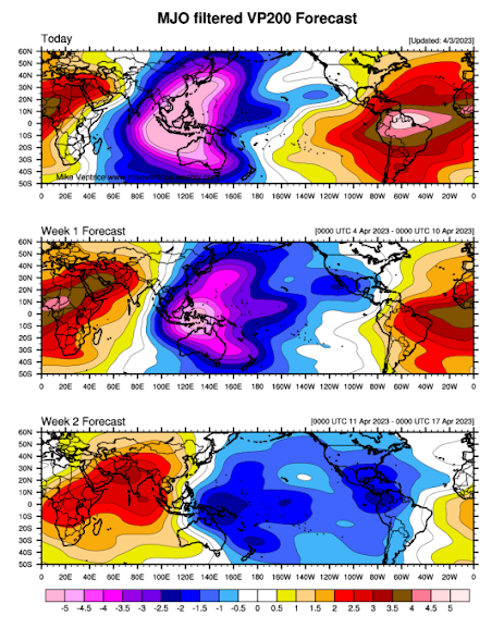
Moving on to the MJO and it is clear that this current pulse is the strongest of the entire season, with a powerful upward motion area off the NW coast of Australia. The satellite is littered with strong Tropical convection and a few days ago gave birth to Tropical Cyclone Herman (which did reach category 5 status well offshore from the NW coast of WA before getting torn apart by shear.)
The MJO is currently in phase 3 and almost to phase 4 (just off the NW coast of Australia). In the coming week it will progress steadily eastwards at a strong strength before weakening slowly in the Pacific. I do expect however there to be enough punch in the westerly component of this strong MJO to make another large dent in the decaying La Nina and push us closer to an El Nino like setup. The rainfall potential from the NW will remain good till about 10 days into April, after which it will dry up with only frontal systems being the potential source of rainfall after that for quite some time as we enter our expected drier period.
The SAM is neutral at the moment, after a brief burst to positive values mid-month. I do expect a push of cold fronts after the MJO moves well into the Pacific but most moisture sourced with be from the Southern Ocean only. Neutral to slightly negative values are expected in the near term before a rise to positive values through the latter part of the month as high pressure begins to take hold a little more than it currently is.
Districts:
Eyre Peninsula
Cut off low developing in Bight on 5th with isolated showers and thunderstorms extending from the west but not a lot in it. Cold front due early on 6th with another weakening band of scattered showers and isolated thunderstorms before the low centre curls up with a secondary faster moving trough in the afternoon bringing blustery conditions with more frequent showers and perhaps and isolated thunderstorm about the Lower Eyre Peninsula. Low moves east and weakens with a large high ridging in from the west. A weak trough will bring onshore showers on 7th, chiefly to the Lower Eyre Peninsula with a cold front on the 8th bringing a spate of showers. Finally, yet another weak trough on 9th will keep moist onshore flow with isolated showers, chiefly about the Lower Eyre Peninsula. All shower activity will be more isolated inland with much lower totals. Large high due till about 12th ahead of fast-moving trough and cold front, potentially with a weak band of rain. Rainfall for the period (2 weeks) in the order of 5-8mm generally across the Peninsula. Local totals to 20mm about Lower EP grading to 2-5mm much further N and NE towards the Pastoral zone.
Upper North
Cut off low developing in Bight on 5th with isolated mid-level showers extending from the west late evening but not a lot in it. Isolated mid-level showers and thunderstorms developing in the early hours ahead of a cold front due during mid-morning on 6th with another weakening band of scattered showers before the low centre curls up with a secondary faster moving trough in the evening bringing blustery conditions with scattered showers, more isolated north of about Jamestown. Low moves east and weakens with a large high ridging in from the west. A weak trough will bring an onshore flow with isolated showers on 7th, chiefly in the south with a cold front on the 8th bringing a spate of showers and potentially allowing some localised streams off the Spencer Gulf briefly. Finally, yet another weak trough on 9th will keep moist onshore flow however only isolated light showers in the south. All shower activity will be a lot more isolated north of about Port Augusta with much lower totals. Large high due till about 12th ahead of fast-moving trough and cold front, potentially with a weak band of rain. Rainfall for the period (2 weeks) in the order of 4-6mm generally however scattered totals to 10mm and isolated 20-25mm falls in repeat streams are possible and near higher terrain. North of Port Augusta and east of the ranges totals will be less than 4mm.
Lower North
Cut off low developing in Bight on 5th with isolated mid-level showers extending from the west late evening but not a lot in it. Isolated mid-level showers and thunderstorms developing in the early hours ahead of a cold front due during mid-morning on 6th with another weakening band of scattered showers before the low centre curls up with a secondary faster moving trough in the evening bringing blustery conditions with scattered showers though a little more isolated in the far north and east. Low moves east and weakens with a large high ridging in from the west. A weak trough will bring an onshore flow with isolated to scattered showers on 7th, chiefly in the south with a cold front on the 8th bringing a spate of showers and potentially allowing some localised streams off the gulfs briefly. Finally, yet another weak trough on 9th will keep moist onshore flow however only isolated light showers are expected. Large high due till about 12th ahead of fast-moving trough and cold front, potentially with a weak band of rain. Rainfall for the period (2 weeks) in the order of 7-12mm generally however scattered totals to 15mm and isolated 20-25mm falls in repeat streams are possible and near higher terrain. East of the ranges totals will drop off to about 4-7mm.
Yorke Peninsula
Cut off low developing in Bight on 5th with isolated showers and thunderstorms extending from the west later but not a lot in it. Early morning isolated mid-level showers and thunderstorms developing ahead of a cold front due early on 6th with another weakening band of scattered showers and isolated thunderstorms before the low centre curls up with a secondary faster moving trough in the late afternoon (early evening in the N) bringing blustery conditions with more frequent showers and perhaps and isolated thunderstorm about the foot of the Peninsula. Low moves east and weakens with a large high ridging in from the west. A weak trough will bring onshore showers on 7th, with a cold front on the 8th bringing a spate of showers. Finally, yet another weak trough on 9th will keep moist onshore flow with isolated showers, chiefly about the foot. Large high due till about 12th ahead of fast-moving trough and cold front, potentially with a weak band of rain. Rainfall for the period (2 weeks) in the order of 7-10mm generally across the Peninsula. Local totals to 20-25mm about the foot grading to 4-7mm over the N of the Peninsula.
Kangaroo Island
Cut off low developing in Bight on 5th with isolated showers and thunderstorms extending from the west later but not a lot in it. Early morning isolated mid-level showers and thunderstorms developing ahead of a cold front due early on 6th with another weakening band of scattered showers and isolated thunderstorms before the low centre curls up with a secondary faster moving trough in the late afternoon bringing blustery conditions with more frequent showers and perhaps and isolated thunderstorm on the leading edge. Low moves east and weakens with a large high ridging in from the west. A weak trough will bring onshore showers on 7th, with a cold front on the 8th bringing a spate of showers and cold SW winds. Finally, yet another weak trough on 9th will keep moist onshore flow with isolated showers. Large high due till about 12th ahead of fast-moving trough and cold front, potentially with a weak band of rain. Rainfall for the period (2 weeks) in the order of 8-15mm. Local totals to 20-25mm about the western end of the island grading to 6-8mm in the east.
Adelaide Plains
Cut off low developing in Bight on 5th with isolated showers extending from the west late evening but not a lot in it. Early morning isolated mid-level showers and thunderstorms developing ahead of a cold front due early on 6th with another weakening band of scattered showers and isolated thunderstorms before the low centre curls up with a secondary faster moving trough in the early evening bringing blustery conditions with more frequent showers and perhaps and isolated thunderstorm on the leading edge. Low moves east and weakens with a large high ridging in from the west. A weak trough will bring onshore showers on 7th, with streams setting up potentially across the N plains. A cold front on the 8th bringing a spate of showers. Finally, yet another weak trough on 9th will keep moist onshore flow with isolated showers, chiefly about the southern suburbs. Large high due till about 12th ahead of fast-moving trough and cold front, potentially with a weak band of rain. Rainfall for the period (2 weeks) in the order of 8-15mm Local totals to 20-25mm about the foothills grading to 6-8mm towards the Western suburbs.
Mt.Lofty Ranges
Cut off low developing in Bight on 5th with isolated showers extending from the west late evening but not a lot in it. Early morning isolated mid-level showers and thunderstorms developing ahead of a cold front due early on 6th with another weakening band of scattered showers and isolated thunderstorms before the low centre curls up with a secondary faster moving trough in the early evening bringing blustery conditions with more frequent showers, heavy at times with orographic lift
and perhaps and isolated thunderstorm on the leading edge. Low moves east and weakens with a large high ridging in from the west. A weak trough will bring onshore showers on 7th, with streams setting up to the north. A cold front on the 8th bringing a spate of showers. Finally, yet another weak trough on 9th will keep moist onshore flow with isolated showers, chiefly about the southern coasts and ranges. Large high due till about 12th ahead of fast-moving trough and cold front, potentially with a weak band of rain. Rainfall for the period (2 weeks) in the order of 12-25mm Local totals to 40mm about the higher peaks and known wet spots grading to 8-12mm towards the back of the ranges.
Riverland/Mallee
Cut off low developing in Bight on 5th with isolated mid-level showers in the west early on 6th. Isolated mid-level showers and thunderstorms re-developing in the early hours ahead of a near decayed cold front due during the late afternoon on 6th, but only isolated showers are expected here. Main low centre curls up with a secondary faster moving trough in the evening bringing blustery conditions with scattered showers, a little more consistent over the southern parts of the Mallee but more isolated over the Riverland. Slight possibility of a thunderstorm on the leading edge. Low moves east and weakens with a large high ridging in from the west. A weak trough will bring an onshore flow with isolated to scattered drizzly showers on 7th, chiefly in the south of the Mallee with a cold front on the 8th bringing a spate of showers, more isolated over the Riverland once more. Finally, yet another weak trough on 9th will keep moist onshore flow however only isolated light showers in the south/SW of the Mallee. All shower activity will be a lot more isolated over the eastern and northern Riverland. Large high due till about 12th ahead of fast-moving trough and cold front, potentially with a weak band of rain. Rainfall for the period (2 weeks) in the order of 4-8mm generally across the Mallee however scattered totals to 10mm and isolated 12mm falls in the far S/SW. Riverland will see 2-5mm falls generally.
Upper SE
Cut off low developing in Bight on 5th with isolated mid-level showers in the west/near Coorong coast early on 6th. Isolated mid-level showers and thunderstorms re-developing in the mid-morning ahead of a near decayed/washed out cold front due during the late afternoon on 6th. Main low centre curls up with a secondary faster moving trough in the evening bringing blustery conditions with a band of showers. Slight possibility of a thunderstorm on the leading edge. Low moves east and weakens with a large high ridging in from the west. A weak trough will bring an onshore flow with isolated to scattered drizzly showers on 7th, with a cold front on the 8th bringing a spate of showers, easing later. Finally, yet another weak trough on 9th will keep moist onshore flow however only isolated light showers, chiefly coastal. Large high due till about 12th ahead of fast-moving trough and cold front, potentially with a weak band of rain. Rainfall for the period (2 weeks) in the order of 5-10mm generally however localised totals to 15mm about the coast are possible. Lighter totals from 4-6mm are likely closer to the Victorian border.
Lower SE
Cut off low developing in Bight on 5th with isolated mid-level showers in the west coast early on 6th. Isolated mid-level showers and thunderstorms re-developing in the mid to late morning ahead of a near decayed/washed out cold front due during the late afternoon on 6th. Main low centre curls up mainly to the north of the district at this stage and hence winds will be a little lighter than districts further north A band of showers, more isolated in the south will accompany a weak trough here. Low moves east and weakens with a large high ridging in from the west. A weak trough will bring an onshore flow with colder winds and scattered drizzly showers on 7th, with a cold front on the 8th bringing a spate of heavier showers, easing later, but cold conditions extending throughout in a blustery SW flow. Finally, yet another weak trough on 9th will keep moist onshore flow however only isolated light showers. Large high due till about 12th ahead of fast-moving trough and cold front, potentially with a weak band of rain. Rainfall for the period (2 weeks) in the order of 5-10mm generally however localised totals to 15-20mm about the coast are possible. Lighter totals from 4-6mm are likely closer to the Victorian border or in the far N.
Western VIC
Cut off low developing in Bight on 5th with isolated mid-level showers early on 6th. Isolated mid-level showers and thunderstorms re-developing throughout the day ahead of a near decayed/washed out cold front due during the late afternoon/evening on 6th. Trough around lead edge of low centre will bring a general band of showers, chiefly to Wimmera and northern portions of the SW District late 6th and early hrs of 7th. Low moves east and weakens with a large high ridging in from the west. A weak trough will bring an onshore flow with colder winds and scattered drizzly showers on 7th, with a cold front on the 8th bringing a spate of heavier showers, easing later, but cold conditions extending throughout in a blustery SW flow. Finally, yet another weak trough on 9th will keep moist onshore flow however only isolated light showers. Large high due till about 12th ahead of fast-moving trough and cold front, potentially with a weak band of rain. Rainfall for the period (2 weeks) in the order of 4-6mmover the Mallee, 8-15mm over the Wimmera and 10-20mm over the SW District however higher totals to 30mm are likely closer to the coast and SE portions of the district.
Final Notes:
- El Nino and positive IOD of weak to moderate strength looking more and more likely with every run leading to broadly below average rainfall from April to September however not to the poor levels of 1994, 2006, 2015 & 2019
- Increase in frost compared to 2022
- Last rinse of tropics in the coming 7-10 days after which MJO moves away and downwelling takes hold
- Frontal action will be main source of rainfall through winter and spring with limited infeeds
- If expected Tropical Cyclone next week recurves sooner, expect greater chance of rainfall coming through NW SA and into a cold front, will watch closely
- Spring outlook is for a continuation of below average rainfall, with more wind than usual and fast moving ‘dry’ troughs and cold fronts plus an increased risk of high based thunderstorms
- Best rainfall months at this stage will either be June or August but neither stand out at this stage.
Link to temporary blog website: https://farmweathersa.blogspot.com/
Happy Farming and Cheers from The Weatherman
*Note – For interest only, all thoughts are of The Weatherman and may not be reproduced without my consent.


Comments
Post a Comment