March 2023 update SA
March 2023 update SA
Forecast prepared between March 21-23rd 2023
Review:
G’Day everyone, quick little update as we approach the later parts of the month now. Not a huge amount has been going on in terms of rainfall across out state this month so far but certainly the pattern has been fluid with constant changes from warm to cool, to windy to calm. A notable event recently was the severe gully wind/downslope events on the morning of March 20th with a focus around the eastern suburbs and foothills of Adelaide. This occurred as a strong ridge moved in rapidly from the west whilst a trough was deepening further NE really tightening the gradient. The cooling effect and sinking air funneling through the gullies did the rest with near calm conditions only a few km further west at times whilst 90-110km/hr winds ripped through the Eastern/NE and parts of the southern suburbs. Just after this an upper-level trough was able to induce some patchy rain areas and isolated thunderstorms on the 21st but rainfall totals were mostly under 2mm. A lot of heat was present further north with numerous centres reaching into the low 40’s but this is not unusual for March.
Much further north, massive flooding rains have occurred over far Western QLD and NW QLD and into Eastern NT. This was expected and had been mentioned in previous forecasts. Burketown was quite badly flooded as well as numerous areas of the upper Channel Country and Gulf Country. A lot of this floodwater will work into Lake Eyre North in the coming months and also other large salt lakes through the Channel Country. It could be quite a sight once the maximum water level has been reached.
Meteorological Discussion:
The remainder of the month will see the greatest chance of some rainfall across the state with the combination of MJO, SAM and lingering jetstream meandering combining to form a meridional pattern mixing warm and cold. Moisture is building off NW WA ahead of the MJO pulse and with the interior being under the influence of upper ridging, we should see a tight gradient aloft emerge off WA.
The current situation sees a lot of upper trough activity through the Australian region. A weak one waffled through the southern parts of SA overnight (22nd) and has now erupted a series of thunderstorms across VIC today with only a weak surface trough for assistance but moisture from NSW and the Tasman is sufficient enough. The tropics are seeing a general increase in moisture off the NW coast of WA, and this is indeed setting up to at least give us a bit of a shot at getting some moisture infeed/NW Cloudband like system(s) into the state before we go dry again. It is only a temporary window whilst we have the MJO, SAM, remaining monsoonal moisture and meandering jetstreams providing the upper cold air and ascent/lift all combined to give us at least something to open the season but I do stress it is not a break in the season into winter. Fortunately, we have some reasonable moisture down deep in many parts of the state rather than coming off a bad year last year so there is wiggle room, but it will all be needed by the time winter comes around. The main source of moisture for the next system at least will be from a slow moving weak tropical low located off the NW coast of WA. The slow-moving nature of this low will allow a reasonable amount of moisture to flow down through WA into a broad low-pressure trough. Areas of rain, showers and isolated thunderstorms will occur but increase when an upper trough stands up and approaches from the west, squeezing the jetstream gradient aloft and really bringing that moisture down through the mid and upper levels from the 25th and into the 26th.
For those in WA, there are likely to be some good to very good falls, some heavy with potential for inland flooding much further north into parts of the Pilbara (somewhere say Port Hedland and south a few hundred km) But cropping zones for the most part should get a good drink, patchy towards the Perth side however as the main connection channels down well inland along the jetstream. The Esperance region and surrounding inland areas should receive a welcome early season rain with a little extra from around the back side of the upper trough as it moves through along the southern coastal portions of WA. The tricky bit is further east as it all moves into SA, it does lose a lot of the initial lift as the main trigger, the upper trough weakens and flattens back out below WA. There will however be areas of rain, forming into a mostly general band of rain at times through coming in quite low down and coastal along the jetstream on the 26th before a secondary upper trough or smaller upper low spins up from the south to just squeeze the flow and increase areas of rain and also potentially some isolated thunderstorms early on the 27th but the thunderstorms depend how north this little upper low gets. Beyond this the broad surface trough will shift eastwards as a new high moves in from the west. The multiple upper trough/lows will absorb into a broader feature before the two surface and upper systems likely interact a little better over the Eastern states due to the warm Tasman Sea potentially forming an ECL but pinpointing this may be tricky. The remainder of the month will see fairly cool upper levels so isolated showers at times will continue under the cool S to SE airstream ahead of that new high.
Climate Drivers
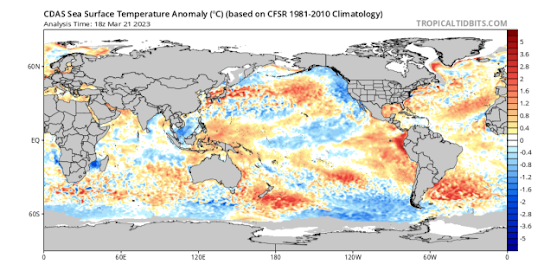
The Pacific continues to make some strong moves towards an El Nino with arguably the most change in the last 2 weeks out of the prior 5-6months. The Far East off Peru and Central America has warmed dramatically with a consistent warm signal (see Figure 1), and this is showing no signs of abating any time soon. Much further west, we are also seeing in the sub-surface a larger warm pool which has been slowly building for a couple of months but until now, has faced a battle against the trade winds halting it’s move east. However, some big MJO phases with stronger Westerly Wind Bursts (WWB) have finally overpowered or begin to overpower (still early we must remember) those trades allowing that warm water to expand and creep east. When this then begins to surface, we should transition into an El Nino, or at the very least a warm neutral setting but I think El Nino of a weak to moderate strength is the most likely outcome at this stage. Big moves have been made but more need to happen. One outcome that I have mentioned is if we do infact get the El Nino this year then next year may not be as dry or go further into El Nino territory, but should pull back to near average rainfall at the very least.
The Indian has chopped and changed in the last fortnight but no real strong signal either way. The warmth west of WA has crept closer and may be a short-term source of some potential NW Cloudband activity late March into early April although this is a weak signal as we come to the end of the tropical monsoon season. It is not unusual to get a rinse or drawdown from the tropics in drier years, especially around early April or late March and can be a false break before we swing dry and steady. Please be careful of that but of course any rainfall will be welcome. I do envisage some cooler anomalies forming off the coast of Java/Sumatra as we move into winter and spring consistent with a weakish positive IOD with more SE trades and less westerly influences.
The MJO has been barrelling across the Eastern Pacific and Atlantic in the last couple of weeks at a good strength and as mentioned above, has been responsible for the changes in the Pacific Ocean SST structure. It is now moving over Africa and ready to enter Phase 1 and 2 again which will be interesting as it comes closer to the mainland and may give us our window for a last tropical rinse with some infeeds before things go quieter. Tropical Cyclone action also may pick up with this. It should hold some strength but weaken a little from the current state.
The SAM has enjoyed a dip into the negatives which is why we have seen a lot of swell across Southern Australia in recent times. It has now moved back to neutral state and should remain there for a while, potentially into the positives again but no major bias either way. The upper levels however will remain quite meandering as the recent bombardment of solar winds has caused a lot of wild fluctuations in the upper winds with lots of kinking and cutting off and this should continue for another couple of weeks yet and will line up near the MJO passing for a swipe at getting some rain into the state out of the WNW.
Districts:
Eyre Peninsula
Weak upper disturbance may cause some very light patchy rain on 24th. Becoming fine ahead of deepening broad surface trough with increasing moisture from the NW. Upper trough to assist generating areas of patchy light rain from late on 25th but more likely increasing on 26th, chiefly about the Lower Eyre Peninsula at first before more rain extends across remaining districts later in the day. Isolated thunderstorms developing from late evening as secondary upper low pushes up. Morning rain areas and isolated thunderstorms clearing before lingering isolated showers remain through the 27th. New ridge building from west after however isolated showers in a moist S/SE flow, chiefly about the Spencer gulf side of the Peninsula will remain through the 29th-31st. Rainfall for the period in the order of 5-8mm, however isolated thunderstorms may bring localised totals to 20-25mm. Lighter totals towards the far N/NW portions of the Peninsula in the order of 3-5mm.
Upper North
Weak upper disturbance may cause some thickening mid-level cloud on 24th but apart from a very light shower, it should remain fine. Fine ahead of a deepening broad surface trough with increasing moisture from the NW from 25th. Close proximity of an upper ridge will deflect rainfall well south at first, however eventually an upper trough will assist generating areas of patchy light rain in the evening on 26th, chiefly in the south at first before more rain and isolated thunderstorms extend from the west by early 27th as secondary upper low pushes up. Morning rain areas and isolated thunderstorms clearing before lingering isolated showers remain through the 27th. Rain a lot more patchy and light over the Flinders. New ridge building from west after however isolated showers in a moist S/SE flow, will remain through the 29th-31st, chiefly about the elevated terrain south of about Jamestown. Rainfall for the period in the order of 3-5mm, however isolated thunderstorms may bring localised totals to 20mm. Minimal rainfall across the Flinders except for those receiving thunderstorm activity.
Lower North
Weak upper disturbance may cause some thickening mid-level cloud on 24th but apart from a very light shower, it should remain fine. Fine ahead of a deepening broad surface trough with increasing moisture from the NW from 25th. Close proximity of an upper ridge will deflect rainfall well south at first, however eventually an upper trough will assist generating areas of patchy light rain in the late afternoon and evening on 26th, chiefly in the south at first before more rain and isolated thunderstorms extend from the west by early 27th as secondary upper low pushes up. Morning rain areas and isolated thunderstorms clearing before lingering isolated showers remain through the 27th. New ridge building from west after however isolated showers and drizzle periods in a moist S/SE flow, will remain through the 29th-31st, chiefly about the elevated terrain and on windward slopes. Rainfall for the period in the order of 5-10mm, however isolated thunderstorms may bring localised totals to 20mm.
Yorke Peninsula
Weak upper disturbance may cause some thickening mid-level cloud on 24th but apart from a very light shower or patchy light rain area, it should remain fine. Fine ahead of a deepening broad surface trough with increasing moisture from the NW from 25th. Upper trough will assist generating areas of patchy light rain on 26th, chiefly about the foot at first before more rain and isolated thunderstorms extend from the west by early 27th as secondary upper low pushes up. Thunderstorm activity mostly confined to the north. Morning rain areas and isolated thunderstorms clearing before lingering isolated showers remain through the 27th. New ridge building from west after however isolated showers in a moist S/SE flow, will remain through the 29th-31st. Rainfall for the period in the order of 5-12mm, however isolated thunderstorms may bring localised totals to 20mm.
Kangaroo Island
Weak upper disturbance may cause some thickening mid-level cloud on 24th but apart from a very light shower or patchy light rain area, it should remain fine. Fine ahead of a deepening broad surface trough with increasing moisture from the NW from 25th. Upper trough will assist generating areas of rain on 26th before the rain becomes lighter and patchier in the evening. Lingering isolated showers remain through the 27th. New ridge building from west after however isolated showers in a moist S/SE flow, will remain through the 29th-31st. Rainfall for the period in the order of 12-18mm with isolated 20-25mm totals possible should the rainband thicken.
Adelaide Plains
Weak upper disturbance may cause some thickening mid-level cloud on 24th but apart from a very light shower, it should remain fine. Fine ahead of a deepening broad surface trough with increasing moisture from the NW from 25th. Upper trough will assist generating areas of patchy light rain from mid-morning on 26th, chiefly about southern suburbs at first before more rain and isolated thunderstorms extend from the west by early 27th as secondary upper low pushes up. Thunderstorm activity most likely about the outer plains. Morning rain areas and isolated thunderstorms clearing before lingering isolated showers remain through the 27th. New ridge building from west after however isolated showers and drizzle periods in a moist S/SE flow, will remain through the 29th-31st, chiefly about the elevated terrain and on windward slopes. Rainfall for the period in the order of 7-12mm, however isolated thunderstorms may bring localised totals to 20mm.
Mt.Lofty Ranges
Weak upper disturbance may cause some thickening mid-level cloud on 24th but apart from a very light shower, it should remain fine. Fine ahead of a deepening broad surface trough with increasing moisture from the NW from 25th. Upper trough will assist generating areas of patchy light rain from late morning on 26th, chiefly about southern coasts and ranges at first before more rain and isolated thunderstorms extend from the west by early 27th as secondary upper low pushes up. Thunderstorm activity most likely about the Northern Ranges. Morning rain areas and isolated thunderstorms clearing before lingering isolated showers remain through the 27th. New ridge building from west after however isolated showers and drizzle periods in a moist S/SE flow, will remain through the 29th-31st, chiefly about the elevated terrain and on windward slopes. Showers may become more frequent on the 30th and 31st with localised low-level convergence. Rainfall for the period in the order of 10-17mm, however isolated thunderstorms may bring localised totals to 20-25mm.
Riverland/Mallee
Weak upper disturbance may cause some thickening mid-level cloud on 24th but apart from a very light shower, it should remain fine. Fine ahead of a deepening broad surface trough with increasing moisture from the NW from 25th. Upper trough will assist generating areas of patchy light rain across the Mallee from mid-morning on 26th before more rain and isolated thunderstorms extend from the west by early 27th including the Riverland as secondary upper low pushes up. Morning rain areas and isolated thunderstorms clearing before lingering isolated showers remain through the 27th. New ridge building from west after however isolated showers in a moist S/SE flow, will remain through the 29th-31st, chiefly towards the back side of the ranges. Rainfall for the period in the order of 4-8mm, however isolated thunderstorms may bring localised totals to 20mm. Lighter totals potentially over the Riverland should the secondary band be weaker in the order of 2-4mm.
Upper SE
Weak upper disturbance may cause some thickening mid-level cloud on 24th but apart from a very light shower, it should remain fine. Fine ahead of a deepening broad surface trough with increasing moisture from the NW from 25th. Upper trough will assist generating areas of patchy light rain from late morning on 26th, chiefly about the western portion of the district at first before spreading throughout by early 27th as secondary upper low pushes up. Morning rain areas clearing before lingering isolated showers remain through the 27th. New ridge building from west after however isolated showers will linger in a moist S/SE flow. Rainfall for the period in the order of 12-18mm, with isolated totals in the order of 25mm possible.
Lower SE
Weak upper disturbance may cause some thickening mid-level cloud on 24th but apart from a very light shower, it should remain fine. Fine ahead of a deepening broad surface trough with increasing moisture from the NW from 25th. Upper trough will assist generating areas of patchy light rain from early to mid-afternoon on 26th, chiefly about the western portion of the district at first before spreading throughout by early 27th as secondary upper low pushes up. Morning rain areas clearing before lingering isolated showers remain through the 27th. New ridge building from west after however isolated showers will linger in a moist S/SE flow, more frequent about the coastline at times. Rainfall for the period in the order of 8-15mm, with isolated totals in the order of 20mm possible.
Western VIC
Weak upper disturbance may cause some thickening mid-level cloud on 24th but apart from a very light shower, it should remain fine. Fine ahead of a deepening broad surface trough with increasing moisture from the NW from 25th. Upper trough will assist generating areas of patchy light rain from late afternoon on 26th, chiefly about the western border of the SW and Wimmera district at first before spreading throughout including the Mallee by early 27th as secondary upper low pushes up. Morning rain areas with isolated thunderstorms over the Mallee clearing before lingering isolated to scattered showers remain through the 27th, mostly over the SW District and coastlines/windward slopes. New ridge building from west after however isolated showers will linger in a moist S/SE flow, more frequent about the coastline at times. Rainfall 8-12mm about the SW District with isolated 20mm totals, decreasing to 4-8mm about the Wimmera and Mallee although thunderstorm activity may cause local totals to 20mm across the Mallee.
Final Notes:
- Window of moisture for one or two systems, the first due 26th-27th March with another potentially in early April before we go dry again second half of April and into May.
- MJO is strong and should provide sufficient uplift and convergence to deliver good to very good rainfall for inland WA and adjacent cropping regions
- El Nino odds now increased to 70/30 from 60/40 last time with a weak to moderate strength the most likely outcome
- Weak positive IOD likely to accompany the El Nino
- Increased frost as a result of more high pressure through the growing season
- Most rainfall sourced from westerlies and fronts with Goyder's line most relevant this season
- Higher chance of strong westerlies through winter in zonal pattern
Link to temporary blog website: https://farmweathersa.blogspot.com/
Happy Farming and Cheers from The Weatherman
*Note – For interest only, all thoughts are of The Weatherman and may not be reproduced without my consent


Comments
Post a Comment