February 2023 update SA
February 2023 update SA
*Forecast prepared between Feb 17-20th 2023
Review:
G’Day everyone, hope you are keeping well, another mid-month update is upon us and although not a great deal has happened weather wise this month in SA, the overall patterns on a more global and regional scale are starting to show signs of shifting just a little bit. The pendulum is beginning its move back the other way as the La Nina gradually loses some muscle but that is just in the ocean’s, we still have the good ol atmospheric lag to deal with for a little while yet.
The first half of February has seen a wide array of conditions with the very cold start from the polar blast, with squally showers and damaging winds occurring over a swath of the SE of the state with some handy totals of rain, though generally for most areas south of about Adelaide. However, some handy streams did set up into the Lower and Upper North areas with Port Pirie of all places really nailing one evening with 20-25mm falling within the locale of the township. Most other totals were 4-8mm grading to less than 4mm for most areas west of the gulfs.
Once this cold air moved away, we were left in a generally stable pattern with oscillating ridges and weak surface wind changes with temperatures holding around average overall.
Meteorological Discussion:
The remainder of the month will see the expected heat come in with arguably the longest run of days above 35C across most districts we have seen this summer. The uptick in Tropical Cyclone activity from early to mid-month has caused this. Often, we see strong heat lows and deep upper ridging build over the interior, chiefly WA when we get a TC off the WA coastline. Now whilst there isn’t one at this point in time, TC Freddy did form a week ago and ever since, we’ve seen no ability for colder air to push up into WA from below WA, it has been mostly at best over VIC/TAS and even then, quite limp so essentially we see the heat oven recharge without any disturbance and all that is needed is a bit of a trough or front to stand up from the west with the ridge holding over the Tasman for that to channel down into SA and it will do so for the remainder of this week.
The bulk of the heat will channel itself over the western half of SA so if you draw a line down the middle of the Eyre Peninsula and up to the NT border, that is the main focus area for the hottest of the heat from Mon 20th to Thurs 23rd. Townships such as Nullarbor, Ceduna, Kyancutta, Tarcoola are especially likely to see some significant temperatures, especially the the first two with 850hPa temperatures (about 5,000ft) expected to reach around 30C near the WA/SA border in the period 21st to 23rd. An old rule of thumb is to add about 15C to that 850hPa temperature at about 25C, 16C at 30C, 17C at about 40C and up to 18C for 45C. So, a 29-30C 850hPa temperature out there could yield the potential for 47-48C which by SA standards in February, isn’t all that uncommon these days. Granted there may be some seabreeze action, 45-46C may be a little closer to the mark but it will be a close watch. A weak trough moves in later on the 24th bringing with it some isolated showers and thunderstorms, possibly tending to light patchy rain as it moves east but not a lot of rainfall is expected however fresh to strong winds are likely with the change and behind it as the temperature gradient will be quite large. As a result, elevated fire dangers are likely due to a combination of lightning and then windy conditions however winds will unlikely be as strong as the colder outbreak back at the start of the month. After this yet another new ridge will move in stabilising conditions apart from another weak front moving largely below the state around the 28th or so.
Climate Drivers
The Pacific is seeing a shift finally that has been many months in the making. After a battle royale between the warmth to the west and the cooling to the east with multiple re-invigorations of the cooler anomalies, the warmer water is finally starting to show its hand in the surface layer off Peru. Please refer to Figure 1.
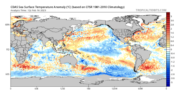
Figure 1: Current SST anomalies – source Tropical Tidbits https://www.tropicaltidbits.com/analysis/ocean/cdas-sflux_ssta_global_1.png
We can see here the small spike just starting to extend westward along the equator as the warmer sub-surface water begins to rise up. The remainder of the warm tongue is still sitting 15-250m below the surface and as this rises it will mix out however the classical westward extending spike as the warm water rises will occur as we move through winter and spring this year which is on track to produce the warm neutral to potentially weak El Nino like signatures.
Looking below to Figure 2, we can also see the change in the last 7 days and what is significant there is the large cooler area in the southern Coral Sea. This corresponds to where TC Gabrielle moved, and the broad wind field churned up a lot of cooler water from deeper down due to wave action – a very common signature after a Tropical Cyclone. I expect this to be temporary.
Overall, trade winds are still strong as there is a lag from the ocean to the atmosphere as we know so the actual on ground influence of La Nina will still remain but primarily only the Eastern states and the Tropics, especially around Cape York and inland below and near the Gulf of Carpentaria. I can see persist trade wind versus monsoonal convergence there for another solid month yet, increasing the risk of inland flooding down towards the northern portions of the Lake Eyre Basin.

Figure 2: SST anomaly change in last 7 days – source Tropical Tidbits https://www.tropicaltidbits.com/analysis/ocean/cdas-sflux_ssta7diff_global_1.png
The Indian remains largely unspectacular. Severe Tropical Cyclone Freddy continues to power westwards at an intensity of 135knots gusting to 165knots which is a category 5 cyclone and the strongest of the season by a considerable margin. I expect this one to power all the way over to Madagascar and then potentially into Africa as well after regathering itself over the Mozambique Channel. It is very rare to see a system make it that far west from something that formed off the NW WA coastline. It shows a powerful Subtropical Ridge (STR) is present across the Indian Ocean which shows an enhancement of easterlies. This means the focus for convergence is now a little further west than it has previously been meaning the trend towards drier conditions out of the Indian is beginning. Having said this, Tropical Cyclone action will still continue off WA through March and April with attempts for rain off of these most likely in March for us in SA.
THe MJO continues to march eastwards across the Pacific, and this was a focus for the recent burst of Tropical Cyclone action we saw (Freddy and Gabrielle) with both becoming Severe (Category 3 to 5). Current it is in phases 6 to 7 and soon will be right over the other side of the globe. The monsoon flow however still remains to the north of the mainland with a near constant convergence zone across the Cape York Peninsula and Gulf of Carpentaria.
The SAM is neutral to slightly negative at the moment with slightly more front action below the mainland. The trend will be back to slightly positive for the remainder of the month as strong upper ridging pushes hard to the south bringing heatwave conditions from inland much further south.
Districts:
Eyre Peninsula
Becoming hot to very hot throughout from the 21st as a strong high centred south of the mainland moves eastwards directing a NE-N flow across the district. E to NE winds fresh on the 21st as gradient remains tight, especially about the Lower Eyre Peninsula coastline. Very hot through till 23rd with temperatures in the low to mid 40’s ahead of a trough and cold front extending from the west early on the 24th with isolated showers and thunderstorms. Fire dangers will be elevated ahead of and near the change. Fresh SW-S winds and much cooler conditions in the wake of the front later on the 24th. A new ridge then establishing behind with mild to warm conditions to round out the month. Rainfall generally 1-4mm although isolated dumps to 8mm are possible in thunderstorms.
Upper North
Becoming hot to very hot throughout from the 21st as a strong high centred south of the mainland moves eastwards directing a NE-N flow across the district. Strong downslope gully winds are likely through the evening of the 20th and again during both the morning and evening of the 21st due to a tight gradient. Very hot through till 24th with temperatures in the low 40’s and near mid 40’s towards the Port Augusta area ahead of a trough and cold front extending from the west during the late afternoon and evening of the 24th with isolated showers and thunderstorms, possibly tending to light patchy rain at times. Fire dangers will be elevated ahead of and near the change. Fresh SW-S winds and much cooler conditions in the wake of the front during 25th. A new ridge then establishing behind with mild to warm conditions to round out the month. Rainfall generally 2-5mm although isolated dumps to 10mm are possible in thunderstorms.
Lower North
Becoming hot to very hot throughout from the 21st as a strong high centred south of the mainland moves eastwards directing a NE-N flow across the district. Strong downslope gully winds are likely through the evening of the 20th and again during both the morning and evening of the 21st due to a tight gradient. Very hot through till 24th with temperatures in the low 40’s ahead of a trough and cold front extending from the west during the late afternoon and evening of the 24th with isolated showers and thunderstorms, possibly tending to light patchy rain at times. Fire dangers will be elevated ahead of and near the change. Fresh SW-S winds and much cooler conditions in the wake of the front during 25th. A new ridge then establishing behind with mild to warm conditions to round out the month. Rainfall generally 3-6mm although isolated dumps to 10-12mm are possible in thunderstorms.
Yorke Peninsula
Becoming hot to very hot throughout from the 21st as a strong high centred south of the mainland moves eastwards directing a NE-N flow across the district. E to NE winds fresh on the 21st as gradient remains tight, especially about the foot and E coastline. Very hot through till 23rd with temperatures to near 40C ahead of a trough and cold front extending from the west late morning to early afternoon on the 24th with isolated showers and thunderstorms. Fire dangers will be elevated ahead of and near the change. Fresh SW-S winds and much cooler conditions in the wake of the front later on the 24th. A new ridge then establishing behind with mild to warm conditions to round out the month. Rainfall generally 2-5mm although isolated dumps to 8mm are possible in thunderstorms.
Kangaroo Island
Becoming hot to very hot throughout from the 21st as a strong high centred south of the mainland moves eastwards directing a NE-N flow across the district. E to NE winds fresh on the 21st as gradient remains tight, especially about the foot and E coastline. Hot to Very hot through till 23rd with temperatures in the high 30’s ahead of a trough and cold front extending from the west late morning to early afternoon on the 24th with isolated showers and thunderstorms. Fire dangers will be elevated ahead of and near the change. Fresh SW-S winds and much cooler conditions in the wake of the front later the 24th. A new ridge then establishing behind with mild to warm conditions to round out the month. Rainfall generally 1-4mm although isolated dumps to 5-6mm are possible in thunderstorms.
Adelaide Plains
Becoming hot to very hot throughout from the 21st as a strong high centred south of the mainland moves eastwards directing a NE-N flow across the district. Strong downslope gully winds are likely through the evening of the 20th and again during both the morning and evening of the 21st due to a
tight gradient. Very hot through till 24th with temperatures in the low 40’s about the outer plains ahead of a trough and cold front extending from the west during the late afternoon and evening of the 24th with isolated showers and thunderstorms, possibly tending to light patchy rain at times. Fire dangers will be elevated ahead of and near the change. Fresh SW-S winds and much cooler conditions in the wake of the front during 25th. A new ridge then establishing behind with mild to warm conditions to round out the month. Rainfall generally 3-6mm although isolated dumps to 10-12mm are possible in thunderstorms.
Mt.Lofty Ranges
Becoming hot to very hot throughout from the 21st as a strong high centred south of the mainland moves eastwards directing a NE-N flow across the district. Strong downslope gully winds are likely through the evening of the 20th and again during both the morning and evening of the 21st about the western slopes due to a tight gradient. Hot to very hot through till 24th with temperatures near 40C ahead of a trough and cold front extending from the west during the late afternoon and evening of the 24th with isolated showers and thunderstorms, possibly tending to light patchy rain at times. Fire dangers will be elevated ahead of and near the change. Fresh SW-S winds and much cooler conditions in the wake of the front during 25th. A new ridge then establishing behind with mild to warm conditions to round out the month. Rainfall generally 4-8mm although isolated dumps to 10-15mm are possible in thunderstorms.
Riverland/Mallee
Becoming hot to very hot throughout from the 21st as a strong high centred south of the mainland moves eastwards directing a NE-N flow across the district. Hot to very hot through till 24th with temperatures near 40C ahead of a trough and cold front extending from the west during the evening of the 24th with isolated showers and thunderstorms, possibly tending to light patchy rain as the band thickens a little. Fire dangers will be elevated ahead of and near the change. Morning patchy light rain and isolated thunderstorms clearing by dawn with fresh SW-S winds and much cooler conditions in the wake of the front during 25th. A new ridge then establishing behind with mild to warm conditions to round out the month. Rainfall generally 4-8mm although isolated dumps to 10-15mm are possible in thunderstorms.
Upper SE
Becoming hot to very hot throughout from the 21st as a strong high centred south of the mainland moves eastwards directing a NE-N flow across the district. Hot to very hot through till 24th with temperatures in the high 30’s ahead of a trough and cold front extending from the west during the late afternoon or early evening of the 24th with isolated showers and thunderstorms, possibly tending to light patchy rain as the band thickens a little. Fire dangers will be elevated ahead of and near the change. Morning patchy light rain and isolated thunderstorms clearing by dawn with fresh SW-S winds and much cooler conditions in the wake of the front during 25th. A new ridge then establishing behind with mild to warm conditions to round out the month. Rainfall generally 5-10mm although isolated dumps to 12-15mm are possible in thunderstorms or from areas of rain.
Lower SE
Becoming hot to very hot throughout from the 21st as a strong high centred south of the mainland moves eastwards directing a NE-N flow across the district. Hot to very hot through till 24th with temperatures in the high 30’s ahead of a trough and cold front extending from the west during the late afternoon or early evening of the 24th with isolated showers and thunderstorms, possibly tending to light patchy rain as the band thickens a little. Fire dangers will be elevated ahead of and near the change. Morning patchy light rain and isolated thunderstorms clearing by dawn with fresh SW-S winds and much cooler conditions in the wake of the front during 25th. Isolated onshore showers to follow during the day. A new ridge then establishing behind with mild to warm conditions to round out the month. Rainfall generally 5-10mm although isolated dumps to 12-15mm are possible in thunderstorms or from areas of rain.
Western VIC
Becoming hot to very hot throughout from the 21st as a strong high centred south of the mainland moves eastwards directing a NE-N flow across the district. Hot to very hot through till 24th with temperatures in the high 30’s ahead of a trough and cold front extending from the west during the evening of the 24th with isolated showers and thunderstorms, possibly tending to light patchy rain as the band thickens a little. Activity reaching the Mallee by late evening and into the early hours of the 25th. Fire dangers will be elevated ahead of and near the change. Morning patchy light rain and isolated thunderstorms clearing by mid-morning for most of the district with fresh SW-S winds and much cooler conditions in the wake of the front during 25th. Onshore isolated showers will persist about the SW coast and adjacent inland. A new ridge then establishing behind with mild to warm conditions to round out the month. Rainfall generally 5-12mm although isolated dumps to 12-20mm are possible in thunderstorms or from areas of rain.
Finals Notes:
- No changes to autumn outlook at this stage with potential for rain in March before a drying trend through April and May
- Weak El Nino or warm neutral at the very least still also looking likely through winter
- Positive IOD likely into spring but fairly weak but a slight reduction in rainfall may occur there too
- Heavy monsoon rain will dominate the northern portion of the country with a big focus across Cape York Peninsula and also the Top End.
- Continued uptick in Tropical Cyclones for March and early April
- Indian summer likely once again in April and May over Southern Australia.
Link to temporary blog website: https://farmweathersa.blogspot.com/
Happy Farming and Cheers from The Weatherman
*Note – For interest only, all thoughts are of The Weatherman and may not be reproduced without my consent.
Comments
Post a Comment