February 2023 Outlook SA
February 2023 outlook SA
*Forecast prepared between January 30th – Feb 2nd 2023
Review:
G’Day everyone, hope you are keeping well. February is now upon us, not long now and the all-important growing season sowing period will be here! I will delve into that a lot more in the next few updates as we hone in on the expected conditions.
January was another tricky month for the forecast and in many ways was very similar to 2022. A majority of the month was hot and dry, with both above average temperatures for most districts as well as below average rainfall right up until the 28th when a NW cloud-band developed along a very slow-moving cold front. This front initially looked like moving through fairly swiftly but a block to the east stalled things over the Far West of the state allowing more moisture to filter in from the tropics delivering areas of rain with some good falls across the Far West & West Coasts and also up into the NW Pastoral and no doubt these were welcome as these areas had been especially hot and dry beforehand. Rainfall totals from this event were mostly in the expected range of 8-15mm across the agricultural areas although some local totals did get more than expectations to near the old inch. Notable totals for the week ending 9am on 01/02/23 are as follows:
Now looking back on the month from a chart perspective, refer to the Figures 1-3 below:
My January outlook was as follows:
“The outlook overall for January is a below average month over the more southern portions of the state including most of the agricultural areas and west coast. Average conditions are likely into the interior and the far northern to NE border may see average to slightly above average with moreso the eastern half of the NE Pastoral a focus for above average rainfall with regards to the in-feed potential from QLD. Should this moisture push hard enough SW then some average to slightly above average localised pockets may appear over the eastern agricultural areas but this chance for now looks slim.”
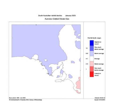


Figure 3: January 2023 rainfall anomalies – source BoM http://www.bom.gov.au/climate/
Meteorological Discussion
Now looking ahead to February and what lies in store for our shortest month of the year, to me it looks like bringing a fairly typical month but with a cold start.
Currently on the charts we have a weak front crossing the southern agricultural areas with a broken band of showers, mostly light although some a little heavier briefly. Most totals though are less than 2mm with some locations missing out altogether. Further south a stronger front is beginning to move NE and that will cross the state tomorrow (2nd) with much colder air and have a larger impact of VIC and TAS and southern NSW with cold conditions as well as squally showers, local cold air thunder and small hail, something not too common at this time of the year! The wind around the back side of a deep low that will form will be quite intense and no doubt severe weather warnings will be issued for this across VIC and TAS and also possibly SE of SA and for many it will feel like winter has returned but things will change quickly after this once again.
Further north across the tropics a weak monsoonal flow is providing convergence into inland NT delivering areas of rain and isolated thunderstorms, but with some heavy falls. WA is seeing the West Coast heat trough deepen with afternoon and evening showers and thunderstorms inland and well north gradually creeping back SW as the high slips into the Bight before a new ridge pushes activity back NE again. This oscillation will continue and allow a lot of heat to build and focus over WA with a couple of bursts into SA/NT as systems drag it back east. But back to SA and we will see that second stronger cold front push up rapidly from the SW as a strong upper trough launches out of the westerly belt, becoming quickly cut off. Squally showers will increase in frequency and intensity as one ventures towards the VIC border with a wet and windy 24-48hours for exposed coastlines between Mt.Gambier and essentially Melbourne at least. The cold front will be due into Kangaroo Island by around 9:30-10am on the 2nd before reaching Adelaide by about 12:30pm-1pm. A band of showers and increasing blustery WSW-SW winds will accompany this front, although may tend to rain about the Upper and Lower SE. Showers towards the weaker portion of the front with more NW extent will be lighter and the band likely fairly broken with more isolated activity and generally lighter falls from roughly N and NW of the Lower Eyre Peninsula.
Behind the front the colder air will then move in but initially at first there will be some form of brief temporary clearance with a post frontal subsidence inversion. Once the colder air pushes further NW as the cold upper trough moves NE then showers will begin to increase although especially so about the Lower SE where more frequent and heavier showers will follow the front a little more closely. Isolated cold air thunder is possible here. Fresh to strong and squally SW winds will dominate much of the SE portion of the state, especially about exposed windward coasts and ranges - not the best day to take the boat out!
By early on the 3rd, we will see a pivot in the cold pool with a subtending trough embedded slinging up from the south, directing a renewed burst of showers with a more southerly angle. Isolated cold air thunder is again likely about the Lower SE and potentially extending northwards as far as the Southern Mallee by the afternoon as solar heating allows stronger convective cold air showers to form. Further west and north will see an increase in showers, especially early in the morning to early afternoon with fresh to strong SW winds, gradually moderating later and with that the showers should also ease, become more isolated and largely contract to the Southern coasts and ranges and SE coast by the 4th as a new high pressure systems moves in from the Bight stabilising conditions statewide.
Beyond this we should see ridging and stable SE winds for a good 4-5 days before a trough starts to deepen over the interior. The most likely angle of this trough will be into the Eastern states although a weak one also may leave WA for the very Far West of SA as well. New high pressure ridging from the SW should hold the eastern trough primarily over the eastern states but retrograding of moisture will begin to increase for the NE Pastoral ahead of another trough extending from the west by the 10th-12th potentially with some light patchy rain or showers and isolated thunderstorms as we continue to ‘set up’ for a Tropical move south towards the second half and likely latter part of the month. So my overall outlook for February is average to below average for the Lower and Upper North, the Eyre Peninsula and West Coast and potentially into the NW Pastoral as well. The Mallee and Riverland will also be similar though possibly closer to average. Average to potentially slightly above average rain falls as possible about the far Lower SE and the Southern coasts and ranges as well as the far northern border areas. Most other areas will be average or slightly below however one decent rain event can really blow things to much above average over the drier areas. The greatest chance of strong infeed of moisture is the NE corner followed by the far western border form decayed TC activity.
Climate Drivers:
The Pacific has very slowly weakened the La Nina signature in the oceans however the trade winds currently are raging over the Central South Pacific with these winds heading straight for the Coral Sea ahead of the next approaching MJO. The source of these trades from what I can gather is the two enormous deep North Pacific cold cores low pressure systems which have generated massive swells for Hawaii recently. This surge of colder air has crossed the equator and now been deflected back W to SW in the trades and has given them a boost. The Coral remains above average in temperature but only just, but this will be ample fuel when mixed with the massive convergence inbound. I envisage a wet February for QLD, especially portions of the Tropical East coast and central northern inland where the Gulf of Carpentaria will come into play.

The Indian Ocean as we know has no real bearing on our weather in the summer period, but it does have a big say on the Monsoon and currently, we have very much average conditions across much of the basin. The water north of Onslow to Indonesia is slightly above average but the water off the Top End is slightly below average. Much further SW however off Africa we see a larger more significant warmer area with well above average temperatures. This needs to be watched as we move through autumn and winter as often, they can shift E then go north and back west around the Indian gyre.
The MJO is moving nicely across the Indian and has now entered phase 3 and will soon move into phase 4 before being smack bang over the tropical north from about Feb 5th. This will enhance the monsoon and bring significant flooding rainfall once again to Tropical Australia but especially so to Cape York Peninsula west of Townsville to Cairns and SE of the Gulf of Carpentaria where dual convergence will enhance uplift and heavy tropical rain and storms. I do expect a lot of this moisture to be heavily focused over NSW and QLD this month but also expect westward advection within easterly dips on many occasions into the NE parts of the state at the very least but not until at least mid-month. I am also more bullish on Tropical Cyclone activity from mid-month onwards as this MJO phase pushes into the Western Pacific. Typically it is then that we see an uptick so looking at two areas, one north of the Kimberly with a tradtional strong TC heading WSW and the other in the Coral Sea.
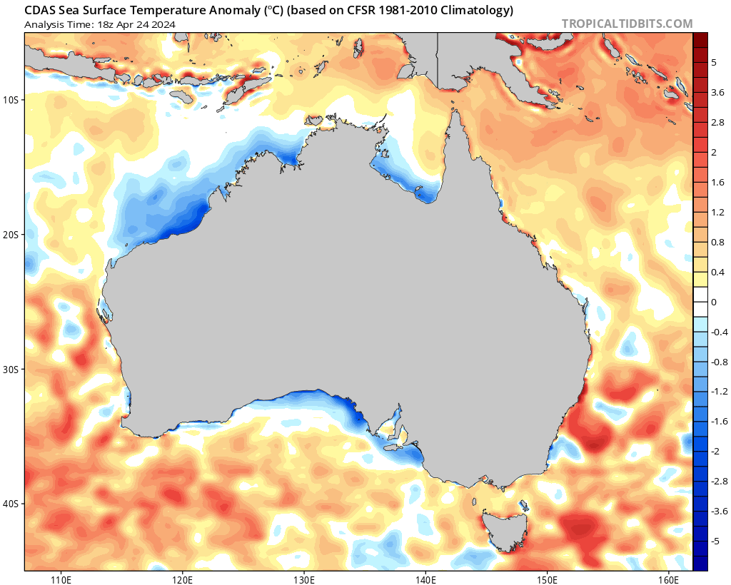
The SAM is positive but will have a brief dip back to negative in the coming days as we get the response from the release of the heat and easterly pattern that dominated us through the latter parts of January. This will mostly affect VIC, TAS, and southern NSW/SA with some very cold air for this time of the year. After this we should see the SAM swing back to positive levels once again. I should note that the sustained SE winds we have seen through January over SA has led to the classical cold water upwelling off the SE and Western EP coastlines with nutrient rich water being dragged up from the depths due to so much surface water transport away from the coastline and this has caused a massive phytoplankton bloom offshore which is visible from satellite E/SE of Kangaroo Island. See Figure 5 below for the anomalies.

Districts:
Eyre Peninsula
Cold front due around lunchtime on the 2nd over the Lower Eyre Peninsula bringing a broken band of showers before weakening with inland penetration with showers becoming more isolated later. Cool to cold with fresh to strong and blustery SW winds. Cold pool passing to the SE driving scattered showers about Lower EP on the 3rd but again becoming more isolated inland with fresh to strong SW-S winds moderating later and shower activity largely clearing by the 4th. New ridge and SE-E flow becoming established in days thereafter with rising temperatures before a second ridge tightens the flow by the 6th. Trough deepens over far NE of state from 8th before another trough extends from the west around 10th-11th potentially with some patchy rain. Temperatures rising before this trough with very hot conditions likely, especially over the West Coast and adjacent inland. Rainfall for the period 3-5mm, grading to less than 3mm inland.
Upper North
Cold front due around late afternoon on the 2nd bringing a broken band of showers before weakening with inland/eastern penetration with showers becoming more isolated later. Cool with fresh to strong and blustery SW winds. Cold pool passing to the SE driving isolated to scattered showers on the 3rd with a stream likely to run up the Spencer Gulf into the Melrose area with more concentrated shower activity. Fresh to strong SW-S winds moderating later with shower activity largely clearing by the 4th. New ridge and SE-E flow becoming established in days thereafter with rising temperatures before a second ridge tightens the flow by the 6th. Trough deepens over far NE of state from 8th before another trough extends from the west around 11th-12th potentially with some light patchy rain. Temperatures rising before this trough with very hot conditions likely, especially over the flat near Port Augusta and adjacent inland. Rainfall for the period generally 2-4mm grading to less than 1mm towards the back of the ranges. Local much higher totals in the Melrose area of 15-25mm possible.
Lower North
Cold front due around mid-afternoon on the 2nd bringing a broken band of showers before weakening with inland/eastern penetration with showers becoming more isolated later. Cool with fresh to strong and blustery SW winds. Cold pool passing to the SE driving isolated to scattered showers in from the SW-S on the 3rd once more. Fresh to strong SW-S winds moderating later with shower activity largely clearing by the 4th. New ridge and SE-E flow becoming established in days thereafter with rising temperatures before a second ridge tightens the flow by the 6th. Trough deepens over far NE of state from 8th before another trough extends from the west around 11th-12th potentially with some light patchy rain. Temperatures rising before this trough with hot to very hot conditions likely. Rainfall for the period generally 3-5mm grading to less than 1mm towards the back of the ranges. Local much higher totals in the Melrose area of 5-8mm possible towards the far north/NW of the district about elevated terrain or near any low-level streams that set up.
Yorke Peninsula
Cold front due around lunchtime on the 2nd over the foot bringing a broken band of showers. Cool to cold with fresh to strong and blustery SW winds. Cold pool passing to the SE driving scattered showers up from the SW-S on the 3rd before becoming isolated in the evening. Fresh to strong SW-S winds moderating later and shower activity largely clearing by the 4th. New ridge and SE-E flow becoming established in days thereafter with rising temperatures before a second ridge tightens the flow by the 6th. Trough deepens over far NE of state from 8th before another trough extends from the west around 10th-11th potentially with some light patchy rain. Temperatures rising before this trough with hot to very hot conditions likely in the north. Rainfall for the period 3-5mm.
Kangaroo Island
Cold front due around mid-morning on the 2nd bringing a band of showers. Cool to cold with fresh to strong and blustery SW winds. Cold pool passing to the SE driving scattered showers up from the SW-S on the 3rd, increasing from late morning to early afternoon before becoming isolated in the evening. Fresh to strong SW-S winds moderating later and shower activity largely clearing by the 4th with perhaps some light coastal shower activity remaining. New ridge and SE-E flow becoming established in days thereafter with rising temperatures before a second ridge tightens the flow by the 6th. Trough deepens over far NE of state from 8th before another trough extends from the west around 10th-11th potentially with some light patchy rain. Temperatures rising before this trough with hot to very hot conditions likely in the north. Rainfall for the period 3-5mm.
Adelaide Plains
Cold front due around lunchtime on the 2nd bringing a band of showers before weakening with inland/eastern penetration with showers becoming more isolated later. Cool to cold with fresh to strong and blustery SW winds. Cold pool passing to the SE driving isolated to scattered showers in from the SW-S on the 3rd once more, especially from late morning to early afternoon. Fresh to strong SW-S winds moderating later with shower activity largely clearing by the 4th. New ridge and SE-E flow becoming established in days thereafter with rising temperatures before a second ridge tightens the flow by the 6th. Trough deepens over far NE of state from 8th before another trough extends from the west around 11th-12th potentially with some light patchy rain. Temperatures rising before this trough with hot to very hot conditions likely. Rainfall for the period generally 4-8mm with isolated 10mm totals possible towards the foothills.
Mt.Lofty Ranges
Cold front due around lunchtime on the 2nd bringing a band of showers before weakening with inland/eastern penetration with showers becoming more isolated later. Cool to cold with fresh to strong and blustery SW winds, squally at times about exposed peaks and southern coast and ranges. Cold pool passing to the SE driving isolated to scattered showers in from the SW-S on the 3rd once more, especially from late morning to early afternoon. Fresh to strong SW-S winds moderating later with shower activity largely clearing by the 4th although lingering light onshore showers will remain about the southern coasts and ranges. New ridge and SE-E flow becoming established in days thereafter with rising temperatures before a second ridge tightens the flow by the 6th. Trough deepens over far NE of state from 8th before another trough extends from the west around 11th-12th potentially with some light patchy rain. Temperatures rising before this trough with hot to very hot conditions likely. Rainfall for the period generally 5-10mm with isolated 15mm totals possible towards the Southern windward/exposed ranges.
Riverland/Mallee
Cold front due around mid-afternoon on the 2nd for the Mallee and late afternoon for the Riverland bringing a broken band of showers before weakening with inland/eastern penetration with showers becoming more isolated later. Cool with fresh to strong and blustery SW winds. Cold pool passing to the SE driving isolated to scattered showers on the 3rd chiefly from late morning to early afternoon about the southern Mallee. Possible local thunder in the far south by early afternoon. Fresh to strong SW-S winds moderating later with shower activity largely clearing by the 4th. New ridge and SE-E flow becoming established in days thereafter with rising temperatures before a second ridge tightens the flow by the 6th. Trough deepens over far NE of state from 8th before another trough extends from the west around 11th-12th potentially with some light patchy rain. Temperatures rising before this trough with hot to very hot conditions likely. Rainfall for the period generally 2-4mm grading to less than 1mm towards Riverland. Local totals to 5-8mm possible in the south of the Mallee District.
Upper SE
Cold front due around lunchtime on the 2nd bringing a band of showers, possibly tending to rain, chiefly in the south before becoming more isolated later. Cool with fresh to strong and blustery SW winds. Cold pool passing to the SE driving renewed scattered showers on the 3rd chiefly from early morning to early afternoon. Possible local thunder by early afternoon. Fresh to strong SW-S winds moderating later with shower activity largely clearing by the 4th. New ridge and SE-E flow becoming established in days thereafter with rising temperatures before a second ridge tightens the flow by the 6th. Trough deepens over far NE of state from 8th before another trough extends from the west around 11th-12th potentially with some light patchy rain. Temperatures rising before this trough with hot to very hot conditions likely. Rainfall for the period generally 5-10mm with some isolated 12-15mm totals in the south possible.
Lower SE
Cold front due around early morning on the 2nd bringing a band of showers, possibly tending to rain, before a series of frequent squally showers follow. Cold with fresh to strong and blustery SW winds, gale force at times about exposed coasts and in showers. Cold pool passing over early on the 3rd driving renewed scattered showers, heavy at times chiefly from early morning to early afternoon. Isolated cold air thunder and small hail, more likely closer to the coast and VIC border areas. Fresh to strong SW-S winds moderating later with shower activity largely clearing by the 4th however light coastal showers will continue. New ridge and SE-E flow becoming established in days thereafter with rising temperatures before a second ridge tightens the flow by the 6th. Trough deepens over far NE of state from 8th before another trough extends from the west around 11th-12th potentially with some light patchy rain. Temperatures rising before this trough with hot to very hot conditions likely. Rainfall for the period generally 12-20mm with some isolated 25-30mm totals in the south possible.
Western VIC
Cold front due around late morning in the SW district on the 2nd bringing a band of showers, possibly tending to rain, before a series of frequent squally showers and isolated cold air thunder to follow. Cold with fresh to strong and blustery SW winds, gale force at times about exposed coasts and in showers. Cold pool passing over early on the 3rd with more unstable air driving renewed scattered showers, heavy at times chiefly from early morning to early afternoon about the SW District and Wimmera during the early to mid-afternoon. Isolated cold air thunder and small hail south of the Mallee District. Fresh to strong SW-S winds moderating overnight with shower activity becoming less intense and more confined to the SW District by the 4th before clearing by the 5th. New ridge and SE-E flow becoming established in days thereafter with rising temperatures before a second ridge tightens the flow by the 6th. Trough deepens over far NE of SA and into NSW from 8th before another trough extends from the west around 11th-12th potentially with some light patchy rain. Temperatures rising before this trough with warm to hot conditions likely, tending very hot about the Mallee. Rainfall for the period generally 15-25mm in the SW with isolated 35-40mm totals near the coast. Totals steadily decreasing with northern extent down to 5-10mm for the Wimmera and 1-3mm for the Mallee.
Finals Notes:
- Cold blast to bring wintry conditions to the SE with squally showers, small hail and local cold air thunder with snow on the alps.
- Uptick in Tropical Cyclone activity from Mid-month and continuing into March
- Murray flood peak now passed out to sea with a steady drop in levels but dirty water continuing to flush into Encounter Bay for many weeks yet
- El Nino and Positive IOD odds would be probably at 60-40 at this point in time for winter and spring or at least a warm neutral pattern leading to slightly drier conditions at this stage through growing season
- Inland rainfall likely through later Feb and March, especially for the Lake Eyre catchment.
Link to temporary blog website: https://farmweathersa.blogspot.com/
Happy Farming and Cheers from The Weatherman
*Note – For interest only, all thoughts are of The Weatherman and may not be reproduced without my consent.
Thank you for all the World-wide interest.


Comments
Post a Comment