January 2023 Update SA
January 2023 update SA
*Forecast prepared between January 17th-19th 2023
Review:
G’Day everyone, another update is due and although not a great deal has happened this month due to mostly stable conditions, there is some instability to come for the second half of the month.
January to date has been mostly hot and dry with weak SW/S changes bringing fresh to strong and cooler winds but little to no rainfall before the high-pressure systems march east and the NE/N flow comes back with hot to very hot conditions. This oscillating pattern has been fairly consistent. There was some moisture fed in briefly on the 11th (day before I expected) with afternoon showers and thunderstorms over the Lower and Upper North and Flinders with some locally heavy dumps. This was the first attempt of moisture into the state and was quickly shut down. Temperatures are running slightly above average for January although there hasn’t been any truly extreme days of heat but some good runs above 30C for many areas with numerous locations not recording a single drop for the month to date and as a consequence, the land is now becoming thirsty in many areas, though I know some of you are still finishing up the harvest and will prefer the rain to hold off for a little longer yet.
Meteorological Discussion
So, what lies in store for the rest of the month? In the January outlook I did expect the second half to show more moisture feeding in from QLD/NSW with afternoon thunderstorm potential from a westward moving easterly dip and mentioned that it may take a couple of attempts to get the moisture in properly and at this stage that looks to be the case which I will allude to shortly.
Firstly, though a quick look at the current charts and we have the remnants of a strong tropical low off the coast of QLD which has been converging heavy convective rain and thunderstorms into the
Mackay region (and Townsville too) for a number of days which rainfall totals approaching 800-1000mm in some locations with widespread 400-600mm totals. That is simply incredible rainfall, and the flooding has been significant. Fortunately, now that is easing as the low moves offshore, but the overall moisture is lingering over QLD.
Further south and a weak trough is moving east across VIC and NSW which crossed over SA yesterday (17th) bringing patchy rain areas in a series of slow-moving bands as well as some isolated thundery showers. Behind this trough is a cooler SW/S flow tending more SE later 18th and into 19th as a new ridge moves east and establishes.
Now after this is where things get a little interesting. One thing I always look for when we get weather from the east or NE is a big flood event in QLD. In Jan 1998 we had the Townsville floods and a few days later on Jan 12/13th we had the most tremendous afternoon thunderstorms in a hot and humid NE flow, right down into the suburbs – I can remember on the 13th seeing the Phillip Highway in Elizabeth nearly 1m under water from a flash flooder.
Now this current setup I do not see anywhere near that potential but nevertheless the moisture will feed SW into a westward moving surface trough, with areas east of the ranges seeing some afternoon cloud from the 21st and then afternoon showers on the 22nd. Thunderstorms will be more widespread over the border as is so often the case in these setups early on. On the 23rd the trough will be at its most western in location and at the same time a weak upper trough or upper low waffles over the top from the west, steepening lapse rates across the agricultural areas but with a focus on and east/SE of the ranges and north of Adelaide. I would expect morning scattered showers and isolated high based weak thunderstorms to translate to afternoon and evening showers and thunderstorms in those above areas, with less to nil activity west of the gulfs due to the location of the surface trough and more stable S/SE winds.
Beyond this the high in the Bight will push a ridge east shifting the trough back over the Eastern border and favouring thunderstorms over NSW and VIC once more with more stable S/SE winds over most of the state however the eastern border anywhere from the Lower SE to the Southern NE Pastoral may still see some lingering shower and thunderstorm activity, more likely in the afternoon on the 24th.
After this we see the high moves eastwards allowing another more significant burst of heat to flux south from the interior of WA/SA driving temperatures well into the 40’s for most districts, even more southern coastal ones. Often a cold front cleans this sort of pattern out before a quick reset with a new easterly dip trying to re-establish so I will watch for this pattern into early February. At this stage a stronger change/cold front may approach around the 28th/29th with a thundery change
but it is a little far off to be specific. February still looks like delivering similar conditions to Jan but potentially some hotter days into the low to mid 40’s with more southern extent followed by fresh changes.
Climate Drivers:
The Pacific has barely changed in the last fortnight, still in La Nina conditions but not quite to the strength of late last year. It will take multiple Westerly Wind Bursts (WWB’s) with warmer water pushing east to really knock it on the head completely so this will be a slow enough process. The Coral remains above average despite recent convective and cooling feedback with rain and is most certainly having a big influence on the major flooding through the Mackay area and its surroundings.
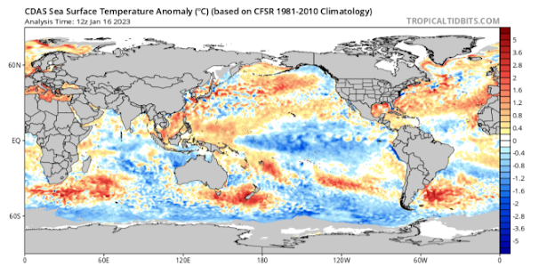
Figure 1: Current SST anomalies – source Tropical Tidbits
The Indian is very mundane for this time of the year, with no real impact on our weather although the cooler than normal anomalies off WA remain thanks to the monsoonal influence but this will warm back up a little before the next monsoon burst comes in late Jan and early Feb. Interesting to note is how warm the SW Indian is off Madagascar and South Africa, I’ll be watching to see if this does indeed wander north through the Indian gyre into autumn which would enhance drier conditions on our side. It is at least likely to fade a little once frontal influence begins to move in through autumn.
The MJO is in a sinking or downwelling phase over the Australian/Indo region atm (see Figure 2) however by the end of Jan and into Feb the next wave will be pushing into our doorstep in phase 3 and then 4 bringing the next main monsoonal flow. Cross equatorial flow will be key as so far, the monsoon has been a greater flow than previous years thanks to large Siberian highs. Just recently twin powerful deep North Pacific Mid-latitude cold core lows dominated from just east of Japan all the way to Alaska throwing a lot of cold air to the south and this may get accelerated further with another strong Siberian high in the coming week so that will be something to keep an eye on for a monsoon boost.
The SAM is currently positive but should essentially taper into neutral territory over the next 2 weeks with no powerful signal either way however as the next monsoon becomes established, I would expect a renewed burst back into the positive range with more heatwave potential through Feb as a result.

Figure 2: Current MJO showing downwelling (red/brown) over Australia – source Mike Ventrice http://mikeventrice.weebly.com/mjo.html
Districts:
Eyre Peninsula
A dominant SE flow across the district thanks to a steady ridge in the Bight. Westward moving surface trough out of NSW/VIC from 21st to 23rd will combine with eastern moving upper trough on 23rd to generate isolated afternoon and evening showers and thunderstorms about Eastern Eyre Pen, though tending less frequent in the remaining districts. Milder conditions will follow as all systems contract eastwards with a SE/E regime becoming established before becoming very hot late in the period with freshening N to NW winds and elevated fire dangers around 27th & 28th ahead of a cold front with showers and isolated thunderstorms. Milder fresh to strong SW/S winds behind this change. Rainfall for the remainder of the month around 3-8mm however isolated local totals in thunderstorms could reach up to 30mm.
Upper North
A dominant SE flow across the district thanks to a steady ridge in the Bight. Westward moving surface trough out of NSW/VIC from 21st to 23rd will combine with eastern moving upper trough on 23rd. Mostly fine however there may be isolated afternoon showers and a possible thunderstorm about the ranges on the 22nd before more instability on 23rd will see renewed isolated showers and thunderstorms, possibly tending scattered in the afternoon and evening, chiefly further east. Milder conditions will follow as all systems contract eastwards before becoming very hot late in the period with freshening N to NW winds and elevated fire dangers around 27th & 28th ahead of a cold front with showers and isolated thunderstorms. Milder fresh to strong SW/S winds behind this change. Rainfall for the remainder of the month around 3-8mm however isolated local totals in thunderstorms could reach up to 30-35mm.
Lower North
A dominant SE flow across the district thanks to a steady ridge in the Bight. Westward moving surface trough out of NSW/VIC from 21st to 23rd will combine with eastern moving upper trough on 23rd. Mostly fine however there may be isolated afternoon showers and a possible thunderstorm about the ranges on the 22nd before more instability on 23rd will see renewed isolated showers and thunderstorms, tending scattered in the afternoon and evening about the ranges with local heavy falls under stronger thunderstorms possible. Milder conditions will follow as all systems contract
eastwards before becoming very hot late in the period with freshening N to NW winds and elevated fire dangers around 27th & 28th ahead of a cold front with showers and isolated thunderstorms, possibly tending to areas of rain at times. Milder fresh to strong SW/S winds behind this change. Rainfall for the remainder of the month around 5-12mm however isolated local totals in thunderstorms could reach up to 30-40mm.
Yorke Peninsula
A dominant SE flow across the district thanks to a steady ridge in the Bight. Westward moving surface trough out of NSW/VIC from 21st to 23rd will combine with eastern moving upper trough on 23rd to generate isolated afternoon and evening showers and thunderstorms, more likely in the north. Milder conditions will follow as all systems contract eastwards with a SE/E regime becoming established before becoming very hot late in the period with freshening N to NW winds and elevated fire dangers around 27th & 28th ahead of a cold front with showers and isolated thunderstorms, possibly tending to areas of rain. Milder fresh to strong SW/S winds behind this change. Rainfall for the remainder of the month around 5-10mm however isolated local totals in thunderstorms could reach up to 20mm.
Kangaroo Island
A dominant SE flow across the district thanks to a steady ridge in the Bight. Westward moving surface trough out of NSW/VIC from 21st to 23rd will combine with eastern moving upper trough on 23rd to generate isolated evening showers and thunderstorms though with less vigour than more mainland districts. Cooler conditions will follow as all systems contract eastwards with a SE/E regime becoming established before becoming hot to very hot late in the period with freshening N to NW winds and elevated fire dangers around 27th & 28th ahead of a cold front with showers and isolated thunderstorms, possibly tending to areas of rain. Milder fresh to strong SW/S winds behind this change. Rainfall for the remainder of the month around 8-15mm.
Adelaide Plains
A dominant SE flow across the district thanks to a steady ridge in the Bight. Westward moving surface trough out of NSW/VIC from 21st to 23rd will combine with eastern moving upper trough on 23rd. Mostly fine however there may be isolated afternoon showers on the 22nd before more instability on 23rd will see renewed isolated showers and thunderstorms, tending scattered in the afternoon and evening north of Adelaide with local heavy falls under stronger thunderstorms possible. Milder conditions will follow as all systems contract eastwards before becoming very hot late in the period with freshening N to NW winds and elevated fire dangers around 27th & 28th ahead of a cold front with showers and isolated thunderstorms, possibly tending to areas of rain at times. Milder fresh to strong SW/S winds behind this change. Rainfall for the remainder of the month around 5-12mm however isolated local totals in thunderstorms could reach up to 30-40mm.
Mt.Lofty Ranges
A dominant SE flow across the district thanks to a steady ridge in the Bight. Westward moving surface trough out of NSW/VIC from 21st to 23rd will combine with eastern moving upper trough on 23rd. Mostly fine however there may be isolated afternoon showers on the 22nd before more instability on 23rd will see renewed isolated showers and thunderstorms, tending scattered in the afternoon and evening north of about Mt.Lofty with local heavy falls under stronger thunderstorms possible. Milder conditions will follow as all systems contract eastwards before becoming very hot late in the period with freshening N to NW winds and elevated fire dangers around 27th & 28th ahead of a cold front with showers and isolated thunderstorms, possibly tending to areas of rain at times. Milder fresh to strong SW/S winds behind this change. Rainfall for the remainder of the month around 8-15mm however isolated local totals in thunderstorms could reach up to 30-40mm.
Riverland/Mallee
A dominant SE flow across the district thanks to a steady ridge in the Bight. Westward moving surface trough out of NSW/VIC from 21st to 23rd will combine with eastern moving upper trough on 23rd. Mostly fine however there may be isolated afternoon showers about the eastern border late 21st. Isolated afternoon and evening showers and a possible thunderstorm on the 22nd before more instability on 23rd will see renewed isolated showers and thunderstorms, possibly tending scattered in the afternoon and evening with local heavy falls under stronger thunderstorms. Early morning
scattered showers and isolated thunderstorms lingering on 24th before clearing. Milder conditions will follow as all systems contract eastwards before becoming very hot late in the period with freshening N to NW winds and elevated fire dangers around 28th-29th ahead of a cold front with showers and isolated thunderstorms, possibly tending to rain areas later over the Mallee. Milder fresh to strong SW/S winds behind this change. Rainfall for the remainder of the month around 5-10mm however isolated local totals in thunderstorms could reach up to 30-40mm.
Upper SE
A dominant SE flow across the district thanks to a steady ridge in the Bight. Westward moving surface trough out of NSW/VIC from 21st to 23rd will combine with eastern moving upper trough on 23rd. Mostly fine however there may be isolated afternoon showers about the eastern border late 21st. Isolated afternoon and evening showers and a possible thunderstorm on the 22nd before more instability on 23rd will see renewed isolated showers and thunderstorms, possibly tending scattered in the afternoon and evening in the north. Morning scattered showers and isolated thunderstorms clearing on 24th before renewed isolated afternoon and early evening showers and thunderstorms develop although very close to the border. Milder conditions will follow as all systems contract eastwards before becoming very hot late in the period with freshening N to NW winds and elevated fire dangers around 28th-29th ahead of a cold front with showers and isolated thunderstorms, possibly tending to rain areas later. Milder fresh to strong SW/S winds behind this change. Rainfall for the remainder of the month around 5-10mm however isolated local totals in thunderstorms could reach up to 30-40mm.
Lower SE
A dominant SE flow across the district thanks to a steady ridge in the Bight. Westward moving surface trough out of NSW/VIC from 21st to 23rd will combine with eastern moving upper trough on 23rd. Mostly fine however there may be isolated afternoon showers about the eastern border late 21st. Isolated afternoon and evening showers and a possible thunderstorm on the 22nd before more instability on 23rd will see renewed isolated showers and thunderstorms later in the afternoon and evening. Morning scattered showers and isolated thunderstorms clearing on 24th before renewed isolated afternoon and early evening showers and thunderstorms develop although very close to the border. Milder conditions will follow as all systems contract eastwards before becoming hot to very hot late in the period with freshening N to NW winds and elevated fire dangers around 28th-29th ahead of a cold front with showers and isolated thunderstorms, possibly tending to rain areas later. Cooler fresh to strong SW/S winds behind this change. Rainfall for the remainder of the month around 5-10mm however isolated local totals in thunderstorms could reach up to 30-40mm.
Western VIC
A dominant SE flow across the district thanks to a steady ridge in the Bight. Westward moving surface trough will generate isolated to scattered afternoon and evening showers and thunderstorms on 21st chiefly about the Mallee and Wimmera and less likely further south. More isolated afternoon and evening showers and thunderstorms will re-develop within the trough on the 22nd but again a little less likely further to the south/SW corner of the state. Eastwards moving upper trough on both 23rd and 24th will see mostly fine conditions at first on 23rd but late afternoon or early evening showers and isolated thunderstorms extending from the NW. Showers and isolated thunderstorms continuing 24th with a brief clearance mid to late morning before afternoon convection allows renewed showers and isolated thunderstorms to develop. Mild conditions after the trough contracts eastwards with a new ridge. Hot to very hot conditions with freshening N to NW winds and elevated fire dangers around 28th-29th ahead of a cold front with showers and isolated thunderstorms, possibly tending to rain areas later. Milder fresh to strong SW/S winds behind this change. Rainfall for the remainder of the month around 5-10mm however isolated local totals in thunderstorms could reach up to 30-40mm.
Finals Notes:
- La Nina still holding on despite a slight weakening trend with QLD still likely to see more heavy rainfall, both coastal and inland. This could still spill towards the Northern Murray-Darling Basin in NSW as Coral Sea moisture continues to pump in
- Afternoon and evening thunderstorms on 23rd won’t be to the levels we have seen in November however local dumps may cause wet microbursts and local flash flooding. Large hail is a much lower risk but not completely ruled out.
- The devastating Murray flood peak has now moved down to the Lower Lakes and Goolwa regions and will continue to discharge significant quantities of dirty water into Encounter Bay with discolouration likely for a number of weeks to come yet, potentially easing by mid to late March.
- Tropical Cyclone uptick likely in both February and March with more extreme heat potential in Feb than Jan
- Autumn outlook still looking similar to last update, March may see lingering tropical activity before a wane and lacklustre frontal mode through April and May
- Overall, a drier year than 2022 statewide with the exception potentially of the far northern interior which may be subject to tropical inland heavy rains from monsoonal lows or Ex Tropical Cyclones.
Link to temporary blog website: https://farmweathersa.blogspot.com/
Happy Farming and Cheers from The Weatherman
*Note – For interest only, all thoughts are of The Weatherman and may not be reproduced without my consent.


Comments
Post a Comment