November 2022 Update SA
November 2022 update SA
*Forecast prepared between Nov 20th-22nd 2022
Review:
G’Day everyone, quite late this time sorry but really hope you are all doing well and are no doubt flat chat trying to sort crops out In between all this rain despite a nice warm to hot period a couple of weeks ago, its been a tough month so far with numerous strong cut off lows with showers, thunderstorms and flooding on rinse and repeat. But there is some good news! Firstly though I’ll cover the more noteable events below briefly.
Early November saw a barrage of very cold air on the 1st which drove squally showers, cold air thunder and numerous showers of small hail up from the deep south with a bitterly cold day. Rainfalls were already solid from the days prior, and rivers began to get quite swollen. A quick change and conditions warmed up with a burst of low to mid 30’s for many areas on the 8th and 9th which would have been welcome, but it did not last with a major thunderstorm outbreak on the 12th with a strong and slow moving cut off low. Numerous supercell thunderstorms spawned, especially across the Mid North areas where I was at the time and into the southern NE pastoral and Western Riverland. Heavy falls, flash flooding, large hail and damaging winds impacted crops with totals up to 90-100mm across the Mid North near Spalding to Booborowie. Further south over the Adelaide area and less organised thunderstorms occurred but heavy training and repeat storms caused flash flooding. Towards the mid-afternoon a squall line delivered damaging winds across a wide swath, felling trees and powerlines across the metro area and I noted traffic lights out for 4-5 days post event. The ceiling at my parents' house collapsed in the kitchen from water build-up, causing all sorts of mess. Fortunately, insurance is onto that!
And just recently we’ve copped another strong trough bringing showers and thunderstorms, although not as major as the 12th event, still strong enough to bring severe thunderstorms across the Riverland, Lower North, Mallee and Upper SE with flash flooding and damaging winds. A particularly strong left moving supercell hit Loxton on the 19th causing severe damage to vines with stripping of fruit and general tree damage around the area. Numerous crops were also damaged which is very sad after such huge rainfall boosting the size, a rarity for this region.
The Eastern states have unfortunately copped signifcant rainfall, especially around the Forbes area with thunderstorms and lingering heavy rain areas causing very rapid rising in the Wyanngala Dam which rose nearly 2m in one day resulting in a very powerful spill with a raging torrent entering the Lachlan River causing rapid flash flooding downstream and a higher peak in Forbes than a few weeks prior. All of this is moving downstream towards SA whilst the Darling peak is approaching Bourke
Meteorological Discussion:
Now that we are well past the halfway mark of the month, it is quite clear that it will be an above average month rainfall wise for most districts as expected. However, there is a small to moderate length window coming now for a bit of drying out before the end of the month as the entire pattern nation wide goes in to full blown reset mode with a contraction back of this current westerly belt allowing the moisture to build from the tropics. At the same time the negative IOD has weakened so the upper troughing will also taper off leaving more ‘settled’ conditions compared to what we have seen but still fairly standard or normal patterns – just devoid of the massive triggers and uplift that we have been seeing for a good 2-3months now. This will be a very good opportunity to tackle the harvest with gusto for those that are able to get into their paddocks without having heavy machinery get bogged.
A weak monsoon burst is likely very late November or more so early December and may last a week or so with stronger infeeds possible from that point onwards although with a bias to inland areas of the state and also QLD and NSW with a lesser chance down to VIC. I’d at least expect one or two monsoon lows to form within the very weak trough around the Top End increasing rainfall there before the easterlies return to more standard strong showers and thunderstorms. In terms of the flood situation, this period will allow a break in the topping up of already flooded catchments but once the infeeds push further south through the mid to latter part of December, I would be expecting some renewed flows to enter the flooded Murray Darling Basin, especially the Northern parts of the basin.
But the real issue is what is already there and this has been expected for quite some time now with the government finally catching up to the dire flows that are likely. I’ve been expecting a peak in the vicinity of 1974 for a fair while but to be honest I know that is being conservative with a pretty good chance that could come closer or beat 1931 with flows of around 230-250GL a day at the border. Quite a few old timers are talking 1956 which to me is a bridge too far but nevertheless worth keeping an eye on. Many shacks will be inundated completely and towns at threat if the levees don’t hold in places like Mannum, Renmark and Morgan and parts of Loxton and to be honest any town big or small along that strength. The river in SA can handle a big flow with a lot of overflow areas outside the main channel but this will make for a large and deep river. Granted the amount of water upstream still, the full Dartmouth still releasing water and the high chance of renewed flooding rainfall from tropical intrusions through mid to late Dec and on and off through the remainder of summer, many flood peaks of varying intensity will occur. This will be a very long and drawn out flood to please be prepared to be either isolated or have your shack affected for multiple months.
Further south though weak to moderate strength high pressure will become the norm with weaker troughs and cooler changes keeping the main heat at bay inland. The main features are likely to be a weak trough on the 25th and 26th extending isolated mid level showers and thunderstorms across the western parts of the state later on 25th before progressing eastwards. This feature is unlikely to bring any significant rainfall with no decent upper triggers. After this weak onshore frontal action is likely for a few days, chiefly with southern coastal areas and SE Districts being affected with totals still remaining less than a few mm as a couple of weak fronts move through on the 27th and 28th.
Climate Drivers
The Pacific is showing no signs of any change with an established La Nina holding firm. The western Pacific remains quite warm with a focus over the Coral Sea and this area is a real trump card as we head into the Monsoon season. I expect significant infeeds from this area into QLD and then down into NSW/VIC from time to time as well as the Gulf of Carpentaria over the summer months. The La Nina will break down through mid to later summer in the oceans but the lag to the atmosphere should hang on till about March, which is a little longer than it initially looked a couple of months ago.
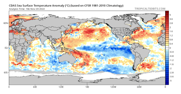
The Indian we can finally say has reverted back from a Negative IOD in the oceans to more of a neutral one with the latest index reading being –0.33C on Nov 6th. The lag to the atmosphere is always a little longer so we will still see some form of influence with those cut off type lows or deep troughs out of the west for a bit longer yet before a wane of sorts in the upper levels through December.
The MJO has moved right into our window atm with a broad area of convection to the N and NW of the continent as well as across the general Top End and Kimberly. It is at weak to moderate strength and will cause a general increase in storm and rain activity across Northern Australia although less severe storms due to a decrease in wind shear which is typical of the MJO. The timing of this MJO however is not favourable (good news) to link up with deep inland lows or upper troughs like we have seen so much of this spring as the westerly belt has expanded with a weak negative SAM phase. The MJO should move east right around the globe and re-emerge in the Western Indian mid to late December to trigger the first proper monsoonal burst.

Figure 2: Current MJO shown via CHI200 – source Mike Ventrice http://mikeventrice.weebly.com/mjo.html
The SAM has made a little flick back to negative with this burst of westerlies which is not unusual after such suppression for so long, but I don’t envisage a long-lived burst, things will quickly revert back to neutral to positive again as moisture builds towards the north. New heat lows will form over WA and begin to deepen and drop SE as we move into December. I don’t expect the power of warm/cold interaction like October and November have brought but still above average in strength with more tropical work than severe cut off lows, especially biased towards the eastern states.
Districts:
Eyre Peninsula
Becoming fine apart from light coastal shower or two about Lower Eyre Peninsula on morning of 23rd. New high pressure system moving east controlling weather till 25th when conditions will become hot to very hot, chiefly towards the West Coast. Trough extending from west late 25th or early 26th with isolated showers and thunderstorms but minimal rainfall. Cooler onshore flow with weak fronts on 27th and again 28th generating isolated showers, chiefly about the Lower Eyre Peninsula once again before clearing later. Conditions remaining mild for remainder of the month. Rainfall expected less than 2-3mm.
Upper North
Becoming fine as a new high pressure system begins moving east controlling weather till 25th when conditions will become hot to very hot, chiefly towards the iron triangle on the flat. Trough extending from west early 26th with isolated showers and thunderstorms but minimal rainfall. Cooler onshore flow with weak fronts on 27th and again 28th generating isolated showers in the far south about elevated terrain before clearing later. Conditions remaining mild for remainder of the month. Rainfall expected less than 1-2mm.
Lower North
Becoming fine as a new high pressure system begins moving east controlling weather till 25th when conditions will become warm to hot, chiefly towards the Upper North and also plains to the SW. Trough extending from west early 26th with isolated showers and possible thunderstorms but minimal rainfall. Cooler onshore flow with weak fronts on 27th and again 28th generating isolated to scattered showers before clearing later. Conditions remaining mild for remainder of the month. Rainfall expected less than 2-4mm.
Yorke Peninsula
Becoming fine apart from a light morning shower or two early 23rd before a new high pressure system begins moving east controlling weather till 25th when conditions will become warm to hot, chiefly towards the Northern portion of the Peninsula. Trough extending from west early 26th with isolated showers and possible thunderstorms but minimal rainfall. Cooler onshore flow with weak fronts on 27th and again 28th generating isolated to scattered showers before clearing later. Conditions remaining mild for remainder of the month. Rainfall expected less than 2-4mm.
Kangaroo Island
Becoming fine apart from some lingering light showers early on the 23rd before a new high pressure system begins moving east controlling weather till 25th when conditions will become mild to warm, especially towards the centre of the island. Trough extending from west early 26th with isolated showers and possible thunderstorms but minimal rainfall. Cooler onshore flow with weak fronts on 27th and again 28th generating scattered showers or a band of showers with the fronts before clearing later. Conditions remaining mild for remainder of the month. Rainfall expected less than 3-5mm.
Adelaide Plains
Becoming fine apart from a light morning shower or two before a new high pressure system begins moving east controlling weather till 25th when conditions will become warm to hot, especially over the outer northern plains. Weakening trough extending from west early 26th with isolated showers and possible thunder but minimal rainfall. Cooler onshore flow with weak fronts on 27th and again 28th generating isolated to scattered showers before clearing later. Conditions remaining mild for remainder of the month. Rainfall expected less than 3-5mm.
Mt.Lofty Ranges
Becoming fine apart from a light morning shower or two, chiefly in the south before a new high pressure system begins moving east controlling weather till 25th when conditions will become mild to warm and even hot, especially towards the north. Weakening trough extending from west early 26th with isolated showers and possible thunder but minimal rainfall. Cooler onshore flow with weak fronts on 27th and again 28th generating scattered showers before clearing later. Conditions remaining mild for remainder of the month. Rainfall expected less than 5-8mm although onshore flow about southern coasts and ranges may result in some 10-15mm totals if streams do establish.
Riverland/Mallee
Becoming fine as a new high pressure system begins moving east controlling weather till 25th when conditions will become warm to hot, chiefly over the Riverland. Trough extending from west during early to mid afternoon on 26th with isolated showers and possible thunderstorms but minimal rainfall. Cooler onshore flow with weak fronts on 27th and again 28th generating isolated showers in the far south of the Mallee before clearing later. Conditions remaining mild for remainder of the month. Rainfall expected less than 1-2mm in the Riverland but ranging up to 5mm about the southern Mallee.
Upper SE
Becoming fine as a new high pressure system begins moving east controlling weather till 25th when conditions will become warm to hot, chiefly with northern extent. Trough extending from west late morning or early afternoon on 26th with isolated showers and possible thunder but minimal rainfall. Cooler onshore flow with weak fronts on 27th and again 28th generating isolated to scattered showers before clearing later. Conditions remaining mild for remainder of the month. Rainfall expected less than 3-5mm.
Lower SE
Becoming fine apart from a light morning shower or two on 23rd before a new high pressure system begins moving east controlling weather till 25th when conditions will become warm, chiefly with northern extent. Trough extending from west late morning or early afternoon on 26th with isolated showers and possible thunder but minimal rainfall. Cooler onshore flow with weak fronts on 27th and again 28th generating bands of showers or scattered showers, more so on 27th before clearing later. Further weak front possible on 30th with light shower activity. Conditions remaining mild for remainder of the month. Rainfall expected less than 5-10mm though isolated 10-15mm totals are possible about the coastline.
Western VIC
Becoming fine apart from a light morning shower or two about the SW district on 23rd before a new high pressure system begins moving east controlling weather till 26th when conditions will become warm, chiefly with northern extent and potentially hot over the Mallee District. Trough extending from west later in the afternoon on 26th with isolated showers and possible thunderstorms but minimal rainfall. Cooler onshore flow with weak fronts on 27th and again 28th generating bands of showers or scattered showers, more so on 27th before clearing later. Further weak front on 30th with light shower activity about the SW District coastal areas. Conditions remaining mild for remainder of the month. Rainfall expected less than 5-10mm though isolated 12-20mm totals are possible about the coastline of the SW District.
Finals Notes:
- Much needed break for those needing to harvest and allow paddocks to dry out with settled conditions for many of the remaining days left this month
- December should start off fairly stable however with increasing moisture feeding in from north poses renewed thunderstorm risk from mid month, possibly earlier if moisture hurries back up
- Eastern states receive a shorter break and a stronger re-invigoration of moisture from the N, chiefly QLD and NSW and potentially inland VIC but less likely with southern extent.
- Big inland flooding is not finished yet and with any moisture intrusion through the summer will bring further flooding, some significant on saturated areas
- Heavy falls will tend to more inland areas such as Lake Eyre Basin as summer progresses
- Heat will be significant over WA this summer, before that gradually pushes into SA Jan and moreso Feb
- Autumn outlook at this stage is for average to below average rainfall, more likely April and May than March at this early stage.
Link to temporary blog website: https://farmweathersa.blogspot.com/
Happy Farming and Cheers from The Weatherman
*Note – For interest only, all thoughts are of The Weatherman and may not be reproduced without my consent.


Comments
Post a Comment