Special Update deep low and cold outbreak Oct 30th-Nov 3rd 2022
Special Update deep low and cold outbreak Oct 30th-Nov 3rd 2022
G’Day everyone, thought I would whip this one out as we have a fairly significant few days of weather to come, this is the big deep cut off I have been expecting sometime this month, the good news is at least the low will dive away very quickly to the SE however the bad news is this diving action will sling back a lot of cold air hard around the back side of the broad upper longwave with a massive cold pool to impact the state and much of SE Australia from 31st to the 2nd but especially focused around two fronts, one around the mid-afternoon of the 31st and a secondary one roughly early hours of the 1st. The coldest air then comes up behind this second front, with conditions reminiscent of mid-July so I strongly advise those with freshly shorn lambs and sheep to find shelter for them as the combinations of strong and squally cold winds and frequent showers, will be absolutely freezing for them leading to losses of stock. The cold air from this longwave will be probably the strongest cold pool for this time of the year I have seen since the October 2012 event when snow fell across the higher peaks of the Mid North and Mt.Lofty Ranges.
Before all this cold air however we have a day of severe thunderstorms to get through on the 30th and I will explain in more detail in the section below.
Meteorological Discussion
Sunday 30th
A low will rapidly deepen over the far SE corner of WA a little after 12am before rapidly scooting SE across the Bight. Aloft a powerful jetstream will intensify and head SE on the lead side of a very large upper-level longwave trough. These features will combine to provide enormous uplift for thunderstorms which will affect a large portions of the state during the day.
Showers and thunderstorms will be ongoing from the afternoon of the 29th across the NW Pastoral District with numerous severe thunderstorms likely although they will lose some steam towards sunrise. Further south over the Bight and adjacent West Coast district, another area of active thunderstorms will be ongoing, fuelled by the developing low and strong convergence there. This activity will thicken up and join between the two main areas with fresh thunderstorms developing across the Eyre Peninsula during the morning. Some of these will be severe with the potential for damaging winds, heavy rainfall and large hail.
Showers and thunderstorms will continue to spread SE reaching the Adelaide area by late morning although in these setups, renegade isolated lead cells can spring up in advance of the main activity due to lift from the jetstream and sometimes the ranges. These thunderstorms will be quite lightning active, and all of this activity will rapidly advance E to SE across the districts east of the ranges with new cells forming on and ahead of these thunderstorms. Most of this activity will have cleared into Victoria by around 2:30-3:30pm where severe thunderstorms are also a possibility.
Now behind this first cluster or band of thunderstorms will see a warm front advance SE so temperatures and moisture levels will rise, and winds pick up as the low deepens further to the SW. The main troughline extending northwards out of the low will be a focus for the second wave of thunderstorm activity. This will be hard to spot initially, however with eastward advancement, expect isolated showers and thunderstorms to form, potentially from early afternoon across the Eyre Peninsula, reaching the Adelaide longitudes by about 4-5pm give or take an hour. This activity will be less active than the first wave however as the trough extends east, thunderstorms will increase in strength and tap into some moisture air lingering along the warm frontal zone once they get a kick off the back of the ranges especially. There is a short window for organised supercell thunderstorms anywhere along the throughline east of about the Yorke Peninsula longitude with numerous cells likely firing from the Lower SE all the way up into the NE Pastoral. A particular focus will be from the Upper SE District up to the Riverland and another area east of the Flinders and out towards about Broken Hill at this stage for a potentially longer tracked organised thunderstorm or two. These may contain damaging to destructive winds, large hail and intense rainfall. There is a small chance of a tornado in the strongest storm, but this is most likely over the Upper and Lower SE where low level turning and helicity is greater. The compensating factor the further south one goes is that the instability decreases so a balance between both favours the Upper SE at this stage. The troughline will be due into Victoria by approx 7:30-8pm over the SW District however the trough does slope back west with northern extent so we will see cells crossing into the Broken Hill area potentially by about 830-9pm at this stage.
The wind shear driving these cells will be very strong with storm speed likely to be around 60knots. Any areas impacted by such storms would likely receive damage to crops or potentially property but hopefully the storms remain more isolated in nature but please be ready for particularly grunty activity.
The final aspect of today will be the low itself with winds behind the troughline becoming very strong and squally with damaging winds likely for areas south of a line roughly from Ceduna to Cleve to Gawler to Naracoorte as the low dives SE quite quickly. Exposed coasts around the Lower Eyre Peninsula, the Neptune Islands, Lower Yorke Peninsula, Kangaroo Island, Southern Fleurieu & Upper and Lower SE coastline will be at particular risk of damaging winds in excess of 90km/hr with possible gusts in excess of 100km/hr about known windy spots. Elevated terrain about the Mt.Lofty Ranges and Lower North will also be at risk of these winds during the evening. Not a lot of precipitation will accompany this wind, perhaps onshore orographic showers at times, more frequent on windward sides of ranges.

Figure 1: Deepening intense low showing by the ECMWF model south of the state at 7pmAEDT (6:30SA) on 30/10/22. Source Meteologix - https://meteologix.com/au/model-charts/euro/australia/sea-level-pressure/20221030-0800z.html
Monday 31st
We will see the low move rapidly SE in the early hours so the damaging wind risk mostly will be confined to the areas east and south of about the Yorke Peninsula and then by just before sunrise we will see activity be confined to the SW coast of VIC.
The broad upper trough will still be advancing in from the SW and in doing so will further tighten the gradient between the upper ridge to the north over the tropics and the colder air trying to push NE from further SW. This will cause a further increase in the strength of the jetstream aloft to approximately 180knots at 200hPa (40,000ft) (see Figure 2). This will cause new areas of cloud to thicken along it with areas of rain, mid-level showers and isolated thunderstorms developing once more, the latter most likely well east of the bands over the Riverland or NE Pastoral and Flinders District. A cold front will be located at the surface marking most of this activity. Strong to gale force winds will increase with the passage of this front and in the airmass behind.

Figure 2: 200hPa (~40,000ft) winds at 10am SA time on 31/10/22 from the GFS model showing powerful subtropical jetstream across the state - source BSCH http://stormcast.com.au/stormcast.html?ops=gfs:2022102812:2022103100:aus:s200:null:0#sc
The rain areas will likely clear the state by early evening however behind this, colder air will advance with showers increasing and becoming more frequent from the W during the evening. A stronger cold front will then charge across the coast during the late evening delivering a band of rain, heavy at times about the ranges and elevated terrain, with squally frequent heavy showers, isolated thunderstorms and small hail. Damaging winds are likely with this front and in the squally, cold SW airstream to follow, in particular the Far West and West Coasts and most areas west of about Adelaide.
Tuesday 1st
The strong cold front will continue to punch hard inland although the SE Districts will see lesser impacts due to the front really angling hard north and then rotating around the longwave leaving a pivot point further south. Very cold air for this time of the year will flow this cold front with squally cold air showers, isolated thunderstorms and small hail. There is a slight chance of some early morning snow about the higher peaks of the Upper North such as Mt.Remarkable but also elevated ground through the broader Mid North District and certainly including Mt Bryan. Mount Lofty will also be a slight chance also lesser. Damaging winds will continue in the squally and cold SW flow behind the front and these will likely extend well inland across the Pastoral Zones during the day
such will be the inland penetration of this system. These will gradually extend eastwards during the day however they will also moderate as they do so but still likely to be strong to gale force at times, especially in showers.
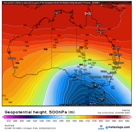
Figure 3: Broad upper level longwave analysed at 500hPa (~18,500ft) on ECMWF model for 01/11/22 showing sheer size of the system affecting SE Australia – source Meteologix
Showers will begin to become more scattered than widespread in the evening with less inland penetration as the entire system begins to move away to the east. Low level streams such as the one up the Spencer Gulf into Melrose etc will start to setup as winds moderate.
Wednesday 2nd
Stream showers will continue during the day but become quite isolated for most areas temporarily. The reason for this is yet another sneaky front will move up around the backside of the longwave trough during the evening bringing a band of showers but nothing remotely close to the one the night prior.
Thursday 3rd
A large ridge of high pressure will begin to muscle in from the west, contracting the shower activity to more southern coasts and ranges but a cool to cold southerly flow will remain.
Rainfall: The following is from the start of the event to about 9am Fri 4th Nov
Eyre Peninsula:
General 25-35mm isol 40mm about Lower EP. Totals decreasing about NE EP but still in the order of 15-20mm.
Upper North:
General 30-40mm, isol totals to 60mm about known wet spots/elevated terrain and those affected by streams. Totals decreasing further east off back of ranges down to 10-15mm
Lower North:
General 35-45mm isol totals to 65-70mm about higher peaks and known wet spots or in locations affected by streams. Totals decreasing off backs of ranges down to about 15-25mm and in the far west of the district down to about 25-35mm.
Yorke Peninsula:
General 20-30mm, isol totals to 40mm potentially about the foot and in any areas that setup with streams. Totals may decrease a smidge towards the eastern coast down to 15-20mm but generally a fairly even spread.
Kangaroo Island:
General 25-30mm across the island, possible to 40mm about the western end and down to 20mm over the eastern end.
Adelaide Plains:
General 25-35mm, increasing to 40-50mm closer to the foothills. Totals decreasing closer to the coast and western suburbs in the order of 18-25mm.
Mt.Lofty Ranges:
General 40-60mm totals, however scattered totals to 70mm are possible with isolated higher falls in known wet spots to 80-90mm. A sharp decline off back of the ranges and SE of the ranges down to 15-25mm.
Riverland:
General 10-15mm with isolated totals to about 20mm. Chance of rapid 15-20mm dumps in strong thunderstorms on 30th also. Totals decreasing in far north down to 8-10mm.
Mallee:
General 15-25mm, isolated 30mm falls possible in the far South/SW and also to 25mm or so in strong thunderstorms on 30th. Totals a little lighter towards the Riverland and eastern border in the order of 10-15mm.
Upper SE:
General 20-30mm, isolated 35mm falls possible in the south. Also possible to see 25-30mm in strong thunderstorms on 30th. Totals decreasing a little in far NE-E down to 15-20mm.
Lower SE:
General 25-35mm, isolated 50mm falls closer to the southern coastline. Not much under 25mm but perhaps a pocket or two down to 20mm in the far N of the district.
Western VIC:
General 25-35mm in the SW, with higher totals to 50mm possible about the Southern coastline and Grampians. Totals decreasing with northern extent to 15-25mm through the Wimmera and 8-15mm through the Mallee although isolated 20-30mm dumps are possible from strong thunderstorms through the afternoon and evening of the 30th.
Final Notes:
- Most significant weather system of the growing season with a mix of strong to severe thunderstorms initially on 30th
- Damaging to destructive winds in supercell thunderstorms late 30th as well as potential for large hail and intense rainfall
- Deep low over Bight moving SE later 30th with damaging winds chiefly about the coastline and adjacent inland agricultural areas
- Multiple strong cold fronts rotating around a broad and large upper longwave trough with cold air penetrating well inland delivering squally showers, isolated cold air thunderstorms and small hail.
- Combination of cold air, squally showers and strong winds will pose a significant risk to freshly shorn lambs and sheep.
- Slight chance of a dusting of snow about higher peaks of the Southern Flinders Ranges and also the Mt.Lofty Ranges
So, a lot of unwanted rainfall there, perhaps a few of you can handle a little more due to the cooler temperatures but certainly anyone east of the ranges will be well done by now I’d say after the wet October. Also, the Lower and Upper North are likely done but unfortunately these last two regions will see maximum impact rainfall wise from this event.
A small respite with a nice ridge after for about 4 days with sunny and mild to warm conditions however beyond this I expect more troughs to deepen from the west, albeit less significant than the one we are about to see but more on this with the November outlook to come in a few days time. Link to temporary blog website: https://farmweathersa.blogspot.com/
Happy Farming and Cheers from The Weatherman
*Note – For interest only, all thoughts are of The Weatherman and may not be reproduced without my consent.


Comments
Post a Comment