August 2022 outlook SA
August 2022 outlook SA
*Forecast prepared between July 31st-Aug 2nd 2022
Review:
G’Day everyone, I trust that you are all keeping well – it's been tough July for many but the hard yards for most will be over soon (and myself I’ve nearly complete Dry July, a nice cold ale won’t touch the sides I can tell you).
Dry and cold was the order of the month, with a number of blocks of frosty nights caused by significant high-pressure systems. As explained in the mid-month update plus subsequent quick update in the past couple of weeks, the main trigger for all of this has been the powerful upstream blocking caused by a large number of East Coast Lows (ECL’s) and general strong mid-latitude cyclones/lows in the Western Pacific. This effectively held up the traffic causing highs to dominate across Australia with fronts squashed down.
There was a slight improvement towards the end of the month which was expected with some moisture feeding in from the NW and also some NE with weak rainbands and mid-level showers from two cold fronts, one on 22nd and the second slightly better one on the 24th. 3-8mm totals with isolated 10mm falls occurred over the Mallee and parts of the Lower and Upper North that needed some rainfall, but the triggers were underwhelming to say the least. Now looking back and putting it all into a picture, we can see the dryness very clearly in the decile chart below:
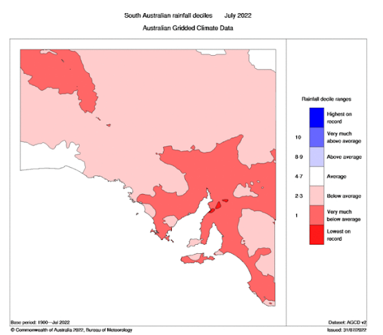
Figure 1: July 2022 rainfall deciles for SA – source BoM http://www.bom.gov.au/climate/
Well below average was the order of the month, and some near record low pockets over the Upper North which so often rely on a deep SW flow in streams to get their winter rainfall.

Figure 2: July 2022 % of mean rainfall – source BoM http://www.bom.gov.au/climate/
Figure 2 is quite telling and shows only the coastal fringes of the Far West Coast and SW YP making dents in the dryness. The Upper North, N/NE EP, and Pastoral areas had very poor months overall. Reviewing the July outlook, despite some agencies going for wetter at the start of the month, it performed reasonably well with pattern trend close to expectations however the main difference was a longer hold of the block resulting in a lesser improvement to the second half of the month than originally anticipated. Text below:
“This time wasted with dryness is going to come at the cost of an average to above average month with a much greater chance of generally finishing in the average to below average bracket for most districts despite the activity picking up from mid-month. I can see especially trying times for the Riverland, Northern Mallee, Northern and parts of the Upper North District and into the Pastorals with below average rainfall a greater chance there. Northern Eyre Peninsula is also within this risk though they will at least have some more room to move than the aforementioned districts. Above average odds look far less for most but if there is going to be anywhere that manages to get close it will be Kangaroo Island to Lower Yorke Peninsula and possibly southern portions of the Fleurieu but this will be an uphill battle.”
Meteorological Discussion:
Now reach a critical junction in the year which will determine the direction of many crops no doubt. August is a crucial time for many, and a poor month here often causes issues down the line. I’ve mentioned many times August to October should see things become much wetter and that outlook has not changed apart from the drier second half of July. Big blocking like we have seen breaking down usually causes great instability in the jetstream patterns with chaos reigning supreme. The Saturn opposition aligning with the full moon will play a part in driving some of this from Mid-Month as well so expect the wild jetstream action to continue.
July was very poor as mentioned, but this has happened in the past before we snapped back hard one month later. I touched on this in the last update that we have done this before and one year we did it very well was in 1992. A dry July ended up with a wet August as cut off lows dominated later in the month.

Figure 3: July 1992 rainfall anomalies – source BoM http://www.bom.gov.au/climate/

Figure 4: August 1992 rainfall anomalies – source BoM http://www.bom.gov.au/climate/
That is clearly a marked turnaround one month later. I envisage a much-improved effort however not to the level and spread we see here but a good month, nonetheless.
Now as the time of typing this (Monday evening) we have seen a significant change in the synoptic scale pattern with NW cloudbands moving in from the Indian and strong fronts slamming into SW WA. This is all thanks to a large Long Wave Trough (LWT) rearing up and peaking over the WA longitude with a nice shove from strong high pressure ridging off the Antarctic Continent. This Long Wave Trough will cause a large and complex multi-centred low to develop and move slowly eastwards over the next week with a good increase in rainfall (and certainly wind) to the southern coastline of WA, SA and VIC and not to mention significant swells and coastal erosion to exposed beaches.
I’ll break the next week down into days to make it easier to read as it is a complex scenario (much better than a few big highs!).
Tuesday 2nd
A strong cold front, the lead in a series of fronts wrapping around a massive, broad and complex Southern Ocean low, containing up to 6 centers, will move into the west of the state early in the day. Supported by a powerful subtropical Jetstream aloft, this will be accompanied by a large NW cloud band extending out of the Indian Ocean. The strongest and deepest low center will get down to around 963hPa well south of Perth and at first this will remain slow moving but later in the day should start to take a NE track towards the mainland before slowly weakening.
The initial lower levels will be fairly dry so a large portion of the cloud band will be middle and upper-level cloud without any rainfall. Due to the strength of the longwave behind and the speed of the front, strong to gale force northerly winds will develop well ahead of the front during the day and extend eastwards as the front also moves east. Damaging gusts in excess of 90km/hr are likely and it wouldn’t surprise me to see some gusts in excess of 100km/hr about exposed coasts and islands as well as some elevated terrain later in the afternoon. A mid-level rain band will extend from the NW ahead of the cold front during the day, reaching Eyre Peninsula by about 11am and Adelaide by 1:30pm with areas of patchy light rain. This band will only give small totals and will be destroyed by the dry air as it moves further east with lighter and patchier falls east of the ranges. Big winds from the N at the same time as rain almost always in my experience results in low totals however it is merely the start of much more. Behind the mid-level rain band, the cold front will still be moving in and although it will be sliding SE a bit the further east it goes, it will still remain quite sharp and thus combined with the dynamic lift aloft result in a band of heavier showers and isolated thunderstorms along it. This activity should roughly impact the Eyre Peninsula by 6pm and Adelaide by 8:30-9pm. More spasmodic totals can be expected here due to the convective nature but north of about Goyder's line will once again struggle. Much heavier activity is likely about Kangaroo Island and the general southern coastline with possible damage from stronger cells not without a chance due to some turning of winds in the lower levels.
Wednesday 3rd
The first front will have contracted to the east by the early hours leaving a moderate to fresh NW flow in its wake. Another cold front will move in swiftly from the west across the top of the NE moving deep low to the SW. This front will once again begin the SE slide on approach but act to
freshen those NW/N winds once more however not to the strength of the previous day due to a slacker pressure gradient. The front should reach KI by about 2:30-3pm and into the Adelaide area by about 8:30-9pm though pre-frontal orographic precipitation may get enough lift to bring some showers before the scattered shower frontal band moves through, chiefly for southern districts south of about Clare. Impacts north of here will be minimal and generally dry. Across the NE corner of the state, we should see some elevated isolated showers and thunderstorms develop within a cloudband as the jetstream begins to get squeezed by the approaching low from the SW.
Thursday 4th
Across the upper NE Pastoral, a thickening band of scattered showers and isolated thunderstorms will gradually turn to areas of rain and isolated thunderstorms along the jetstream with some useful totals up to 15mm possible. This cloudband will thicken up further and go on to produce solid rainfall in NSW, in particular up against the western slopes of the Great Divide with 20-40mm generally and much higher in excess of 50mm over higher terrain. Further south the deep low that has been moving in from the SW will begin to weaken but will still be fairly strong in the 985hPa region as it passes below KI. A trough will extend north of the low and gradually move in from west. Showers will gradually increase from the west during the day as NW winds become strong across most districts with damaging NW to W gusts likely about exposed western and southern coasts. Squally showers and isolated thunderstorms will extend eastwards from the Bight later Thursday reaching the Eyre Pen by 9-930am and the Adelaide area by 3-4pm. The activity will be sliding a lot as it moves in with more frequent and heavier showers and isolated thunderstorms more likely south of about Cummins to Minlaton to Sellicks Beach and down to the Coorong. Showers will be especially frequent and heavy about the Mt.Lofty Ranges during the evening with local heavy falls likely. I should note that until the winds swing more SW, the Riverland, Upper North (especially eastern portions) & northern Mallee will see minimal rainfall due to strong rain shadowing and lack of northern reach (in the Upper North’s case). The better rainfall here should begin from Friday the 5th.
Friday 5th
The low will move slowly eastwards to the south of the state directing a blustery and cold W/SW flow across most of the state with frequent showers, heavy at times with some possible small hail and isolated thunderstorms. This will likely be the wettest day for more inland areas, especially so as another embedded shortwave trough rotates up and over the back side of the low with daytime heating allowing more convection across inland areas. Watch out though for a dry slot wrapping
through the low, these huge complex lows are notorious for this bands of dry air embedded between larger shower clusters. Further small troughs are also likely around this low as it slings up various cold air complexes.
Saturday 6th
Another kink in the low is likely with a shortwave trough re-invigorating showers out of the SW with a brief isolated cold air thunderstorm possible anywhere over southern to eastern agricultural areas, particularly during the afternoon. Shower activity will then become more isolated as the high-pressure system takes hold although this high will not be a strong one thankfully.
From here on in things become a little more complex due to the fast-moving pattern with strong interactions between the tropics and colder air. The most likely scenario is a cold front and associated deep low to the south to move quickly eastwards around the 9th-10th with potential for some pre-frontal shower or thunderstorm activity before more blustery and squally showers around the top of the low after with good falls moreso into the ranges. This is one thing I have noted that we are seeing the early signs of pe-frontal troughing (spring like) and the WA heat low develop. This is extra important in getting that moisture to come down south earlier (when the moisture is available like it is this year).
Another cut off low or trough system is possible around the 14th-16th but will cover more in the mid-month update. A special update will come out if the 9th-10th system looks strong enough.
Frost risk is the greatest on Monday 8th as the high mentioned above moves eastwards with a lot of that cold air to sink. A further risk is possible from approx 13th-15th if high pressure does line up in this period, it will be once again moving in on the back of cold air aloft.
Overall, August will deliver above average rainfall for most districts with a chance of much above average rainfall over the NE Pastoral, Kangaroo Island, Western Eyre Peninsula and the SE Districts. Most other areas should at least come close to their average. Below average rainfall is generally not expected over many areas although a risk remains over the western interior north of the Nullarbor and the flats behind the Flinders.
Climate Drivers
The Pacific continues to hold a fairly consistent pattern with the cooler Humboldt Current pushing north of Peru and holding cooler anomalies over the Eastern Pacific in general whilst the warmth persists In the Western Pacific, most notably the Coral Sea. It also should be noted that the Nino 3.4 region over the Central Pacific has also begun to cool once more as the strong trade winds have stopped the warmer water from the west returning to the east to fully destroy any chances of a triple dip La Nina. I think we will most certainly get there with this pattern and that will mean another wet spring and especially summer for the Eastern states. Refer to Figure 5&6 below in any case.

Figure 5: Current SST anomalies – source Tropical Tidbits - https://www.tropicaltidbits.com/analysis/ocean/

Figure 6: Current Nino 3.4 Index showing resumption of cooling (more negative values) - source Tropical Tidbits https://www.tropicaltidbits.com/analysis/ocean/
Now moving onto the Indian and there has been only a slight change since the last update 2 weeks ago with a little warming in the Western Indian however fear not, this is only a pulse in the overall cooling trend there. Once the MJO pushes east, the westerlies will resume to upwell more colder water. The Eastern Indian and waters north of the mainland through Indonesia have remained warmer than average. The one area that has really changed is the Bay of Bengal. There has been marked warming in the last 2 weeks which is a great sign.
I also thought I’d show a comparison to how we are travelling with respect to the 2016 Negative IOD that was the strongest recorded since official records began. It was a very wet late winter and spring with Adelaide having the second wettest year on record behind the all-conquering 1992 which was phenomenally wet through late winter, all of spring and December as discussed earlier.

Figure 7: June 2016 SST anomalies – source The Longpaddock https://www.longpaddock.qld.gov.au/seasonal-climate-outlook/sea-surface-temperature/

Figure 8: June 2022 SST anomalies – source The Longpaddock https://www.longpaddock.qld.gov.au/seasonal-climate-outlook/sea-surface-temperature/
Looking at both next to each other we can deduce a number of things. Firstly, the Pacific shows the La Nina in 2022 whereas in 2016 we did not have that at all with a lot of heat still being used up from the monster 2015 El Nino. The Western Indian is quite similar between the two but the Eastern shows that 2016 the warmest water was to the NW of the mainland but this year it is to the NE. That water is still to move west so it explains partially why July 2016 was quite wet as the Negative IOD was more established and ready for its peak in September 2016. I do think this year we are well on
the way, but the peak of impacts is more likely from September through to November as explained in the section above with reference to 1992. It should be noted though (and have mentioned many times previously) that I do not expect rainfall this year to be as substantial as 2016 or especially 1992.
Moving onto the MJO and we have now an important area of persistence for the MJO. It has been fairly slow moving in phase 3 for a while now with westerly winds off Sumatra and this can be reflected in the 850hPa anomaly chart below in Figure 9:

Figure 9: 850hPa (5,000ft) vector wind anomalies – source NOAA https://www.cpc.ncep.noaa.gov/products/precip/CWlink/MJO/pentad850winds.shtml
I’ve circled in purple the key focus of greater than normal westerly wind anomalies in purple. This is smack bang inside the Eastern IOD box. Note the change from July 20th-24th to the 25th-29th. This marked increase in winds has caused a lot of convection to develop with a Tropical Cyclone named by the Joint Typhoon Warning Centre (JTWC). This has been a great source of moisture that has
started to enroach on the mainland from the NW and is responsible for our increasing NW cloudband activity in recent days.

Figure 10: 200hPa (40,000ft) vector wind anomalies – source NOAA https://www.cpc.ncep.noaa.gov/products/precip/CWlink/MJO/pentad200winds.shtml
And what have we above in Figure 10? A marked increase in NW winds aloft in the upper levels off WA to drive that moisture towards the mainland so all the dots line up from what we see in the oceans to the atmosphere and the resultant satellite imagery. This is an important sign of Ocean to atmosphere connection at multiple levels, at the 850hPa level and at 200hPa level. Of course, these anomalies will ebb and flow, but I wanted to show you at least how we can explain and verify the current events.
I expect the MJO in coming weeks to remain weak to moderate in nature but consistent through phases 3-5 and re-emerging back in the Indian again to further drive those westerly winds into Sumatra and get our negative IOD going further with some warming there.
The SAM has been positive for much of July with high pressure being dominant holding back the westerly belt. In years when we have ample tropical moisture, a balanced approach is best through the winter and spring period. Fortunately, the index has moved back to the neutral to slightly negative region making it easier for lows and fronts to impact Australia from the SW. I expect near neutral values for a week or two at least before a swing back positive again but not to the levels we saw I July.
Districts:
For the districts, I thought I would try splitting a few of the regions in more complex weather scenarios such as this fortnight for interest sakes. In mundane or less dynamic conditions I will keep the districts as I’ve been doing. Please pass your feedback to either Alex or Peter, or with any further suggestions. Once I am doing this full time, I’ll have much more of my own time to add in greater detail and cover more regions.
Eyre Peninsula
· Northern & Eastern Eyre Peninsula
Strong cold front moving in from west later on 2nd. Strong to gale force northerly winds ahead of front with possible pockets of raised dust at times. A band of light rain developing with cloudband ahead of front from late morning. A clearance behind the band before showers and isolated thunderstorms develop ahead of and along the cold front during the late afternoon and evening before clearing later. Weakening front passing to south during evening of 3rd generating isolated showers. Fine at first before NW winds strengthening again on thurs 4th ahead of trough extending off deep low to the south with scattered showers increasing during the afternoon and evening. Isolated thunderstorms possible towards the south of the region. Shower activity becoming more isolated towards sunrise Friday 5th however with heating and a secondary trough should re-invigorate during the day with a risk of an isolated thunderstorm again. Shower activity continuing on Saturday 6th as yet another trough rotates up from the low although activity will be more isolated later. Lingering morning shower activity possible on 7th before high pressure moves in.
Fine on 8th and early 9th before a cold front moves in from west. Possible pre-frontal isolated thundery showers ahead of isolated to scattered showers near the front. Winds will likely be fresh at
times. Follow up trough or low possible around 14th. Slight frost risk on morning of 8th and poss again from 13th-15th approx. Rainfall for the period around 10-20mm, though decreasing to 5-8mm near the Pastoral border and far NE Eyre Pen.
· Western & Lower Eyre Peninsula
Strong cold front moving in from west later on 2nd. Strong to gale force northerly winds ahead of front. A band of light rain developing with cloudband ahead of front from late morning. A clearance behind the band before showers and isolated thunderstorms develop ahead of and along the cold front during the late afternoon and evening before clearing later. Some locally heavy falls possible about the Western coasts with thunderstorms. Weakening front passing to south during late afternoon and evening of 3rd generating isolated showers. Fine at first before NW winds strengthening again on thurs 4th ahead of trough extending off deep low to the south with scattered showers increasing and becoming heavier during the morning and afternoon. Isolated thunderstorms and small hail possible in stronger cells. Local heavy falls once again closer to the coast. Shower activity becoming more isolated towards sunrise Friday 5th however with heating and a secondary trough should re-invigorate during the day with a risk of an isolated thunderstorm again. Shower activity continuing Saturday 6th as yet another trough rotates up from the low although activity will be more isolated later. Lingering morning shower activity possible on 7th before high pressure moves in.
Fine on 8th and early 9th before a cold front moves in from west. Possible pre-frontal isolated thundery showers ahead of scattered showers and isolated thunderstorms near and in wake of front with colder air. Winds will likely be fresh at times. Follow up trough or low possible around 14th. Slight frost risk away from coast on morning of 8th and poss again from 13th-15th approx. Rainfall for the period around 25-35mm with isolated local falls to 55mm particularly in locations that manage multiple thunderstorm cells.
Upper North
Strong cold front moving in from west later on 2nd. Strong to gale force northerly winds ahead of front with possible pockets of raised dust at times in dry areas. A band of light rain developing with cloudband ahead of front from early afternoon. A clearance behind the band before showers and isolated thunderstorms develop ahead of and along the cold front during the evening before clearing later. Activity much more isolated over the Flinders north of about Quorn. Weakening front passing to south during evening of 3rd generating isolated showers and chiefly in south only. Fine at first before NW winds strengthening again on thurs 4th ahead of trough extending off deep low to the south with isolated showers gradually increasing during the evening though rain shadow and lee drying will limit precipitation to the east at night. Shower activity becoming more isolated towards sunrise Friday 5th however with heating and a secondary trough should re-invigorate during the day with a risk of an isolated thunderstorm later in the afternoon. Local heavy falls about higher terrain. Shower activity continuing on Saturday 6th as yet another trough rotates up from the low although activity will be more isolated later. Lingering morning shower or drizzle stream activity possible on 7th before high pressure moves in.
Fine on 8th and early 9th before a cold front moves in from west. Possible pre-frontal isolated thundery showers ahead of isolated to scattered showers near the front. Winds will likely be fresh at times. Follow up trough or low possible around 14th. Slight to moderate frost risk on morning of 8th and poss again from 13th-15th approx. Rainfall for the period around 15-25mm, though decreasing to 8-15mm over Flinders and off back of ranges. Locally heavier totals about higher terrain and known wet spots to 50mm.
Lower North
Strong cold front moving in from west later on 2nd. Strong to gale force northerly winds ahead of front with possible pockets of raised dust at times in dry areas. A band of light rain developing with cloudband ahead of front from early afternoon. A clearance behind the band before showers and isolated thunderstorms develop ahead of and along the cold front during the evening before clearing later. Activity much more isolated in the far east towards the back of ranges. Weakening front passing to south during evening of 3rd generating isolated showers. Fine at first before NW winds strengthening again on thurs 4th ahead of trough extending off deep low to the south with isolated showers gradually increasing during the evening though rain shadow and lee drying will limit precipitation to the east at night. Shower activity becoming more isolated towards sunrise Friday 5th however with heating and a secondary trough should re-invigorate during the day with a risk of an isolated thunderstorm later in the afternoon. Local heavy falls about higher terrain. Shower activity continuing on Saturday 6th as yet another trough rotates up from the low although activity will be more isolated later. Lingering morning shower or drizzle stream activity possible on 7th before high pressure moves in.
Fine on 8th and early 9th before a cold front moves in from west. Possible pre-frontal isolated thundery showers ahead of isolated to scattered showers near and in wake of front in colder air. Winds will likely be fresh at times. Follow up trough or low possible around 14th. Slight to moderate frost risk on morning of 8th and poss again from 13th-15th approx. Rainfall for the period around 25-35mm, though decreasing to 10-15mm off back of ranges. Locally heavier totals about higher terrain and known wet spots to 55mm.
Yorke Peninsula
· Northern Yorke Peninsula
Strong cold front moving in from west later on 2nd. Strong to gale force northerly winds ahead of front with possible pockets of raised dust at times in dry areas. A band of light rain developing with cloudband ahead of front from early afternoon. A clearance behind the band before showers and isolated thunderstorms develop ahead of and along the cold front during the early evening before clearing later. Weakening front passing to south during evening of 3rd generating isolated showers. Fine at first before NW winds strengthening again on thurs 4th ahead of trough extending off deep low to the south with isolated showers, gradually increasing and becoming scattered during the afternoon and evening. Shower activity, initially more frequent and heavier in the early hours becoming more isolated towards sunrise Friday 5th however with heating and a secondary trough should re-invigorate during the day with a risk of an isolated thunderstorm later in the afternoon. Shower activity continuing on Saturday 6th as yet another trough rotates up from the low although activity will be more isolated later. Lingering morning shower or drizzle stream activity possible on 7th before high pressure moves in.
Fine on 8th and early 9th before a cold front moves in from west. Possible pre-frontal isolated thundery showers ahead of isolated to scattered showers near and in wake of front in colder air. Winds will likely be fresh at times. Follow up trough or low possible around 14th. Slight frost risk on morning of 8th and poss again from 13th-15th approx. Rainfall for the period around 20-30mm, though pockets to the north around 17-20mm. Locally heavier totals with locations that receive multiple thunderstorm activity to 45mm.
· Lower Yorke Peninsula
Strong cold front moving in from west later on 2nd. Strong to gale force northerly winds ahead of front. A band of light rain developing with cloudband ahead of front from early afternoon. A clearance behind the band before showers and isolated thunderstorms develop ahead of and along the cold front during the early evening before clearing later. Some locally heavy falls possible about the foot with thunderstorms. Weakening front passing to south during late afternoon and evening of 3rd generating isolated to scattered showers. Fine at first before NW winds strengthening again on thurs 4th ahead of trough extending off deep low to the south with scattered showers increasing and becoming heavier during the afternoon and evening. Isolated thunderstorms and small hail possible in stronger cells. Local heavy falls over the foot once again. Shower activity, initially heavier and more frequent, becoming more isolated briefly towards sunrise Friday 5th however with heating and a secondary trough should re-invigorate during the day with a risk of an isolated thunderstorm
again. Shower activity continuing Saturday 6th as yet another trough rotates up from the low although activity will be more isolated later. Lingering morning shower activity possible on 7th before high pressure moves in.
Fine on 8th and early 9th before a cold front moves in from west. Possible pre-frontal isolated thundery showers ahead of scattered showers and isolated thunderstorms near and in wake of front with colder air. Winds will likely be fresh to strong at times. Follow up trough or low possible around 14th. Slight frost risk away from coast on morning of 8th and poss again from 13th-15th approx. Rainfall for the period around 25-35mm with isolated local falls to 50mm particularly in locations that manage multiple thunderstorm cells.
Kangaroo Island
Strong cold front moving in from west later on 2nd. Strong to gale force northerly winds ahead of front. A band of light rain developing with cloudband ahead of front from early afternoon. A clearance behind the band before showers and isolated thunderstorms develop ahead of and along the cold front during the early evening before becoming more isolated later then clearing early 3rd. Some locally heavy falls possible about the western end with thunderstorms. Weakening front passing to south during mid to late afternoon and evening of 3rd generating a band of showers and a possible isolated thunderstorm. Fine at first before NW winds strengthening again on thurs 4th ahead of trough extending off deep low to the south with scattered showers increasing and becoming heavier from late morning. Isolated thunderstorms and small hail possible in stronger cells. Local heavy falls likely once again. Shower activity, initially heavier and more frequent, becoming more isolated briefly towards sunrise Friday 5th however with heating and a secondary trough should re-invigorate during the day with a risk of an isolated thunderstorm again. Shower activity continuing Saturday 6th as yet another trough rotates up from the low although activity will be more isolated later. Lingering morning shower activity possible on 7th before high pressure moves in.
Fine on 8th and early 9th before a cold front moves in from west. Possible pre-frontal isolated thundery showers ahead of scattered showers and isolated thunderstorms near and in wake of front with colder air. Winds will likely be fresh to strong at times. Follow up trough or low possible around 14th. Slight frost risk near centre of island on morning of 8th and poss again from 13th-15th approx. Rainfall for the period around 40-50mm with isolated local falls to 75mm near the western end. Totals decreasing a little towards the far eastern end in the order of 30-40mm.
Adelaide Plains
Strong cold front moving in from west later on 2nd. Strong to gale force northerly winds ahead of front. A band of light rain developing with cloudband ahead of front from mid-afternoon. A clearance behind the band before showers and isolated thunderstorms develop ahead of and along the cold front during the early evening before clearing later. Possible local heavy falls closer to foothills. Weakening front passing to south during evening of 3rd generating isolated to scattered showers. Fine at first before NW winds strengthening again on thurs 4th ahead of trough extending off deep low to the south with showers gradually increasing during the afternoon and becoming heavier in the evening. Isolated thunderstorms and small hail possible. Local heavy falls once again near foothills. Shower activity becoming more isolated towards sunrise Friday 5th however with heating and a secondary trough should re-invigorate during the day with a risk of an isolated thunderstorm. Shower activity continuing on Saturday 6th as yet another trough rotates up from the low although activity will be more isolated later. Lingering morning shower or drizzle stream activity possible on 7th before high pressure moves in.
Fine on 8th and early 9th before a cold front moves in from west. Possible pre-frontal isolated thundery showers ahead of scattered showers and isolated thunderstorms near and in wake of front with colder air. Winds will likely be fresh to strong at times. Follow up trough or low possible around 14th. Slight frost risk on morning of 8th and poss again from 13th-15th approx. Rainfall for the period around 35-45mm with isolated local falls to 60mm near the foothills. Totals decreasing a little towards western suburbs and N plains in the order of 25-35mm.
Mt.Lofty Ranges
Strong cold front moving in from west later on 2nd. Strong to gale force northerly winds ahead of front. A band of light rain developing with cloudband ahead of front from mid-afternoon. A clearance behind the band before showers and isolated thunderstorms develop ahead of and along the cold front during the early evening before clearing later. Local heavy falls likely. Weakening front passing to south during evening of 3rd generating isolated to scattered showers, heavier about the Fleurieu Peninsula. Fine at first before NW winds strengthening again on thurs 4th ahead of trough extending off deep low to the south with showers gradually increasing during the afternoon and becoming heavier in the evening. Isolated thunderstorms and small hail possible. Local heavy falls once again, especially about higher peaks and known wet spots. Shower activity becoming more isolated briefly towards sunrise Friday 5th however with heating and a secondary trough should re-invigorate during the day with a risk of an isolated thunderstorm. Shower activity continuing on Saturday 6th as yet another trough rotates up from the low although activity will be more isolated later. Lingering morning shower or drizzle stream activity possible on 7th before high pressure moves in.
Fine on 8th and early 9th before a cold front moves in from west. Possible pre-frontal isolated thundery showers ahead of scattered showers and isolated thunderstorms near and in wake of front with colder air, heavy at times. Small hail possible. Winds will likely be fresh to strong at times. Follow up trough or low possible around 14th. Slight frost risk on morning of 8th and poss again from 13th-15th approx. Rainfall for the period around 50-70mm with isolated local falls to 100mm. Known wet spots may exceed 120-130mm. Totals decreasing towards the northern ranges in the order of 35-50mm in in shadowed slopes to E/SE down to 20-30mm.
Riverland/Mallee
· Murray Valley
Strong cold front moving in from west later on 2nd. Strong to gale force northerly winds ahead of front with possible pockets of raised dust at times in dry areas. A band of light rain developing with cloudband ahead of front from mid-afternoon. A clearance behind the band before showers tending to light rain develop ahead of and along the cold front during the evening before clearing later. Weakening front passing to south during evening of 3rd generating isolated showers and chiefly in south only closer to the ranges. Fine at first before NW winds strengthening again on thurs 4th ahead of trough extending off deep low to the south with isolated showers gradually increasing during the evening though rain shadow and lee drying will limit precipitation at night. Shower activity becoming more isolated towards sunrise Friday 5th however with heating and a secondary trough should re-invigorate during the day, becoming scattered with a risk of an isolated thunderstorm later in the afternoon. Shower activity continuing on Saturday 6th as yet another trough rotates up from the low although activity will be more isolated later. Lingering morning shower or drizzle stream activity possible on 7th before high pressure moves in.
Fine on 8th and early 9th before a cold front moves in from west. Possible pre-frontal isolated thundery showers ahead of isolated to scattered showers near the front. Winds will likely be fresh at times. Follow up trough or low possible around 14th. Slight to moderate frost risk on morning of 8th and poss again from 13th-15th approx. Rainfall for the period around 10-20mm, though decreasing to 8-15mm. Locally heavier totals however to 25mm potentially in the south.
· Riverland/Northern Mallee
Strong cold front moving in from west later on 2nd. Strong to gale force northerly winds ahead of front with possible pockets of raised dust at times in dry areas. A band of light rain developing with cloudband ahead of front from mid-afternoon. A clearance behind the band before showers tending to light rain develop ahead of and along the cold front during the evening before clearing later.
Possible isolated thunderstorm ahead of the band or northern tip. Weakening front passing to south during evening of 3rd generating very isolated showers in the far SW. Fine at first before NW winds strengthening again on thurs 4th ahead of trough extending off deep low to the south with isolated showers gradually increasing during the evening though rain shadow and lee drying will limit precipitation at night. A morning shower or two after sunrise in the south on the 5th though with heating and a secondary trough, should see showers re-invigorate during the day, becoming scattered with a risk of an isolated thunderstorm later in the afternoon, less likely towards the north of the region. Shower activity continuing on Saturday 6th as yet another trough rotates up from the low although activity will be more isolated later. Lingering morning shower or drizzle stream activity possible on 7th before high pressure moves in.
Fine on 8th and early 9th before a cold front moves in from west. Possible pre-frontal isolated thundery showers ahead of isolated to scattered showers near the front. Winds will likely be fresh at times. Follow up trough or low possible around 14th. Slight to moderate frost risk on morning of 8th and poss again from 13th-15th approx. Rainfall for the period around 5-10mm, though decreasing to 3-5mm in the north. Locally heavier totals however up to 15-18mm potentially in the far south/SW.
· Southern Mallee
Strong cold front moving in from west later on 2nd. Strong to gale force northerly winds ahead of front with possible pockets of raised dust at times in dry areas. A band of light rain developing with cloudband ahead of front from mid-afternoon. A clearance behind the band before showers tending to light rain develop ahead of and along the cold front during the evening before clearing later. Possible isolated thunderstorm on leading edge. Weakening front passing to south during late evening of 3rd generating isolated showers in the south. Fine at first before NW winds strengthening again on thurs 4th ahead of trough extending off deep low to the south with isolated showers gradually increasing during the evening though rain shadow and lee drying will limit precipitation at night moreso for the eastern half of the district. Showers should increase on the 5th with heating and a secondary trough during the day, becoming scattered with a risk of an isolated thunderstorm during the afternoon, less likely towards the north of the region. Shower activity continuing on Saturday 6th in a SW stream with better penetration across the region as yet another trough rotates up from the low although activity will be more isolated later. Lingering morning shower or drizzle stream activity possible on 7th before high pressure moves in.
Fine on 8th and early 9th before a cold front moves in from west. Possible pre-frontal isolated thundery showers ahead of isolated to scattered showers near the front. Winds will likely be fresh at times. Follow up trough or low possible around 14th. Slight to moderate frost risk on morning of 8th and poss again from 13th-15th approx. Rainfall for the period around 10-20mm, though decreasing to 8-15mm in the north and far NE. Locally heavier totals however up to 25mm potentially in the far south/SW.
Upper SE
Strong cold front moving in from west late on 2nd. Strong to gale force northerly winds ahead of front with possible pockets of raised dust at times in dry areas. A band of light rain developing with cloudband ahead of front from early evening. A clearance behind the band before showers tending to light rain develop ahead of and along the cold front during the evening before clearing later. Possible isolated thunderstorm or two on leading edge. Weakening front passing to south during late evening of 3rd generating isolated to scattered showers in the south. Fine at first before NW winds strengthening again on thurs 4th ahead of trough extending off deep low to the south with isolated showers gradually increasing during the evening about the Coorong coast. Showers should increase on the 5th with heating and a secondary trough during the day, becoming scattered with a risk of an isolated thunderstorm during the afternoon. Shower activity continuing on Saturday 6th in a SW stream with better penetration across the region as yet another trough rotates up from the low although activity will be more isolated later. Lingering morning shower or drizzle stream activity possible on 7th before high pressure moves in.
Fine on 8th and early 9th before a cold front moves in from west. Possible pre-frontal isolated thundery showers ahead of isolated to scattered showers near the front. Winds will likely be fresh at times. Follow up trough or low possible around 14th. Slight to moderate frost risk on morning of 8th and poss again from 13th-15th approx. Rainfall for the period around 25-35mm, though decreasing to 12-18mm in the north and far NE. Locally heavier totals however up to 40mm potentially in the far south.
Lower SE/ SW VIC
Strong cold front moving in from west late on 2nd. Strong to gale force northerly winds ahead of front. A band of light rain developing with cloudband ahead of front from early evening. A clearance behind the band before showers tending to light rain develop ahead of and along the cold front during the evening before clearing later. Possible isolated thunderstorm or two on leading edge. Local heavy falls possible, chiefly over the LSE. Showers continuing in colder air behind in unstable westerly flow. Weakening front passing to south during late evening of 3rd generating scattered showers and possible isolated brief thunderstorms. Fine at first before NW winds strengthening again on thurs 4th ahead of trough extending off deep low to the south with isolated to scattered showers gradually increasing during the evening, chiefly about the coast, though lesser penetration into VIC whilst flow is westerly. Showers should increase on the 5th with heating and a secondary trough during the day, becoming scattered with a risk of an isolated thunderstorm during the
afternoon with local heavy falls again. Small hail possible. Shower activity continuing on Saturday 6th in a SW stream with better penetration across the region as yet another trough rotates up from the low although activity will be more isolated later. Lingering morning shower or drizzle stream activity possible on 7th before high pressure moves in.
Fine on 8th and early 9th before a cold front moves in from west. Possible pre-frontal isolated thundery showers ahead of showers and isolated thunderstorms near the front with local heavy falls and small hail likely. Winds will likely be fresh to strong and squally at times. Follow up trough or low possible around 14th. Slight to moderate frost risk on morning of 8th and poss again from 13th-15th approx. Rainfall for the period around 30-50mm, though decreasing 25-30mm in the north and far NE of both districts. Locally heavier totals however up to 75mm potentially about the coastline of the Lower SE especially due to westerly exposure.
Wimmera
Strong cold front moving in from west late on 2nd. Strong to gale force northerly winds ahead of front with possible pockets of raised dust at times in dry areas. A band of light patchy rain developing with cloudband ahead of front from mid evening but not a lot in it. A clearance behind the band before showers tending to areas of rain develop ahead of and along the cold front during the evening before clearing later. Rainband thickening with eastward extent. Possible isolated thunderstorm or two on leading edge. Weakening front passing to south during late evening of 3rd generating isolated to scattered showers in the south with the risk of a thunderstorm. Fine at first before NW winds strengthening again on thurs 4th ahead of trough extending off deep low to the south though any shower activity will largely be confined to the Grampians and light. Showers should increase on the 5th with heating and a secondary trough during the day, becoming scattered with a risk of an isolated thunderstorm during the afternoon. Shower activity continuing on Saturday 6th in a SW stream with better penetration across the region as yet another trough rotates up from the low although activity will be more isolated later. Lingering morning shower or drizzle stream activity possible on 7th before high pressure moves in.
Fine on 8th and early 9th before a cold front moves in from west. Possible pre-frontal isolated thundery showers ahead of isolated to scattered showers near the front. Winds will likely be fresh at times. Follow up trough or low possible around 14th. Slight to moderate frost risk on morning of 8th and poss again from 13th-15th approx. Rainfall for the period around 15-25mm, though decreasing to 10-15mm in the north and far NE. Locally heavier totals however up to 40mm potentially in the far south and over higher terrain.
Mallee
Strong cold front moving in from west later on 2nd. Strong to gale force northerly winds ahead of front with possible pockets of raised dust at times in dry areas. A band of light rain developing with cloudband ahead of front from late afternoon. A clearance behind the band before showers tending to light rain develop ahead of and along the cold front during the evening before clearing later but not a lot in it. Possible isolated thunderstorm ahead of the band or northern tip. Weakening front passing to south during evening of 3rd generating very isolated showers in the far S. Fine at first before NW winds strengthening again on thurs 4th ahead of trough extending off deep low to the south. Isolated mid-level showers may develop over the east. On the 5th though with heating and a secondary trough, should see showers re-invigorate during the day, becoming scattered with a risk of an isolated thunderstorm later in the afternoon, less likely towards the north of the region. Shower activity continuing on Saturday 6th as yet another trough rotates up from the low although activity will be more isolated later. Lingering morning shower or drizzle stream activity possible on 7th before high pressure moves in.
Fine on 8th and early 9th before a cold front moves in from west. Possible pre-frontal isolated thundery showers ahead of isolated to scattered showers near the front. Winds will likely be fresh at times. Follow up trough or low possible around 14th. Slight to moderate frost risk on morning of 8th and poss again from 13th-15th approx. Rainfall for the period around 7-12mm, though decreasing to 5-8mm in the far north. Locally heavier totals however up to 20-25mm potentially in the far south/SE closer to the Wimmera.
Finals Notes:
· Negative IOD beginning to finally show its hand, but this is just the start. Once we throw heat into the mix it will make systems a lot more volatile with an increased thundery risk through middle to later spring
· With increased rain risk comes increase in wind and those areas that are dry will especially struggle first with the wind before the rain makes its way in
· Overall outlook through to December is average to much above average rainfall with only smaller pockets receiving below average.
· Remember, despite the broadly wetter outlook, dry spells still will occur but they will be less lengthy in nature than usual.
Link to temporary blog website: https://farmweathersa.blogspot.com/
Happy Farming and Cheers from The Weatherman
*Note – For interest only, all thoughts are of The Weatherman and may not be reproduced without my consent.


Comments
Post a Comment