Special Update SA Strong Cold Front and Cut off Low May 29th-31st 2022
Special Update SA Strong cold front and cut off low May 29th-31st 2022
Review:
G’Day everyone, time to discuss this up and coming system and a significant one it still looks to be at that. This is the seasonal breaker for most districts. As explained in the previous update, we will see an increase in the penetration and strength of the systems as our pattern changes and season breaks. We begun with some scattered showers and isolated thunderstorms out west which weakened to patchy rain and general showers towards Central Districts before re-developing again out east and north the next day. Rainfall was patchy but most districts ranged between 3-12mm. Some isolated totals were record about the ranges and Eyre Pen over 20mm and numerous holes over both the Lower and Upper North as well as the Mallee. Further convective cells have flowed across the south central portions of the state both yesterday 27th and again today with a weakening front on the 28th ticking over some more totals and importantly keeping the low levels moist.
The good news is, those holes should get a fair piece of the pie from this event although more will still be required.
Meteorological Discussion
At the present point in time around early arvo on the 28th we have a classic NW cloudband of moisture intruding from the warm and moist Indian where our Negative IOD is beginning to develop. There is a good surge of moisture across from the Northern Hemisphere even which is then feeding into the jetstream and being rapidly slung SE. Further SW a strong upper trough and associated surface cold front is charging out of the deep south with the polar jetstream wrapping around the apex of the upper trough.
This system will stand up tall over the Bight area and cause the meeting of the polar and subtropical jetstreams, resulting in massive dynamic lift from aloft. In short, a cut off low will form in the Bight and move eastwards with the entire system intensifying all the way in. As this low forms, the system will gain what is termed a ‘Negative Tilt’ where the equatorial portion of the system leans forward to the east. This is essentially a ‘breaking wave’ and these types of lows often produce severe weather and plenty of rain. Quite often we see systems weakening on approach, infact I would say 75-80% of them weaken as they come in but this one is quite different. Referring to Figure 1 below, I have marked the cloudband with the red arrow and the cold air behind the front with the blue arrow. Watch the gap between these two close as they begin to marry up over SA where the upper-level divergence is very strong. This is an area where there is an evacuation of mass or air aloft so to create equilibrium there must be a corresponding rising of air from below and thus our low pressure intensifies.
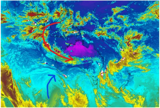
Figure 1: Satellite imagery for 10:30am local 28/05/22 showing developing system – source Weatherzone
In terms of output at first there is likely to be some areas of rain well inland associated with the NW cloudband, but scattered showers will increase ahead of the cold front. Along the front as it crosses the Bight there is likely to be a line of thunderstorms on the leading edge. This frontal band will cross Eyre Peninsula during the afternoon by late afternoon and into the Adelaide region by mid evening. The thunderstorms are likely to amalgamate into a broader, thicker rainband with embedded heavy rain likely, especially closer to the back edge and over areas where orographic lift into the ranges gives it a kick. This rainband will sweep across the Mallee and Riverland as well with good eastwards penetration due to the system strength. Behind the front through the evening a speckled mass of cold air will barrel into the Eyre Peninsula from the Bight with squally frequent cold air showers and isolated thunder. There is a slight risk of some small hail as well.
In terms of rainfall, it will still taper off as one ventures north over the Riverland as usual but I must say the southern half of the Mallee should do well. Squally winds are likely once winds turn more W to SW and also with any stronger convective cores within the frontal band itself. The strong dynamics with this system and associated wind shear may be conducive to more organised albeit isolated thunderstorms with a sneaky embedded weak tornado a slight somewhere in the dark, more likely further north towards the Southern Pastorals or Flinders portion of the Upper North where convection will be less affected by spreading to rain. If, however, the frontal band manages to hold its convection together for longer, then this risk increases slightly as the negative tilting of the frontal structure will allow a low-level NE wind in, increasing low level wind shear. The main case against a higher risk of this threat is instability to maintain longer lived convection remains quite low, this will be primarily dynamically driven. But please heed any warnings as damaging winds are still quite possible.
We should then see the cloudband wrap down and back under the low as it deepens before coming up the western flank. Somewhere over the Central Districts/Mt.Lofty Ranges through Adelaide the band is likely to pivot on itself with frequent showers, heavy at times and perhaps tending to rain at times through Monday morning 30th. A sting in the tail around the back side of the low further to the west across the West Coast and Eyre Peninsula is likely to cause a higher risk of damaging W/SW winds here.

Figure 2: 300hPa (30,000ft) winds in km/hr for 9:30pm local time 29/05/22 showing meeting of two jetstreams with peak over SA – source Meteorologix
In Figure 2 above we can clearly see the polar jetstream meeting the subtropical jetstream over SA causing an acceleration of the flow aloft.

Figure 3: 500hPa (18,500ft) temperature prognosis for 9:30am local 29/05/22 showing north south alignment of cold pool – source Meteorologix

Figure 4: 500hPa (18,500ft) temperature prognosis for 9:30pm local 29/05/22 showing north south alignment of cold pool – source Meteorologix
Now I can hear some people asking about what is this negative tilting business? Figure 3 and 4 more so will show how that is being achieved. In Figure 3 I have drawn a black line across the axis of the cold air field. A mere 12hours later, I have drawn the line again and this time the axis has changed with the top of it being further east than the bottom. It is ‘falling over’ or as I mentioned above a ‘breaking wave’. The more common systems have a positive tilt where the cold air slopes back to the west with northward extent. Always look for these negatively tilted systems as they are usually more significant. The September 28-29 2016 cut off low with a tornado outbreak was a very good example of such a system but with significantly more instability and even greater wind shear. Finally, a weak trough will move in from the SW later on the 30th with another increase in showers as the flow turns more SW generally. A secondary trough and associated colder air will rapidly swipe up from the SSW early tuesday, especially over the SE Districts but still affecting others with an increase in winds once again as a deep, cold and blustery SW flow establishes across the state. Small hail is
likely south of about Salt Creek as well as isolated cold air thunder. Showers will be shallower the further N and NW one goes with activity more isolated over the Eyre Peninsula, Upper North and Riverland. A moderate strength high pressure system will then move in from the west ahead of another likely NW Cloudband and cut off low with good rainfall. The pattern will become established for another week or two with further fronts and possible lows as we break this season very hard indeed into June.
Rainfall: The following is from the start of the event to about 9am Wed 1st
Eyre Peninsula:
General 15-20mm with scattered totals to 25mm. Isolated 30mm possible about the exposed SW coast. Totals decrease about far NE EP down to around 8-10mm.
Upper North:
General 20-30mm with scattered falls to 40mm. Isolated falls to 50mm about higher peaks and known wet spots. Totals decreasing to the far N and E off the back of the ranges down to 8-15mm.
Lower North:
General 25-35mm falls, with scattered 40mm totals. Isolated heavier falls to 50-55mm about higher terrains and known wet spots. Totals decreasing off backs of ranges down to around 15-20mm.
Yorke Peninsula:
General 25-35mm falls, with scattered 40mm totals. Isolated heavier falls to 50mm possible in south. Totals decreasing towards eastern coast around 20mm or so.
Kangaroo Island:
General 20-30mm falls, with scattered 35mm totals. Isolated heavier falls to 40-45mm possible about the western end. Totals decreasing over far east down to around 15-20mm or so.
Adelaide Plains:
General 25-40mm falls, with scattered 45-50mm totals. Isolated heavier falls to 60mm near foothills and anywhere under the pivoting band. Totals decreasing over far southern suburbs down to around 18-25mm or so.
Mt.Lofty Ranges:
General 35-55mm falls, with scattered 60-70mm totals. Isolated heavier falls to 80mm about known wet spots and higher peaks and anywhere under the pivoting band. Totals decreasing over far southern/SE ranges down to around 25-30mm or so. Watch out for some local flooding of creeks and rivers.
Riverland:
General 12-20mm with scattered falls to 25mm. Isolated falls to 30mm in the south. Totals decreasing towards the N Riverland around 8-15mm.
Mallee:
General 15-25mm with scattered falls to 30mm. Isolated falls to 35mm in the south. Totals decreasing towards the Riverland around 12-20mm.
Upper SE:
General 15-20mm with scattered falls to 30mm. Isolated falls to 35mm in the north. Totals decreasing towards the Southern border around 15-20mm.
Lower SE:
General 12-20mm with scattered falls to 25mm. Isolated falls to 30mm in the north. Totals potentially slightly less about western coasts but mostly in the 12-18mm range.
Western VIC:
A quick little tidbit here as I know this forecast is reaching a few of you over the border so I thought I’d add it in for this event. Overall, the system has a slightly less reach into VIC, moreso the southern half of the western districts (Mallee, Wimmera and South West (although the extreme coast of the South West District will do much better from the fronts on tuesday). Due to the strong cutting off of the low over SA, the band will pull back into the low a bit causing less rainfall over the northern portions of the South West District and southern Wimmera. The Mallee however looks to do fairly well at this stage. Rainfall totals over Western VIC will generally be 15-25mm over the Mallee with isolated 30mm totals possible further in the NW. The Wimmera should see 12-20mm though tapering off to more 8-12mm in the south. Similarly for the SW District, the northern portions may end up around 8-15mm with an increase back to 25-35mm over the coastal strip with locally heavier totals to 40mm possible. Hopefully out of all of this a great breaking rain for everyone and there is plenty more coming so expect boggy paddocks and water lying around before you know it. And finally, I thought I’d chuck in that I’m currently knocking back a glorious red thanks to the very kind donation of Peter, one of my contacts who has helped me out immensely, a big thanks mate, I’m surprised I managed to finish this in good English as there isn’t much left now...
Link to temporary blog website: https://farmweathersa.blogspot.com/
Happy Farming and Cheers from The Weatherman
*Note – For interest only, all thoughts are of The Weatherman and may not be reproduced without my consent.


Comments
Post a Comment