SA Quick update Upper trough with showers and thunderstorms February 28th-March 1st 2022
SA Quick update Upper trough with showers and thunderstorms Feb 28th-Mar 1st 2022
G’Day all, thought I’d whip out a quick little update on things tomorrow, after a fairly quiet spell here we are finally getting a bit of instability (well today we already saw the start over the Lower SE)
Meteorological Discussion
In short, we will see an upper-level low move up from the SW overnight to be located over the Spencer Gulf by sunrise. This low will move slowly eastwards during the day to be located roughly over the southern Mallee by sunset. At the surface being cradled by a large high-pressure system, we will have a trough which will move west and deepen a little in response to the approaching upper low. With these two interacting with each other we will see a de-stabilisation of the atmosphere causing lapse rates to steepen thanks to the cooling aloft provided by the upper low.
Initially some mid-level showers and isolated thunderstorms may fire up in some convergence ahead of the main upper low from the gulf areas and east with a focus east/SE of the ranges with a then gradual increase in shower and thunderstorm activity elsewhere though given the convective nature as usual there will be plenty of gaps.
Increasing low level moisture from the eastern states feeding into the trough combined with the lift from the upper trough and solar heating, should result in surface-based showers and thunderstorms developing in the afternoon behind the initial wave of activity in a slack steering environment meaning where they form is likely where they will stay for the most part. This will result in locally heavy falls and flash flooding should you get under one of these intense cores. Small to medium sized hail is also likely in stronger cells with some reasonable accumulations possible. The main focus for this activity will be the Central to Northern Mt.Lofty Ranges and northern Adelaide plains and right up through the ranges in the Lower and Upper North and possibly northern Yorke Pen and I wouldn’t rule out Eyre Peninsula for some afternoon development either given the moist ground there but not as strong as storms further east. Also, large chunks of the Riverland and Mallee and into the SE Districts. The activity should ease/clear the quickest over the ranges and west with lingering activity into the evening and night likely over the Mallee/SE Districts where the surface trough will linger and the upper low will be right overhead.
On the 1st of March, the trough will still be sitting near the eastern border so we should see afternoon showers and isolated thunderstorms again chiefly east of the ranges with a little more pronounced S-N or SW-NE steering flow around the back side of the upper low. There will be less grunt and intensity to thunderstorms than the day prior.
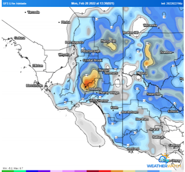
A quick little pic above showing the Lifted Index for 1:30pm tomorrow (28th). This is essentially a horizontal slice through the atmosphere at 500hPa (18,500ft) showing the difference between a rising theoretical parcel of air and the surrounding environment. So, we can see here that the parcels rising will be roughly up to 4-6C warmer than their surroundings north of Adelaide which means they have a greater potential to rise more quickly than other areas. Note* this is one index, and a far broader analysis of data is always used to gain a better understanding of what the atmosphere is doing such as surface convergence, upper-level lift and overall Convection Available Potential Energy (CAPE).
Rainfall
Rainfall totals will be highly variable due to the convective nature of the event. Many will get less than 1mm, especially those west of the gulf areas. North of about Adelaide should see somewhere around 3-8mm increasing to potentially 10-15mm in parts of the Lower and Upper North. Isolated dumps under thunderstorms to 40mm are possible.
On the Mt.Lofty Ranges NE/E of the city we should see general totals of 5-10mm however thunderstorm activity will give scattered totals to 20mm and isolated 30-40mm falls, especially towards the back of the ranges.
East of the ranges over the Riverland, Mallee and SE Districts activity should be a bit more widespread and longer lasting with a repeat effort on the 1st (albeit much weaker). Totals here generally should be in the order of 8-15mm with scattered 20-30mm totals and some isolated totals with thunderstorms to 50mm.
Thoughts are also with our SE QLD friends at this time, the relentless rainfall there is as extreme as I have ever seen in my years of weather watching. I’ll touch on the event there a little bit more in the March outlook in a few days time. Happy Farming and Cheers from The Weatherman
*Note – For interest only, all thoughts are of The Weatherman and may not be reproduced without my consent.


Comments
Post a Comment