Posts

Showing posts from May, 2024

Quick Update Opening rains and cold front May 30-31st 2024

Image
  Quick Update Opening rains/cold front May 30-31st 2024 G’Day one and all, hope you are doing well. It is finally time for that opening rain of the season, so I thought I’d pop out a quick little update on the expected progression of the system(s). Meteorological Discussion To the charts and currently we see a cloudband developing across WA bringing with it some moisture sourced from the Central Indian Ocean, the area I noted from the last update as we finally have a longwave trough with a high enough amplitude to grab some of it. A cold front is marked to the rear of the cloudband extending out of a deepening surface low south of the Bight. This low will continue to deepen rapidly in response to the strong forcing of the broad upper trough behind it. A secondary trough associated with the core of the cold air/cold pool has been slamming SW WA overnight with strong cold air thunderstorms and copious amounts of hail. The warm waters off the coast of WA have assisted in adding more ...

May update 2024 SA

Image
May update 2024 SA *Forecast prepared between May 18th-21st 2024 Review: G’Day everyone, we have gone past Mid-May and without change in the current pattern over the state, which is no doubt a concern to many of you. We’ll take a look back quickly at the last couple of weeks and also discuss the April pressure anomalies which have now been uploaded. Figure 1: April 2024 500hPa (18,500ft) pressure anomalies – source NOAA https://www.ncei.noaa.gov/monitoring-content/sotc/global/hgtanomaly-global/hgtanomaly-global-202404.png Figure 1 above tells a very grave tale about the level of blocking that has been going on showing in red the areas of higher-than-normal pressure for April. The blue areas represent lower than normal pressure. We can see here that the stronger Longwave near New Zealand has caused quite a roadblock upstream with the large red high-pressure area south of about WA. However, there is a slightly larger high-pressure area below Africa and an even bigger one SW of South Amer...

May Outlook 2024 SA

Image
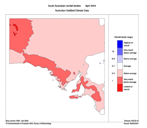
May Outlook 2024 SA *Forecast prepared between May 2nd to 6th 2024 Review: G’Day everyone, definitely time for an important update that I am sure many of you have been waiting for given the state of the autumn season to date. As usual there is good and bad news but will go into more detail in the discussion and drivers section. April did not finish off well, and was very dry with high pressure dominating. There were some onshore showers about chiefly exposed coasts and a lucky 14mm or so near Cowell from a training mid-level cell ahead of an upper low but all in all, meagre totals less than 1-4mm for most districts which was fairly close to expectations from the last update. WA has been very dry as well however just recently, hints of a change in patterns has impacted the SW portion of the state with a tight upper low bringing showers and thunderstorms on the 30th and 1st of May followed by a sliding cold front with heavier showers and thunderstorms chiefly south of Perth. A lot of thi...